|
|
 |
|

|
|
|
Impervious surface extraction based on Sentinel-2A and Landsat8 |
ZHAO Yi1,2,3,4( ), XU Jianhui1,2, ZHONG Kaiwen1(), WANG Yunpeng3,4, HU Hongda1,2, WU Pinghao1,2,3,4 ), XU Jianhui1,2, ZHONG Kaiwen1(), WANG Yunpeng3,4, HU Hongda1,2, WU Pinghao1,2,3,4 |
1. Key Laboratory of Guangdong for Utilization of Remote Sensing and Geographical Information System, Guangdong Engineering Laboratory for Geographic Spatio-temporal Big Data, Guangzhou Institute of Geography, Guangdong Academy of Sciences, Guangzhou 510070, China
2. Southern Marine Science and Engineering Guangdong Laboratory (Guangzhou), Guangzhou 511458, China
3. Guangzhou Institute of Geochemistry, Chinese Academy of Sciences, Guangzhou 510640, China
4. University of the Chinese Academy of Sciences, Beijing 100049, China |
|
|
|
|
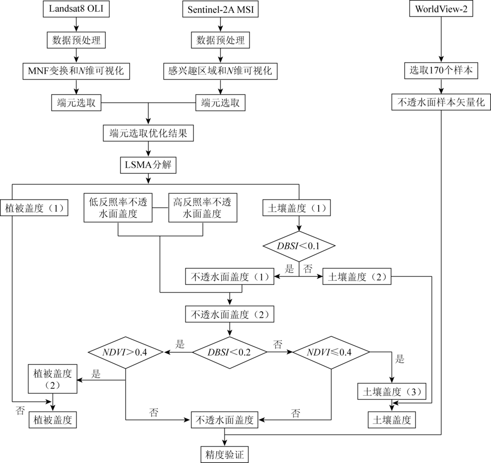
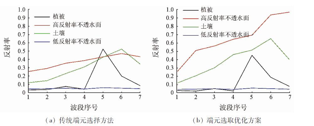
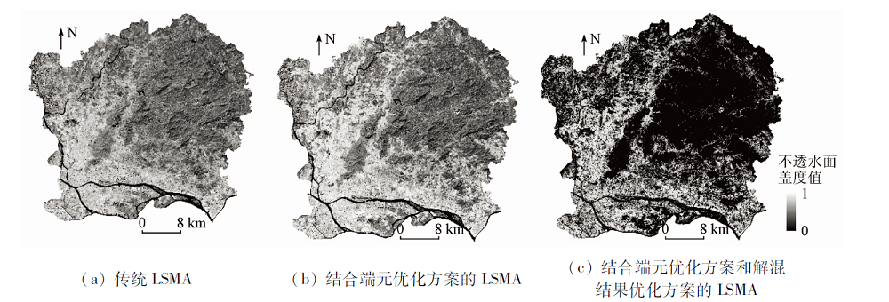
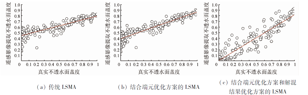
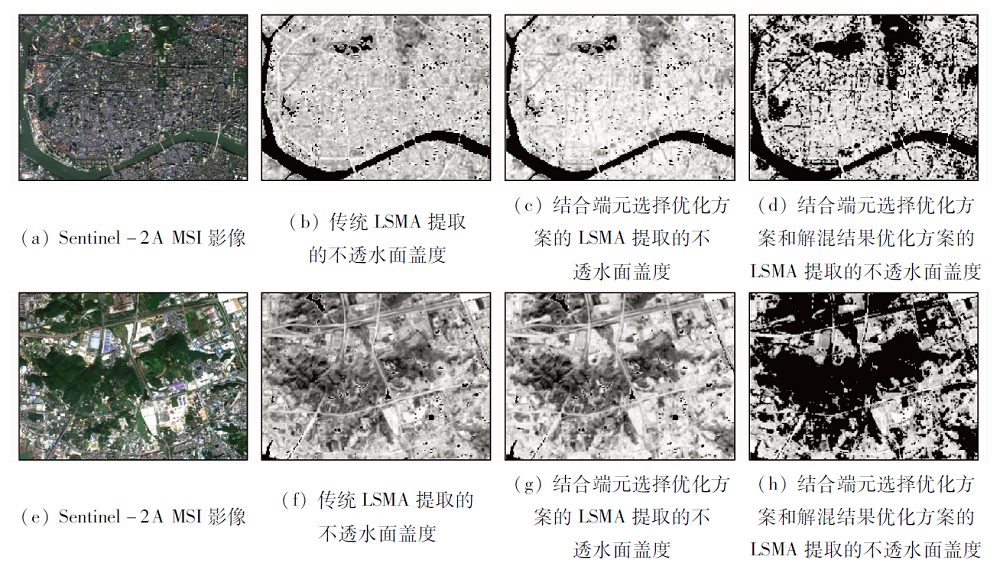
Abstract The extraction of impervious surface (IS) is very important for the development of cities, and linear spectral mixture analysis is commonly adopted to calculate the fraction of IS in the mixed pixel to improve the extraction of the urban IS at the subpixel scale. Owing to errors in the spectra of pure pixels selected from remote sensing images, incorrect fractions of different land cover types often emerge after unmixing. In this paper, the modified endmember selection was proposed to improve the accuracy of the spectral information of endmembers. Sentinel-2A images were applied to selected endmembers to get the spectral, which was used to modify the spectral information of the endmembers from Landsat8. In addition, the optimization scheme of LSMA results in which the normalized differential vegetation index (NDVI) and dry bare-soil index (DBSI) thresholds are used to optimize the mixing results was applied to improve the accuracy of LSMA results. With the WorldView-2 remote sensing image for sample verification, the results showed that the accuracy of IS fraction extracted by the method in this paper was 20% higher than that of the traditional method, providing reliable theoretical support for endmember selection and IS extraction.
|
| Keywords
Sentinel-2A
modified endmember selection
linear spectral mixture analysis
impervious surface
Sentinel-2A
modified endmember selection
linear spectral mixture analysis
impervious surface
|
|
|
|
Corresponding Authors:
ZHONG Kaiwen
E-mail: zhaoyiww@gdas.ac.cn;zkw@gdas.ac.cn
|
|
Issue Date: 21 July 2021
|
|
|
| [1] |
Elvidge C D, Tuttle B T, Sutton P C, et al. Global distribution and density of constructed impervious surfaces[J]. Sensors, 2007, 7:1962-1979.
doi: 10.3390/s7091962
url: http://www.mdpi.com/1424-8220/7/9/1962
|
| [2] |
Zhu H, Li Y, Fu B. Estimating impervious surfaces by linear spectral mixture analysis under semi-constrained condition[C]// International Conference on Remote Sensing,Environment and Transportation Engineering (RSETE 2013). Paris: Atlantis Press, 2013:357-360.
|
| [3] |
Zhang H S, Lin H, Zhang Y Z. Remote sensing of impervious surfaces in tropical and subtropical areas[M]. Boca Raton: CRC Press/Taylor & Francis Group, 2015.
|
| [3] |
Zhang H S, Lin H, Zhang Y Z. Remote sensing of impervious surfaces in tropical and subtropical areas[M]. Boca Raton: CRC Press/Taylor & Francis Group, 2015.
|
| [4] |
Fan F, Wei F, Weng Q. Improving urban impervious surface mapping by linear spectral mixture analysis and using spectral indices[J]. Canadian Journal of Remote Sensing, 2015, 41(6):577-586.
doi: 10.1080/07038992.2015.1112730
url: http://www.tandfonline.com/doi/full/10.1080/07038992.2015.1112730
|
| [5] |
Xu J, Zhao Y, Zhong K, et al. Measuring spatio-temporal dynamics of impervious surface in Guangzhou,China,from 1988 to 2015,using time-series Landsat imagery[J]. Science of the Total Environment, 2018, 627:264-81.
doi: 10.1016/j.scitotenv.2018.01.155
url: https://linkinghub.elsevier.com/retrieve/pii/S004896971830192X
|
| [6] |
Lu D, Li G, Kuang W, et al. Methods to extract impervious surface areas from satellite images[J]. International Journal of Digital Earth, 2014, 7:93-112.
doi: 10.1080/17538947.2013.866173
url: http://www.tandfonline.com/doi/abs/10.1080/17538947.2013.866173
|
| [6] |
Lu D, Li G, Kuang W, et al. Methods to extract impervious surface areas from satellite images[J]. International Journal of Digital Earth, 2014, 7:93-112.
doi: 10.1080/17538947.2013.866173
url: http://www.tandfonline.com/doi/abs/10.1080/17538947.2013.866173
|
| [7] |
赵怡, 许剑辉, 钟凯文, 等. LSMA结合NDBI提取广州市部分城区不透水面的方法[J]. 地理空间信息, 2018, 16:90-93,10.
|
| [7] |
赵怡, 许剑辉, 钟凯文, 等. LSMA结合NDBI提取广州市部分城区不透水面的方法[J]. 地理空间信息, 2018, 16:90-93,10.
|
| [7] |
Zhao Y, Xu J H, Zhong K W, et al. Extraction of urban impervious surface in Guangzhou by LSMA with NDBI[J]. Geospatial Information, 2018, 16:90-93,10.
|
| [7] |
Zhao Y, Xu J H, Zhong K W, et al. Extraction of urban impervious surface in Guangzhou by LSMA with NDBI[J]. Geospatial Information, 2018, 16:90-93,10.
|
| [8] |
Xu H. Analysis of impervious surface and its impact on urban heat environment using the normalized difference impervious surface index (NDISI)[J]. Photogrammetric Engineering & Remote Sensing, 2010, 76:557-65.
|
| [8] |
Xu H. Analysis of impervious surface and its impact on urban heat environment using the normalized difference impervious surface index (NDISI)[J]. Photogrammetric Engineering & Remote Sensing, 2010, 76:557-65.
|
| [9] |
Esch T, Himmler V, Schorcht G, et al. Large-area assessment of impervious surface based on integrated analysis of single-date Landsat-7 images and geospatial vector data[J]. Remote Sensing of Environment, 2009, 113:1678-1690.
doi: 10.1016/j.rse.2009.03.012
url: https://linkinghub.elsevier.com/retrieve/pii/S0034425709000959
|
| [10] |
Sattari F, Hashim M, Pour A B. Thermal sharpening of land surface temperature maps based on the impervious surface index with the TsHARP method to ASTER satellite data:A case study from the metropolitan Kuala Lumpur,Malaysia[J]. Measurement, 2018, 125:262-78.
doi: 10.1016/j.measurement.2018.04.092
url: https://linkinghub.elsevier.com/retrieve/pii/S0263224118303713
|
| [11] |
Hu X, Weng Q. Impervious surface area extraction from IKONOS imagery using an object-based fuzzy method[J]. Geocarto International, 2011, 26:3-20.
doi: 10.1080/10106049.2010.535616
url: http://www.tandfonline.com/doi/abs/10.1080/10106049.2010.535616
|
| [11] |
Hu X, Weng Q. Impervious surface area extraction from IKONOS imagery using an object-based fuzzy method[J]. Geocarto International, 2011, 26:3-20.
doi: 10.1080/10106049.2010.535616
url: http://www.tandfonline.com/doi/abs/10.1080/10106049.2010.535616
|
| [12] |
许剑辉, 赵怡, 肖明虹, 等. 基于空间自回归模型的广州市NDVI和NDBI与气温关系研究[J]. 国土资源遥感, 2018, 30(2):186-194.doi: 10.6046/gtzyyg.2018.02.25.
doi: 10.6046/gtzyyg.2018.02.25
|
| [12] |
许剑辉, 赵怡, 肖明虹, 等. 基于空间自回归模型的广州市NDVI和NDBI与气温关系研究[J]. 国土资源遥感, 2018, 30(2):186-194.doi: 10.6046/gtzyyg.2018.02.25.
doi: 10.6046/gtzyyg.2018.02.25
|
| [12] |
Xu J H, Zhao Y, Xiao M H, et al. Relationship of air temperature to NDVI and NDBI in Guangzhou City using spatial autoregressive model[J]. Remote sensing for Land and Resources, 2018, 30(2):186-194.doi: 10.6046/gtzyyg.2018.02.25.
doi: 10.6046/gtzyyg.2018.02.25
|
| [12] |
Xu J H, Zhao Y, Xiao M H, et al. Relationship of air temperature to NDVI and NDBI in Guangzhou City using spatial autoregressive model[J]. Remote sensing for Land and Resources, 2018, 30(2):186-194.doi: 10.6046/gtzyyg.2018.02.25.
doi: 10.6046/gtzyyg.2018.02.25
|
| [13] |
Wang J, Wu Z F, Wu C S, et al. Improving impervious surface estimation:an integrated method of classification and regression trees (CART) and linear spectral mixture analysis (LSMA) based on error analysis[J]. GIScience & Remote Sensing, 2018, 55(4):583-603.
|
| [13] |
Wang J, Wu Z F, Wu C S, et al. Improving impervious surface estimation:an integrated method of classification and regression trees (CART) and linear spectral mixture analysis (LSMA) based on error analysis[J]. GIScience & Remote Sensing, 2018, 55(4):583-603.
|
| [14] |
Wu C, Murray A T. Estimating impervious surface distribution by spectral mixture analysis[J]. Remote Sensing of Environment, 2003, 84:493-505.
doi: 10.1016/S0034-4257(02)00136-0
url: https://linkinghub.elsevier.com/retrieve/pii/S0034425702001360
|
| [14] |
Wu C, Murray A T. Estimating impervious surface distribution by spectral mixture analysis[J]. Remote Sensing of Environment, 2003, 84:493-505.
doi: 10.1016/S0034-4257(02)00136-0
url: https://linkinghub.elsevier.com/retrieve/pii/S0034425702001360
|
| [15] |
Chen S, Le W. Linear spatial spectral mixture model[J]. IEEE Transactions on Geoscience & Remote Sensing, 2016, 54:3599-611.
|
| [15] |
Chen S, Le W. Linear spatial spectral mixture model[J]. IEEE Transactions on Geoscience & Remote Sensing, 2016, 54:3599-611.
|
| [16] |
Ridd M K. Exploring a V-I-S (vegetation-impervious surface-soil) model for urban ecosystem analysis through remote sensing:Comparative anatomy for cities?[J]. International Journal of Remote Sensing, 1995, 16:2165-2185.
doi: 10.1080/01431169508954549
url: https://www.tandfonline.com/doi/full/10.1080/01431169508954549
|
| [17] |
Weng Q, Lu D. A sub-pixel analysis of urbanization effect on land surface temperature and its interplay with impervious surface and vegetation coverage in Indianapolis,United States[J]. International Journal of Applied Earth Observation & Geoinformation, 2008, 10:68-83.
|
| [17] |
Weng Q, Lu D. A sub-pixel analysis of urbanization effect on land surface temperature and its interplay with impervious surface and vegetation coverage in Indianapolis,United States[J]. International Journal of Applied Earth Observation & Geoinformation, 2008, 10:68-83.
|
| [18] |
孙艳丽. 联合丰度信息与空谱特征的高光谱影像分类研究[D]. 北京:中国科学院大学(中国科学院遥感与数字地球研究所), 2017.
|
| [18] |
孙艳丽. 联合丰度信息与空谱特征的高光谱影像分类研究[D]. 北京:中国科学院大学(中国科学院遥感与数字地球研究所), 2017.
|
| [18] |
Sun Y L. Research on hypercpectral imagery classification by combing abundance information and spectral-spatial feature[J]. Beijing:Chinese Academy of Sciences (Institute of Remote Sensing and Digital Earth,Chinese Academy of Sciences), 2017.
|
| [18] |
Sun Y L. Research on hypercpectral imagery classification by combing abundance information and spectral-spatial feature[J]. Beijing:Chinese Academy of Sciences (Institute of Remote Sensing and Digital Earth,Chinese Academy of Sciences), 2017.
|
| [19] |
Li Y, Wang H, Li X B. Fractional vegetation cover estimation based on an improved selective endmember spectral mixture model[J]. PLoS One, 2015, 10(4):e0124608.
doi: 10.1371/journal.pone.0124608
url: https://dx.plos.org/10.1371/journal.pone.0124608
|
| [19] |
Li Y, Wang H, Li X B. Fractional vegetation cover estimation based on an improved selective endmember spectral mixture model[J]. PLoS One, 2015, 10(4):e0124608.
doi: 10.1371/journal.pone.0124608
url: https://dx.plos.org/10.1371/journal.pone.0124608
|
| [20] |
陈子玄, 武文波. 基于线性混合模型的端元提取方法综述[J]. 测绘科学, 2008, 33:49-51.
|
| [20] |
陈子玄, 武文波. 基于线性混合模型的端元提取方法综述[J]. 测绘科学, 2008, 33:49-51.
|
| [20] |
Chen Z X, Wu W B. A review on endmember extraction algorithms based on the linear mixing model[J]. Science of Surveying and Mapping, 2008, 33:49-51.
|
| [20] |
Chen Z X, Wu W B. A review on endmember extraction algorithms based on the linear mixing model[J]. Science of Surveying and Mapping, 2008, 33:49-51.
|
| [21] |
Lee J B, Woodyatt A S, Berman M. Enhancement of high spectral resolution remote-sensing data by a noise-adjusted principal components transform[J]. IEEE Transactions on Geoscience & Remote Sensing, 1990, 28:295-304.
|
| [21] |
Lee J B, Woodyatt A S, Berman M. Enhancement of high spectral resolution remote-sensing data by a noise-adjusted principal components transform[J]. IEEE Transactions on Geoscience & Remote Sensing, 1990, 28:295-304.
|
| [22] |
Fan F. The application and evaluation of two methods based on LSMM model:A case study in Guangzhou[J]. Remote Sensing Technology and Application, 2008, 23:272-277.
|
| [22] |
Fan F. The application and evaluation of two methods based on LSMM model:A case study in Guangzhou[J]. Remote Sensing Technology and Application, 2008, 23:272-277.
|
| [23] |
赵春晖, 郭蕴霆. 一种改进的快速N-FINDR端元提取算法[J]. 光子学报, 2015, 44:42-50.
|
| [23] |
赵春晖, 郭蕴霆. 一种改进的快速N-FINDR端元提取算法[J]. 光子学报, 2015, 44:42-50.
|
| [23] |
Zhao C H, Guo Y T. An improved fast N-FINDR endmember extraction algorithm[J]. Acta Photonica Sinica, 2015, 44:42-50.
|
| [23] |
Zhao C H, Guo Y T. An improved fast N-FINDR endmember extraction algorithm[J]. Acta Photonica Sinica, 2015, 44:42-50.
|
| [24] |
Drusch M, Bello U D, Carlier S, et al. Sentinel-2:ESA’s optical high-resolution mission for GMES operational services[J]. Remote Sensing of Environment, 2012, 120:25-36.
doi: 10.1016/j.rse.2011.11.026
url: https://linkinghub.elsevier.com/retrieve/pii/S0034425712000636
|
| [24] |
Drusch M, Bello U D, Carlier S, et al. Sentinel-2:ESA’s optical high-resolution mission for GMES operational services[J]. Remote Sensing of Environment, 2012, 120:25-36.
doi: 10.1016/j.rse.2011.11.026
url: https://linkinghub.elsevier.com/retrieve/pii/S0034425712000636
|
| [25] |
Zhang H K, Roy D P, Yan L, et al. Characterization of Sentinel-2A and Landsat-8 top of atmosphere,surface,and nadir BRDF adjusted reflectance and NDVI differences[J]. Remote Sensing of Environment, 2018, 215:482-494.
doi: 10.1016/j.rse.2018.04.031
url: https://linkinghub.elsevier.com/retrieve/pii/S0034425718301883
|
| [26] |
Xu J, Zhao Y, Zhong K, et al. Coupling modified linear spectral mixture analysis and soil conservation service curve number (SCS-CN) models to simulate surface runoff:Application to the main urban area of Guangzhou,China[J]. Water, 2016, 8:550.
doi: 10.3390/w8120550
url: http://www.mdpi.com/2073-4441/8/12/550
|
| [27] |
徐涵秋, 王美雅. 地表不透水面信息遥感的主要方法分析[J]. 遥感学报, 2016, 20:1270-1289.
|
| [27] |
徐涵秋, 王美雅. 地表不透水面信息遥感的主要方法分析[J]. 遥感学报, 2016, 20:1270-1289.
|
| [27] |
Xu H Q, Wang M Y. Remote sensing-based retrieval of ground impervious surfaces[J]. Journal of Remote Sensing, 2016, 20:1270-1289.
|
| [27] |
Xu H Q, Wang M Y. Remote sensing-based retrieval of ground impervious surfaces[J]. Journal of Remote Sensing, 2016, 20:1270-1289.
|
| [28] |
Wu C. Normalized spectral mixture analysis for monitoring urban composition using ETM+ imagery[J]. Remote Sensing of Environment, 2004, 93:480-92.
doi: 10.1016/j.rse.2004.08.003
url: https://linkinghub.elsevier.com/retrieve/pii/S0034425704002421
|
| [28] |
Wu C. Normalized spectral mixture analysis for monitoring urban composition using ETM+ imagery[J]. Remote Sensing of Environment, 2004, 93:480-92.
doi: 10.1016/j.rse.2004.08.003
url: https://linkinghub.elsevier.com/retrieve/pii/S0034425704002421
|
| [29] |
Zhou C L, Xu H Q. A spectral mixture analysis and mapping of impervious surfaces in built-up land of Fuzhou City[J]. Journal of Image and Graphics, 2007, 12(5):875-881.
|
| [29] |
Zhou C L, Xu H Q. A spectral mixture analysis and mapping of impervious surfaces in built-up land of Fuzhou City[J]. Journal of Image and Graphics, 2007, 12(5):875-881.
|
| [30] |
Xu H Q. A study on information extraction of water body with the modified normalized difference water index (MNDWI)[J]. Journal of Remote Sensing, 2005, 9:589-595.
|
| [30] |
Xu H Q. A study on information extraction of water body with the modified normalized difference water index (MNDWI)[J]. Journal of Remote Sensing, 2005, 9:589-595.
|
| [31] |
Otsu N. A threshold selection method from gray-level histograms[J]. IEEE Transactions on Systems Man & Cybernetics, 2007, 9:62-66.
|
| [31] |
Otsu N. A threshold selection method from gray-level histograms[J]. IEEE Transactions on Systems Man & Cybernetics, 2007, 9:62-66.
|
| [32] |
Kumar B P, Babu K R, Ramachandra M, et al. Data on identification of desertified regions in Anantapur district,Southern India by NDVI approach using remote sensing and GIS[J]. Data in Brief, 2020, 30:105560.
doi: 10.1016/j.dib.2020.105560
url: https://linkinghub.elsevier.com/retrieve/pii/S2352340920304546
|
|
Viewed |
|
|
|
Full text
|
|
|
|
|
Abstract
|
|
|
|
|
Cited |
|
|
|
|
| |
Shared |
|
|
|
|
| |
Discussed |
|
|
|
|
 2021,
Vol. 33
2021,
Vol. 33