|
|
 |
|

|
|
|
Hyperspectral estimation of black soil organic matter content based on wavelet transform and successive projections algorithm |
XIAO Yan1( ), XIN Hongbo1, WANG Bin2, CUI Li1, JIANG Qigang3 ), XIN Hongbo1, WANG Bin2, CUI Li1, JIANG Qigang3 |
1. College of Exploration and Surveying Engineering, Changchun Insititute of Technology, Changchun 130012, China
2. Changchun Institute of Surveying and Mapping, Changchun 130021, China
3. College of Geo-Exploration Science and Technology, Jilin University, Changchun 130026, China |
|
|
|
|
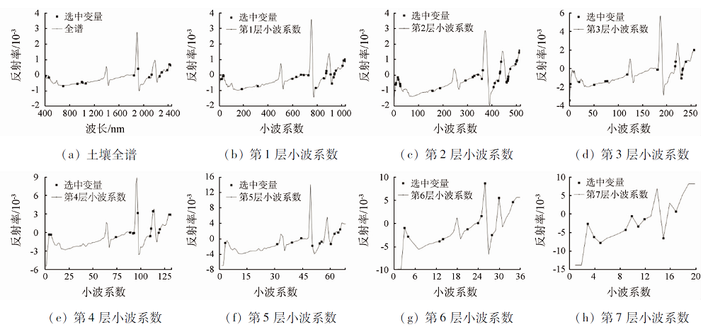
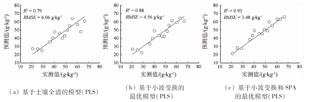
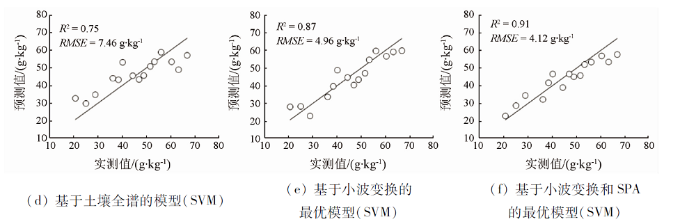
Abstract Black soil is a valuable land resource, and the content of organic matter is an important index reflecting soil fertility, state and degradation degree. In order to estimate black soil organic matter content more accurately, this paper proposes a hyperspectral estimation method based on wavelet transform and successive projections algorithm. In this paper,the soil samples collected in the typical black soil region were used as the research object,and the Vis-NIR spectral data of the soil obtained from analytical spectral deviees (ASD) spectrometer and the organic matter content through chemical analysis were used as the data sources.Firstly, wavelet transform was used to extract the wavelet coefficients of 1 to 7 levels, and then successive projections algorithm was used to select the variables from soil original spectrum and the wavelet coefficients of 1 to 7 levels respectively. Finally, based on the soil original spectrum, the wavelet coefficients of 1 to 7 levels and the selected variables based on successive projections algorithm respectively, partial least squares and support vector machine were used to build the estimation models. The results show that, by using wavelet transform and successive projections algorithm, not only the number of variables is reduced greatly, but also the accuracies of the models are improved. When using partial least squares method,R2 increases from 0.79 of the soil original spectrum to 0.93 of the wavelet coefficient of the sixth level, and RMSE decreases from 6.06 g·kg-1 to 3.48 g·kg-1. When support vector machine method is used, R2 increases from 0.75 of the soil original spectrum to 0.91 of the wavelet coefficient of the third level, and RMSE decreases from 7.46 g·kg-1 to 4.12 g·kg-1. The results indicate that the proposed method can be effectively used for the hyperspectral estimation of black soil organic matter content.
|
| Keywords
organic matter
hyperspectral
wavelet transform
successive projections algorithm
|
|
|
|
Issue Date: 21 July 2021
|
|
|
| [1] |
Rasmussen C, Heckman K, Wieder W R, et al. Beyond clay:Towards an improved set of variables for predicting soil organic matter content[J]. Biogeochemistry, 2018, 137(5):297-306.
doi: 10.1007/s10533-018-0424-3
url: https://doi.org/10.1007/s10533-018-0424-3
|
| [2] |
马玥, 姜琦刚, 孟治国, 等. 基于RF-GABPSO混合选择算法的黑土有机质含量估测研究[J]. 光谱学与光谱分析, 2018, 38(1):181-187.
|
| [2] |
Ma Y, Jiang Q G, Meng Z G, et al. Black soil organic matter content estimation using hybrid selection method based on RF and GABPSO[J]. Spectroscopy and Spectral Analysis, 2018, 38(1):181-187.
|
| [3] |
谢文, 赵小敏, 郭熙, 等. 基于RBF组合模型的山地红壤有机质含量光谱估测[J]. 林业科学, 2018, 54(6):16-23.
|
| [3] |
Xie W, Zhao X M, Guo X, et al. Spectrum based estimation of the content of soil organic matters in mountain red soil using RBF combination model[J]. Scientia Silvae Sinicae, 2018, 54(6):16-23.
|
| [4] |
陈红艳, 赵庚星, 李希灿, 等. 基于DWT-GA-PLS的土壤碱解氮含量高光谱估测方法[J]. 应用生态学报, 2013, 24(11):3185-3191.
|
| [4] |
Chen H Y, Zhao G X, Li X C, et al. Hyper spectral estimation method for soil alkali hydrolysable nitrogen content based on discrete wavelet transform and genetic algorithm in combining with partial least squares[J]. Chinese Journal of Applied Ecology, 2013, 24(11):3185-3191.
|
| [5] |
王延仓, 张兰, 王欢, 等. 连续小波变换定量反演土壤有机质含量[J]. 光谱学与光谱分析, 2018, 38(11):207-213.
|
| [5] |
Wang Y C, Zhang L, Wang H, et al. Quantitative inversion of soil organic matter content based on continuous wavelet transform[J]. Spectroscopy and Spectral Analysis, 2018, 38(11):207-213.
|
| [6] |
王延仓, 杨贵军, 朱金山, 等. 基于小波变换与偏最小二乘耦合模型估测北方潮土有机质含量[J]. 光谱学与光谱分析, 2014, 34(7):1922-1926.
|
| [6] |
Wang Y C, Yang G J, Zhu J S, et al. Estimation of organic matter content of north fluvo-aquic soil based on the coupling model of wavelet transform and partial least squares[J]. Spectroscopy and Spectral Analysis, 2014, 34(7):1922-1926.
|
| [7] |
李旭青, 李龙, 庄连英, 等. 基于小波变换和BP神经网络的水稻冠层重金属含量反演[J]. 农业机械学报, 2019, 50(6):226-232.
|
| [7] |
Li X Q, Li L, Zhuang L Y, et al. Inversion of heavy metal content in rice canopy based on wavelet transform and BP neural network[J]. Transactions of the Chinese Society for Agricultural Machinery, 2019, 50(6):226-232.
|
| [8] |
吴迪, 吴洪喜, 蔡景波, 等. 基于无信息变量消除法和连续投影算法的可见-近红外光谱技术白虾种分类方法研究[J]. 红外与毫米波学报, 2009, 28(6):423-427.
|
| [8] |
Wu D, Wu H X, Cai J B, et al. Classifying the species of exopalaemon by using visible and near infrared spectra with uninformative variable elimination and successive projections algorithm[J]. Journal of Infrared and Millimeter Waves, 2009, 28(6):423-427.
|
| [9] |
章海亮, 罗微, 刘雪梅, 等. 应用遗传算法结合连续投影算法近红外光谱检测土壤有机质研究[J]. 光谱学与光谱分析, 2017, 37(2):584-587.
|
| [9] |
Zhang H L, Luo W, Liu X M, et al. Measurement of soil organic matter with near infrared spectroscopy combined with genetic algorithm and successive projection algorithm[J]. Spectroscopy and Spectral Analysis, 2017, 37(2):584-587.
|
| [10] |
Peng X, Shi T, Song A, et al. Estimating soil organic carbon using VIS/NIR spectroscopy with SVMR and SPA Methods[J]. Remote Sensing, 2014, 6(4):2699-2717.
doi: 10.3390/rs6042699
url: http://www.mdpi.com/2072-4292/6/4/2699
|
| [11] |
印影. 黑土有机质含量的高光谱估测模型研究[D]. 长春:吉林大学, 2015.
|
| [11] |
Yin Y. Study on hyper-spectral models for predicting black soil organic matter content[D]. Changchun:Jilin University, 2015.
|
| [12] |
Sharma M, Pachori R B. A novel approach to detect epileptic seizures using a combination of tunable-Q wavelet transform and fractal dimension[J]. Journal of Mechanics in Medicine and Biology, 2017, 17(4):1740003.
doi: 10.1142/S0219519417400036
url: https://www.worldscientific.com/doi/abs/10.1142/S0219519417400036
|
| [13] |
Zhao R, Biswas A, Zhou Y, et al. Identifying localized and scale-specific multivariate controls of soil organic matter variations using multiple wavelet coherence[J]. Science of the Total Environment, 2018, 643:548-558.
doi: 10.1016/j.scitotenv.2018.06.210
url: https://linkinghub.elsevier.com/retrieve/pii/S0048969718322873
|
| [14] |
陈红艳, 赵庚星, 李希灿, 等. 小波分析用于土壤速效钾含量高光谱估测研究[J]. 中国农业科学, 2012, 45(7):1425-1431.
|
| [14] |
Chen H Y, Zhao G X, Li X C, et al. Application of wavelet analysis for estimation of soil available potassium content with hyperspectral reflectance[J]. Scientia Agricultura Sinica, 2012, 45(7):1425-1431.
|
| [15] |
栾福明, 熊黑钢, 王芳, 等. 基于小波分析的土壤碱解氮含量高光谱反演[J]. 光谱学与光谱分析, 2013, 33(10):2828-2832.
|
| [15] |
Luan F M, Xiong H G, Wang F, et al. The inversion of soil alkaline hydrolysis nutrient content with hyperspectral reflectance based on wavelet analysis[J]. Spectroscopy and Spectral Analysis, 2013, 33(10):2828-2832.
|
| [16] |
高洪智, 卢启鹏, 丁海泉, 等. 基于连续投影算法的土壤总氮近红外特征波长的选取[J]. 光谱学与光谱分析, 2009, 29(11):2951-2954.
|
| [16] |
Gao H Z, Lu Q P, Ding H Q, et al. Choice of characteristic near-infrared wavelengths for soil total nitrogen based on successive projection algorithm[J]. Spectroscopy and Spectral Analysis, 2009, 29(11):2951-2954.
|
| [17] |
沈掌泉, 卢必慧, 单英杰, 等. 基于变量选择的偏最小二乘回归法和田间行走式近红外光谱进行土壤碳含量测定研究[J]. 光谱学与光谱分析, 2013, 33(7):1775-1780.
|
| [17] |
Shen Z Q, Lu B H, Shan Y J, et al. Study on soil carbon estimation by on-the-go near-infrared spectra and partial least squares regression with variable selection[J]. Spectroscopy and Spectral Analysis, 2013, 33(7):1775-1780.
|
| [18] |
Xiao Y, Jiang Q, Wang B, et al. Object-oriented fusion of RADARSAT-2 polarimetric synthetic aperture Radar and HJ-1A multispectral data for land-cover classification[J]. Journal of Applied Remote Sensing, 2016, 10(2):026021.
doi: 10.1117/1.JRS.10.026021
url: http://remotesensing.spiedigitallibrary.org/article.aspx?doi=10.1117/1.JRS.10.026021
|
|
Viewed |
|
|
|
Full text
|
|
|
|
|
Abstract
|
|
|
|
|
Cited |
|
|
|
|
| |
Shared |
|
|
|
|
| |
Discussed |
|
|
|
|
 2021,
Vol. 33
2021,
Vol. 33