|
|
 |
|

|
|
|
Classification of remote sensing images based on multi-scale feature fusion using local binary patterns |
JIANG Yanan1( ), ZHANG Xin2, ZHANG Chunlei3, ZHONG Chengcheng1, ZHAO Junfang1 ), ZHANG Xin2, ZHANG Chunlei3, ZHONG Chengcheng1, ZHAO Junfang1 |
1. School of Science, China University of Geosciences(Beijing), Beijing 100083, China
2. School of Statistics, Beijing Normal University, Beijing 100875, China
3. Beijing Zhongdirunde Petroleum Technology Co.Ltd., Beijing 100083, China |
|
|
|
|
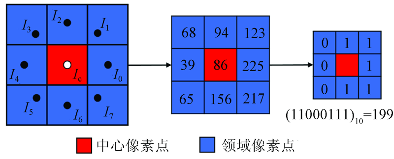
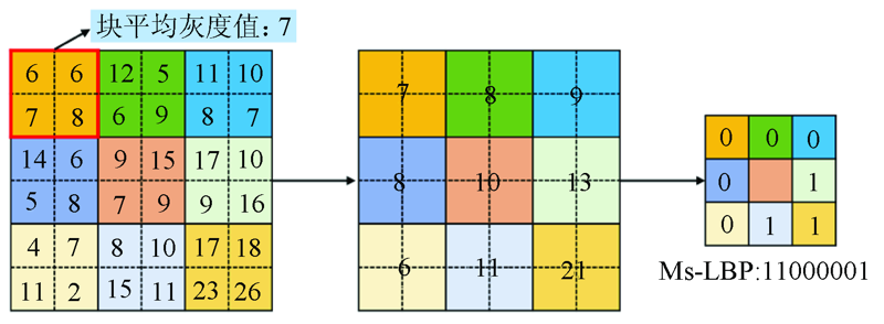
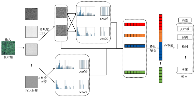
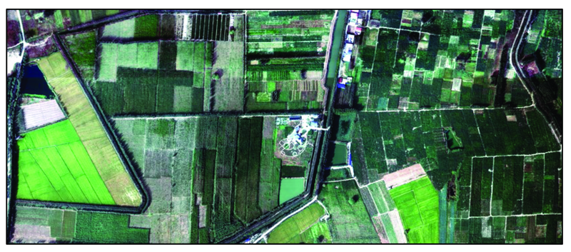
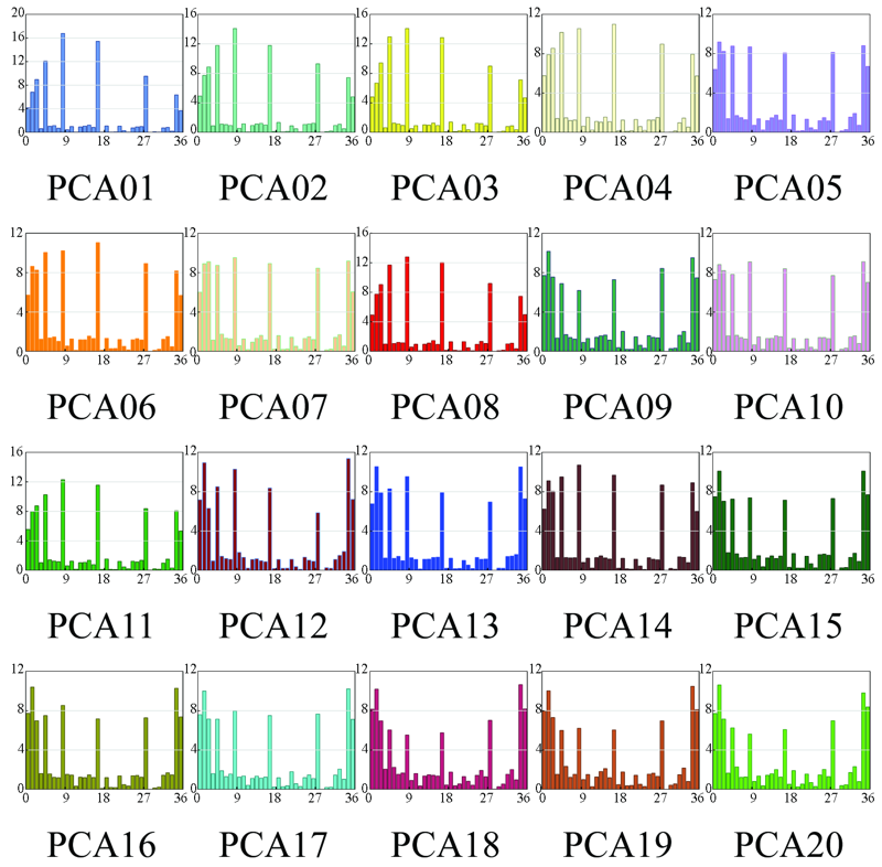
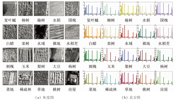
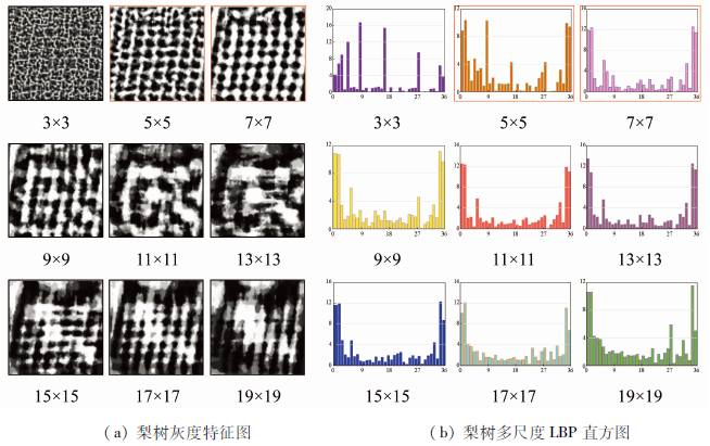
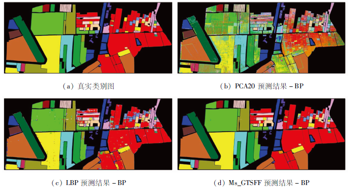
Abstract For the classification of remote sensing images, traditional feature extraction methods frequently ignore their intrinsic properties and the multi-scale local characteristics of the images. As a result, only a small amount of image information can be acquired. Given this, this study proposed a model of multi-scale gray level and texture feature fusion (Ms_GTSFF ) for the feature extraction of remote sensing images, and the extraction steps are as follows. Firstly, extract the gray-level features of the images at different scales. Then obtain the local texture features of the images using the local binary pattern (LBP) algorithm and meanwhile, obtain the image features of a larger receptive field using a multi-scale method. Afterward, obtain the gray-level attributes corresponding to various codes using the obtained multi-scale LBP histograms. Finally, code and fuse multi-scale feature information obtained from the above steps to constitute the Ms_GTSFF feature extraction model, to which multiple machine learning classifiers are connected for classification and recognition. Taking the aerial hyperspectral remote sensing images of Xiongan New Area (Matiwan Village) as the test dataset, the feature extraction and classification tests were performed following the data preprocessing by blocks. The classification accuracy was up to 99.44%, indicating a great improvement in the recognition capability compared with traditional methods. This verified the effectiveness of the proposed model in enhancing the feature extraction capability and improving the classification and reorganization performance of remote sensing images.
|
| Keywords
Hyperspectral remote sensing
multi-scale characteristic
gray-level attribute feature
local binary pattern
feature fusion
|
|
|
|
Issue Date: 24 September 2021
|
|
|
| [1] |
滕文秀, 王妮, 陈泰生, 等. 基于深度对抗域适应的高分辨率遥感影像跨域分类[J]. 激光与光电子学进展, 2019, 56(11):236-246.
|
| [1] |
Teng W X, Wang N, Chen T S, et al. Deep adversarial domain adaptation method for cross-domain classification in high-resolution remote sensing images[J]. Laser & Optoelectronics Progress, 2019, 56(11):236-246.
|
| [2] |
董蕴雅, 张倩. 基于CNN的高分遥感影像深度语义特征提取研究综述[J]. 遥感技术与应用, 2019, 34(1):1-11.
|
| [2] |
Dong Y Y, Zhang Q. A survey of depth semantic feature extraction of high-resolution remote sensing images based on CNN[J]. Remote Sensing Technology and Application, 2019, 34(1):1-11.
|
| [3] |
Yang Y, Newsam S. Comparing SIFT descriptors and Gabor texture features for classification of remote sensed imagery[C]. 2008 15th IEEE International Conference on Image Processing,San Diego,CA, 2008:1852-1855.doi: 10.1109/ICIP.2008.4712139.
doi: 10.1109/ICIP.2008.4712139
|
| [4] |
Dos Santos J A, Penatti,O A B, Torres R D S. Evaluating the potential of texture and color descriptors for remote sensing image retrieval and classification[C]. VISAPP 2010-Proceedings of the International Conference on Computer Vision Theory and Applications, 2010(2):203-208.
|
| [5] |
Chen C, Zhang B, Su H, et al. Land-use scene classification using multi-scale completed local binary patterns[J]. Signal,Image& Video Processing, 2016, 10(4):745-752.
|
| [6] |
Luo B, Jiang S J, Zhang L P. Indexing of remote sensing images with different resolutions by multiple features[J]. IEEE Journal of Selected Topics in Applied Earth Observations and Remote Sensing, 2013, 6(4):1899-1912.
doi: 10.1109/JSTARS.4609443
url: https://ieeexplore.ieee.org/xpl/RecentIssue.jsp?punumber=4609443
|
| [7] |
Lecun Y, Bottou L. Gradient-based learning applied to document recognition[J]. Proceedings of the IEEE, 1998, 86(11):2278-2324.
doi: 10.1109/5.726791
url: http://ieeexplore.ieee.org/document/726791/
|
| [8] |
Zhong Y F, Fei F, Zhang L P. Large patch convolutional neural networks for the scene classification of high spatial resolution imagery[J]. Journal of Applied Remote Sensing, 2016, 10(2):025006.
doi: 10.1117/1.JRS.10.025006
url: http://remotesensing.spiedigitallibrary.org/article.aspx?doi=10.1117/1.JRS.10.025006
|
| [9] |
Hu F, Xia G S, Hu J w, et al. Transferring deep convolutional neural networks for the scene classification of high-resolution remote sensing imagery[J]. Remote Sensing, 2015, 7(11):14680-14707.
doi: 10.3390/rs71114680
url: http://www.mdpi.com/2072-4292/7/11/14680
|
| [10] |
许夙晖, 慕晓冬, 赵鹏, 等. 利用多尺度特征与深度网络对遥感影像进行场景分类[J]. 测绘学报, 2016, 45(7):834-840.
|
| [10] |
Xu S H, Mu X D, Zhao P, et al. Scene classification of remote sensing image based on multi-scale feature and deep neural network[J]. Acta Geodaetica et Cartographica Sinica, 2016, 45(7):834-840.
|
| [11] |
Li E, Xia J, Du P, et al. Integrating multilayer features of convolutional neural networks for remote sensing scene classification[J]. IEEE Transactions on Geosience & Remote Sensing, 2017(10):1-13.
|
| [12] |
Wang G L, Fan B, Xiang S M, et al. Aggregating rich hierarchical features for scene classification in remote sensing imagery[J]. IEEE Journal of Selected Topics in Applied Earth Observations and Remote Sensing, 2017, 10(9):4104-4115.
doi: 10.1109/JSTARS.4609443
url: https://ieeexplore.ieee.org/xpl/RecentIssue.jsp?punumber=4609443
|
| [13] |
Ojala T, Pietikäinen M, Mäenpää T. Multi-resolution gray-scale and rotation invariant texture classification with local binary patterns[J]. IEEE Transactions on Pattern Analysis & Machine Intelligence, 2002, 24(7):971-987.doi: 10.1109/TPAMI.2002.1017623
doi: 10.1109/TPAMI.2002.1017623
|
| [14] |
Lee S W, Li S Z. Face detection based on multi-block LBP representation[C]// Advances in Biometrics,International Conference,Icb,Seoul,Korea,August.DBLP, 2007:11-18.
|
| [15] |
王家臣, 李良晖, 杨胜利. 不同照度下煤矸图像灰度及纹理特征提取的实验研究[J]. 煤炭学报, 2018, 43(11):3051-3061.
|
| [15] |
Wang J C, Li L H, Yang S L. Experimental study on gray and texture features extraction of coal and gangue image under different illuminance[J]. Journal of China Coal Society, 2018, 43(11):3051-3061.
|
| [16] |
岑奕, 张立福, 张霞, 等. 雄安新区马蹄湾村航空高光谱遥感影像分类数据集[J]. 遥感学报, 2020, 24(11):1299-1306.
|
| [16] |
Cen Y, Zhang L F, Zhang X, et al. Aerial hyperspectral remote sensing classification dataset of Xiongan New Area (Matiwan Village)[J]. Journal of Remote Sensing (Chinese), 2020, 24(11):1299-1306.
|
|
Viewed |
|
|
|
Full text
|
|
|
|
|
Abstract
|
|
|
|
|
Cited |
|
|
|
|
| |
Shared |
|
|
|
|
| |
Discussed |
|
|
|
|
 2021,
Vol. 33
2021,
Vol. 33