|
|
 |
|

|
|
|
Application of random forest and Sentinel-1/2 in the information extraction of impervious layers in Dongying City |
LIU Chunting1( ), FENG Quanlong2, JIN Dingjian3, SHI Tongguang1, LIU Jiantao1(), ZHU Mingshui1 ), FENG Quanlong2, JIN Dingjian3, SHI Tongguang1, LIU Jiantao1(), ZHU Mingshui1 |
1. School of Surveying and Geo-Informatics, Shandong Jianzhu University, Jinan 250101, China
2. College of Land Science and Technology, China Agriculture University, Beijing 100083, China
3. China Aero Geophysical Survey & Remote Sensing Center for Natural Resources, Beijing 100083, China |
|
|
|
|
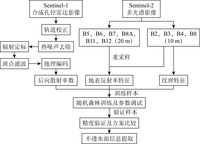
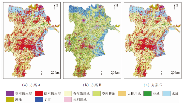
Abstract An impervious layer is an important indicator of human activities. Timely and accurate information of impervious layers is of great significance for the protection of the ecological environment. Taking the Yellow River Delta (Dongying City) as the study area, this study explores a novel extraction method of impervious layers by combining the random forest classification with Sentinel-1/2 data. According to comparative experiments, the confusion between dark and light impervious layers and bare soil can be reduced through the combination of the random forest algorithm with surface reflectance characteristics, texture characteristics, and backscatter coefficient, thus effectively improving the estimation accuracy of impervious layers (overall accuracy: 93.37%, Kappa coefficient: 0.925 8). The results of this study reveal that the random forest algorithm combined with Sentinel-1/2 data is a promising approach in the information extraction of impervious layers, which will provide a reference for the remote sensing monitoring of the Yellow River Delta through the integration of multi-source data.
|
| Keywords
Dongying City
impervious layer
Sentinel-2
Sentinel-1
texture
random forest
|
|
|
|
Corresponding Authors:
LIU Jiantao
E-mail: ctliu96@163.com;liujiantao18@sdjzu.edu.cn
|
|
Issue Date: 24 September 2021
|
|
|
| [1] |
Arnold L C, Gibbons C J. Impervious surface coverage:The emergence of a key environmental indicator[J]. Journal of The American Planning Association, 1996, 62(2):243-258.
doi: 10.1080/01944369608975688
url: http://www.tandfonline.com/doi/abs/10.1080/01944369608975688
|
| [2] |
Leinenkugel P, Esch T, Kuenzer C. Settlement detection and impervious surface estimation in the Mekong Delta using optical and SAR remote sensing data[J]. Remote Sensing of Environment, 2011, 115(12):3007-3019.
doi: 10.1016/j.rse.2011.06.004
url: https://linkinghub.elsevier.com/retrieve/pii/S0034425711002288
|
| [3] |
Weng Q H, Hu X F. Medium spatial resolution satellite imagery for estimating and mapping urban impervious surfaces using LSMA and ANN[J]. IEEE Transactions on Geoscience and Remote Sensing, 2008, 46(8):2397-2406.
doi: 10.1109/TGRS.2008.917601
url: http://ieeexplore.ieee.org/document/4559748/
|
| [4] |
Liu Z H, Wang Y L, Li Z G, et al. Impervious surface impact on water quality in the process of rapid urbanization in Shenzhen,China[J]. Environmental Earth Sciences, 2013, 68(8):2365-2373.
doi: 10.1007/s12665-012-1918-2
url: http://link.springer.com/10.1007/s12665-012-1918-2
|
| [5] |
Ma Q, He C Y, Wu J G, et al. Quantifying spatiotemporal patterns of urban impervious surfaces in China:An improved assessment using nighttime light data[J]. Landscape and Urban Planning, 2014, 130:36-49.
doi: 10.1016/j.landurbplan.2014.06.009
url: https://linkinghub.elsevier.com/retrieve/pii/S0169204614001510
|
| [6] |
Ridd M K. Exploring a V-I-S (vegetation-impervious surface-soil) model for urban ecosystem analysis through remote sensing:Comparative anatomy for citiest[J]. International Journal of Remote Sensing, 1995, 16(12):2165-2185.
doi: 10.1080/01431169508954549
url: https://www.tandfonline.com/doi/full/10.1080/01431169508954549
|
| [7] |
Wu C, Murray A T. Estimating impervious surface distribution by spectral mixture analysis[J]. Remote Sensing of Environment, 2003, 84(4):493-505.
doi: 10.1016/S0034-4257(02)00136-0
url: https://linkinghub.elsevier.com/retrieve/pii/S0034425702001360
|
| [8] |
周存林, 徐涵秋. 福州城区不透水面的光谱混合分析与识别制图[J]. 中国图象图形学报, 2007(5):875-881.
|
| [8] |
Zhou C L, Xu H Q. A spectral mixture analysis and mapping of impervious surfaces in built-up land of Fuzhou City[J]. Journal of Image Graphics, 2007(5):875-881.
|
| [9] |
Carlson T N, Arthur S T. The impact of land use-land cover changes due to urbanization on surface microclimate and hydrology:A satellite perspective[J]. Global & Planetary Change, 2000, 25(1):49-65.
|
| [10] |
徐涵秋. 一种快速提取不透水面的新型遥感指数[J]. 武汉大学学报(信息科学版), 2008(11):1150-1153.
|
| [10] |
Xu H Q. A new remote sensing index for fastly extracting impervious surface information[J]. Geomatics and Information Science of Wuhan University, 2008(11):1150-1153.
|
| [11] |
Liu C, Shao Z, Chen M, et al. MNDISI:A multi-source composition index for impervious surface area estimation at the individual city scale[J]. Remote Sensing Letters, 2013, 4(8):803-812.
doi: 10.1080/2150704X.2013.798710
url: http://www.tandfonline.com/doi/abs/10.1080/2150704X.2013.798710
|
| [12] |
廖明生, 江利明, 林珲, 等. 基于CART集成学习的城市不透水层百分比遥感估算[J]. 武汉大学学报(信息科学版), 2007(12):1099-1102.
|
| [12] |
Liao M S, Jiang L M, Lin H, et al. Estimating urban impervious surface percent using boosting as a refinement of CART analysis[J]. Geomatics and Information Science of Wuhan University, 2007(12):1099-1102.
|
| [13] |
李晓宁, 张友静, 佘远见, 等. CART集成学习方法估算平原河网区不透水面覆盖度[J]. 国土资源遥感, 2013, 25(4):174-179.doi: 10.6046/gtzyyg.2013.04.28.
doi: 10.6046/gtzyyg.2013.04.28
|
| [13] |
Li X N, Zhang Y J, She Y J, et al. Estimation of impervious surface percentage of river network regions using an ensemble leaning of CART analysis[J]. Remote Sensing for Land and Resources, 2013, 25(4):174-179.doi: 10.6046/gtzyyg.2013.04.28.
doi: 10.6046/gtzyyg.2013.04.28
|
| [14] |
Sung C Y, Yi Y J, Li M H. Impervious surface regulation and urban sprawl as its unintended consequence[J]. Land Use Policy, 2013, 32:317-323.
doi: 10.1016/j.landusepol.2012.10.001
url: https://linkinghub.elsevier.com/retrieve/pii/S0264837712001895
|
| [15] |
程熙, 沈占锋, 骆剑承, 等. 利用混合光谱分解与SVM估算不透水面覆盖率[J]. 遥感学报, 2011, 15(6):1228-1241.
|
| [15] |
Cheng X, Shen Z F, Luo J C, et al. Estimation impervious surface based on comparison of spectral mixture analysis and support vector machine methods[J]. Remote Sensing, 2011, 15(6):1228-1241.
|
| [16] |
Sun Z C, Guo H D, Li X W, et al. Estimating urban impervious surfaces from Landsat 5 TM imagery using multilayer perceptron neural network and support vector machine[J]. Journal of Applied Remote Sensing, 2011, 5(1):053501.
doi: 10.1117/1.3539767
url: http://remotesensing.spiedigitallibrary.org/article.aspx?doi=10.1117/1.3539767
|
| [17] |
刘莹, 孟庆岩, 王永吉, 等. 基于特征优选与支持向量机的不透水面覆盖度估算方法[J]. 地理与地理信息科学, 2018, 34(1):24-31.
|
| [17] |
Liu Y, Meng Q Y, Wang Y J, et al. A method for estimating impervious surface percentage based on feature optimization and SVM[J]. Geography and Geo-Information Science, 2018, 34(1):24-31.
|
| [18] |
骆成凤. 遗传算法优化的BP神经网络城市不透水层百分比估算[J]. 测绘科学, 2011, 36(1):48-50.
|
| [18] |
Luo C F. Estimating urban impervious surface percentage with BP neural network based on genetic algorithm[J]. Science of Surveying and Mapping, 2011, 36(1):48-50.
|
| [19] |
Hu X F, Weng Q H. Estimating impervious surfaces from medium spatial resolution imagery using the self-organizing map and multi-layer perceptron neural networks[J]. Remote Sensing of Environment, 2009, 113(10):2089-2102.
doi: 10.1016/j.rse.2009.05.014
url: https://linkinghub.elsevier.com/retrieve/pii/S0034425709001655
|
| [20] |
Zhang Y Z, Zhang H S, Lin H, et al. Improving the impervious surface estimation with combined use of optical and SAR remote sensing images[J]. Remote Sensing of Environment, 2014, 141:155-167.
doi: 10.1016/j.rse.2013.10.028
url: https://linkinghub.elsevier.com/retrieve/pii/S0034425713003969
|
| [21] |
Shao Z F, Fu H Y, Fu P, et al. Mapping urban impervious surface by fusing optical and SAR data at the decision level[J]. Remote Sensing, 2016, 8(11),945-965.
doi: 10.3390/rs8110945
url: http://www.mdpi.com/2072-4292/8/11/945
|
| [22] |
Guo H D, Yang H N, Sun Z C, et al. Synergistic use of optical and PolSAR imagery for urban impervious surface estimation[J]. Photogrammetric Engineering and Remote Sensing, 2014, 80(1):91-102.
doi: 10.14358/PERS.80.1.91
url: http://openurl.ingenta.com/content/xref?genre=article&issn=0099-1112&volume=80&issue=1&spage=91
|
| [23] |
Deng C B, Wu C S. Examining the impacts of urban biophysical compositions on surface urban heat island:A spectral unmixing and thermal mixing approach[J]. Remote Sensing of Environment, 2013, 131:262-274.
doi: 10.1016/j.rse.2012.12.020
url: https://linkinghub.elsevier.com/retrieve/pii/S0034425712004865
|
| [24] |
Weng Q H. Remote sensing of impervious surfaces in the urban areas:Requirements,methods,and trends[J]. Remote Sensing of Environment, 2012, 117:34-49.
doi: 10.1016/j.rse.2011.02.030
url: https://linkinghub.elsevier.com/retrieve/pii/S0034425711002811
|
| [25] |
Zhang Y Z, Zhang H S, Lin H. Improving the impervious surface estimation with combined use of optical and SAR remote sensing images[J]. Remote Sensing of Environment, 2014, 141:155-167.
doi: 10.1016/j.rse.2013.10.028
url: https://linkinghub.elsevier.com/retrieve/pii/S0034425713003969
|
| [26] |
唐廷元, 付波霖, 何索云, 等. 基于GF-1和Sentinel-1A的漓江流域典型地物信息提取[J]. 遥感技术与应用, 2020, 35(2):448-457.
|
| [26] |
Tang T Y, Fu B L, He S Y, et al. Identification of typical land features in the Lijiang River Basin with fusion optics and Radar[J]. Remote Sensing Technology and Application, 2020, 35(2):448-457.
|
| [27] |
张鸿生, 林殷怡, 王挺, 等. 融合光学与雷达遥感数据的城市不透水面提取方法[J]. 地理与地理信息科学, 2018, 34(3):39-46.
|
| [27] |
Zhang H S, Lin Y Y, Wang T, et al. Fusing optical and SAR remote sensing data for urban impervious surface estimation[J]. Geography and Geo-Information Science, 2018, 34(3):39-46.
|
| [28] |
Masound M, Bahram S, Fariba M, et al. Random forest wetland classification using ALOS-2L-band,RADARSAT-2C-band and TerraSAR-X imagery[J]. ISPRS Journal of Photogrammetry and Remote Sensing, 2017, 130:13-31.
doi: 10.1016/j.isprsjprs.2017.05.010
url: https://linkinghub.elsevier.com/retrieve/pii/S0924271617300850
|
| [29] |
Zhang H S, Zhang Y Z, Lin H. A comparison study of impervious surfaces estimation using optical and SAR remote sensing images[J]. International Journal of Applied Earth Observation and Geoinformation, 2012, 18:148-156.
doi: 10.1016/j.jag.2011.12.015
url: https://linkinghub.elsevier.com/retrieve/pii/S0303243412000086
|
| [30] |
Zhang H S, Li J, Wang T, et al. A manifold learning approach to urban land cover classification with optical and Radar data[J]. Landscape and Urban Planning, 2018, 172:11-24.
doi: 10.1016/j.landurbplan.2017.12.009
url: https://linkinghub.elsevier.com/retrieve/pii/S0169204618300021
|
| [31] |
Zhang Y Z, Zhang H S, Hui L, et al. Improving the impervious surface estimation with combined use of optical and SAR remote sensing images[J]. Remote Sensing of Environment, 2014, 141:155-167.
doi: 10.1016/j.rse.2013.10.028
url: https://linkinghub.elsevier.com/retrieve/pii/S0034425713003969
|
| [32] |
Zhang H S, Lin H, Li Y, et al. Mapping urban impervious surface with dual-polarimetric SAR data:An improved method[J]. Landscape and Urban Planning, 2016, 151:55-63.
doi: 10.1016/j.landurbplan.2016.03.009
url: https://linkinghub.elsevier.com/retrieve/pii/S0169204616000426
|
| [33] |
陈凯, 肖能文, 王备新, 等. 黄河三角洲石油生产对东营湿地底栖动物群落结构和水质生物评价的影响[J]. 生态学报, 2012, 32(6):1970-1978.
|
| [33] |
Chen K, Xiao N W, Wang B X, et al. The effects of petroleum on water quality bio-assessment and benthic macro-invertbrate communities in the Yellow River Delta wetland,Dongying[J]. Acta Ecologica Sinica, 2012, 32(6):1970-1978.
doi: 10.5846/stxb
url: http://www.ecologica.cn/
|
| [34] |
丁彤彤, 周廷刚, 朱晓波, 等. 基于卫星遥感影像的黄河三角洲湿地景观格局动态变化研究——以东营市为例[J]. 西南师范大学学报(自然科学版), 2016, 41(04):52-57.
|
| [34] |
Ding T T, Zhou T G, Zhu X B, et al. On dynamic changes of wetland in Yellow River Delta with remote sensing images:A case study of Dongying City[J]. Southwest Normal University(Natural Science Edition), 2016, 41(4):52-57.
|
| [35] |
秦天天, 齐伟, 徐柏琪, 等. 基于RV指数的道路对黄河三角洲地区土地利用的影响:以东营市为例[J]. 河北农业科学, 2011, 15(11):67-72.
|
| [35] |
Qin T T, Qi W, Xu B Q, et al. Impacts of road on land use based on RV index in Yellow River Delta:A case in Dongying City[J]. Heibei Agricultural Sciences, 2011, 15(11):67-72.
|
| [36] |
刘翠翠. 黄河三角洲湿地生态修复工程效果研究[D]. 济南:山东师范大学, 2013.
|
| [36] |
Liu C C. The study of the wetland restoration engineering effect in Yellow River Delta[D]. Jinan:Shandong Normal University, 2013.
|
| [37] |
侯学会, 李新华. 黄河三角洲自然保护区1992—2010年土地覆被变化分析[J]. 亚热带植物科学, 2015, 44(4):309-314.
|
| [37] |
Hou X H, Li X H. Characteristics of land cover change in the Yellow River estuary nature reserve from 1992 to 2010[J]. Subtropical Plant Science, 2015, 44(4):309-314.
|
| [38] |
Lee J S. Digital image smoothing and the sigma filter[J]. Computer Vision Graphics and Image Processing, 1983, 24:255-269.
doi: 10.1016/0734-189X(83)90047-6
url: https://linkinghub.elsevier.com/retrieve/pii/0734189X83900476
|
| [39] |
Lopes A, Touzi R, Nezry E. Adaptive speckle filters and scene heterogeneity[J]. IEEE Transactions on Geoscience and Remote Sensing, 1990, 28:992-1000.
doi: 10.1109/36.62623
url: http://ieeexplore.ieee.org/document/62623/
|
| [40] |
Xie H, Pierce L E, Ulaby F T. SAR speckle reduction using wavelet denoising and Markov random field modeling[J]. IEEE Transactions on Geoscience and Remote Sensing, 2002, 40:2196-2212.
doi: 10.1109/TGRS.2002.802473
url: http://ieeexplore.ieee.org/document/1105905/
|
| [41] |
Feng Q L, Liu J T, Gong J H. UAV remote sensing for urban vegetation mapping using random forest and texture analysis[J]. Remote sensing, 2015, 7(1):1074-1094.
doi: 10.3390/rs70101074
url: http://www.mdpi.com/2072-4292/7/1/1074
|
| [42] |
Dell’Acqua F, Gamba P. Texture-based characterization of urban environments on satellite SAR images[J]. IEEE Transactions on Geoscience and Remote Sensing, 2003, 41:153-159.
doi: 10.1109/TGRS.2002.807754
url: http://ieeexplore.ieee.org/document/1183703/
|
| [43] |
Stasolla M, Gamba P. Spatial indexes for the extraction of formal and informal human settlements from high-resolution SAR images[J]. IEEE Journal of Selected Topics in Applied Earth Observations and Remote Sensing, 2008, 1(2):98-106.
doi: 10.1109/JSTARS.4609443
url: https://ieeexplore.ieee.org/xpl/RecentIssue.jsp?punumber=4609443
|
| [44] |
Feng Q L, Liu J T, Gong J H. Urban flood mapping based on unmanned aerial vehicle remote sensing and random forest classifier:A case of Yuyao,China[J]. Water, 2015, 7(4):1437-1455.
doi: 10.3390/w7041437
url: http://www.mdpi.com/2073-4441/7/4/1437
|
| [45] |
Puissant A, Hirsch J, Weber C. The utility of texture analysis to improve per-pixel classification for high to very high spatial resolution imagery[J]. International Journal of Remote Sensing, 2005, 26:733-745.
doi: 10.1080/01431160512331316838
url: https://www.tandfonline.com/doi/full/10.1080/01431160512331316838
|
| [46] |
Breiman L. Random forests[J]. Machine Learning, 2001, 45(1):5-32.
doi: 10.1023/A:1010933404324
url: http://link.springer.com/10.1023/A:1010933404324
|
| [47] |
蒲东川. 多源卫星遥感数据驱动的城市不透水面提取[D]. 长春:吉林大学, 2020.
|
| [47] |
Pu D C. Urban impervious surface extraction driven by multi-source satellite remote sensing data[D]. Changchun:Jilin University, 2020.
|
| [48] |
蔡博文, 王树根, 王磊, 等. 基于深度学习模型的城市高分辨率遥感影像不透水面提取[J]. 地球信息科学学报, 2019, 21(9):1420-1429.
doi: 10.12082/dqxxkx.2019.180679
|
| [48] |
Cai B W, Wang S G, Wang L, et al. Extraction of urban impervious surface from high-resolution remote sensing imagery based on deep learning[J]. Geo-Information Science, 2019, 21(9):1420-1429.
|
| [49] |
邵振峰, 张源, 周伟琪, 等. 基于测绘卫星影像的城市不透水面提取[J]. 地理空间信息, 2016, 14(7):1-6.
|
| [49] |
Shao Z F, Zhang Y, Zhou W Q, et al. Extraction of urban impervious surface based on high resolution remote sensing image[J]. Geospatial Information, 2016, 14(7):1-6.
|
| [50] |
朱德海, 刘逸铭, 冯权泷, 等. 基于GEE的山东省近30年农业大棚时空动态变化研究[J]. 农业机械学报, 2020, 51(1):168-175.
|
| [50] |
Zhu D H, Liu Y M, Feng Q L, et al. Spatial-temporal dynamic changes of agricultural greenhouses in Shandong Province in recent 30 years based on Google Earth Engine[J]. Transactions of the Chinese Society for Agricultural Machinery, 2020, 51(1):168-175.
|
| [51] |
Rodriguez-Galiano V F, Ghimire B, Rogan J, An assessment of the effectiveness of a random forest classifier for land-cover classification[J]. ISPRS Journal of Photogrammetry and Remote Sensing, 2012, 67:93-104.
doi: 10.1016/j.isprsjprs.2011.11.002
url: https://linkinghub.elsevier.com/retrieve/pii/S0924271611001304
|
|
Viewed |
|
|
|
Full text
|
|
|
|
|
Abstract
|
|
|
|
|
Cited |
|
|
|
|
| |
Shared |
|
|
|
|
| |
Discussed |
|
|
|
|
 2021,
Vol. 33
2021,
Vol. 33