Please wait a minute...
 
Remote Sensing for Natural Resources    2021, Vol. 33 Issue (3) : 156-163     DOI: 10.6046/zrzyyg.2020317
|
Remote sensing-based mineralized alteration information extraction and prospecting prediction of the Beiya gold deposit, Yunnan Province
WEI Yingjuan1(), LIU Huan2
1. Land Satellite Remote Sensing Application Center, Beijing 100048, China
2. Institute of Mineral Resources, Chinese Academy of Geological Sciences, Beijing 100037, China
Download: PDF(7760 KB)   HTML
Export: BibTeX | EndNote | Reference Manager | ProCite | RefWorks    
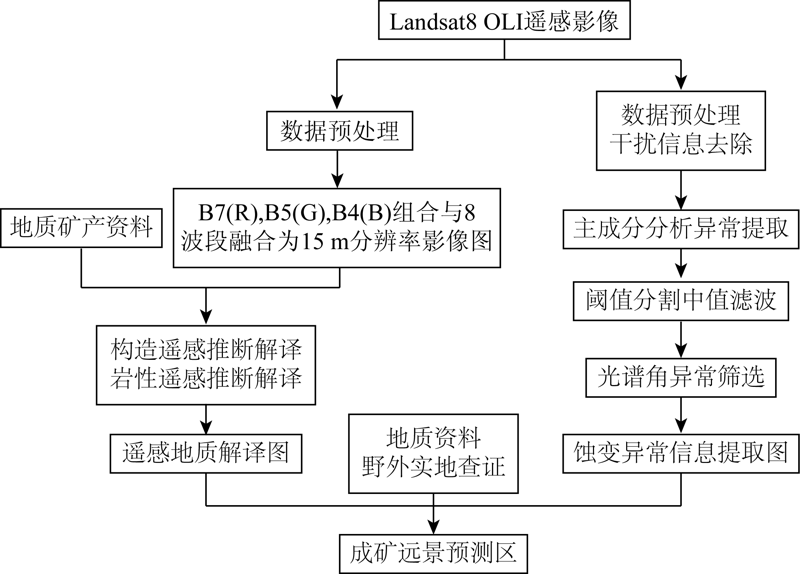
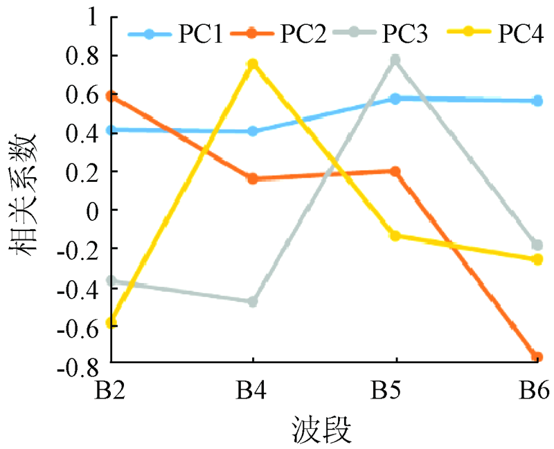
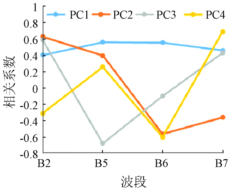
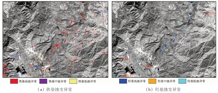
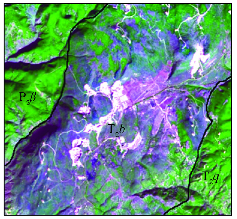
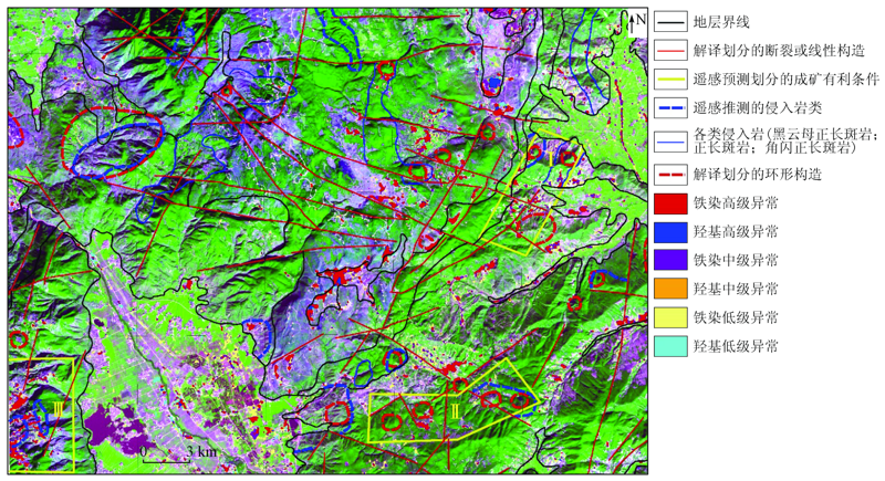
Abstract  

The identification and extraction of mineralized alteration information play an important role in the ore prospecting using remote sensing technology. Taking the Beiya gold polymetallic deposit as an example, this study designed an alteration information extraction scheme using the principal component analysis technique according to Landsat8 OLI data and the spectral characteristics related to mineral alteration. Specifically, the extraction scheme consists of the removal of interference information (vegetation, water, and shadows), extraction of abnormal information, anomaly gradation, median filtering, and anomaly screening successively. According to the anomaly information extracted, as well as geological interpretation of remote sensing data (lithology and structures) and field surveys, three prospecting areas were delineated in the study area. This will provide basic data and decision-making bases for the ore prospecting in the Beiya area.

Keywords alteration anomaly information extraction      principal component analysis      remote sensing      geological interpretation      ore prospecting     
ZTFLH:  TP79  
Issue Date: 24 September 2021
Service
E-mail this article
E-mail Alert
RSS
Articles by authors
Yingjuan WEI
Huan LIU
Cite this article:   
Yingjuan WEI,Huan LIU. Remote sensing-based mineralized alteration information extraction and prospecting prediction of the Beiya gold deposit, Yunnan Province[J]. Remote Sensing for Natural Resources, 2021, 33(3): 156-163.
URL:  
https://www.gtzyyg.com/EN/10.6046/zrzyyg.2020317     OR     https://www.gtzyyg.com/EN/Y2021/V33/I3/156
Fig.1  Flow chart of remote sensing anomaly information extraction, geological interpretation and prospecting prediction of Beiya gold polymetallic deposit
Fig.2  PCA[2,4,5,6] principal component eigenvector matrix
Fig.3  PCA[2,5,6,7] principal component eigenvector matrix
Fig.4  Distribution map of iron-stained and hydroxyl alteration anomalies in Beiya area
Fig.5  Triassic (T2b) and surrounding stratigraphic images
Fig.6  Image interpretation signs of typical Permian basalt (P2β)
Fig.7  Image interpretation mark map of typical linear structure and field photo of fault fracture structure fault breccia
Fig.8  Image interpretation sign of typical circular structure
Fig.9  Prospective map of remote sensing mineralization in Beiya area
Fig.10  Yellow-brown iron argillaceous film in the fissure
Fig.11  Purple-red iron film (limonite mineralization) and clay mineralization
Fig.12  Field photos of grayish green muddy and iron disseminated and light yellow-dark brown basalt limonite mineralization
[1] 张斌, 郑燕, 李清云, 等. 基于OLI遥感数据的遥感异常信息提取方法[J]. 河南理工大学学报, 2017, 36(3):47-53.
[1] Zhang B, Zheng Y, Li Q Y, et al. Remote sensing anomaly information extraction method based on OLI remote sensing data[J]. Journal of Henan University of Technology, 2017, 36(3):47-53.
[2] 陈爱兵, 孙彩霞, 姜华, 等. 北衙金矿综合信息成矿预测[J]. 地质与勘探, 2011, 47(4):663-641.
[2] Chen A B, Sun C X, Jiang H, et al. Comprehensive information and metalorganic prediction of Beiya gold deposit[J]. Geology and Prospecting, 2011, 47(4):663-641.
[3] 杨世瑜, 王瑞雪. 北衙碱性斑岩型金矿床矿床遥感地质综合信息[J]. 昆明理工大学学报, 2002, 27(4):1-5.
[3] Yang S Y, Wang R X. Comprehensive remote sensing geological information of Beiya alkaline porphyry gold deposit[J]. Journal of Kunming University of Science and Technology, 2002, 27(4):1-5.
[4] 陈理, 胡光道, 唐晨. 遥感技术在鹤庆北衙金矿找矿中的应用[J]. 东华理工大学学报, 2011, 34(4):366-373.
[4] Chen L, Hu G D, Tang C. Gold deposits in Heqing from remotely sensed data[J]. Journal of East China Institute of Technology, 2011, 34(4):366-373.
[5] 杨建民, 张玉君, 等. 矿产资源调查评价的现代化技术方法——以ETM+蚀变遥感异常为主导的多元信息矿产评价方法[J]. 矿床地质, 2002, 21(s1):1225-1227.
[5] Yang J M, Zhang Y J, et al. A modern technical method for mineral resources survey and evaluation:A multi-information mineral evaluation method led by ETM+ alteration remote sensing anomalies[J]. Mineral Deposits, 2002, 21(s1):1225-1227.
[6] 姚佛军, 张玉君, 杨建民, 等. 利用ASTER提取德兴斑岩铜矿遥感蚀变分带信息[J]. 矿床地质, 2012, 31(4):881-890.
[6] Yao F J, Zhang Y J, Yang J M, et al. Extracting remote sensing alteration zoning information of Dexing porphyry copper deposit using ASTER[J]. Mineral Deposits, 2012, 31(4):881-890.
[7] 张玉君, 增朝铭. 西藏冈底斯地区斑岩铜矿识别的最佳多光谱遥感异常判据研究[J]. 矿床地质, 2012, 31(4):671-698.
[7] Zhang Y J, Zeng C M. Study on the best multi-spectral remote sensing anomaly criterion for the identification of porphyry copper deposits in Gangdise area,Tibet[J]. Mineral Deposits, 2012, 31(4):671-698.
[8] 张国荣, 芦青山, 费一清. ETM+数据在甘肃省肃北县黑刺沟一带蚀变遥感异常信息提取中的应用[J]. 大地构造与成矿学, 2010, 34(3):386-390.
[8] Zhang G R, Lu Q S, Fei Y Q. Application of ETM+ data in the extraction of alteration remote sensing anomaly information in Heicigou,Subei County,Gansu Province[J]. Tectonics and Metallogeny, 2010, 34(3):386-390.
[9] 费一清, 李永庆. 基于ETM数据的蚀变遥感异常信息提取及成矿区预测研究——以甘肃党和南山地区为例[J]. 遥感技术与应用, 2011, 26(4):482-488.
[9] Fei Y Q, Li Y Q. Alteration remote sensing anomaly information extraction and metallogenic area prediction based on ETM data:Taking Gansu Dang and Nanshan area as an example[J]. Remote Sensing Technology and Application, 2011, 26(4):482-488.
[10] 荆凤, 陈建平. 矿化蚀变信息的遥感提取方法综述[J]. 遥感信息, 2005,(2):62-65,57.
[10] Jing F, Chen J P. Summary of remote sensing extraction methods of mineralization alteration information[J]. Remote Sensing Information, 2005,(2):62-65,57.
[11] 王一伟, 谢启兴, 何雪峰, 等. 内蒙北山阿木乌苏遥感异常信息提取及成矿预测[J]. 四川地质学报, 2015, 35(1):151-156.
[11] Wang Y W, Xie Q X, He X F, et al. Remote sensing anomaly information extraction and mineralization prediction of Amuwusu,Beishan,Inner Mongolia[J]. Journal of Sichuan Geology, 2015, 35(1):151-156.
[12] 付洪波. 基于光谱角制图法的遥感异常信息提取[J]. 测绘与空间地理信息, 2011, 34(6):82-84.
[12] Fu H B. Remote sensing anomaly information extraction based on spectral angle mapping method[J]. Surveying and Spatial Geographic Information, 2011, 34(6):82-84.
[1] NIU Xianghua, HUANG Wei, HUANG Rui, JIANG Sili. A high-fidelity method for thin cloud removal from remote sensing images based on attentional feature fusion[J]. Remote Sensing for Natural Resources, 2023, 35(3): 116-123.
[2] DONG Ting, FU Weiqi, SHAO Pan, GAO Lipeng, WU Changdong. Detection of changes in SAR images based on an improved fully-connected conditional random field[J]. Remote Sensing for Natural Resources, 2023, 35(3): 134-144.
[3] WANG Jianqiang, ZOU Zhaohui, LIU Rongbo, LIU Zhisong. A method for extracting information on coastal aquacultural ponds from remote sensing images based on a U2-Net deep learning model[J]. Remote Sensing for Natural Resources, 2023, 35(3): 17-24.
[4] TANG Hui, ZOU Juan, YIN Xianghong, YU Shuchen, HE Qiuhua, ZHAO Dong, ZOU Cong, LUO Jianqiang. River and lake sand mining in the Dongting Lake area: Supervision based on high-resolution remote sensing images and typical case analysis[J]. Remote Sensing for Natural Resources, 2023, 35(3): 302-309.
[5] YU Hang, AN Na, WANG Jie, XING Yu, XU Wenjia, BU Fan, WANG Xiaohong, YANG Jinzhong. High-resolution remote sensing-based dynamic monitoring of coal mine collapse areas in southwestern Guizhou: A case study of coal mine collapse areas in Liupanshui City[J]. Remote Sensing for Natural Resources, 2023, 35(3): 310-318.
[6] LIANG Jintao, CHEN Chao, ZHANG Zili, LIU Zhisong. A random forest-based method integrating indices and principal components for classifying remote sensing images[J]. Remote Sensing for Natural Resources, 2023, 35(3): 35-42.
[7] WANG Jing, WANG Jia, XU Jiangqi, HUANG Shaodong, LIU Dongyun. Exploring ecological environment quality of typical coastal cities based on an improved remote sensing ecological index: A case study of Zhanjiang City[J]. Remote Sensing for Natural Resources, 2023, 35(3): 43-52.
[8] XU Xinyu, LI Xiaojun, ZHAO Heting, GAI Junfei. Pansharpening algorithm of remote sensing images based on NSCT and PCNN[J]. Remote Sensing for Natural Resources, 2023, 35(3): 64-70.
[9] LIU Li, DONG Xianmin, LIU Juan. A performance evaluation method for semantic segmentation models of remote sensing images considering surface features[J]. Remote Sensing for Natural Resources, 2023, 35(3): 80-87.
[10] FANG He, ZHANG Yuhui, HE Yue, LI Zhengquan, FAN Gaofeng, XU Dong, ZHANG Chunyang, HE Zhonghua. Spatio-temporal variations of vegetation ecological quality in Zhejiang Province and their driving factors[J]. Remote Sensing for Natural Resources, 2023, 35(2): 245-254.
[11] ZHANG Xian, LI Wei, CHEN Li, YANG Zhaoying, DOU Baocheng, LI Yu, CHEN Haomin. Research progress and prospect of remote sensing-based feature extraction of opencast mining areas[J]. Remote Sensing for Natural Resources, 2023, 35(2): 25-33.
[12] MA Shibin, PI Yingnan, WANG Jia, ZHANG Kun, LI Shenghui, PENG Xi. High-efficiency supervision method for green geological exploration based on remote sensing[J]. Remote Sensing for Natural Resources, 2023, 35(2): 255-263.
[13] WANG Ping. Application of thermal infrared remote sensing in monitoring the steel overcapacity cutting[J]. Remote Sensing for Natural Resources, 2023, 35(2): 271-276.
[14] LI Tianchi, WANG Daoru, ZHAO Liang, FAN Renfu. Classification and change analysis of the substrate of the Yongle Atoll in the Xisha Islands based on Landsat8 remote sensing data[J]. Remote Sensing for Natural Resources, 2023, 35(2): 70-79.
[15] DIAO Mingguang, LIU Yong, GUO Ningbo, LI Wenji, JIANG Jikang, WANG Yunxiao. Mask R-CNN-based intelligent identification of sparse woods from remote sensing images[J]. Remote Sensing for Natural Resources, 2023, 35(2): 97-104.
Viewed
Full text


Abstract

Cited

  Shared   
  Discussed   
京ICP备05055290号-2
Copyright © 2017 Remote Sensing for Natural Resources
Support by Beijing Magtech