|
|
 |
|

|
|
|
Surface albedos of different land use types in the Junggar Basin |
DENG Xiaojin1( ), JING Changqing1(), GUO Wenzhang1, Yan Yujiang2, CHEN Chen1 ), JING Changqing1(), GUO Wenzhang1, Yan Yujiang2, CHEN Chen1 |
1. College of Grassland and Environment Sciences, Xinjiang Agricultural University, Key Laboratory of Grassland Resources and Ecology of Xinjiang, Urumqi 830052, China
2. School of Economics and Busines, Xinjiang Agricultural University, Urumqi 830052, China |
|
|
|
|
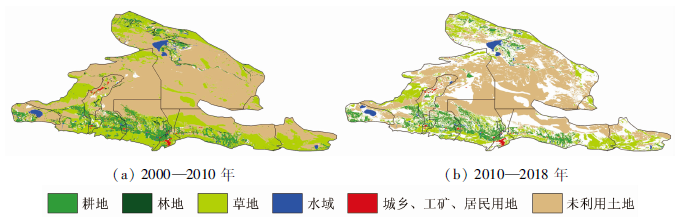
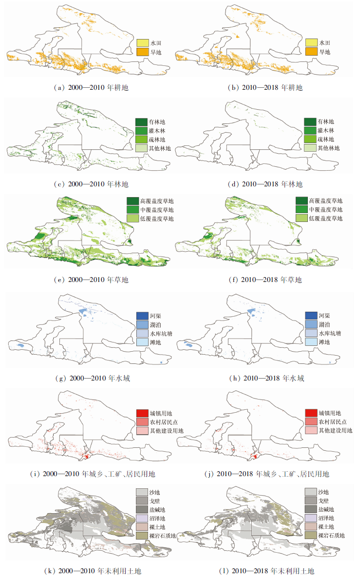
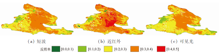
Abstract This study focuses on the surface albedo characteristics of different land use types in the Junggar Basin, aiming to provide a scientific basis for the revealment of the biogeophysical mechanisms of different land use types on a regional scale. Based on the surface albedo data during 2000-2018 obtained through remote sensing inversion and the land use data of 2000, 2010, and 2018, this study analyzed the temporal and spatial variation characteristics and interannual variation trend of the surface albedos for short wave (0.3~2.5 μm), near infrared (0.76~3.0 μm) and visible light (0.35~0.76 μm) of different land use types in the Junggar Basin. It will provide a scientific basis for the understanding of the albedo characteristics of different land use types and reveal the impacts of cover change on climate change on a regional scale. The results are as follows. The surface albedos of different land use types have distinctly different characteristics for different wavebands. The surface albedos of the first- and second-level land use types are in the order of near infrared > short wave > visible light, except for the second-level land use types of lakes and reservoirs. For the interannual change trend, the surface albedos of different land use types for the three bands during 2010—2018 are slightly higher than that during 2000—2010. Moreover, all the first-level land use types in the short waveband during 2010—2018 passed the significance test of p=0.05. The interannual variations of surface albedos of land use types in the Junggar Basin over the past 18 years showed a weak growth trend in terms of the variation rate and were slight and stable on the whole in terms of the rate variation. The results of this study will lay a foundation for the research into the surface spectral radiation and energy balance of the study area.
|
| Keywords
Junggar Basin
surface albedo
land use types
visible light
near-infrared
shortwave
|
|
|
|
Corresponding Authors:
JING Changqing
E-mail: 576762545@qq.com;jingchangqing@126.com
|
|
Issue Date: 24 September 2021
|
|
|
| [1] |
Lawler J J, Lewis J D, Nelson E, et al. Projected land-use change impacts on ecosystem services in the United States[J]. Proceedings of the National Academy of Sciences, 2014, 111(20):7492-7497.
doi: 10.1073/pnas.1405557111
url: http://www.pnas.org/cgi/doi/10.1073/pnas.1405557111
|
| [2] |
刘纪远, 宁佳, 匡文慧. 2010—2015年中国土地利用变化的时空格局与新特征[J]. 地理学报, 2018, 73(5):789-802.
doi: 10.11821/dlxb201805001
|
| [2] |
Liu J Y, Ning J, Kuang W H. Temporal and spatial patterns and new features of land use change in China from 2010 to 2015[J]. Journal of Geographical Sciences, 2018, 73(5):789-802.
|
| [3] |
Betts R A, Falloon P, Goldewijk K K, et al. Biogeophysical effects of land use on climate:Model simulations of radiative forcing and largescale temperature change[J]. Agricul-tural and Forest Meteorology, 2007, 142(2-4):216-233.
|
| [4] |
Prestele R, Arneth A, Bondeau A, et al. Current challenges of implementing anthropogenic land-use and land-cover change in models contributing to climate change assess-ments[J]. Earth System Dynamics, 2017, 8(2):1-28.
doi: 10.5194/esd-8-1-2017
url: https://esd.copernicus.org/articles/8/1/2017/
|
| [5] |
翟俊, 刘荣高, 刘纪远, 等. 1990—2010年中国土地覆被变化引起反照率改变的辐射强迫[J]. 地理学报, 2013, 68(7):875-885.
|
| [5] |
Zhai J, Liu R G, Liu J Y, et al. Radiative forcing over China due to albedo change caused by land cover change during 1990—2010[J]. Acta Geographica Sinica, 2013, 68(7):875-885.
|
| [6] |
Steffen W, Rockström J, Richardson K, et al. Trajectories of the Earth system in the anthropocene[J]. Proceedings of the National Academy of Sciences, 2018, 115(33):8252-8259.
doi: 10.1073/pnas.1810141115
url: http://www.pnas.org/lookup/doi/10.1073/pnas.1810141115
|
| [7] |
Betts R A. Biogeophysical impacts of land use on present-day climate:Near-surface temperature change and radiative forcing[J]. Atmospheric Science Letters, 2000, 2(1-4):39-51.
doi: 10.1006/asle.2001.0023
url: http://doi.wiley.com/10.1006/asle.2001.0023
|
| [8] |
Hansen J, Sato M, Ruedy R. Radiative forcing and climate response[J]. Journal of Geophysical Research, 1997, 102(1997):6831-6864.
doi: 10.1029/96JD03436
url: http://doi.wiley.com/10.1029/96JD03436
|
| [9] |
Brovkin V, Raddatz T, Reick C H, et al. Global biogeophysical interactions between forest and climate[J]. Geophysical Research Letters, 2009, 36(7):251-254.
|
| [10] |
Barnes C A, Roy D P. Radiative forcing over the conterminous united states due to contemporary land cover land use albedo change[J]. Geophysical Research Letters, 2008, 35(9):1-6.
|
| [11] |
Myhre G, Myhre A. Uncertainties in radiative forcing due to surface albedo changes caused by land-use changes[J]. Journal of Climate, 2003, 16(10):1511-1524.
doi: 10.1175/1520-0442(2003)016<1511:UIRFDT>2.0.CO;2
url: http://journals.ametsoc.org/doi/10.1175/1520-0442(2003)016<1511:UIRFDT>2.0.CO;2
|
| [12] |
Myhre G, Kvalevag M M, Schaaf C B. Radiative forcing due to anthropogenic vegetation change based on modis surface albedo data[J]. Geophysical Research Letters, 2005, 32(21):1-4.
|
| [13] |
Davin E L, Noblet-Ducoudré N, Friedlingstein P. Impact of land cover change on surface climate:Relevance of the radiative forcing concept[J]. Geophysical Research Letters, 2007, 34(13):1-5.
|
| [14] |
李振朝, 韦志刚, 文军, 等. 黄土高原典型塬区冬小麦地表辐射平衡各分量特征分析[J]. 太阳能学报, 2009, 30(1):12-18.
|
| [14] |
Li Z C, Wei Z G, Wen J, et al. Analysis of land-surface radiation characteristic in winter-wheat field over the loess plateau mesa in China[J]. Acta Energiae Solaris Sinica, 2009, 30(1):12-18.
|
| [15] |
郑志远, 韦志刚, 李振朝, 等. 敦煌荒漠戈壁地区裸土地表反照率参数化研究[J]. 大气科学, 2014, 38(2):297-308.
|
| [15] |
Zheng Z Y, Wei Z G, Li Z C, et al. Study of parameterization of surface albedo of bare soilover the Gobi desert in the Dunhuang region[J]. Chinese Journal of Atmospheric Sciences, 2014, 38(2):297-308.
|
| [16] |
杨佳希, 李振朝, 韦志刚, 等. 稀疏植被地表分光辐射及其反照率特征研究[J]. 太阳能学报, 2017, 38(3):852-859.
|
| [16] |
Yang J X, Li Z C, Wei Z G, et al. Characteristics of solar spectral radiation and corresponding albedo in sparse vegetation region[J]. Acta Energiac Solaris Sinica, 2017, 38(3):852-859.
|
| [17] |
邹基玲, 季国良. 藏北高原太阳总辐射和地表反射率的分光辐射[J]. 太阳能学报, 1996, 17(12):113-117.
|
| [17] |
Zou J L, Ji G L. The spectral characteristics of global radiation and surface albedo on Northern Tibetan plateau[J]. Acta Energiae Solaris Sinica, 1996, 17(12):113-117.
|
| [18] |
Zheng Z Y, Dong W J, Li Z C, et al. Observational study of surface spectral radiation and corresponding albedo over Gobi,desert,and bare loess surfaces in northwestern China[J]. Journal of Geophysical Research:Atmospheres, 2015, 120(3):883-896.
doi: 10.1002/2014JD022516
url: http://doi.wiley.com/10.1002/2014JD022516
|
| [19] |
郑志远, 韦志刚, 李振朝, 等. 敦煌戈壁秋初太阳分光辐射及其反照率特征[J]. 太阳能学报, 2012, 33(11):1938-1942.
|
| [19] |
Zheng Z Y, Wei Z G, Li Z C, et al. Characteristics of solar spectral radiation and albedo during early autumn in Dunhuangn Gobl[J]. Acta Energlae Solaris Sinica, 2012, 33(11):1938-1942.
|
| [20] |
刘亲亲, 崔耀平, 刘素洁, 等. 中国不同土地利用类型分光辐射地表反照率研究[J]. 遥感技术与应用, 2019, 34(1):46-56.
|
| [20] |
Liu Q Q, Cui Y P, Liu S J, et al. Study on surface albedo of spectral radiation of different land use types in China[J]. Remote Sensing Technology and Application, 2019, 34(1):46-56.
|
| [21] |
许鹏, 新疆草地资源及其应用[M]. 乌鲁木齐: 新疆科技卫生出版社, 1993: 205.
|
| [21] |
Xu P. Grassland resources and its application in Xinjiang[M]. Urumqi: Xinjiang Science and Technology Health Press, 1993: 205.
|
| [22] |
Vermote E F, Kotchenova S Y. MOD09(surface reflectance) user’s guide[EB/OL].(2008-3)[2012-7]. http://modis-sr.ltdri.org.
url: http://modis-sr.ltdri.org
|
| [23] |
Wang K, Liu J, Zhou X, et al. Validation of the MODIS global land surface albedo product using ground measurements in a semidesert region on the Tibetan Plateau[J]. Journal of Geophysical Research, 2004, 109(D5):1-9.
|
| [24] |
Lucht W, Schaaf C B, Strahler A H. An algorithm for the retrieval of albedo from space using semiempirical BRDF models[J]. IEEE Transactions on Geoscience & Remote Sensing, 2000, 38(2):977-997.
|
| [25] |
Liang S L. Validating MODIS land surface reflectance and albedo products:Methods and preliminary results[J]. Remote Sensing of Environment, 2002, 83(1-2):149-162.
doi: 10.1016/S0034-4257(02)00092-5
url: https://linkinghub.elsevier.com/retrieve/pii/S0034425702000925
|
| [26] |
王开存, 刘晶淼, 周秀骥, 等. 利用MODIS卫星资料反演中国地区睛空地表短波反照率及其特征分析[J]. 大气科学, 2004, 28(6):941-952.
|
| [26] |
Wang K C, Liu J M, Zhou X J, et al. Retrieval of the surface albedo under clear sky over China and its characteristics analysis by using MODIS satellite date[J]. Chinese Journal of Atomospheric Sciences, 2004, 28(6):941-952.
|
| [27] |
陈爱军, 卞林根, 刘玉洁, 等. 应用MODIS数据反演青藏高原地区地表反照率[J]. 南京气象学院学报, 2009, 32(2):222-229.
|
| [27] |
Chen A J, Bian L G, Liu Y J, et al. Using MODIS date to retrieve albedo over the Qinghai-Tibet plateau[J]. Tournal of Nanjing Insitute of Meteorology, 2009, 32(2):222-229.
|
| [28] |
Liang S, Shuey, C J, Rass A L, et al. Narrowband to broadband conversions of land surface albedo:II[J]. Validation,Remote Sensing of Environment, 2003, 84(1),25-41.
|
| [29] |
Lewis P, Barnsley M J. Influence of the sky radiance distribution on various formulations of the earth surface albedo[C]// Proceedings of the 6th International Symposium on Physical Measurements and Signatures in Remote Sensing.France:ISPRS, 1994,707-715.
|
| [30] |
徐新良, 庞治国, 于信芳, 等. 土地利用/覆被变化时空信息分析方法及应用[M]. 北京: 科学技术文献出版社, 2014:90-108.
|
| [30] |
Xu X L, Pang Z G, Yu X F, et al. Spatial-temporal pattern analysis of land use/cover[M]. Beijing: Scientific and Technical Documentation Press, 2014:90-108.
|
| [31] |
魏凤英. 现代气候统计诊断与预测技术[M]. 北京: 气象出版社, 1999,43-47.
|
| [31] |
Wei F Y. Modern climate statistical diagnosis and prediction technology[M]. Beijing: Meteorological Press, 1999,43-47.
|
| [32] |
郑瑜晗, 黄麟, 翟俊. 陆地表层覆盖变化对地表反照率影响的四国对比[J]. 遥感学报2020, 24(7):917-932.
|
| [32] |
Zheng Y H, Huang L, Zhai J. Impacts of land cover changes on surface albedo in China,the United States,India and Brazil[J]. Journal of Remote Sensing, 2020, 24(7):917-932.
|
| [33] |
Cao M, Prince S D, Tao B, et al. Regional pattern and interannual variations in global terrestrial carbon uptake in response to changes in climate and Atomospheric CO2[J]. Telus, 2010, 57(3):2010-217.
|
| [34] |
唐希颖, 崔耀平, 李楠, 等. 2000—2015年北京市土地利用强度及其辐射反馈评估[J]. 遥感技术与应用, 2020, 35(3):587-595.
|
| [34] |
Tang X Y, Cui Y P, Li N, et al. Land use intensity and radiation feedback in Beijing from 2000 to 2015[J]. Remote Sensing Technology and Application, 2020, 35(3):587-595.
|
| [35] |
樊杰. 中国主体功能区划方案[J]. 地理学报, 2015, 70(2):186-201.
doi: 10.11821/dlxb201502002
|
| [35] |
Fan J. Draft of major function oriented zoning of China[J]. Acta Geographica Sinica, 2015, 70(2):186-201.
|
| [36] |
左洪超, 吕世华, 胡隐樵. 中国近50年气温及降水量的变化趋势分析[J]. 高原气象, 2004, 23(2):238-244.
|
| [36] |
Zuo H C, Lyu S H, Hu Y Q. Variations trend of yearly mean air temperature and precipitation in China in the last 50 years[J]. Plateau Meteorology, 2004, 23(2):238-244.
|
| [37] |
杨续超, 张镱锂, 刘林山, 等. 中国地表气温变化对土地利用/覆被类型的敏感性[J]. 中国科学(D辑:地球科学), 2009, 39(5):638-646.
|
| [37] |
Yang X C, Zhang Y L, Liu L S, et al. Sensitivity of surface air temperature change to land types in China[J]. Science in China Series D:Earth Sciences, 2009, 39(5):638-646.
|
|
Viewed |
|
|
|
Full text
|
|
|
|
|
Abstract
|
|
|
|
|
Cited |
|
|
|
|
| |
Shared |
|
|
|
|
| |
Discussed |
|
|
|
|
 2021,
Vol. 33
2021,
Vol. 33