Detection and assessment of the physical state of offshore artificial reefs
LI Dong1,2,3(), TANG Cheng1,2,3, ZOU Tao2, HOU Xiyong1,2,3()
1. Key Laboratory of Coastal Zone Environmental Processes and Ecological Remediation, Chinese Academy of Sciences Yantai Institute of Coastal Zone Research, Chinese Academy of Sciences, Yantai 264003, China 2. Yantai Institute of Coastal Zone Research, Chinese Academy of Sciences, Yantai 264003, China 3. Ocean Mega-Science Center, Chinese Academy of Sciences, Qingdao 266071, China
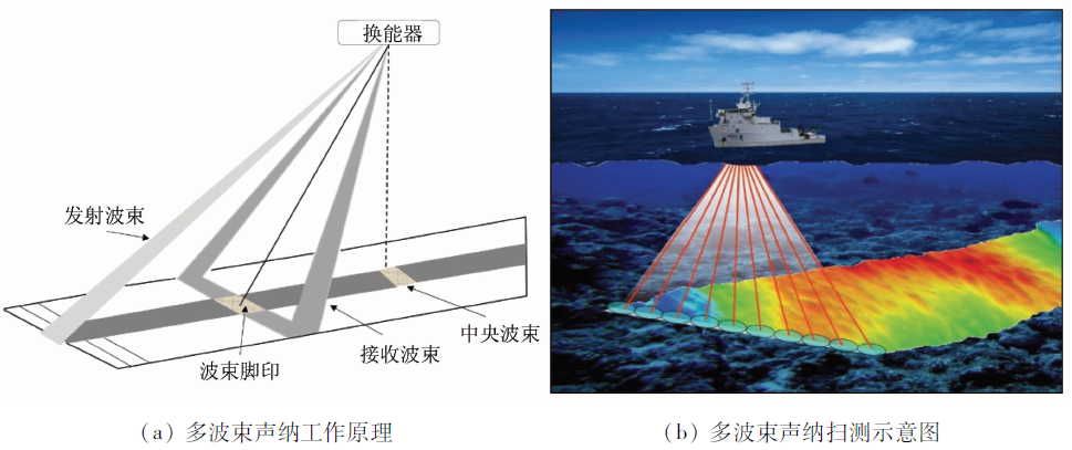
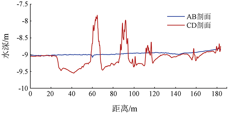
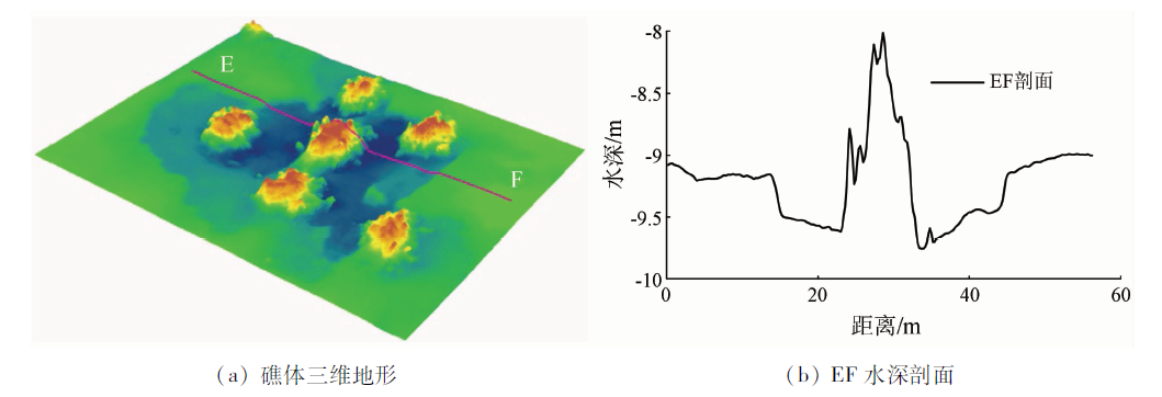
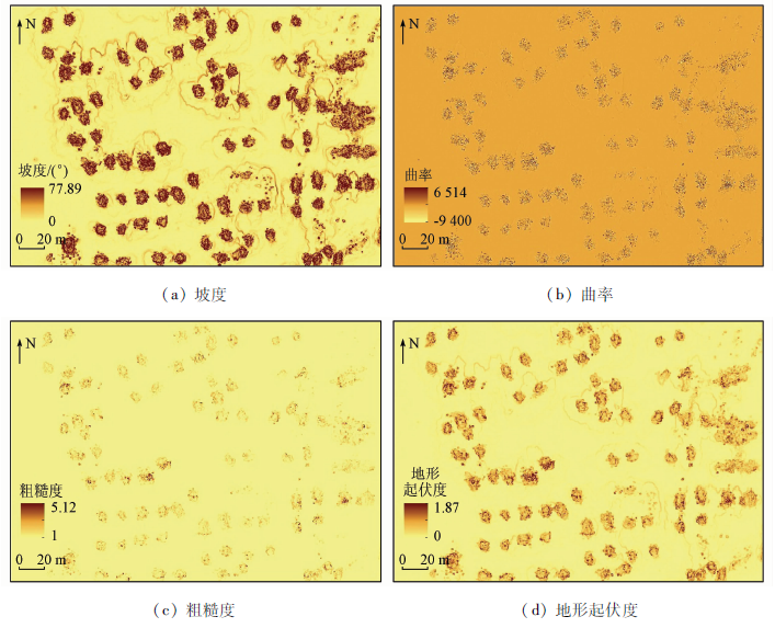
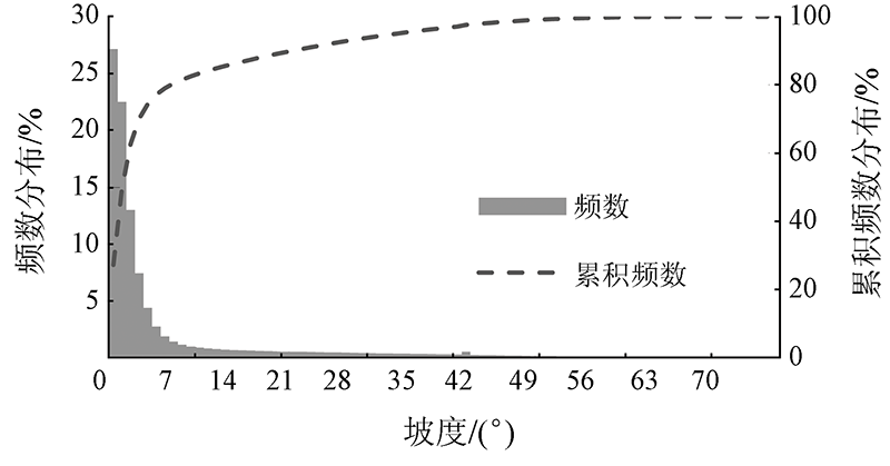
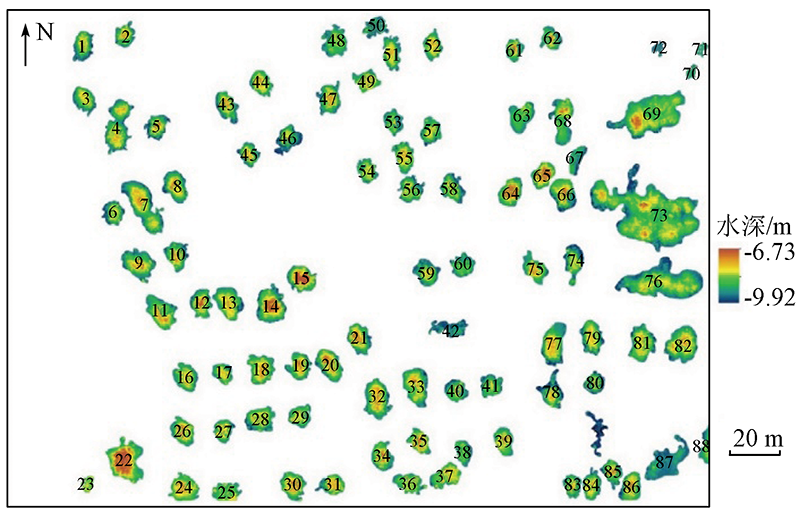
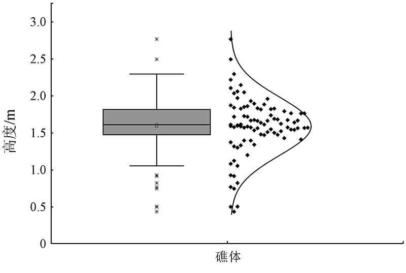
Mastering the subaqueous physical state of artificial reefs (ARs) is critical for assessing the benefits of ARs. Tradition survey methods suffer shortcomings such as low efficiency and incomplete information and cannot meet the requirements for the precise monitoring of ARs. This study established a high-precision DEM (digital elevation model) of ARs using a multibeam sonar system. Meanwhile, this study conducted a quantitative analysis of the distribution, height, volume, and complex topographic features of ARs using the GIS (geographic information system) spatial analysis method. The high-precision DEM was tested in an offshore AR area in Shandong Province, obtaining the following results. The AR area has a water depth of -9.92~-6.73 m. The ARs in the area are stacked in piles with different distances, with a total reef volume of 5 458.49 m3. Meanwhile, 50% of the ARs have a height of 1.48~1.82 m. The terrain characteristic variables such as slope, curvature, rugosity, and topographic relief intensively show high values in the reef distribution area. Affected by their own gravity and local hydrodynamic force, the ARs have a subsidence depth of about 0.5 m, leading to the formation of the special erosion and silting terrain around the ARs. This study can provide technical and data support for the monitoring and assessing the physical stability of ARs and thus is practically significant.
李东, 唐诚, 邹涛, 侯西勇. 近海人工鱼礁水下物理状态探测与评估[J]. 自然资源遥感, 2022, 34(1): 27-33.
LI Dong, TANG Cheng, ZOU Tao, HOU Xiyong. Detection and assessment of the physical state of offshore artificial reefs. Remote Sensing for Natural Resources, 2022, 34(1): 27-33.
Seaman W. Artificial habitats and the restoration of degraded marine ecosystems and fisheries[J]. Hydrobiologia, 2007, 580(1):143-155.
doi: 10.1007/s10750-006-0457-9
Yang H S, Xu S, Lin C G, et al. Research progress and prospects of restoration and resource conservation in typical sea areas[J]. Oceanologia et Limnologia Sinica, 2020, 51(4):809-820.
Lin J, Zhang S Y. Research advances on physical stability and ecological effects of artificial reef[J]. Marine Fisheries, 2006, 28(3):257-262.
[4]
Tynyakov J, Rousseau M, Chen M, et al. Artificial reefs as a means of spreading diving pressure in a coral reef environment[J]. Ocean and Coastal Management, 2017, 149:159-164.
doi: 10.1016/j.ocecoaman.2017.10.008
Zhang L B, Yang H S. Advances in principles and techniques of marine habitat restoration and biological resource conservation[J]. Chinese Bulletin of Life Science, 2012, 24(9):1062-1069.
Tang Y L, Long X Y, Wang X X, et al. Comparative analysis on flow field effect of general artificial reefs in China[J]. Transactions of the Chinese Society of Agricultural Engineering, 2017, 33(8):97-103.
[7]
Schygulla C, Peine F. Nienhagen reef:Abiotic boundary conditions at a large brackish water artificial reef in the Baltic Sea[J]. Journal of Coastal Research, 2013, 29(2):478-486.
Liu H Y, Yang C J, Zhang P D, et al. An Ecopath evaluation of system structure and function for the Laoshan Bay artificial reef zone ecosystem[J]. Acta Ecologica Sinica, 2019, 39(11):3926-3936.
[9]
Jiang Z, Liang Z, Zhu L, et al. Numerical simulation of effect of guide plate on flow field of artificial reef[J]. Ocean Engineering, 2016, 116:236-241.
doi: 10.1016/j.oceaneng.2016.03.005
Shen W, Zhang S Y, Li Y P, et al. The application of C3D bathymetry side scan sonar system in artificial reef construction[J]. Journal of Shanghai Ocean University, 2013, 22(3):404-409.
[11]
Hou Z, Chen Z, Wang J, et al. Acoustic impedance properties of seafloor sediments off the coast of Southeastern Hainan,South China Sea[J]. Journal of Asian Earth Sciences, 2018, 154:1-7.
doi: 10.1016/j.jseaes.2017.12.003
[12]
Li D, Tang C, Xia C, et al. Acoustic mapping and classification of benthic habitat using unsupervised learning in artificial reef water[J]. Estuarine,Coastal and Shelf Science, 2017, 185:11-21.
doi: 10.1016/j.ecss.2016.12.001
Liu Y H, Liu M, Tian T, et al. The application of side scan sonar system in volume estimation of stone artificial reef[J]. Journal of Fisheries of China, 2017, 41(7):1158-1167.
Shen T Y, Zhang S Y, Shen W, et al. Cluster analysis on distribution status of artificial reefs in field sea area[J]. Journal of Fisheries of China, 2015, 39(9):1350-1358.
Guo D, Dong J, Fu J, et al. Artificial reef and fisheries estimation in Dalu Island based on dual frequency sonar[J]. Transactions of Oceanology and Limnology, 2018(2):41-48.
[16]
Yoon H S, Kim D, Na W B. Estimation of effective usable and burial volumes of artificial reefs and the prediction of cost-effective management[J]. Ocean and Coastal Management, 2016, 120:135-147.
doi: 10.1016/j.ocecoaman.2015.12.007
Li D, Tang C, Zou T, et al. Terrain character analysis of artificial reefs area based on multibeam echo sounder[J]. Marine Sciences, 2017, 41(5):127-133.
[18]
Lurton X. Swath bathymetry using phase difference:Theoretical analysis of acoustical measurement precision[J]. IEEE Journal of Oceanic Engineering, 2000, 25(3):351-363.
doi: 10.1109/48.855385
Xu Z M, Lin Z Y, Li W J, et al. DEM accuracy evaluation model based on cut fill method[J]. Geomatics and Information Science of Wuhan University, 2017, 42(8):1167-1171.
Xu G Q, Du J, Tian Z W, et al. High precision measurement technology for the volume of submarine irregular accumulations in coastal waters and its application[J]. Coastal Engineering, 2017, 36(4):30-36.
[21]
Yun D H, Kim Y T. Experimental study on settlement and scour characteristics of artificial reef with different reinforcement type and soil type[J]. Geotextiles and Geomembranes, 2018, 46(4):448-454.
doi: 10.1016/j.geotexmem.2018.04.005
Zou T, Zhang L B, Zhang H, et al. Hydrodynamic characteristics in the artificial reefing construction area in Laizhou Bay:Based on a continuous long-term observation[J]. Oceanologia et Limnologia Sinica, 2018, 49(2):280-289.
[24]
Ha H K, Maa P Y, Holland C W. Acoustic density measurements of consolidating cohesive sediment beds by means of a non-intrusive “Micro-Chirp” acoustic system[J]. Geo-Marine Letters, 2010, 30(6):585-593.
doi: 10.1007/s00367-010-0206-y
 2022, Vol. 34
  ), 唐诚1,2,3, 邹涛2, 侯西勇1,2,3(