Please wait a minute...
 
自然资源遥感  2022, Vol. 34 Issue (2): 176-183    DOI: 10.6046/zrzyyg.2021206
  技术应用 本期目录 | 过刊浏览 | 高级检索 |
GXL二次开发在国产卫星数据处理中的应用研究
张伟1(), 张涛1(), 郑雄伟2, 齐建伟1, 王光辉1
1.自然资源部国土卫星遥感应用中心,北京 100048
2.中国地质调查局,北京 100037
Application of the software development kit of GXL in the processing of domestic satellite data
ZHANG Wei1(), ZHANG Tao1(), ZHENG Xiongwei2, QI Jianwei1, WANG Guanghui1
1. Land Satellite Remote Sensing Application Center, MNR, Beijing 100048, China
2. China Geological Survey, Beijing 100037, China
全文: PDF(3974 KB)   HTML  
输出: BibTeX | EndNote (RIS)      
摘要 

地理成像加速器(Geoimaging Accelerator,GXL)作为新一代分布式遥感数据处理平台,其快速高效灵活的处理模式在国产卫星数据处理中发挥着重要作用。该文基于GXL软件框架MVC(Model View Controller)模式展开分析,分别从模型端、视图端以及控制端探索二次开发模式,通过开发新型算法处理模块和分布式程序部署,进而增强卫星数据处理功能算法。以高分一号、高分二号、资源一号02C国产卫星数据处理为例进行实验验证,结果表明GXL二次开发功能不仅可以灵活扩展卫星数据处理流程,还可以有效提高国产卫星产品生产效率,更好地满足各行业对国产卫星产品的业务需求。

服务
把本文推荐给朋友
加入引用管理器
E-mail Alert
RSS
作者相关文章
张伟
张涛
郑雄伟
齐建伟
王光辉
关键词 GXL二次开发国产卫星算法模块处理流程优化效率    
Abstract

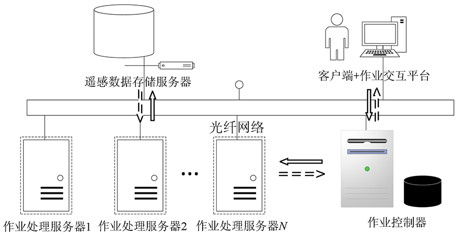
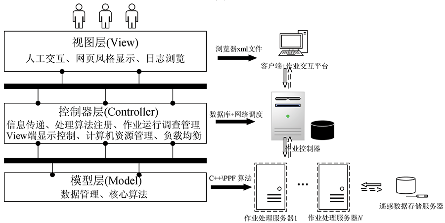
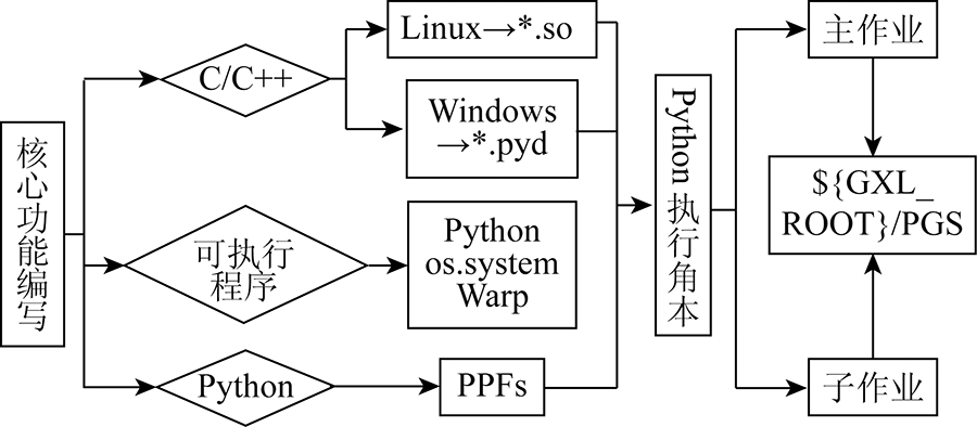
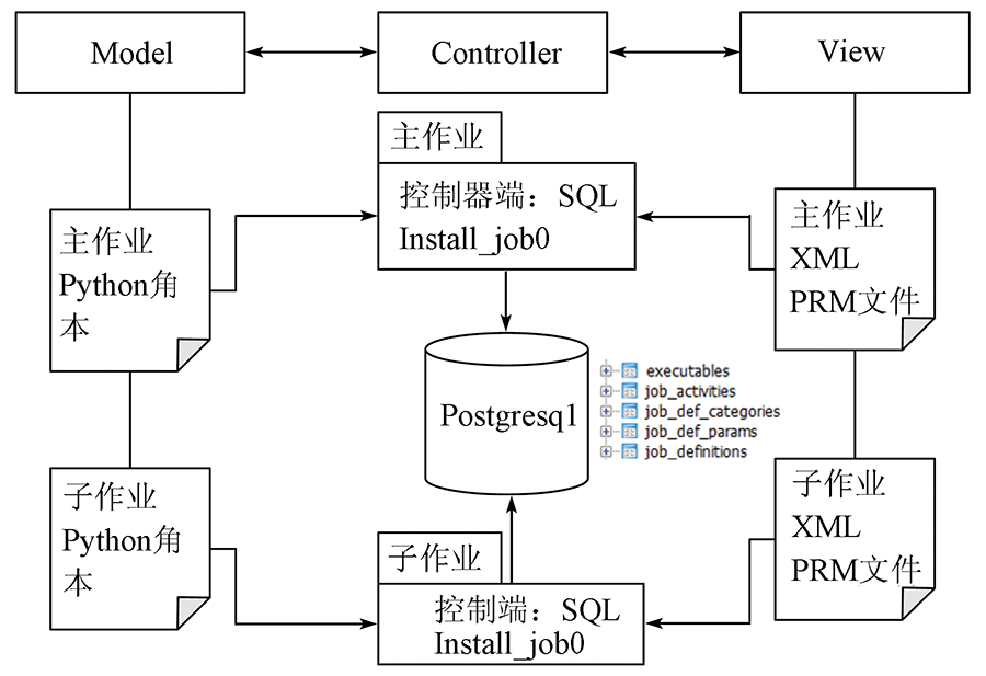
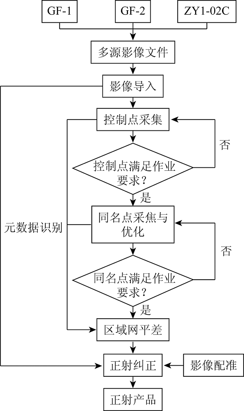
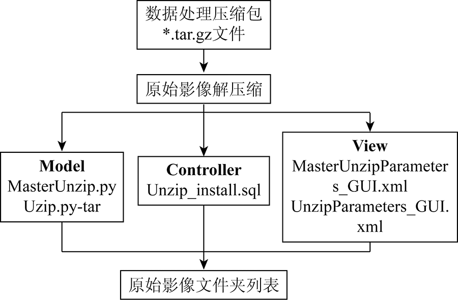
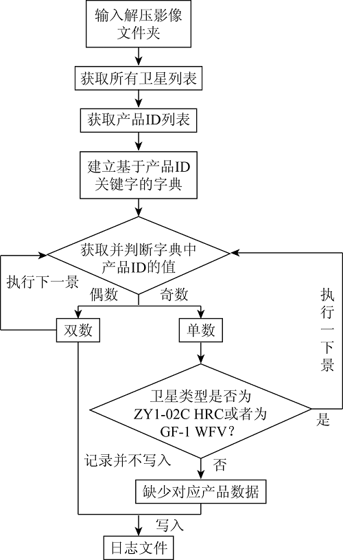
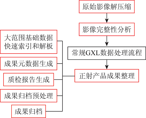
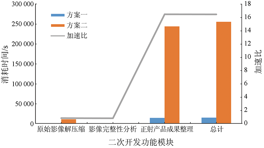
The GXL (GeoImaging Accelerator) is a new generation of distributed processing platform for remote sensing data. It is fast, efficient, and flexible and plays an important role in the processing of domestic satellite data. This study investigated the software development kit (SDK) of GXL from the aspects of view, controller, and model based on the MVC (Model View Controller) framework of GXL. Furthermore, it developed a new algorithm processing module and employed distributed program deployment to enhance the function and algorithms of satellite data processing. An experiment was carried out to process domestic satellite (GF-1, GF-2, and ZY1-02C) data. The experiment results show that the SDK of GXL allows for flexibly expanding the processes for satellite data processing and improving the productivity of domestic satellite products. Therefore, the SDK of GXL can better satisfy the demands of various industries.

Key wordsGXL SDK    domestic satellite    algorithm module    processing flow    optimization efficiency
收稿日期: 2021-06-30      出版日期: 2022-06-20
ZTFLH:  TP79  
基金资助:国家重点研发计划课题“基于多源数据融合的敏感目标识别技术”(2018YFC0825800)
通讯作者: 张涛
作者简介: 张 伟(1988-),男,工程师,主要从事国产卫星数据处理软件开发与信息提取算法研究。Email: dave6806@163.com
引用本文:   
张伟, 张涛, 郑雄伟, 齐建伟, 王光辉. GXL二次开发在国产卫星数据处理中的应用研究[J]. 自然资源遥感, 2022, 34(2): 176-183.
ZHANG Wei, ZHANG Tao, ZHENG Xiongwei, QI Jianwei, WANG Guanghui. Application of the software development kit of GXL in the processing of domestic satellite data. Remote Sensing for Natural Resources, 2022, 34(2): 176-183.
链接本文:  
https://www.gtzyyg.com/CN/10.6046/zrzyyg.2021206      或      https://www.gtzyyg.com/CN/Y2022/V34/I2/176
Fig.1  GXL功能组件架构图
Fig.2  GXL软件的MCV框架
Fig.3  模型端开发
元素 类型 描述信息
<Name> String 输出域名
<Description> String 用以对变量进行说明描述
<TextConstraint> Bolean 此选项是否为必须
<FileConstraint> Constraint 特批输入框为文件属性,可限制长度
<FolderConstraint> Constraint 特批输入框为文件夹属性,可限制其长度
<IntegerConstraint> Constraint 指定输入为整形数据
<DoubleContraint> Constraint 指定输入为双精度类型数据
<ComboConstraint> Constraint 指定为下拉框选择组件
Tab.1  GUI RPM XML结构元素表
Fig.4  正射纠正模块视图端显示
Fig.5  控制端二次开发部署图
Fig.6  GXL国产卫星数据处理流程
Fig.7  “原始影像解压缩”MCV开发图
卫星类型 传感器类型 完整影像数据数/个
GF-1 PMS
WFV
2
1
GF-2 PMS 1
ZY1-02C PMS
HRC
2
1
Tab.2  原始数据完整性描述
Fig.8  “影像完整性检查”Model 设计
新增模块 是否有
子作业
描述信息
大范围基础数据快速索引和解析 建立成果数据与参考资料之间的索引,快速实现几何控制点的查找
成果元数据生成 针对成果数据生成xml描述文件和四置范围矢量数据
质检报告生成 为影像成果生成快视图、拇指图和pdf质检报告
成果归档预处理 建立成果标识号
成果归档 依据业务成果重命名规则对成果数据重新命名整理
Tab.3  正射产品成果整理二次开发模块说明
Fig.9  二次开发扩展国产卫星数据处理流程
卫星类型 景数 方案一/s 方案二/s 加速比
平均
时间
GXL
开发
平均
时间
人工
单机
GF-1 322 11.0 251.5 10.6 3 413.2
GF-2 215 36.0 361.3 34.0 7 310.0
ZY1-02C 76 10.5 80.2 10.4 790.4
总计 613 693.0 11 513.6 16.614
Tab.4  原始影像解压缩时间统计表
事件类型 方案一/s 方案二/s 加速比
时间统计 9.0 7.6 0.84
可操作性 可嵌入GXL流程,操作简便 独立不能嵌入流程
实验结果 结果相同
Tab.5  影像完整性分析时间统计表
作业模块 方案一/s 方案二/s 加速比
M1 29.0 25.0 0.86
M2 4 641.0 15 922.0 3.43
M3 9 423.5 219 638.0 23.30
M4 15.0 14.0 0.93
M5 704.0 8 814.2 12.52
总计 14 813.0 244 413.2 16.49
Tab.6  正射产品成果整理时间统计表
作业模块 方案一/s 方案二/s 加速比
原始影像解压缩 693.0 11 513.6 0.86
影像完整性分析 9.0 7.6 0.84
正射产品成果整理 14 813.0 244 413.2 16.49
总计 15 515.0 255 934.4 16.48
Tab.7  二次开发与常规处理流程时间统计表
Fig.10  二次开发中各模块运行效率比对图
[1] 王伟, 毛继宗, 张溪. 面向地理国情的正射影像集群生产模式探讨[J]. 地理空间信息, 2016, 14(8):5-7.
Wang W, Mao J Z, Zhang X. Discussion on the production model of orthorectification in geographical conditions census by clusters[J]. Geospatial Information, 2016, 14(8):5-7.
[2] 米超川, 刘英. 基于GXL系统利用高分辨率卫星影像制作正射影像[J]. 测绘标准化, 2014, 30(2):43-44.
Mi C C, Liu Y. DOM production by using high-resolution satellite images based on GXL system[J]. Standardization of Surveying and Mapping, 2014, 30(2):43-44.
[3] 杨静, 周晓敏, 韩鹏飞. PCI GXL在国情普查项目中的应用[J]. 测绘与空间地理信息, 2014, 37(6):154-156.
Yang J, Zhou X M, Han P F. The application of the PCI GXL project in the state of the census[J]. Geomatics & Spatial Infomation Technology, 2014, 37(6):154-156.
[4] Bai J, Gao J, Dang Y, et al. Research on automated data processing method of PCI geographic imaging accelerator (GXL) system for big data of superview-1 remote sensing image[J]. ISPRS-International Archives of the Photogrammetry,Remote Sensing and Spatial Information Sciences, 2020, XLII-3/W10:691-697
doi: 10.5194/isprs-archives-XLII-3-W10-691-2020
[5] Xu Z B, Li A H, Yan Y, et al. TH01 satellite image data processing based on GXL[J]. Geomatics & Spatial Information Technology, 2017:86-88.
[6] Wu X T, Xu R K, Wang Y M. Study on production of massive remote sensing data based on GXL[J]. Modern Surveying and Mapping, 2015:23-25.
[7] Hruby F, Melamed S, Ressl R, et al. Mosaicking mexico-the big picture of big data[J]. XXIII ISPRS Congress,Commission II. 2016, 41(B2):407-412.
[8] 张世群, 罗天银, 张平. PCI Geomatica 2013(GXL)软件在地理国情监测卫星影像生产中的应用[J]. 测绘, 2014, 37(5):233-236.
Zhang S Q, Luo T Y, Zhang P. The application of PCI geomatica 2013(GXL) software in the production of satellite image for geographic conditions monitoring[J]. Surveying and Mapping, 2014, 37(5):233-236.
[9] 乔晓虹, 文广. GXL影像配准在1∶50000 DEM地区地理国情普查标准时点核准正射影像生产中的应用[C]// 云南省测绘地理信息学会2015年学术年会,昆明, 2015:303-307.
Qiao X H, Wen G. Application of GXL image registration of standard time point approval orthorectification in 1∶50000 DEM region of geographical conditions census project[C]// Compilation of Papers about Surveying and Mapping Geographic Information.Kunming China, 2015:303-307.
[10] 贾杰, 黄明莹, 万昀昕, 等. 基于PCI GXL的地理国情监测整景影像纠正技术研究[J]. 测绘与空间地理信息, 2018, 41(12):129-132.
Jia J, Huang M Y, Wang Y X, et al. Research on image rectification technology of geographical condition monitoring based on PCI GXL[J]. Geomatics & Spatial Information Technology, 2018, 41(12):129-132.
[11] 孔令尧. 地理国情监测数字正射影像快速生产方法研究[J]. 经纬天地, 2020(4):82-86.
Kong L Y. Research on rapid production method of digital orthophoto image for geographic national conditions monitoring[J]. Survey World, 2020(4):82-86.
[12] 李芹. 基于GEOWAY CIPS,PCI GXL在数字正射影像生产中的应用[J]. 测绘与空间地理信息, 2015, 38(12):141-142.
Li Q. The Application of DOM based on GEOWAY CIPS and PCI GXL[J]. Geomatics & Spatial Infomation Technology, 2015, 38(12):141-142.
[13] 王伟, 杨海明, 向娟. 基于GXL的影像生产管理系统设计与应用[J]. 地理空间信息, 2017, 15(9):77-78.
Wang W, Yang H M, Xiang J. Design and application of image production management system based on GXL[J]. Geospatial Information. 2017, 15(9):77-78.
[14] Chu J, Zhao J, Gao N, et al. Application of domestic satellite image fast ortho-rectification method in dynamic remote sensing monitoring of sea area[C]// 9th International Conference on Intelligent Control and Information Processing (ICICIP).Wanzhou, 2018:134-138.
[15] 陶兰花, 马静, 李娜娜, 等. 基于PCI GXL与INPHO软件在GF-7影像生产中的应用[J]. 地理空间信息, 2021, 19(8):90-92,96.
Tao L H, Ma J, L N N, et al. Application of GF-7 image production based on PCI GXL and INPHO software[J]. Geospatial Information, 2021, 19(8):90-92,96.
[1] 郑雄伟, 彭孛, 尚坤. 基于国产卫星的遥感地质解译能力评估[J]. 自然资源遥感, 2021, 33(3): 1-10.
[2] 蒋校, 路云阁, 孙昂, 李勇志, 连铮. 国产高分一号卫星数据在境外地质矿产调查中的应用——以伊朗法尔亚地区为例[J]. 国土资源遥感, 2021, 33(1): 199-204.
[3] 董双发, 姜雪, 李名松, 王瑞军, 孙永彬. 基于国产卫星数据的全要素遥感地质解译体系研建——以干旱半干旱高寒山区为例[J]. 国土资源遥感, 2017, 29(s1): 21-26.
[4] 丁宇雪, 初禹, 薛广垠. 利用国产卫星数据开展湿地调查——以黑龙江省为例[J]. 国土资源遥感, 2017, 29(s1): 151-154.
[5] 郑雄伟, 魏英娟, 李春英, 雷兵, 甘宇航. 基于多源海量国产卫星影像智能优选实现[J]. 国土资源遥感, 2017, 29(s1): 13-20.
[6] 丁宇雪. 基于国产卫星数据自然资源调查研究——以黑龙江省中西部地区为例[J]. 国土资源遥感, 2017, 29(s1): 121-126.
[7] 张幼莹, 余江宽, 张丹丹, 林华暖. 国产卫星影像本底数据更新的实用方案——以地质灾害易发区遥感影像为例[J]. 国土资源遥感, 2017, 29(1): 149-157.
[8] 钮立明, 蒙继华, 吴炳方, 陈雪洋, 杜鑫, 张飞飞. HJ-1A星HSI数据2级产品处理流程研究[J]. 国土资源遥感, 2011, 23(1): 77-82.
[9] 吴昀昭, 唐泽圣. 嫦娥一号IIM数据应用处理流程分析[J]. 国土资源遥感, 2009, 21(4): 25-30.
[10] 祝小勇, 张过, 秦绪文. 国产光学卫星影像RPC制作[J]. 国土资源遥感, 2009, 21(2): 32-34.
Viewed
Full text


Abstract

Cited

  Shared   
  Discussed   
京ICP备05055290号-2
版权所有 © 2015 《自然资源遥感》编辑部
地址:北京学院路31号中国国土资源航空物探遥感中心 邮编:100083
电话:010-62060291/62060292 E-mail:zrzyyg@163.com
本系统由北京玛格泰克科技发展有限公司设计开发