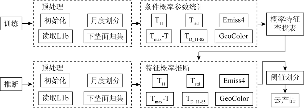
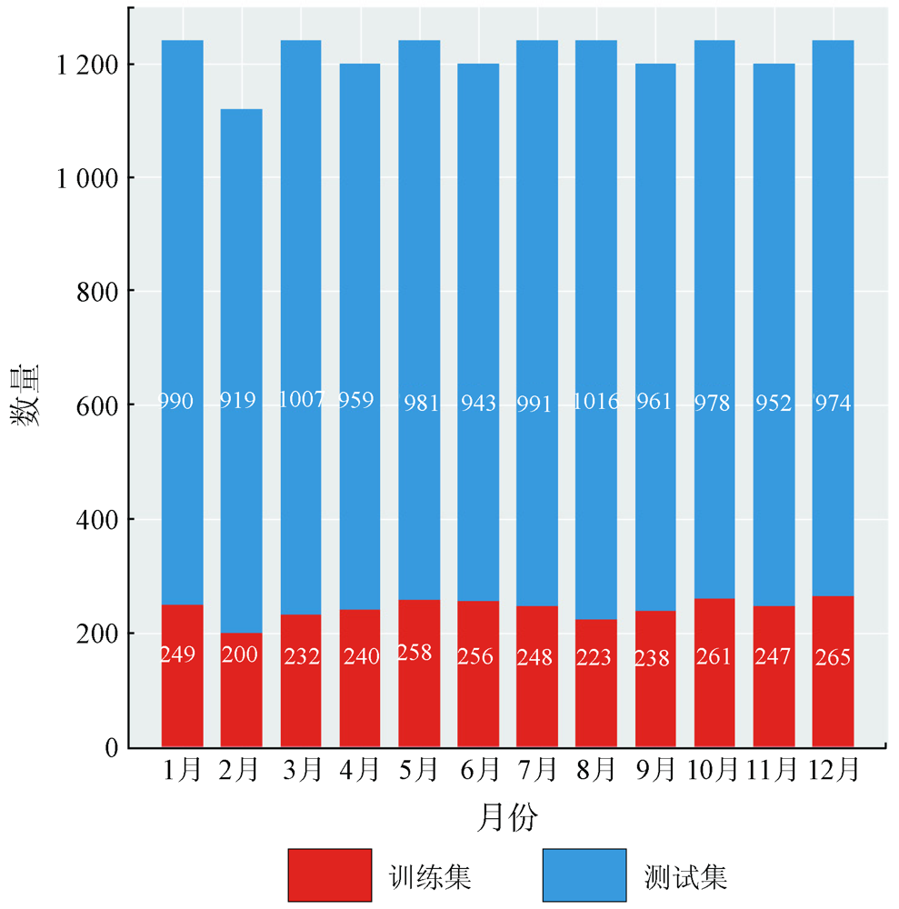
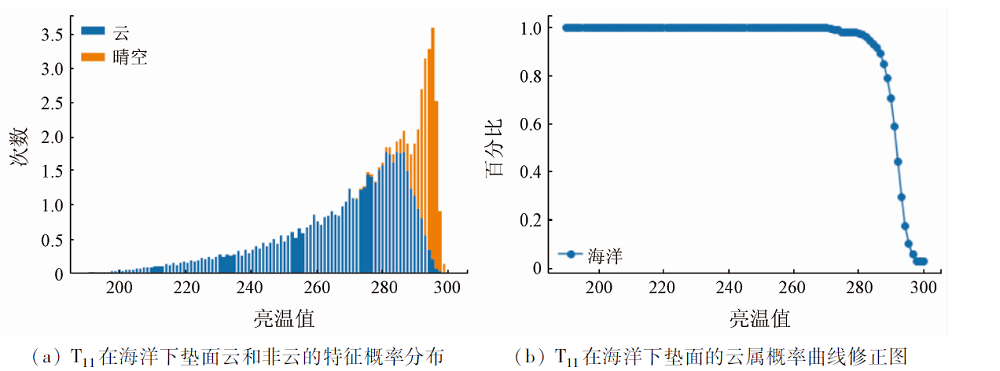
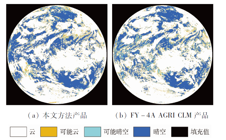
This study developed an automatic cloud detection method based on the naive Bayes algorithm for the cloud detection of the advanced geosynchronous radiation imager (AGRI) aboard the FY-4A satellite. In this method, the naive Bayes algorithm serves as the core structure, and appropriate infrared channels are selected as the parameters of the characteristic classifier according to the basic cloud detection principle of optical payload to ensure the consistency of cloud detection between day and night. After the classified training and construction for different surface types and different months, a cloud detection model based on the naive Bayes algorithm was finally established. Moreover, the classifier for FY-4A/AGRI data used in the method was established considering seven typical cloud detection characteristics and one characteristic based on the infrared composite images. As indicated by the learning tests and verification using the business cloud detection product of the National Satellite Meteorological Center (NSMC) in 2019, the classifier yielded a probability of detection (POD) greater than 98% for land, desert, shallow water, and deep sea, greater than 80% for snow cover, and greater than 80% for North and South poles. The comparison between the cloud detection results of this study and those obtained using the NSMC business system showed that the cloud detection results of this study had an average monthly POD of the whole year greater than 98%, a false alarm ratio (FAR) less than 5%, and all Kuiper’s skill scores (KSSs) greater than 90%.
鄢俊洁, 郭雪星, 瞿建华, 韩旻. 基于朴素贝叶斯方法的FY-4A/AGRI云检测模型[J]. 自然资源遥感, 2022, 34(3): 33-42.
YAN Junjie, GUO Xuexing, QU Jianhua, HAN Min. An FY-4A/AGRI cloud detection model based on the naive Bayes algorithm. Remote Sensing for Natural Resources, 2022, 34(3): 33-42.
Yang Y P, Dong X G, Dai C M, et al. Cirrus clouds properties in the arctic in summer based on MODIS data[J]. Infrared and Laser Engineering, 2016, 45(4):30-37.
Qin Y, Fu Z L, Zhou F, et al. A method of automatic cloud detection using TM image[J]. Geomatics and Information Science of Wuhan University, 2014, 39(2):234-238.
Seze G, Rossow W B. Time-cumulated visible and infrared radiance histograms used as descriptors of surface and cloud variations[J]. International Journal of Remote Sensing, 1991, 12(5):877-920.
doi: 10.1080/01431169108929702
[7]
Rossow W B, Garder L C. Cloud detection using satellite measurements of infrared and visible radiances for ISCCP[J]. Journal of Climate, 1993, 6(12):2341-2369.
doi: 10.1175/1520-0442(1993)006<2341:CDUSMO>2.0.CO;2
Liu J. Improvement of dynamic threshold value extraction technic in FY-2 cloud detection[J]. Journal of Infrared and Millimeter Waves, 2010, 29(4):288-292.
[9]
Saunders R W, Kriebel K T. An improved method for detecting clear sky and cloudy radiances from AVHRR data[J]. International Journal of Remote Sensing, 1988, 9(1):123-150.
doi: 10.1080/01431168808954841
[10]
Kriebel K T, Saunders R W, Gesell G. Optical properties of clouds derived from fully cloudy AVHRR pixels[J]. Beiträge zur Physik der freien Atmosphäre, 1989, 62:165-171.
[11]
Gesell G. An algorithm for snow and ice detection using AVHRR data an extension to the APOLLO software package[J]. International Journal of Remote Sensing, 1989, 10:4-5,897-905.
[12]
Stowe L L, McClain E P, Carey R, et al. Global distribution of cloud cover derived from NOAA/AVHRR operational satellite data[J]. Advances in Space Research, 1991, 11(3):51-54.
[13]
Stowe L L, Vemury S K, Rao A V. AVHRR clear sky radiation data sets at NOAA/NESDIS[J]. Advance in Space Research, 1994, 14(1):113-116.
[14]
Menzel W P, Wylie D P, Strabala K I. Seasonal and diurnal changes in cirrus clouds as seen in four years of observations with the VAS[J]. Journal of Applied Meteorology, 1992, 31(4):370-385.
doi: 10.1175/1520-0450(1992)031<0370:SADCIC>2.0.CO;2
[15]
Wylie D P, Menzel W P, Woolf H M, et al. Four years of global cirrus cloud statistics using HIRS[J]. Journal of Climate, 1994, 7(12):1972-1986.
doi: 10.1175/1520-0442(1994)007<1972:FYOGCC>2.0.CO;2
[16]
Shan N, Zheng T Y, Wang Z S. High-speed and high-accuracy algorithm for cloud detection and its application[J]. Journal of Remote Sensing, 2009, 13(6):1138-1146.
[17]
Goodman A H, Henderson-Sellers A. Cloud detection and analysis:A review of recent progress[J]. Atmospheric Research, 1988, 21(3-4):203-228.
doi: 10.1016/0169-8095(88)90027-0
Guan Z R, Tan Y H, Tian J W. A fast cloud detection method in remote sensing satellite images[J]. Computer and Digital Engineering, 2019, 47(11):2808-2811.
Qu J H, Yan J J, Xue J, et al. Research on the cloud detection model of FY3D /MERSI and EOS /MODIS based on deep learning[J]. Journal of Meteorology and Environment, 2019, 35(3):87-93.
[22]
董瑶海. 风云四号气象卫星及其应用展望[J]. 上海航天, 2016, 33(2):1-8.
Dong Y H. Fy-4 meteorological satellite and its application prospect[J]. Aerospace Shanghai, 2016, 33(2):1-8.
Lu F, Zhang X H, Chen B Y, et al. FY-4 geostationary meteorological satellite imaging characteristics and its application prospects[J]. Journal of Marine Meteorology, 2017, 37(2):1-12.
[24]
杨军. 气象卫星及其应用[M]. 北京: 气象出版社. 2012.
Yang J. Meteorological satellites and their applications[M]. Beijing: China Meteorological Press, 2012.
[25]
Ackerman S A, Smith W L, Revercomb H E, et al. The 27-28 October 1986 FIRE IFO cirrus case study:Spectral properties of cirrus clouds in the 8-12μm[J]. Monthly Weather Review, 1990, 118(11),2377-2388.
doi: 10.1175/1520-0493(1990)118<2377:TOFICC>2.0.CO;2
[26]
Miller S D, Lindsey D T, Seaman C J, et al. GeoColor:A blending technique for satellite imagery[J]. Journal of Atmospheric and Oceanic Technology, 2020, 37(3):429-448.
doi: 10.1175/JTECH-D-19-0134.1
 2022, Vol. 34
  ), 郭雪星(