|
|
|
| Integration and application of an aeromagnetic survey system based on unmanned helicopter platform |
| Yong-Zai XI1,2,3, Ning LU1,2,3, Lan ZHANG4, Jun-Feng LI1,2,3, Fu-Ming ZHANG5, Shan WU1,2,3, Gui-Xiang LIAO1,2,3, Fang BEN1,2,3, Wei HUANG1,2,3 |
1. Laboratory of Geophysical Electromagnetic Probing Technologies,Langfang 065000,China
2. Ministry of Natural Resources, Institute of Geophysical and Geochemical Exploration,CAGS,Langfang 065000,China
3. Laboratory of Geophysical EM Probing Technologies, MLR, Langfang 065000,China
4. North China Institute of Aerospace Engineering, Langfang 065000,China
5. Shanxi Provincial Coal Geological,Geophysical Prospecting,Surveying and Mapping Institute,Jinzhong 030600,China |
|
|
|
|
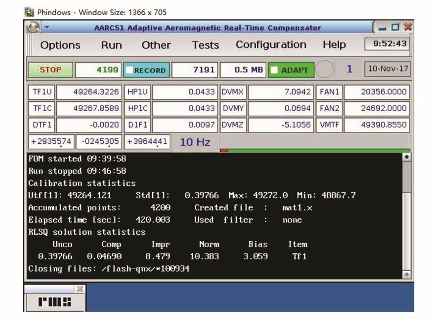
Abstract This paper introduces the research, development and integration of an unmanned helicopter aeromagnetic survey system. The system uses an unmanned helicopter as flying platform to carry out the high-precision aeromagnetic equipment. As all know, the unmanned helicopter doesn't need a runway to take off and land, and has the ability to self-navigate according to designed lines and to work at night. Thus, it can get a higher efficiency at a lower costing. An aeromagnetic compensation flight whose accuracy was 0.046 9 nT and several survey flights have been accomplished. Compared with the previous aeromagnetic survey in the same area, the characteristics of the geomagnetic field are basically alike, which validates the effectiveness of the unmanned helicopter aeromagnetic system. The unmanned helicopter aeromagnetic anomaly map is more detailed because of the different parameters such as scale and instrumental accuracy and sampling rate between the two systems. This unmanned helicopter aeromagnetic survey system provides an effective and flexible means for large scale, high-precision and small area aeromagnetic survey.
|
|
Received: 12 June 2018
Published: 20 February 2019
|
|
|
|
|
|
|
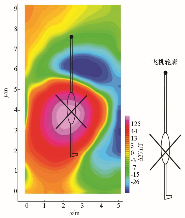
Magnetic back ground of the unmanned helicopter
|
|
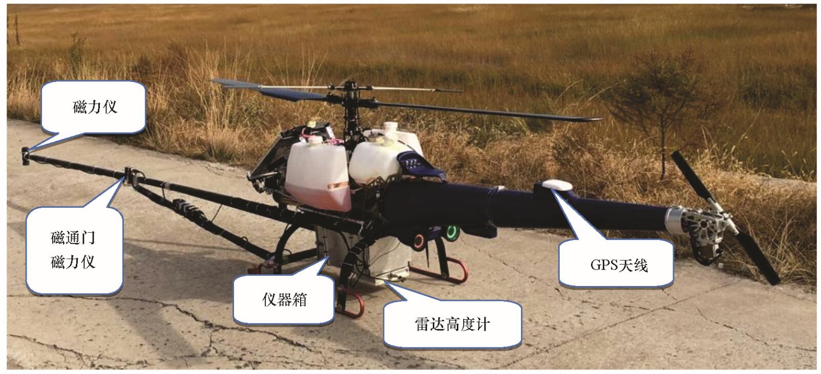
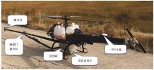
The unmanned helicopter aeromagnetic system
|
|
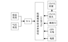
The diagram of the structure of the unmanned helicopter aeromagnetic survey system
|
|
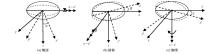
The diagram of hovering maneuver for the unmanned helicopter aeromagnetic compensation
a— roll; b—pitch; c— yaw
|
|
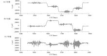
The profile of three components of fluxgate magnetometer
a— X component; b— Y component; c— Z component
|
|
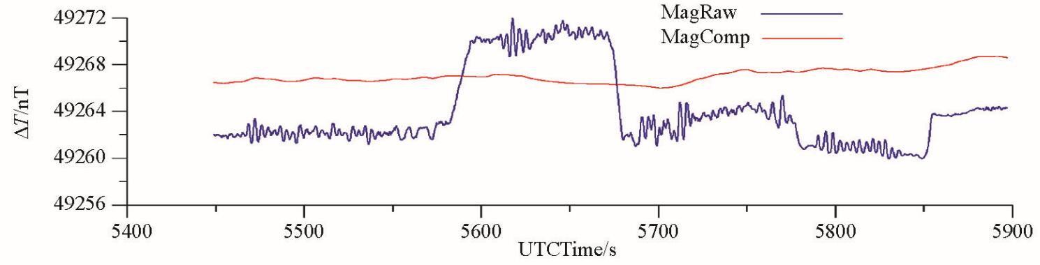
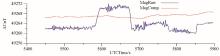
Comparison between raw data and compensated data
|
|
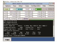
Result of the unmanned helicopter aeromagnetic compensation test flight
|
|
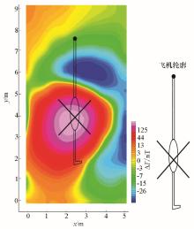
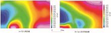
Comparison of aeromagnetic anomalies of a shoalarea in Jiangsu province
a— manned aerial vehicle aeromagnetic survey; b— unmanned helicopter aeromagnetic survey
|
| [1] |
张洪瑞, 范正国 . 2000年来西方国家航空物探技术的若干进展[J]. 物探与化探, 2007,31(1):451-457.

|
| [1] |
Zhang H R, Fan Z G . Recent advances in aero geophysical techniques used abroad[J]. Geophysical and Geochemical Exploration, 2007,31(1):451-457.
|
| [2] |
熊盛青 . “十五”以来我国航空物探进展与展望[J]. 物探与化探, 2007,31(6):479-484.
|
| [2] |
Xiong S Q . The advances of aero geophysical survey in China since the tenth five yare plan and its development trend[J]. Geophysical and Geochemical Exploration, 2007,31(6):479-484.
|
| [3] |
Barnard J. Use of unmanned air vehicles in oil,gas and mineral exploration activities [C]//.AUVSI Un-manned Systems North America 2010 Conference, 2010.
|
| [4] |
Lalibertee J . Carleton university fixed wing uavproject[D]. Canada:Carleton university, 2013.
|
| [5] |
Partner R . Georanger aeromagnetic UAV-from development to commercial survey[J]. Preveiw of Australian Society of Exploration Geophysicists, 2016,125:28-29.
|
| [6] |
Kurvinen K, Smolander P, Pollanen R , et al. Design of a radiation surveillance unit for an unmanned aerial vehicle[J]. Journal of Environmental Radioactivity, 2005,81:1-10.
|
| [7] |
Stoll J B .Unmanned aircraft system for rapid near surface geophysical measurements[J]. International archives of the photogrammetry International archives of the photogrammetry, Remote Sensing and Spatial Information Sciences, 2013, XL-1/W 2: 391-394.
|
| [8] |
Hitoshi M, Satoshi T, Yumiko O, et al. A development of airborne survey of gravity and magnetics on an unmanned helicopter and its data processing [C]//Japan Geoscience Union meeting, 2013.
|
| [9] |
李文杰, 李军峰, 刘世凯 , 等. 自主技术无人机航空物探(磁/放)综合站研发进展[J]. 地球学报, 2014,35(4):399-403.
|
| [9] |
Li W J, Li J F, Liu S K , et al. The progress in the decelopment of the integrated UAV magnetic &radiation survey system[J]. ActaGeoscienticaSinica, 2014,35(4):399-403.
|
| [10] |
中国地质科学院. 中国地质科学院2013年度十大科技进展揭晓[J]. 地球学报, 2014,35(1):1-5.
|
| [10] |
Chinese Academy of Geological Sciences. Top ten scientific and technological progress of Chinese academy of geological sciences in the year 2013 nuveiled[J]. ActaGeoscienticaSinica, 2014,35(1):1-5.
|
| [11] |
崔志强, 胥值礼, 李军峰 , 等. 无人机航空物探技术研发应用现状与展望[J]. 物探化探计算技术, 2016,38(6):740-745.
|
| [11] |
Cui Z Q, Xu Z L, Li J F , et al. The R & D application of UAV airborne geophysical survey and its developmenttrend[J]. Computing Techniques for Geophysical and Geochemical Exploration, 2016,38(6):740-745.
|
| [12] |
Z/T 0142-2010 航空磁测技术规范[S]. 北京: 中国标准出版社, 2010.
|
| [12] |
Z/T 0142-2010 Criterion of aeromagnetic survey[S]. Beijing: Standards Press of China, 2010.
|
| [13] |
刘晓杰 . 航磁补偿技术研究[D]. 长春:吉林大学, 2009.
|
| [13] |
Liu X J . Study on aeromagnetic compensation technique[D]. Changchun:Jilin University, 2009.
|
| [14] |
吴文福 . 16项自动磁补偿系统[J]. 声学与电子工程,1993(4):14-30.
|
| [14] |
Wu W F . 16 automatic magnetic compensation systems[J]. Acoustics and Electronics Engineering, 1993(4):14-30.
|
| [15] |
何敬礼 . 飞机磁补偿、磁补偿器的历史、现状及发展趋势[J].地学仪器,1991(3):1-7.
|
| [15] |
He J L . History, current situation and development trend of magnetic compensation and magnetic compensator for aircraft[J]. Equipment for Geotechnical Engineering, 1991(3):1-7.
|
| [16] |
何敬礼 . 飞机磁场的自动补偿方法[J]. 物探与化探, 1985,9(6):464-469.
|
| [16] |
He J L . Automatic compensation technique for the aeromagnetic field[J]. Geophysical and Geochemical Exploration, 1985,9(6):464-469.
|
| [17] |
李标芳, 王振东 . 飞机的磁干扰及电子补偿方法[J]. 物探与化探, 1979,3(1):35-43.
|
| [17] |
Li B F, Wang Z D . Magnetic interference and electronic compensation method for aircraft[J]. Geophysical and Geochemical Exploration, 1979,3(1):35-43.
|
| [18] |
Noriega G . Performance measures in aeromagnetic compensation[J]. The Leading Edge, 2011,30(10):1122-1127.
|
| [19] |
骆遥, 段树岭, 王金龙 , 等. AGS-863航磁全轴梯度勘查系统关键性指标测试[J]. 物探与化探, 2011,35(5):620-625.
|
| [19] |
Luo Y, Duan S L, Wang J L , et al. Key indicators testing for AGS-863 three axis airborne magnetic grandiometer[J]. Geophysical and Geochemical Exploration, 2011,35(5):620-625.
|
| [20] |
王林飞, 薛典军, 熊盛青 , 等. 航磁软补偿质量评价方法及软件实现[J]. 物探与化探, 2013,37(6):1027-1030.
|
| [20] |
Wang L F, Xue D J, Xiong S Q , et al. The method of quality assessment for digital magnetic compensation and software realization[J]. Geophysical and Geochemical Exploration, 2013,37(6):1027-1030.
|
| [1] |
CHEN Wei, ZHAO Guo-Feng, FEI Zhen-Zheng, LUO Ding, PENG Jiang-Ying, HUANG Yan, JIA Shuo. The application of unmanned helicopter aeromagnetic method to the survey of the iron deposit in Xiangshannan-Dadiantang area, Ma’anshan City, Anhui Province[J]. Geophysical and Geochemical Exploration, 2021, 45(4): 890-897. |
| [2] |
Yan HUANG, Ding LUO, Zi-Cheng FENG, Wei CHEN, Jian JIAO. Unmanned helicopter aeromagnetic measurement system and its application[J]. Geophysical and Geochemical Exploration, 2019, 43(2): 386-392. |
|
|
|
|