|
|
|
| Auto-renderring technology of aeromagnetic anomaly based on Oracle database |
| Jing LI, Lin-Fei WANG, Hao-Fei YAN |
| China Aero Geophysical Survey and Remote Sensing Center for Natural Resources, Beijing 100083, China |
|
|
|
|
Abstract Aeromagnetic anomaly data constitute one of the most important achievements in aeromagnetic work. It is the qualitative analysis of obtained aeromagnetic data via evaluation and interpretation. In order to meet the need of cartographic representation of final production map compiled by researchers in specific project, cartographers need to render the same data several times via different attributes. An Oracle database must be built as the unified storage and management platform so that the airborne geophysical data and information service can be provided efficiently. The authors investigated the mapping requirement of aeromagnetic anomaly and, in combination with management of Oracle database, constructed an auto-renderring model for aeromagnetic anomaly data. Then the authors implemented secondary development of auto-renderring workflow using C# language based on ArcEngine. Tests based on database data have validated that the results meet the standards. Now standardized API interfaces can be provided for other software development.
|
|
Received: 25 April 2019
Published: 03 March 2020
|
|
|
|
|
|

|
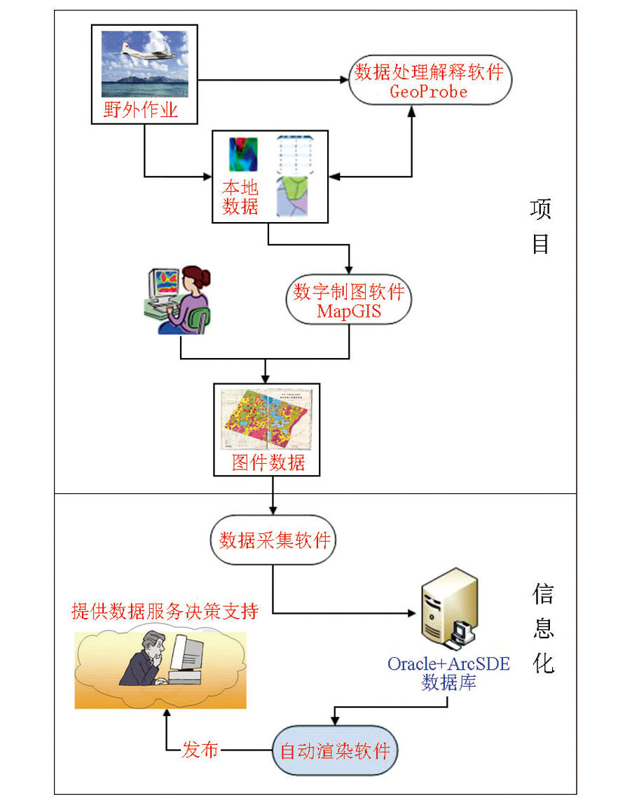
Aeromagnetic data production process
|

| 属性类 | 属性信息 | 符号形式 | | 异常类别 | 乙3 |  | | 异常性质 | 辉长岩引起的局部异常 |  | | 异常轴向 | 0 |  | | 异常编号 | 新C-2014-192 | 新C-2014-192 | | 异常位置 | (78.000,39.000) |  |
|
Renderring mathod of aeromagnetic anomaly data
|
|
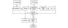
Auto renderring process for aeromagnetic anomaly data
|

|
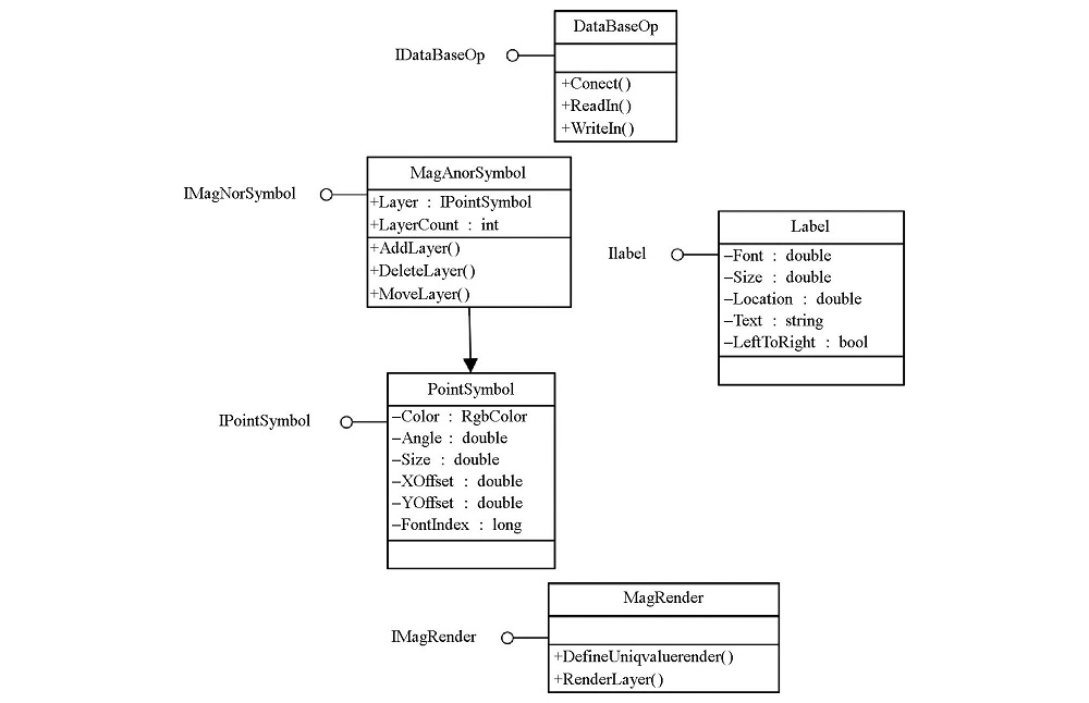
Construction of auto renderring class
|
|
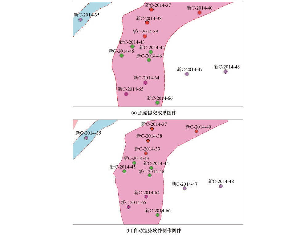
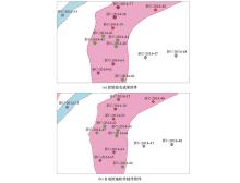
Comparison of accomplished maps
|
| [1] |
范正国, 黄旭钊, 熊盛青 , 等. 磁测资料应用技术要求[M]. 北京: 地质出版社, 2010.
|
| [1] |
Fan Z G, Huang X Z, Xiong S Q , et al. Technical requirements for magnetic data application[M]. Beijing: Geological Publishing House, 2010.
|
| [2] |
郭志宏, 徐昆 . 中国航磁异常管理信息系统开发与建设[J]. 地球物理学进展, 2002(4):703-710.
|
| [2] |
Guo Z H, Xu K . The Development and construction of aeromagnetic anomaly management information system of China[J]. Progress in Geophysics, 2002(4):203-710.
|
| [3] |
王林飞, 薛典军, 李芳 , 等. 航空物探测量数据共享技术研究与应用[J]. 物探与化探, 2015,39(S1):152-156.
|
| [3] |
Wang L F, Xue D J, Li F , et al. The study and application of sharing technology to aeromagnetic data[J]. Geophysical and Geochemical Exploration, 2015,39(S1):152-156.
|
| [4] |
王林飞, 薛典军, 李芳 , 等. 海洋航空物探数据库建设进展[J]. 海洋地质前沿, 2018,34(3):8-14.
|
| [4] |
Wang L F, Xue D J, Li F , et al. A marine aeromagnetic database for efficient data management[J]. Marine Geology Frontiers, 2018,34(3):8-14.
|
| [5] |
鲁志品, 肖德顺, 马晓光 . 制图新技术与传统地图编制的比较和影响[J]. 新疆地质, 2003(3):368.
|
| [5] |
Lu Z P, Xiao D S, Ma X G . Comparison and influence between new cartographic technology and traditional map compilation[J]. XinJiang Geology, 2003(3):368.
|
| [6] |
何辉, 薛典军, 王林飞 . 地球物理数据处理解释系统中坐标转换的设计及实现[J]. 物探与化探, 2014,38(5):1060-1063.
|
| [6] |
He H, Xue D J, Wang L F . The design and software realization of coordinate transormation for the geophysical data processing and interpretation system[J]. Geophysical and Geochemical Exploration, 2014,38(5):1060-1063.
|
| [7] |
方林彬 . 基于ArcGIS的电子地图快速制图方法研究[J]. 城市勘测, 2018(4):59-63.
|
| [7] |
Fang L B . Research on quick mapping method of electronic map based on ArcGIS[J]. Urban Geotechnical Investigation & Surveying, 2018(4):59-63.
|
| [8] |
马建芳 . 全矢量地质符号库的设计与实现[D]. 北京:中国地质大学(北京), 2013.
|
| [8] |
Ma J F . Design and implementation of full vector geological symbol library[D]. Beijing:China University of Geosciences (Beijing), 2013.
|
| [9] |
李琪, 王洪禄 . 基于ArcSDE的空间数据库的创建及应用[J]. 经济技术协作信息, 2019(11):20.
|
| [9] |
Li Q, Wang H L . Creation and application of spatial database based on ArcSDE[J]. Economic and Technological Cooperation Information, 2019(11):20.
|
| [10] |
杜萍, 刘涛, 李鼎凯 , 等. 应急场景快速制图及地图信息传输[J]. 测绘学报, 2019(6):747-755.
|
| [10] |
Du P, Liu T, Li D K , et al. Rapid mapping of emergency scenario and cartographic information transmission[J]. Acta Geodaetica et Cartographica Sinica, 2019(6):747-755.
|
| [11] |
李晓蕾, 高学正, 商云涛 , 等. 基于数据库驱动的地质图快速制图技术研究[J]. 中国矿业, 2018(27):88-92.
|
| [11] |
Li X L, Gao X Z, Shang Y T , et al. Study on the technology of rapid geological mapping based on the database drive[J]. China Mining Magazine, 2018(27):88-92.
|
| [12] |
徐文彬 . 利用GIS数据进行地图制图表达与更新[J]. 低碳世界, 2018(11):90-91.
|
| [12] |
Xu W B . Use GIS data to express and update maps[J]. Low Carbon World, 2018(11):90-91.
|
| [13] |
Zhou J X, Li Z, Chen Q , et al. The establishment of the SAR images database system based on Oracle and ArcSDE[J]. IOP Conference Series: Earth and Environmental Science, 2014(17):012267.
|
| [14] |
叶扬, 王明军, 程思聪 , 等. 一体化地图辅助设计系统的设计与实现[J]. 地理信息世界, 2019,26(3):93-98.
|
| [14] |
Ye Y, Wang M J, Cheng S C , et al. Design and Implementation of aided design system of integrated maps[J]. Geomatics World, 2019,26(3):93-98.
|
| [15] |
段婷 . 浅谈基于Arcgis自动化专题制图的关键技术[J]. 西部资源, 2017(2):145-146.
|
| [15] |
Duan T . Introduction to the key technology of automation thematic mapping based on Arcgis[J]. Western Resources, 2017(2):145-146.
|
| [16] |
冯磊, 周伟, 陈瑶 , 等. 航空物探工作程度图批量定制技术研究[J]. 物探与化探, 2019,43(1):153-160.
|
| [16] |
Feng L, Zhou W, Chen Y , et al. Research on technology of batch customizing aero geophysical survey regions maps[J]. Geophysical and Geochemical Exploration, 2019,43(1):153-160.
|
| [17] |
杨燕艳 . 基于ArcSDE的空间数据库技术的运用分析[J]. 信息通信, 2017(12):145-147.
|
| [17] |
Yang Y Y . Application analysis of spatial database technology based on ArcSDE[J]. Information and Communication, 2017(12):145-147.
|
| [18] |
花叶, 庞小平 . 基于地理信息框架数据库出图的关键技术[J]. 地理空间信息, 2019,17(6):42-46,8.
|
| [18] |
Hua Y, Pang X P . Mapping key technology of based on geographical information frame database[J]. Geospatial Information, 2019,17(6):42-46,8.
|
| [19] |
杨燕 . 浅谈新疆地质灾害快速制图系统[J]. 测绘与空间地理信息, 2018(10):196-198.
|
| [19] |
Yang Y . A brief discussion on the rapid mapping system of geological Hazards in Xinjiang[J]. Geomatics and Spatial Information Technology, 2018(10):196-198.
|
| [20] |
ArcGIS开发者帮助. https://pro.arcgis.com/zh-cn/pro-app/sdk/.

|
| [20] |
ArcGIS Developper Assistance. https://pro.arcgis.com/zh-cn/pro-app/sdk/.
|
| [1] |
CHEN Xiu-Juan, LIU Zhi-Di, LIU Yu-Xi, CHAI Hui-Qiang, WANG Yong. Research into the pore structure of tight reservoirs:A review[J]. Geophysical and Geochemical Exploration, 2022, 46(1): 22-31. |
| [2] |
XIAO Guan-Hua, ZHANG Wei, CHEN Heng-Chun, ZHUO Wu, WANG Yan-Jun, REN Li-Ying. Application of shallow seismic reflection surveys in the exploration of urban underground space in Jinan[J]. Geophysical and Geochemical Exploration, 2022, 46(1): 96-103. |
|
|
|
|