|
|
 |
|

|
|
|
Geometric calibration method of airborne hyperspectral instrument and its demonstration application in coastal airborne remote sensing survey |
| Yachao HAN1, Qi LI1,2, Yongjun ZHANG1, Zihong GAO1, Dachang YANG1, Jie CHEN1,3 |
1. China Aero Geophysical Survey and Romote Sensing Center for Natural Resources, Beijing 100083, China
2. Key Laboratory of Airborne Geophysics and Remote Sensing Geology, Ministry of Natural Resources, Beijing 100083, China
3. Institute of Remote Sensing and Digital Earth, Chinese Academy of Sciences, Beijing 100101, China |
|
|
|
|
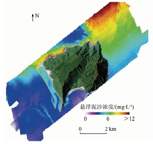
Abstract When coastal hyperspectral remote sensing measurement and survey are conducted, the water surface cannot be used for ground control point measurement, and hence the accurate external orientation element of the data cannot be obtained by the traditional aerial triangulation method. Therefore, how to ensure the geometric accuracy of the aerial remote sensing data is one of the key problems in measurement. In this study, the authors summarized and analyzed the geometrical correction principle and model characteristics of CASI 1500H push-broom airborne hyperspectral instrument and designed a set of geometric calibration schemes for this system. The calibration results show that the geometric accuracy of CASI 1500H hyperspectral image can still be significantly improved without control points. Using this geometric calibration method, the authors acquired CASI airborne hyperspectral data of Dajin Island and its surrounding waters. Based on these data, the authors retrieved the suspended sediment concentration in the surrounding waters of Dajin Island, and the overall accuracy was better than 70%, which can meet the need of coastal airborne remote sensing survey.
|
| Keywords
CASI 1500H hypersectral image
geometric calibration
coastal zone hyperspectral survey
suspended sediment concentration
|
|
|
|
Issue Date: 14 March 2020
|
|
|
| [1] |
马毅, 张杰, 张汉德 , 等. 中国海洋航空高光谱遥感应用研究进展[J]. 海洋科学进展, 2002,20(4):94-98.
|
| [1] |
Ma Y, Zhang J, Zhang H D , et al. Advances in application research on the marine airborne hyperspectral remote sensing in China[J]. Advances in Marine Science, 2002,20(4):94-98.
|
| [2] |
马毅, 张杰, 崔廷伟 . 基于SVM方法的赤潮生物优势种航空高光谱识别[J]. 光谱学与光谱分析, 2006,26(12):2302-2305.
|
| [2] |
Ma Y, Zhang J, Cui T W . Research on airborne hyperspectral identification of red tide organism dominant species based on SVM[J]. Spectroscopy and Spectral Analysis, 2006,26(12):2302-2305.
|
| [3] |
卜志国, 周凯, 黄娟 . 基于图像特征的航空高光谱数据油污染光谱曲线提取分析[J]. 中国海洋大学学报, 2005,35(4):687-690.
|
| [3] |
Bu Z G, Zhou K, Huang J . Spectral extraction and hyperspectral analysis of oil polluted water from airborne data using image characteristics[J]. Periodical of Ocean University of China, 2005,35(4):687-690.
|
| [4] |
刘茜, David G R . 基于高光谱数据和MODIS影像的鄱阳湖悬浮泥沙浓度估算[J]. 遥感技术与应用, 2008,23(1):7-11.
|
| [4] |
Liu Q, David G R . Estimation on suspended sedimentation concentration of Poyang Lake using MODIS and hyperspectral data[J]. Remote Sensing Technology and Application, 2008,23(1):7-11.
|
| [5] |
王永平, 李英成, 薛艳丽 , 等. ADS40推扫式数字航空传感器试验研究[J]. 测绘科学, 2007,32(1):119-121.
|
| [5] |
Wang Y P, Li Y C, Xue Y L , et al. Experinental investigation and application of ADS40 photogrammetry system[J]. Science of Surveying and Mapping, 2007,32(1):119-121.
|
| [6] |
Kocaman S, Casella V, Franzini M , et al. The triangulation accuracy of ADS40 imagery over the Pavia test site[C]// 2007 Conference of the Remote Sensing and Photogrammetry Society,Knala Lumpur: 2007.
|
| [7] |
Leica GeoSystems . CAP-A[R]. Leica, 2002: 76-78.
|
| [8] |
许妙忠, 涂辛茹 . 基于定标场的ADS40系统几何检校[J]. 武汉大学学报(信息科学版), 2011,36(7):771-775.
|
| [8] |
Xu M Z, Tu X R . Geometric calibration of ADS40 system based on test field[J]. Geomatics and Information Science of Wuhan University, 2011,36(7):771-775.
|
| [9] |
王涛, 张永生, 张艳 , 等. 基于自检校的机载线阵CCD传感器几何标定[J]. 测绘学报, 2012,41(3):393-400.
|
| [9] |
Wang T, Zhang Y S, Zhang Y , et al. Airborne linear CCD sensor geometric calibration based on self-calibration[J]. Acta Geodaetica et Cartographica Sinica, 2012,41(3):393-400.
|
| [10] |
朱樊, 欧素英, 张铄涵 , 等. 基于MODIS影像的珠江口表层悬沙浓度反演及时空变化分析[J]. 泥沙研究, 2015(2):67-73.
|
| [10] |
Zhu F, Ou S Y, Zhang S H , et al. MODIS images-based retrieval and analysis of spatial-temporal change of superficial suspended sediment concentration in the Pearl River estuary[J]. Journal of Sediment Research, 2015(2):67-73.
|
| [11] |
乔晓景, 何报寅, 张文 , 等. 基于MODIS的长江中游河段悬浮泥沙浓度反演[J]. 长江流域资源与环境, 2013,22(8):1090-1095.
|
| [11] |
Qiao X J, He B Y, Zhang W , et al. MODIS-based retrieval and change analysis of sediment concentration in middle yangtze suspended river[J]. Resources and Environment in the Yangtze Basin, 2013,22(8):1090-1095.
|
| [12] |
刁淑娟, 刘春玲, 张涛 , 等. 基于SVM的湖泊咸度等级遥感信息提取方法——以内蒙古巴丹吉林沙漠为例[J]. 国土资源遥感, 2016,28(4):114-118.doi: 10.6046/gtzyyg.2016.04.18.
|
| [12] |
Diao S J, Liu C L, Zhang T , et al. Extraction of remote sensing information for lake salinity level based on SVM:A case from Badain Jaran desert in Inner Mongolia[J]. Remote Sensing for Land and Resources, 2016,28(4):114-118.doi: 10.6046/gtzyyg.2016.04.18.
|
|
Viewed |
|
|
|
Full text
|
|
|
|
|
Abstract
|
|
|
|
|
Cited |
|
|
|
|
| |
Shared |
|
|
|
|
| |
Discussed |
|
|
|
|
 2020,
Vol. 32
2020,
Vol. 32