|
|
|
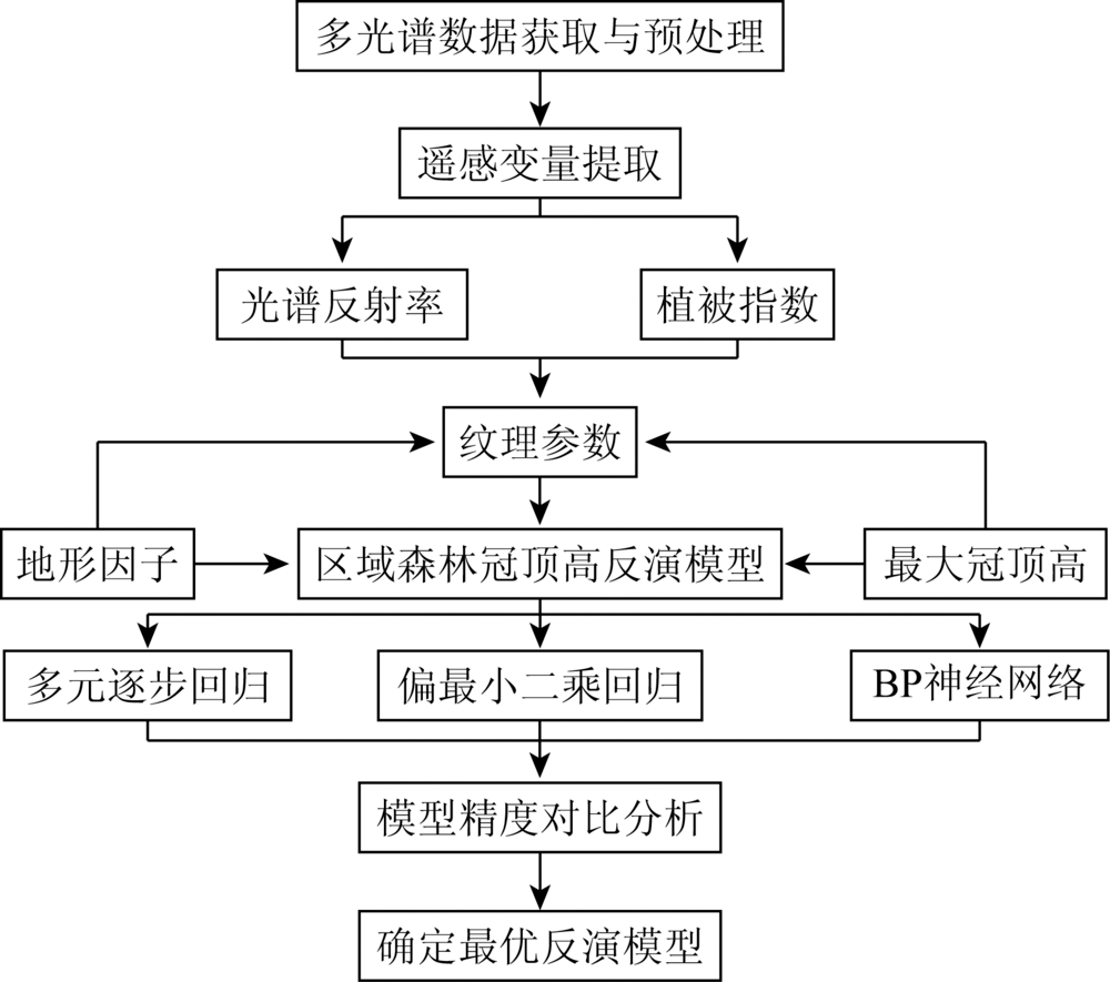
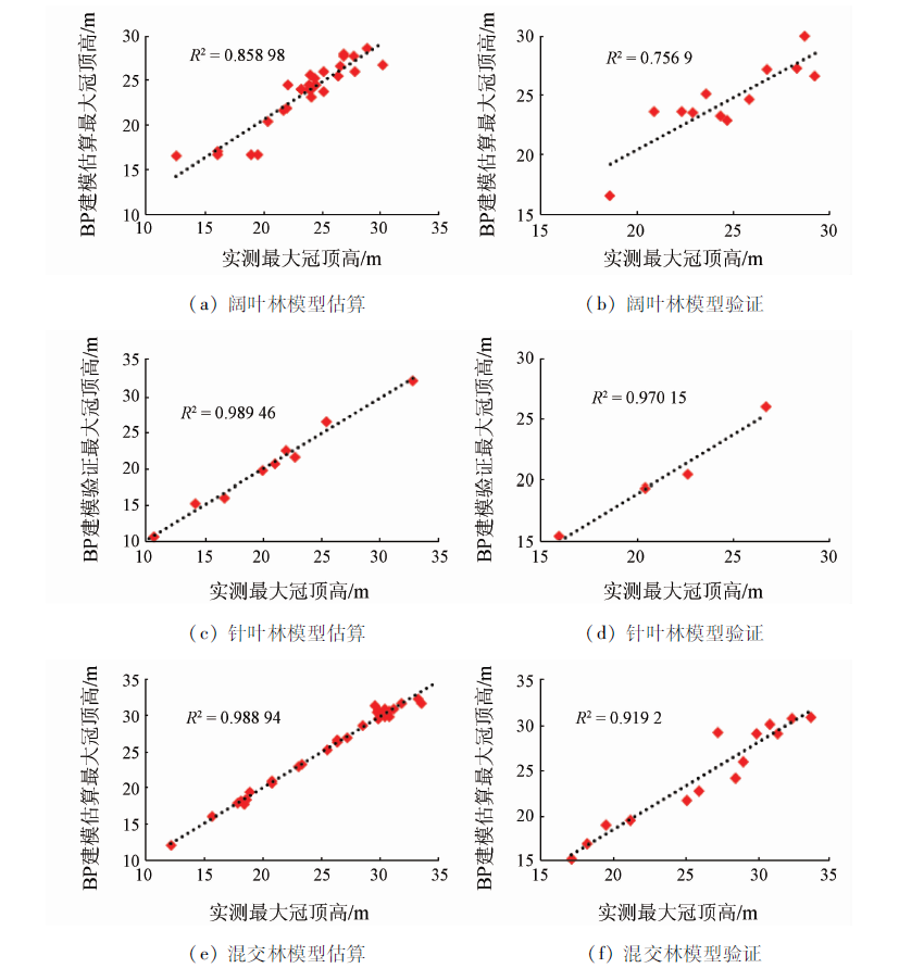
Abstract To tackle the problem of low inversion accuracy of regional forest crowns based on optical remote sensing data, in this study the authors used multiple stepwise regression (MSR), partial least squares regression (PLSR) and back-propagation (BP) network models to perform regional forest crown height inversion based on the texture, spectral and topographic characteristics of SPOT5 multispectral images. The inversion accuracy of the models was compared and analyzed to determine the optimal model for the study area. The results show that the correlation between the texture parameters of each forest type and the measured canopy height of the plot is better than other spectral parameters. The BP neural network model performs better than other models, and the determination coefficients R 2 of the validation results for the broad-leaved, coniferous, and mixed forest were 0.76, 0.97 and 0.92, respectively, and the root mean square error (RMSE) were 1.6 m, 1.35 m and 2.29 m, respectively. Studies have shown that texture parameters can reflect the structural characteristics of forest canopy well, and the BP neural network model combining image texture, spectrum and terrain feature parameters has good application potential in forest canopy height inversion.
|
| Keywords
forest canopy height
multi-spectral imagery
texture parameter
multiple stepwise regression model
partial least squares model
BP neural network model
|
|
|
|
Corresponding Authors:
WANG Xinchuang
E-mail: 972523964@qq.com;wangxc@hpu.edu.cn
|
|
Issue Date: 09 October 2020
|
|
|
| [1] |
张继平, 张林波, 刘春兰, 等. 井冈山中亚热带森林植被碳储量及固碳潜力估算[J]. 生态环境学报, 2016,25(1):9-14.
|
| [1] |
Zhang J P, Zhang L B, Liu C L, et al. Estimation of carbon storage and carbon sequestration potential of mid-subtropical forest vegetation in Jinggang Mountain[J]. Ecology and Eevironmental Sciences, 2016,25(1):9-14.
|
| [2] |
Pourrahmati M R, Baghdadi N N, Darvishsefat A A, et al. Capability of GLAS/ICESat data to estimate forest canopy height and volume in mountainous forests of Iran[J]. IEEE Journal of Selected Topics in Applied Earth Observations & Remote Sensing, 2017,8(11):5246-5261.
|
| [3] |
Wang Y, Li G, Ding J, et al. A combined GLAS and MODIS estimation of the global distribution of mean forest canopy height[J]. Remote Sensing of Environment, 2016,174(174):24-43.
doi: 10.1016/j.rse.2015.12.005
url: https://linkinghub.elsevier.com/retrieve/pii/S0034425715302261
|
| [4] |
Eisfelder C, Kuenzer C, Dech S. Iderivation of biomass information for semi-arid areas using remote-sensing data[J]. International Journal of Remote Sensing, 2012,33(9):2937-2984.
doi: 10.1080/01431161.2011.620034
url: http://dx.doi.org/10.1080/01431161.2011.620034
|
| [5] |
娄雪婷, 曾源, 吴炳方. 森林地上生物量遥感估测研究进展[J]. 国土资源遥感, 2011,23(1):1-8.doi: 10.6046/gtzyyg.2011.01.01.
doi: 10.6046/gtzyyg.2011.01.01
url: http://www.gtzyyg.com/CN/abstract/abstract584.shtml
|
| [5] |
Lou X T, Zeng Y, Wu B F. Advances in remote sensing estimation of aboveground biomass in forests[J]. Remote Sensing for Land and Resources, 2011,23(1):1-8.doi: 10.6046/gtzyyg.2011.01.01.
|
| [6] |
李兰, 陈尔学, 李增元, 等. 合成孔径雷达森林树高和地上生物量估测研究进展[J]. 遥感技术与应用, 2016,31(4):625-633.
doi: 10.11873/j.issn.1004-0323.2016.4.0625
url: http://www.rsta.ac.cn/CN/abstract/abstract2962.shtml
|
| [6] |
Li L, Chen E X, Li Z Y, et al. Progress in forest tree height and aboveground biomass estimation of synthetic aperture Radar[J]. Remote Sensing Technology and Application, 2016,31(4):625-633.
doi: 10.11873/j.issn.1004-0323.2016.4.0625
url: http://www.rsta.ac.cn/CN/abstract/abstract2962.shtml
|
| [7] |
Feliciano E A, Wdowinski S, Potts M D, et al. Estimating mangrove canopy height and above-ground biomass in everglades national park with airbone LiDAR and TanDEM-X data[J]. Remote Sensing, 2017,9(7):702.
doi: 10.3390/rs9070702
url: http://www.mdpi.com/2072-4292/9/7/702
|
| [8] |
Wang M, Sun R, Xiao Z. Estimation of forest canopy height and aboveground biomass from spaceborne LiDAR and Landsat imageries in Maryland[J]. Remote Sensing, 2018,10(2):344.
doi: 10.3390/rs10020344
url: http://www.mdpi.com/2072-4292/10/2/344
|
| [9] |
董立新. 基于多源遥感数据的三峡库区森林冠层高度与生物量估算方法研究[D]. 北京:中国科学院遥感应用研究所, 2008.
|
| [9] |
Dong L X. A method for estimating forest canopy height and biomass in the Three Gorges reservoir area based on multi-source remote sensing data[D].Beijing:Institute of Remote Sensing Applications, Chinese Academy of Sciences, 2008.
|
| [10] |
黄克标, 庞勇, 舒清态, 等. 基于ICESat GLAS的云南省森林地上生物量反演[J]. 遥感学报, 2013,17(1):169-183.
|
| [10] |
Huang K B, Pang Y, Shu Q T, et al. In-situ biomass inversion of forests in Yunnan Province based on ICESat GLAS[J]. Journal of Remote Sensing, 2013,17(1):169-183.
|
| [11] |
董立新, 吴炳方, 唐世浩. 激光雷达GLAS与ETM联合反演森林地上生物量研究[J]. 北京大学学报(自然科学版), 2011,47(4):703-710.
url: http://162.105.205.147//CN/abstract/abstract2089.shtml
|
| [11] |
Dong L X, Wu B F, Tang S H. Reconstruction of forest aboveground biomass by LiDAR GLAS and ETM[J]. Journal of Peking University(Natural Science), 2011,47(4):703-710.
|
| [12] |
吴迪, 范文义. 激光雷达协同多角度光学遥感数据反演树高[J]. 北京林业大学学报, 2014,36(4):8-15.
|
| [12] |
Wu D, Fan W Y. Retrieving tree height from LiDAR and multi-angle optical remote sensing data[J]. Journal of Beijing Forestry University, 2014,36(4):8-15.
|
| [13] |
杨婷, 王成, 李贵才, 等. 基于星载激光雷达GLAS和光学MODIS数据中国森林冠层高度制图[J].中国科学(地球科学), 2014(11):2487-2498.
|
| [13] |
Yang T, Wang C, Li G C, et al. Height mapping of Chinese forest canopy based on spaceborne laser Radar GLAS and optical MODIS data[J].Science in China(Earth Science) 2014(11):2487-2498.
|
| [14] |
Yu Y, Yang X G, Fan W Y. Estimates of forest structure parameters from GLAS data and multi-angle imaging spectrometer data[J]. International Journal of Applied Earth Observations and Geoinformation, 2015,38:65-71.
doi: 10.1016/j.jag.2014.12.013
url: https://linkinghub.elsevier.com/retrieve/pii/S0303243414002888
|
| [15] |
邱赛, 邢艳秋, 田静, 等. 星载LiDAR与HJ-1A/HSI高光谱数据联合估测区域森林冠层高度[J]. 林业科学, 2016,52(5):142-149.
doi: 10.11707/j.1001-7488.20160517
url: http://www.linyekexue.net/CN/abstract/abstract7352.shtml
|
| [15] |
Qiu S, Xing Y Q, Tian J, et al. Joint estimation of regional canopy height by satellite LiDAR and HJ-1A/HSI hyperspectral data[J]. Forestry Science, 2016,52(5):142-149.
|
| [16] |
孙华, 鞠洪波, 张怀清, 等. 基于Worldview-2影像的林木冠幅提取与树高反演[J].中南林业科技大学学报, 2014(10):45-50.
|
| [16] |
Sun H, Ju H B, Zhang H Q, et al. Tree crown extraction and tree height inversion based on Worldview-2 imagery[J].Journal of Central South University of Forestry and Technology 2014(10):45-50.
|
| [17] |
Majdar R S, Ghassemian H. A probabilistic SVM approach for hyperspectral image classification using spectral and texture features[J]. International Journal of Remote Sensing, 2017,38(15):4265-4284.
doi: 10.1080/01431161.2017.1317941
url: https://www.tandfonline.com/doi/full/10.1080/01431161.2017.1317941
|
| [18] |
Kayitakire F, Hamel C, Defourny P. Retrieving forest structure variables based on image texture analysis and IKONOS-2 imagery[J]. Remote Sensing of Environment, 2006,102(3):390-401.
doi: 10.1016/j.rse.2006.02.022
url: https://linkinghub.elsevier.com/retrieve/pii/S0034425706000988
|
| [19] |
Gebreslasie M T, Ahmed F B, Aardt J. Extracting structural attributes from IKONOS imagery for Eucalyptus plantation forests in KwaZulu-Natal,South Africa,using image texture analysis and artificial neural networks[J]. International Journal of Remote Sensing, 2011,32(22):7677-7701.
doi: 10.1080/01431161.2010.527392
url: https://www.tandfonline.com/doi/full/10.1080/01431161.2010.527392
|
| [20] |
Beguet B, Guyon D, Boukir S, et al. Automated retrieval of forest structure variables based on multi-scale texture analysis of VHR satellite imagery[J]. ISPRS Journal of Photogrammetry & Remote Sensing, 2014,96(4):164-178.
|
| [21] |
Zhu J, Huang Z, Sun H, et al. Mapping forest ecosystem biomass density for Xiangjiang River basin by combining plot and remote sensing data and comparing spatial extrapolation methods[J]. Remote Sensing, 2017,9(3):241-264.
doi: 10.3390/rs9030241
url: http://www.mdpi.com/2072-4292/9/3/241
|
| [22] |
郭云, 李增元, 陈尔学, 等. 甘肃黑河流域上游森林地上生物量的多光谱遥感估测[J]. 林业科学, 2015,51(1):140-149.
doi: 10.11707/j.1001-7488.20150117
url: http://www.linyekexue.net/CN/abstract/abstract6993.shtml
|
| [22] |
Guo Y, Li Z Y, Chen E X, et al. Multispectral remote sensing estimation of aboveground biomass of forests in the upper reaches of Heihe River basin in Gansu Province[J]. Forestry Science, 2015,51(1):140-149.
|
| [23] |
Luo S Z, Wang C, Xi X H, et al. Fusion of airborne LiDAR data and hyperspectral imagery for aboveground and belowground forest biomass estimation[J]. Ecological Indicators, 2017,73.
pmid: 31413664
url: https://www.ncbi.nlm.nih.gov/pubmed/31413664
|
| [24] |
徐辉, 潘萍, 宁金魁, 等. 多元线性回归与神经网络模型在森林地上生物量遥感估测中的应用[J]. 东北林业大学学报, 2018,46(1):65-69.
|
| [24] |
Xu H, Pan P, Ning J K, et al. Application of multiple linear regression and neural network model in remote sensing estimation of forest aboveground biomass[J]. Journal of Northeast Forestry University, 2018,46(1):65-69.
|
| [25] |
Ingram J C, Dawson T P, Whittaher R J. Mapping tropical forest structure in south-eastern adagascar using remote sensing and artificial neural networks[J]. Remote Sensing of Environment, 2005,94(4):491-507.
doi: 10.1016/j.rse.2004.12.001
url: https://linkinghub.elsevier.com/retrieve/pii/S003442570400361X
|
| [26] |
郭云开, 曾繁. 基于FLAASH与QUAC模型的SPOT 5影像大气校正比较[J]. 测绘通报, 2012,(11):21-23.
|
| [26] |
Guo Y K, Zeng F. Comparison of atmospheric correction of SPOT 5 image based on FLAASH and QUAC model[J]. Bulletin of Surveying and Mapping, 2012,(11):21-23.
|
| [27] |
Castillo M A, Ricker M, Jong B H J D.Estimation of tropical forest structure from SPOT-5 satellite images[J]. ISPRS Journal of Photogrammetry & Remote Sensing, 2010,31(10):2767-2782.
|
| [28] |
陈玲, 郝文乾, 高德亮, 等. 光学影像纹理信息在林业领域的最新应用进展[J]. 北京林业大学学报, 2015,37(3):1-12.
|
| [28] |
Chen L, Hao W Q, Gao D L, et al. Recent advances in optical image texture information in forestry[J]. Journal of Beijing Forestry University, 2015,37(3):1-12.
|
| [29] |
董立新, 戎志国, 李贵才, 等. 吉林长白山森林冠顶高度激光雷达与MERSI联合反演[J]. 武汉大学学报(信息科学版), 2011,36(9):1020-1024.
url: http://ch.whu.edu.cn/CN/abstract/abstract660.shtml
|
| [29] |
Dong L X, Rong Z G, Li G C, et al. Joint inversion of LiDAR and MERSI in the height of forest top in Jilin Changbai Mountain[J]. Journal of Wuhan University(Information Science Edition), 2011,36(9):1020-1024.
|
| [30] |
廖凯涛, 齐述华, 王成, 等. 结合GLAS和TM卫星数据的江西省森林高度和生物量制图[J]. 遥感技术与应用, 2018,33(4):713-720.
|
| [30] |
Liao K T, Qi S H, Wang C, et al. Forest height and biomass mapping in Jiangxi Province based on GLAS and TM satellite data[J]. Remote Sensing Technology and Application, 2018,33(4):713-720.
|
| [31] |
Eckert S. Improved forest biomass and carbon estimations using texture measures from WorldView-2 satellite data[J]. Remote Sensing, 2012,4(4):810-829.
doi: 10.3390/rs4040810
url: http://www.mdpi.com/2072-4292/4/4/810
|
| [32] |
Kelsey K C, Neff J C. Estimates of aboveground biomass from texture analysis of Landsat imagery[J]. Remote Sensing, 2014,6(7):6407-6422.
doi: 10.3390/rs6076407
url: http://www.mdpi.com/2072-4292/6/7/6407
|
| [33] |
Shamsoddini A, Turner R, Turner R. Pine plantation structure mapping using WorldView-2 multispectral image[J]. International Journal for Remote Sensing, 2013,34(11):3986-4007.
doi: 10.1080/01431161.2013.772308
url: http://dx.doi.org/10.1080/01431161.2013.772308
|
| [34] |
Gallardocruz J A, Meave J A, González E J, et al. Predicting tropical dry forest successional attributes from space:Is the key hidden in image texture?[J]. Plos One, 2012,7(2):e30506.
doi: 10.1371/journal.pone.0030506
pmid: 22363443
url: https://www.ncbi.nlm.nih.gov/pubmed/22363443
|
| [35] |
谢士琴, 赵天忠, 王威, 等. 结合影像纹理、光谱与地形特征的森林结构参数反演[J]. 农业机械学报, 2017,48(4):125-134.
|
| [35] |
Xie S Q, Zhao T Z, Wang W, et al. Inversion of forest structure parameters based on image texture,spectral and topographic features[J]. Transactions of the Chinese Society of Agricultural Machinery, 2017,48(4):125-134.
|
|
Viewed |
|
|
|
Full text
|
|
|
|
|
Abstract
|
|
|
|
|
Cited |
|
|
|
|
| |
Shared |
|
|
|
|
| |
Discussed |
|
|
|
|
 2020,
Vol. 32
2020,
Vol. 32
 ), JIAO Haiming, WANG Xinchuang(