|
|
|
| Investigation evaluation and method study of deep geothermal resources in Linze County, Gansu Province |
LI Qi-Lin, LI Rong-Liang( ), SU Hai-Lun, LIU Yang, CAO Zi-Cai ), SU Hai-Lun, LIU Yang, CAO Zi-Cai |
| No. 3 Geology and Mineral Exploration Institute,Gansu Bureau of Geology and Mineral Exploration and Development,Lanzhou 730050,China |
|
|
|
|
Abstract Linze County is located at the southwest edge of Zhangye-Minle basin and along northern central Qilian fold belt and has a good prospect for development and utilization of geothermal resources. The authors analyzed regional geological structure and hydrogeological characteristics of the study area and investigated existing geothermal well and preferred working area by the wide field electromagnetic method. Through comprehensive analysis and on the basis of regional hydrogeologic and geophysical exploration results, the distribution characteristics of geological structure and rock mass in the study area were interpreted and inferred, the prospect of geothermal exploration in the research area was analyzed and evaluated. Meanwhile,the "geology-geophysical-geothermal energy" model of geothermal exploration in the study area was preliminarily constructed. This model provides reference and guidance for geothermal exploration in the study area and adjacent areas.
|
|
Received: 21 April 2020
Published: 26 October 2020
|
|
|
|
Corresponding Authors:
LI Rong-Liang
E-mail: 281125984@qq.com
|
|
|
|
|
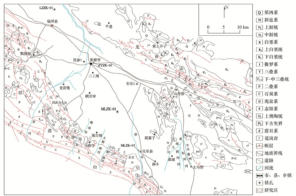
Geological structure map of research area
|
|
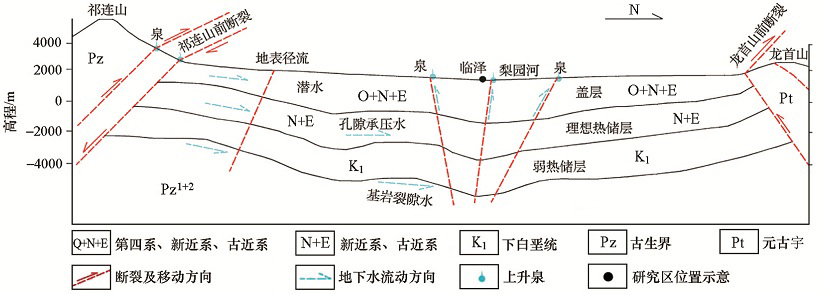
Pattern diagram of groundwater recharge in the study area
|

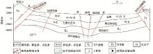
| 地层 | 岩性 | 电阻率/(Ω·m) | | 砾石 | 400 | | 砂质黏土 | 150 | | 第四系(Q) | 粉砂 | 160 | | 细砂 | 180 | | 中砂 | 210 | 新近系、古近系
(N+E) | 泥岩 | 124 | | 砂质泥岩 | 140 | | 含砾泥岩 | 160 | | 粉砂岩 | 150 | | 细粒砂岩 | 170 | | 中粒砂岩 | 180 | | 粗粒砂岩 | 170 | | 砾岩 | 150 | | 上奥陶统(O3) | 花岗岩 | 190 |
|
Physical characteristics of the research area
|
|
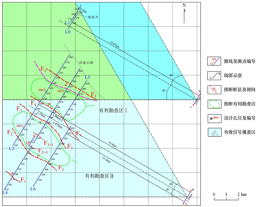
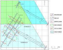
Geophysical job layout and comprehensive results plane
|
|
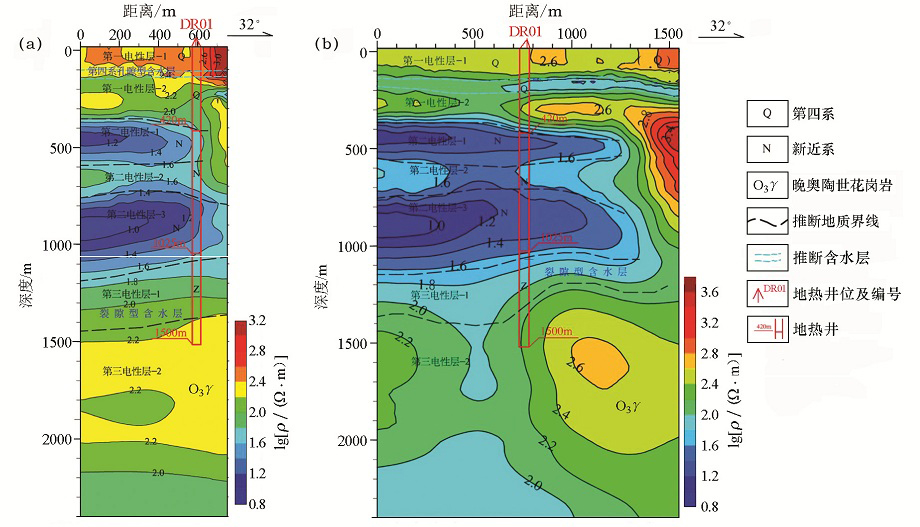
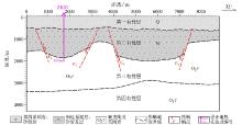
1D continuous media inversion and interpretation sections of apparent resistivity for survey line L0(a) and L1(b)
|
|
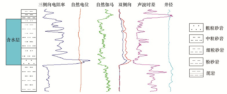
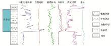
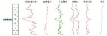
Well logging curve characteristics of porous rock aquifer
|
|
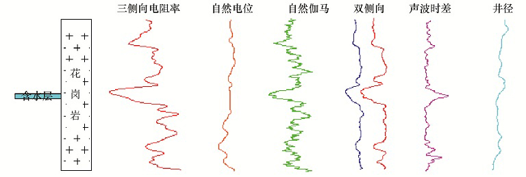
Well logging curve characteristics of fractured aquifer
|
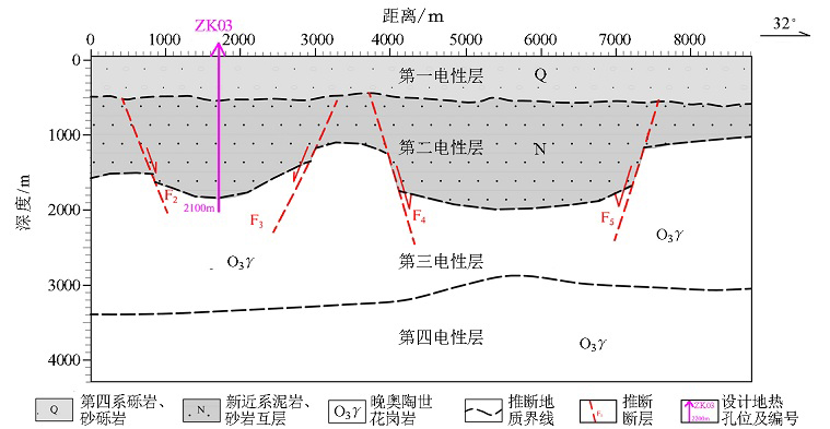
| 序号 | 地层 | 深度/m | 厚度/m | 岩性特征 | | 1 | 第四系(Q) | 420 | 420 | 卵砾石、砂砾石、中砂、细砂、黏土、亚黏土及亚砂土 | | 2 | 新近系、古近系(N+E) | 1025 | 605 | 上部灰黄色、土黄色泥岩,砂质泥岩,中、细砂岩及砾岩,半胶结状,可见钙质成分;下部浅棕色、灰黄色泥岩、砂岩、砂质泥岩、杂色砂砾岩,半固结状;底部风化带为浅灰棕色、灰黄色泥岩夹杂色花岗岩 | | 3 | 上奥陶统(O3) | 1500 | 475 | 肉红色、灰青色、浅白色花岗岩,上部裂隙较发育,下部较致密 |
|
Stratigraphic survey of geothermal well
|
|
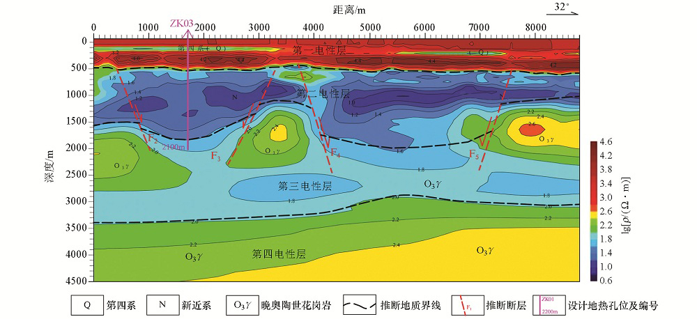
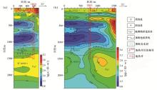
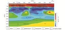
1D continuous media inversion and inter pretation section for survey line 2
|
|
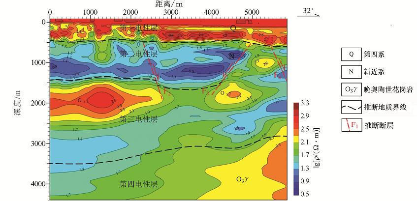
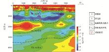
1D continuous media inversion and inter pretation section for survey line 6
|
|
Comprehensive geological interpretation of survey line 2
|

|
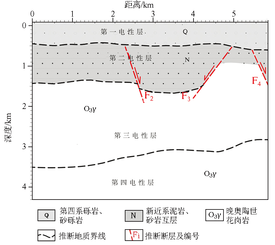
Comprehensive geological interpretation of survey line 6
|
">
|
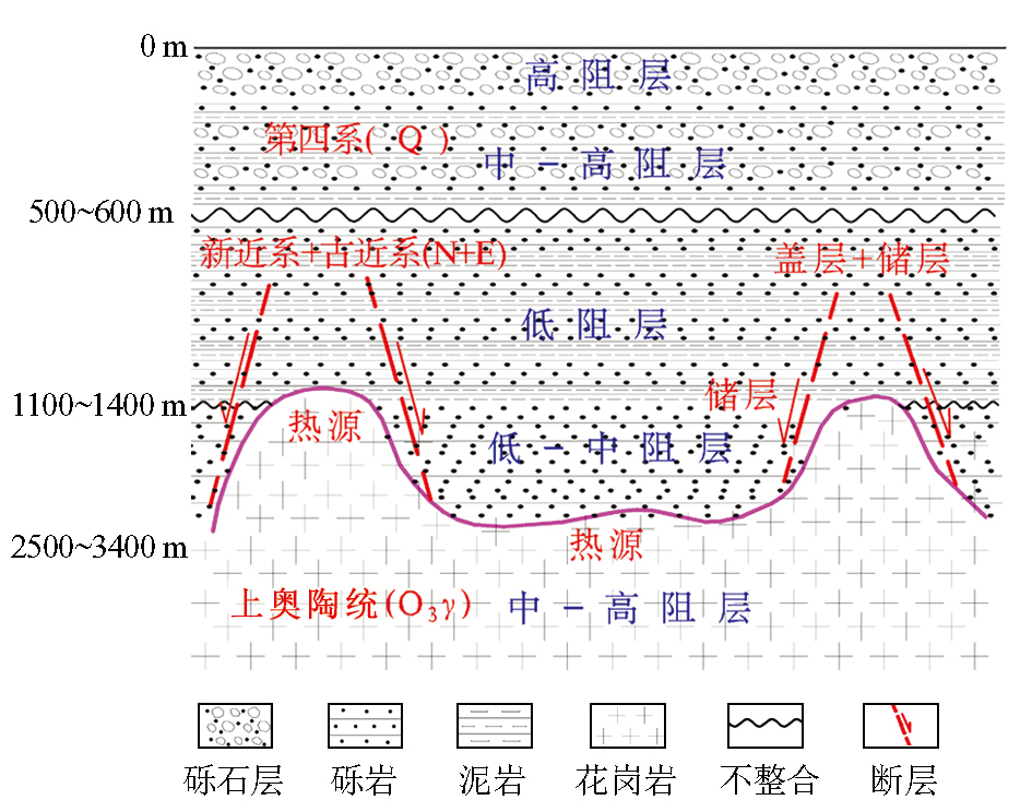
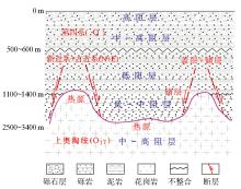
"Geology-Geophysical-Geothermal" model building of the research area
|
| [1] |
中国石油地质志编委会. 中国石油地质志玉门卷[M]. 北京: 石油工业出版社, 1989.
|
| [1] |
China Petroleum Geology Editorial Board. China petroleum geology journal Yumen volume [M]. Beijing: Petroleum Industry Press, 1989.
|
| [2] |
刘兴春. 民乐山前平原新构造运动及其对地下水埋藏的影响[J]. 甘肃地质学报, 2000,9(1):74-79.
|
| [2] |
Liu X C. Neo-tectonic movement of the Minle Piedmont Plain and its impact on groundwater burial[J]. Acta Geologica Gansu, 2000,9(1):74-79.
|
| [3] |
赵聚林, 刘多朝. 概论祁连山前民乐盆地隐伏构造、第四系及地下水——依据1:10万综合电法成果[J]. 甘肃地质学报, 2005,14(1):82-85.
|
| [3] |
Zhao J L, Liu D C. The hidden faults and quaternary system of Minle basin in front of the Qilian mountain[J]. Acta Geologica Gansu, 2005,14(1):82-85.
|
| [4] |
俞兆虎, 滕汉仁, 李百祥. 张掖—民乐盆地地质—地球物理信息揭示的地热资源前景与勘查方法优化组合[J]. 甘肃地质, 2018,27(s1):79-84.
|
| [4] |
Yu Z H, Teng H R, Li B X. On geothermal resource potential and optimization prospecting methods in terms of geology-geophysical information in Zhangye-Minle basin[J]. Gansu Geology, 2018,27(s1):79-84.
|
| [5] |
张振杰, 李兴海, 胡潇. 综合物探方法在张掖城区及外围深部地热资源勘查中的应用研究[J]. 地下水, 2018,40(4):52-54.
|
| [5] |
Zhang Z J, Li X H, Hu X. Application of comprehensive geophysical methods in the exploration of deep geothermal resources in Zhangye city and its periphery[J] . Groundwater, 2018,40(4):52-54.
|
| [6] |
何继善. 广域电磁法和伪随机信号电法[M]. 北京: 高等教育出版社, 2010.
|
| [6] |
He J S. Wide area electromagnetic method and pseudo-random signal electrical method[M]. Beijing: Higher Education Press, 2010.
|
| [7] |
何继善. 广域电磁测深法研究[J]. 中南大学学报:自然科学版, 2010,41(3):1065-1072.
|
| [7] |
He J S. Wide field electromagnetic sounding methods[J]. Journal of Central South University:Science and Technology, 2010,41(3):1065-1072.
|
| [8] |
李帝铨, 胡艳芳. 强干扰矿区中广域电磁法与CSAMT探测效果对比[J]. 物探与化探, 2015,39(5):967-972.

|
| [8] |
Li D Q, Hu Y F. A comparison of wide field electromagnetic method with CSAMT method in strong interferential mining area[J]. Geophysical and Geochemical Exploration, 2015,39(5):967-972.
|
| [9] |
朱裕振, 许聪悦. 广域电磁法深部找矿实验效果[J]. 物探与化探, 2011,35(6):743-746.
|
| [9] |
Zhu Y Z, Xu C Y. The experimental application of wider field electromagnetic method to the prospectiang for deep ore deposits[J]. Geophysical and Geochemical Exploration, 2011,35(6):743-746.
|
| [10] |
凌帆, 朱裕振, 周明磊, 等. 广域电磁法在南华北盆地长山隆起页岩气资源潜力评价中的应用[J]. 物探与化探, 2017,41(2):369-376.
|
| [10] |
Ling F, Zhu Y Z, Zhou M L, et al. Shale gas potential assessment of Changsan uplift area in southern North China basin by using wide field electromagnetic method[J]. Geophysical and Geochemical Exploration, 2017,41(2):369-376.
|
| [11] |
曹彦荣, 宋涛, 韩红庆, 等. 用广域电磁法勘查深层地热资源[J]. 物探与化探, 2017,41(4):678-683.
|
| [11] |
Cao Y R, Song T, Han H Q, et al. Exploration of deep geothermal energy resources with wide field electromagnetic method[J]. Geophysical and Geochemical Exploration, 2017,41(4):678-683.
|
| [12] |
孙求实, 袁杰, 宗文明, 等. 广域电磁法在辽西地区牛营子凹陷油气资源潜力评价中的应用[J]. 物探与化探, 2019,34(1):64-69.
|
| [12] |
Sun Q S, Yuan J, Zong W M, et al. The application of wide field electromagnetic method to the oil and gas exploration of Niuyingzi sag in Liaoxi area[J]. Geophysical and Geochemical Exploration, 2019,43(1):64-69.
|
| [13] |
郑文俊. 河西走廊及其邻区活动构造图像及构造变形模式[D]. 北京:中国地震局地质研究所, 2009.
|
| [13] |
Zheng W J. Active tectonic image and tectonic deformation model of Hexi Corridor and its adjacent area [D]. Beijing: Institute of Geology, China Earthquake Administration, 2009.
|
| [14] |
陈文彬. 河西走廊及邻近地区最新构造变形基本特征及构造成因分析[D]. 北京:中国地震局地质研究所, 2003.
|
| [14] |
Chen W B. Analysis of the latest tectonic characteristics and tectonic genesis of the Hexi Corridor and its adjacent areas[D]. Beijing: Institute of Geology, China Earthquake Administration, 2003.
|
| [15] |
魏红军, 李百祥. 张掖—民乐盆地地质构造特征与张掖市地热资源开发可行性分析[J]. 甘肃地质, 2007(4):73-76,84.
|
| [15] |
Wei H J, Li B X. Characteristics of geological structures in Zhangye-Minle basin and feasibility study of Geothermal resources in Zhangye city[J]. Gansu Geology, 2007(4):73-76,84.
|
| [16] |
谭美娟. 河西走廊榆木山东麓第四纪地层研究[D]. 北京: 中国地质大学(北京), 2016.
|
| [16] |
Tan M J. Quaternary stratigraphy of the eastern foot of Elm in the Hexi Corridor[D]. Beijing: China University of Geosciences (Beijing), 2016.
|
| [17] |
丁宏伟, 张举. 河西走廊深层地下水的赋存和开发[J]. 西北地质, 2009,42(3):109-119.
|
| [17] |
Ding H W, Zhang J. Occurrence and development of deep underground water in Hexi Corridor[J]. Northwestern Geology, 2009,42(3):109-119.
|
| [18] |
张光辉, 刘少玉, 张翠云, 等. 黑河流域地下水循环演化规律研究[J]. 中国地质, 2004,31(3):289-293.
|
| [18] |
Zhang G H, Liu S Y, Zhang C Y, et al. Evolution of groundwater circulation in the Heihe river drainage area[J]. Geology in China, 2004,31(3):289-293.
|
|
|
|