|
|
|
| The application of comprehensive geophysical method to the exploration of uranium deposits in the paleo-Shibei area of Shanghang Basin |
LI Ying-Bin1,2( ), XIE Ming-Hong1,2, ZHANG Zhan-Bin1,2, LI Yi1,2, WEI Bin1,2, ZHANG Wei1,2 ), XIE Ming-Hong1,2, ZHANG Zhan-Bin1,2, LI Yi1,2, WEI Bin1,2, ZHANG Wei1,2 |
1. Airborne Survey and Remote Sensing Center of Nuclear Industry, Shijiazhuang 050002, China
2. Key Laboratory of Uranium Resources Geophysical Exploration Technology, China Nuclear Industry Group Company, Shijiazhuang 050002, China |
|
|
|
|
Abstract The paleo-Shibei area has a good geological background of uranium mineralization, and some mineralization spots and uranium anomalies have been found. The previous work was mainly focused on the surrounding and shallow parts of the mineralization spots, and the evaluation of the overall metallogenic environment and the understanding of the deep metallogenic conditions in the study area were insufficient. The authors briefly introduced the working methods of soil radon, ground gamma energy spectrum and audio frequency magnetotelluric survey, analyzed the uranium metallogenic environment in the study area by comprehensive geophysical survey, delineated the approximate position of uranium ore anomaly on the surface by carrying out soil radon and ground gamma energy spectrum survey, and found the paleo-rock back of ore-controlling fault by carrying out audio frequency magnetotelluric survey (AMT). The characteristics of the development of the fault and ore-controlling strata of Shimaoshan Group were determined, and the inferred interpretation data were verified by drilling, which provides a reference for the exploration of this type of uranium deposits.
|
|
Received: 15 January 2020
Published: 29 December 2020
|
|
|
|
|
|
|
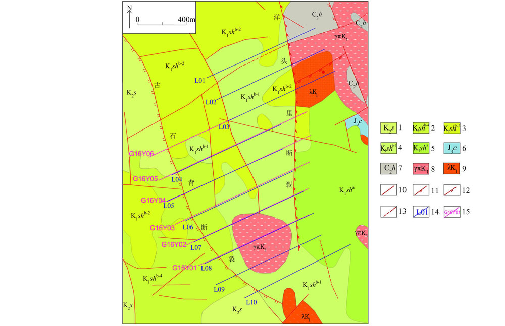
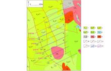
Geological and survey line layout of the study area
1—upper Cretaceous; 2—lower Cretaceous fine-grained rhyolite; 3—lower Cretaceous biotite rhyolite; 4—lower Cretaceous tuffaceous sandstone; 5—lower Cretaceous andesite; 6—upper Jurassic dolomitic limestone; 7—upper Carboniferous sandstone conglomerate; 8—yanshanian granite porphyry; 9—yanshanian sub rhyolite; 10—measured fault; 11—compression torsion fault; 12—tensile fault; 13—inferred fault; 14—ground gamma energy spectrum, soil radon line and its number; 15—AMT line and its number
|

| 线号 | 点数 | | | | | | L01 | 50 | 123.78 | 2.36 | 9.86 | 55.96 | 17.33 | 29.83 | 12.6 | 0.47 | 3.66 | | L02 | 50 | 18.29 | 1.9 | 4.58 | 13.64 | 40.93 | 24.74 | 6.85 | 0.58 | 2.68 | | L03 | 50 | 34.69 | 2.39 | 12.39 | 38.12 | 16.61 | 27.69 | 2.73 | 0.46 | 1.33 | | L04 | 50 | 30.76 | 1.07 | 4.9 | 47.77 | 24.01 | 35.85 | 7.98 | 0.25 | 1.82 | | L05 | 60 | 45 | 2 | 7.09 | 39.9 | 17.8 | 28.79 | 7.2 | 0.7 | 2.06 | | L06 | 49 | 32.5 | 1.7 | 4.69 | 40.42 | 8.22 | 22.35 | 9.15 | 1.33 | 4.09 | | L07 | 50 | 14.87 | 1.86 | 5.73 | 41.07 | 6.41 | 21.22 | 4.77 | 0.89 | 2.62 | | L08 | 49 | 22.76 | 1.81 | 6.20 | 45.01 | 9.16 | 20.08 | 3.87 | 0.63 | 2.06 | | L09 | 50 | 10.8 | 1.57 | 4.23 | 43.33 | 9.05 | 17.52 | 4.27 | 1.07 | 2.34 | | L10 | 50 | 18.63 | 2.37 | 8.19 | 34.11 | 7.84 | 15.03 | 6.83 | 0.26 | 2.48 |
|
Statistical table of ground gamma spectrum measurement results
|
|
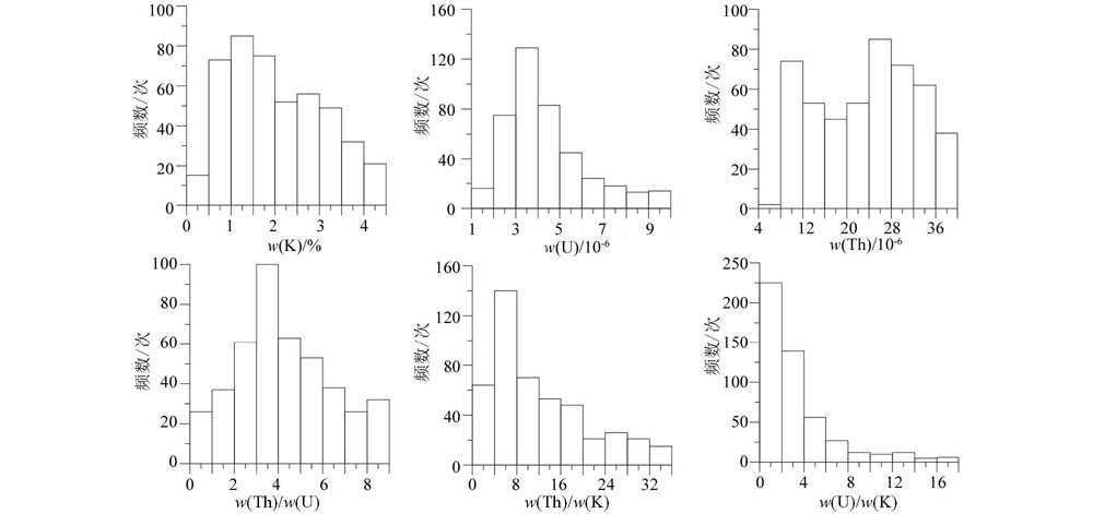
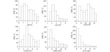
Distribution histogram of K, U, Th and their ratio of ground gamma spectrum in the study area
|
|
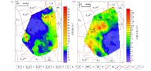
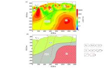
Isopleth map of activated uranium (a) and paleouranium abundance (b) in the study area
1—upper Cretaceous; 2—lower Cretaceous fine-grained rhyolite; 3—lower Cretaceous biotite rhyolite; 4—lower Cretaceous tuffaceous sandstone; 5—lower Cretaceous andesite; 6—upper Jurassic dolomitic limestone; 7—upper Carboniferous sandstone conglomerate; 8—yanshanian granite porphyry; 9—yanshanian sub rhyolite; 10—measured fault; 11—compression torsion fault; 12—tensile fault; 13—speculative fault
|
| w(U)/10-6 | w(Th)/10-6 | w(K)/% | w(Rn)/(Bq·m-3) | | 背景值(X) | 5.04 | 24.38 | 2.24 | 3560 | | 标准偏差(S) | 2.74 | 9.67 | 1.28 | 1400 | | 变异系数(Cv) | 0.54 | 0.40 | 0.57 | 0.39 | | 偏高晕下限(X+S) | 7.78 | 34.05 | 3.52 | 4960 | | 高晕下限(X+2S) | 10.52 | 43.72 | 4.8 | 6360 | | 异常晕下限(X+3S) | 13.26 | 53.39 | 6.08 | 7760 |
|
Statistical table of ground gamma spectrum and soil radon measurement data in the study area
|

|
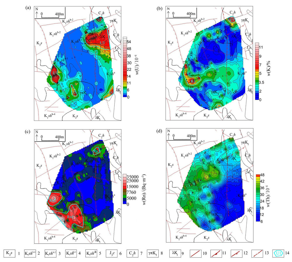
Study area U, K, RN, Th contour plan
1—upper Cretaceous; 2—lower Cretaceous fine-grained rhyolite; 3—lower Cretaceous biotite rhyolite; 4—lower Cretaceous tuffaceous sandstone; 5—lower Cretaceous andesite; 6—upper Jurassic dolomitic limestone; 7—upper Carboniferous sandstone conglomerate; 8—yanshanian granite porphyry; 9—yanshanian sub rhyolite; 10—measured fault; 11—compression torsion fault; 12—tensile fault; 13—inferred fault; 14—circle abnormal halo and its number
|

|
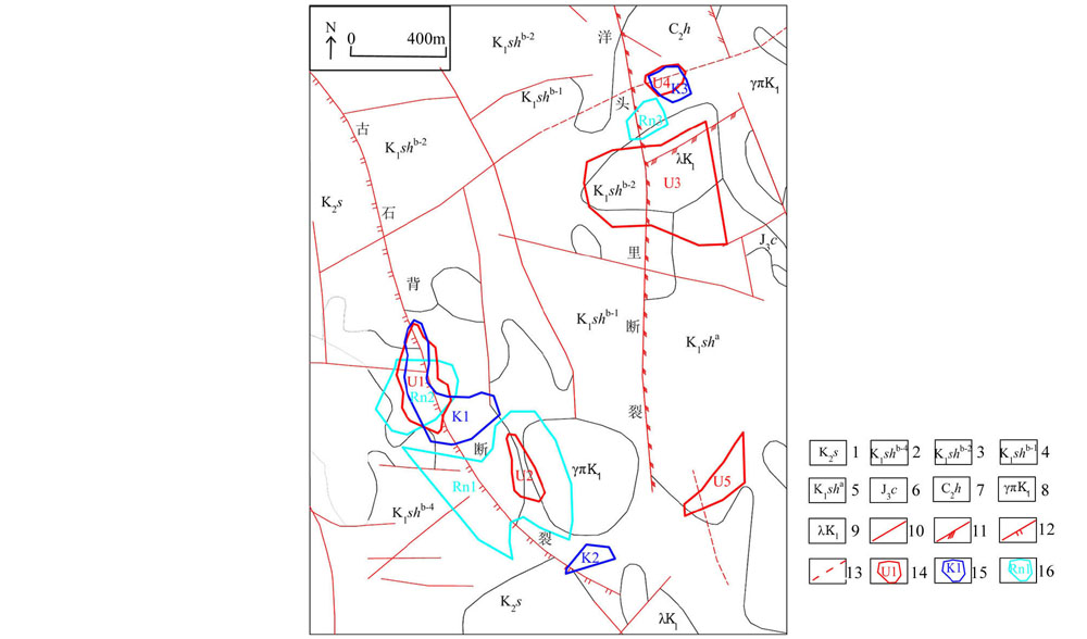
Composite anomaly halo map of comprehensive geophysical exploration in the paleoshibei area
1—upper Cretaceous; 2—lower Cretaceous fine-grained rhyolite; 3—lower Cretaceous biotite rhyolite; 4—lower Cretaceous tuffaceous sandstone; 5—lower Cretaceous andesite; 6—upper Jurassic dolomitic limestone; 7—upper Carboniferous sandstone conglomerate; 8—yanshanian granite porphyry; 9—yanshanian sub rhyolite; 10—measured fault; 11—compression torsion fault; 12—tensile fault; 13—inferred fault; 14—circle U abnormal halo and its serial number; 15—circle K abnormal halo and its serial number; 16—circle Rn abnormal halo and its serial number
|
| 地层 | 岩性 | 代号 | 测量数(组) | 电阻率/(Ω·m) | | 测量值范围 | 常见值范围 | 平均值 | | 沙县组 | 泥岩 | K2s | 30 | 23~99 | 23~54 | 36 | | 石帽山群 | 流纹岩 | K1shb-4 | 34 | 403~1214 | 403~645 | 515 | | 凝灰质细砂岩 | K1s | 30 | 63~365 | 98~240 | 167 | | 凝灰质砂岩 | K1shb-1 | 31 | 130~259 | 130~259 | 180 | | 安山岩 | K1sha | 32 | 199~646 | 260~455 | 355 | | 长林组 | 砾岩 | J3c | 31 | 135~487 | 170~350 | 253 | | 黄龙组 | 灰岩 | C2h | 31 | 91~418 | 167~322 | 256 | | 燕山期花岗斑岩 | γ | 31 | 103~1674 | 584~1175 | 800 |
|
Statistical table of measurement results of electrical parameters of rock
|
|
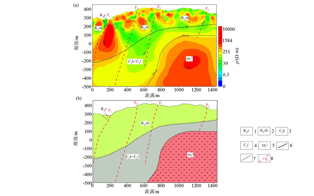
Interpretation map (b)of inversion resistivity section (a)of G16Y05 line
1—Shaxian formation: calcareous mudstone, siltstone, glutenite; 2—Shimaoshan group: rhyolite, tuffaceous sandstone, dacite, andesite, etc.; 3—Huanglong formation: gray white dolomitic limestone, siliceous rock; 4—Woodland formation: Quartz conglomerate, glutenite, coarse sandstone with siltstone, shale; 5—granite porphyry; 6—inferred unconformity contact boundary; 7—inferred lithology contact boundary; 8—inferred fault and number
|
|
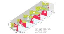
Comprehensive diagram of geological inference and interpretation in ancient Shibei area
1—Shaxian formation: calcareous mudstone, siltstone, glutenite; 2—Shimaoshan group: rhyolite, tuffaceous sandstone, dacite, andesite, etc.; 3—Huanglong formation: gray white dolomitic limestone, siliceous rock+Woodland formation: Quartz conglomerate, glutenite, coarse sandstone with siltstone, shale; 4—granite porphyry; 5—inferred unconformity contact boundary; 6—inferred lithology contact boundary; 7—inferred fault and number
|
|
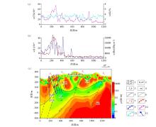
Comprehensive interpretation map of U, K, Th, Rn concentration profile of line L05 (a)(b) and inversion resistivity profile of line G16Y04 (c)
1—tuffaceous sandstone of Shimaoshan group; 2—andesite of Shimaoshan group; 3—Huanglong formation; 4—granite porphyry; 5—inferred unconformity contact boundary; 6—inferred lithology contact boundary; 7—inferred fault and number; 8—uranium content curve; 9—radon concentration curve; 10—potassium content curve; 11—thorium content curve; 12—borehole
|
| [1] |
林东燕, 陈郑辉. 福建上杭拉分盆地与紫金山铜金矿床成矿关系.[J]. 西安科技大学学报, 2011,31(4):438-441.
|
| [1] |
Lin D Y, Chen Z H. Metallogenic relationship between Shanghang pull apart basin and Zijinshan copper gold deposit, Fujian Province[J]. Journal of Xi’an University of Science and Technology. 2011,31(4):438-441.
|
| [2] |
王善雄, 林东燕. 福建中西部断裂活动与断陷盆地演化的初步研究——以上杭盆地为例[J]. 福建地震, 1998,14(4):37-39.
|
| [2] |
Wang S X, Lin D Y. A preliminary study on the fault activity and the evolution of fault basin in the central and Western Fujian Province[J]. Fujian Earthquake, 1998,14(4):37-39.
|
| [3] |
潘天望, 袁远, 吕勇, 等. 福建紫金山矿田早白垩世以来构造演化和成岩成矿时空格架[J]. 地质力学学报, 2019,25(1):61-76.
|
| [3] |
Pan T W, Yuan Y, Lyu Y, et al. The early-cretaceous tectonic evolution and the spatial-temporal framework of magmatism-mineralization in Zijinshan ore-field,Fujian province[J]. Journal of Geomechanics, 2019,25(1):61-76.
|
| [4] |
曹秋义, 山亚, 张恩, 等. 地面伽马能谱测量在铀矿找矿中的应用研究——以黑龙江省嘉荫县磨石山地区为例[J]. 物探与化探, 2016,40(4):701-704.

|
| [4] |
Cao Q Y, Shan Y, Zhang E, et al. Application of ground gamma spectrometry measurements of uranium prospecting[J]. Geophysical and Geochemical Exploration, 2016,40(4):701-704.
|
| [5] |
杜化宇, 李晓禄, 伍显红. 放射性测量方法在马鬃山地区铀金找矿中的应用效果[J]. 物探与化探, 2018,42(4):697-702.
|
| [5] |
Du H Y, Li X L, Wu X H. The effect of radioactive measurement for uranium and gold prospecting in Mazong Mountain area[J]. Geophysical and Geochemical Exploration, 2018,42(4):697-702.
|
| [6] |
高峰, 张寿庭, 邹灏, 等. 地面伽马能谱测量在内蒙古林西地区萤石矿找矿中的应用[J]. 物探与化探, 2013,37(2):206-211.
|
| [6] |
Gao F, Zhang S T, Zou H, et al. The application of field gamma ray spectrometry to the prospecting for fluorite deposits in LingXi area of inner Mongolia[J]. Geophysical and Geochemical Exploration, 2013,42(4):206-211.
|
| [7] |
康贤, 苟润祥, 李耕. 地面伽玛能谱测量寻找盐湖型钾盐矿的应用研究[J]. 铀矿地质, 2005,21(1):45-51.
|
| [7] |
Kang X, Gou R X, Li G. Application of ground gamma-ray spectrometric survey to prospecting for salt lake-type potashdeposits[J]. Uranium Geology, 2005,21(1):45-51.
|
| [8] |
刘菁华, 王祝文, 田钢, 等. 地面伽玛能谱测量在浅覆盖区地质填图中的应用[J]. 地质与勘探, 2003,39(2):61-64.
|
| [8] |
Liu J H, Wang Z W, Tian G, et al. Application of ground gamma-spectometry in geological mapping in shallow overburden areas[J]. Geology and Exploration, 2003,39(2):61-64.
|
| [9] |
叶益信, 邓居智, 方根显. 高频大地电磁测深(EH-4)在热储构造勘查中的试验研究——以抚州地热区为例[J]. 地质与勘探, 2011,47(4):649-653.
|
| [9] |
Ye Y X, Deng J Z, Fang G X. The test research of high frequency magnetotelluric sounding to reservoir structure survey: taking the Fuzhou geothermal area in Jiangxi province as an example[J]. Geology and Exploration, 2011,47(4):649-653.
|
| [10] |
席振铢, 冯万杰, 李瑞雪, 等. 低阻覆盖层对高频大地电磁测深的影响[J]. 地质与勘探, 2011,47(4):673-678.
|
| [10] |
Xi Z Z, Feng W J, Li R X, et al. Effect of a low-resistivity cover on high-frequency magnetotelluric sounding[J]. Geology and Exploration, 2011,47(4):673-678.
|
| [11] |
王斌, 陈孝强, 樊战军, 等. EH-4连续电导率仪在陕西省镇安县金龙山矿区控矿构造研究中的应用[J]. 地质与勘探, 2014,50(3):564-571.
|
| [11] |
Wang B, Chen X Q, Fan Z J, et al. Application of EH-4 continuous conductivitymeter to the study of ore-controlling structures in the Jinlongshan gold deposit of Zhen’ancountry,Shaanxi Province[J]. Geology and Exploration, 2014,50(3):564-571.
|
| [12] |
谭红艳, 吕骏超, 刘桂香, 等. EH-4 音频大地电磁测深方法在鄂东南地区寻找隐伏矿体的应用[J]. 地质与勘探, 2011,47(6):1133-1141.
|
| [12] |
Tan H Y, Lyu J C, Liu G X, et al. Application of the EH-4 audio-frequency magnetotelluric method to search for concealed ore bodies in southeastern Hubei Province[J]. Geology and Exploration, 2011,47(6):1133-1141.
|
| [13] |
柳建新, 童孝忠, 程云涛, 等. 有效视电阻率在音频大地测量数据二维反演中的应用[J]. 地质与勘探, 2008,44(3):56-59.
|
| [13] |
Liu J X, Tong X Z, Cheng Y T, et al. Application ofeffective appar ent resistivity in two-dimensional inversion of EH-4 date[J]. Geology and Exploration, 2008,44(3):56-59.
|
| [14] |
张作伦, 曾庆, 刘建明, 等. GDP-32II、EH-4在深部成矿预测中的应用[J]. 地质与勘探, 2010,46(3):470-475.
|
| [14] |
Zhang Z L, Zeng Q, Liu J M, et al. Application of GDP-32IIand EH-4 to prediction of mineralization at depth[J]. Geology and Exploration, 2010,46(3):470-475.
|
| [15] |
王少怀, 裴荣富, 曾宪辉, 等. 再论紫金山矿田成矿系列与成矿模式[J]. 地质学报, 2009,83(2):145-155.
|
| [15] |
Wang S H, Pei R F, Zeng X H, et al. Further discussion on metallogenic series and metallogenic model of Zijinshan ore field[J]. Journal of Geology, 2009,83(2):145-155.
|
| [1] |
LI Di-Quan, XIAO Jiao-Yu, ZHANG Ji-Feng, HU Yan-Fang, LIU Zui-Liang, ZHANG Xin. Comparison of application effects of WFEM and CSAMT in water-rich area of Xinyuan Coal Mine[J]. Geophysical and Geochemical Exploration, 2021, 45(5): 1359-1366. |
| [2] |
YU Yong-Peng, YAN Zhao-Tao, MAO Xing-Jun, YANG Yan-Cheng, MA Yong-Xiang, HUANG Peng-Cheng, LU Ai-Guo, ZHANG Guang-Bing. The application of the comprehensive electric and seismic method to coal exploration in the huge Cenozoic coverage area[J]. Geophysical and Geochemical Exploration, 2021, 45(5): 1231-1238. |
|
|
|
|