|
|
|
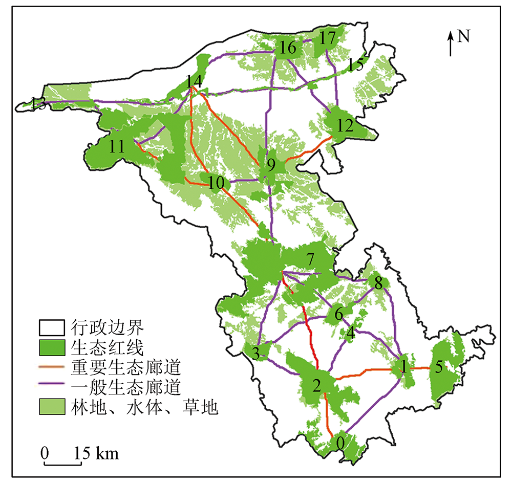
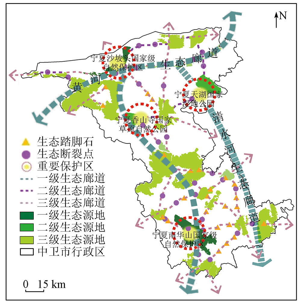
Abstract Based on data from multiple sources including Landsat8 OLI_TIRS remote sensing images, digital elevation model (DEM), road networks, and water system, as well as the corrected energy factor model and gravity model, this study improved the method for ecological network construction based on morphological spatial pattern analysis (MSPA) and the minimum cumulative resistance (MCR) model. Using the method, this study constructed and optimized a hierarchical ecological network for Zhongwei City, Ningxia. The results show that: ① The identification of ecological source areas in arid regions should be conducted using the data of woodland, grassland, and water bodies as foreground data and woodland and selecting ecological source areas based on ecological redlines; ② The ecological network of Zhongwei City presents a spatial structure mode characterized by four cores, three first-level ecological corridors, and multiple minor ecological source areas. Seventeen ecological source areas were identified, accounting for 22.33% of the study area. Among them, four grade-1 and -2 source areas exhibited significantly high energy factors, forming four cores. A total of 33 potential ecological corridors were identified, including three grade-1 ecological corridors; ③ Strategies for optimizing the ecological network, including improving ecological source areas’ quality, enhancing corridors, and restoring ecological breaking points. Except for the stable corridors connecting Nos. 1, 7, and 9 source areas, other source areas manifest poor connectivity, leading to low ecological network stability. Therefore, it is necessary to establish 24 ecological stepping stones. Furthermore, 38 ecological breaking points requiring urgent restoration were discovered; (4) The optimized ecological network demonstrates enhanced stability, with α, β, and γ indices elevated at 9.5%, 3.8%, and 4.2%, respectively. This network will promote the flow of ecological materials/information and biodiversity conservation.
|
| Keywords
morphological spatial pattern analysis (MSPA)
minimum cumulative resistance (MCR) model
hierarchical ecological network
arid region
upper reaches of the Yellow River
|
|
|
|
Issue Date: 13 March 2024
|
|
|
| [1] |
徐伟振, 黄思颖, 耿建伟, 等. 基于MCR和重力模型下的厦门市生态空间网络构建[J]. 西北林学院学报, 2022, 37(2):264-272.
|
| [1] |
Xu W Z, Huang S Y, Geng J W, et al. Construction of ecological space network in Xiamen City based on MCR and gravity model[J]. Journal of Northwest Forestry University, 2022, 37(2):264-272.
|
| [2] |
高宇, 木皓可, 张云路, 等. 基于MSPA分析方法的市域尺度绿色网络体系构建路径优化研究——以招远市为例[J]. 生态学报, 2019, 39(20): 7547-7556.
|
| [2] |
Gao Y, Mu H K, Zhang Y L, et al. Research on construction path optimization of urban-scale green network system based on MSPA analysis method: Taking Zhaoyuan City as an example[J]. Acta Ecologica Sinica, 2019, 39(20): 7547-7556.
|
| [3] |
张晴, 郭志威, 齐开, 等. 基于MSPA和MCR模型的襄阳市生态网络变化研究[J]. 湖北大学学报(自然科学版), 2022, 44(2): 162-170.
|
| [3] |
Zhang Q, Guo Z W, Qi K, et al. Variation of ecological network in Xiangyang City based on MSPA and MCR model[J]. Journal of Hubei University(Natural Science), 2022, 44(2): 162-170.
|
| [4] |
曲艺, 陆明. 生态网络规划研究进展与发展趋势[J]. 城市发展研究, 2016, 23(8): 29-36.
|
| [4] |
Qu Y, Lu M. Research progress and development trend of ecological network planning[J]. Urban Development Studies, 2016, 23(8): 29-36.
|
| [5] |
周振宏, 王绘绘, 朱庆山, 等. 马鞍山市生态网络识别与优化[J]. 安徽师范大学学报(自然科学版), 2022, 45(1): 35-41.
|
| [5] |
Zhou Z H, Wang H H, Zhu Q S, et al. Identification and optimization of ecological network in Ma’anshan City[J]. Journal of Anhui Normal University (Natural Science), 2022, 45(1): 35-41.
|
| [6] |
陈昕, 彭建, 刘焱序, 等. 基于“重要性-敏感性-连通性”框架的云浮市生态安全格局构建[J]. 地理研究, 2017, 36(3):471-484.
doi: 10.11821/dlyj201703006
|
| [6] |
Chen X, Peng J, Liu Y X, et al. Constructing ecological security patterns in Yunfu City based on the framework of importance-Sensitivity-Connectivity[J]. Geographical Research, 2017, 36(3):471-484.
doi: 10.11821/dlyj201703006
|
| [7] |
陈南南, 康帅直, 赵永华, 等. 基于MSPA和MC模型的秦岭(陕西段)山地生态网络构建[J]. 应用生态学报, 2021, 32(5): 1545-1553.
doi: 10.13287/j.1001-9332.202105.012
|
| [7] |
Chen N N, Kang S Z, Zhao Y H, et al. Construction of ecological network in Qinling Mountains of Shaanxi,China based on MSPA and MCR model[J]. Chinese Journal of Applied Ecology, 2021, 32(5): 1545-1553.
|
| [8] |
张启舜, 李飞雪, 王帝文, 等. 基于生态网络的江苏省生态空间连通性变化研究[J]. 生态学报, 2021, 41(8): 3007-3020.
|
| [8] |
Zhang Q S, Li F X, Wang D W, et al. Analysis on changes of ecological spatial connectivity in Jiangsu Province based on ecological network[J]. Acta Ecologica Sinica, 2021, 41(8): 3007-3020.
|
| [9] |
宋利利, 秦明周, 张鹏岩, 等. 基于图论的景观图表达、分析及应用[J]. 应用生态学报, 2020, 31(10): 3579-3588.
doi: 10.13287/j.1001-9332.202010.014
|
| [9] |
Song L L, Qin M Z, Zhang P Y, et al. Representation,analysis and application of landscape graph based on graph theory[J]. Chinese Journal of Applied Ecology, 2020, 31(10): 3579-3588.
|
| [10] |
沈钦炜, 林美玲, 莫惠萍, 等. 佛山市生态网络构建及优化[J]. 应用生态学报, 2021, 32(9): 3288-3298.
doi: 10.13287/j.1001-9332.202109.019
|
| [10] |
Shen Q W, Lin M L, Mo H P, et al. Ecological network construction and optimization in Foshan City,China[J]. Chinese Journal of Applied Ecology, 2021, 32(9): 3288-3298.
|
| [11] |
黄河, 余坤勇, 高雅玲, 等. 基于MSPA的福州绿色基础设施网络构建[J]. 中国园林, 2019, 35(11): 70-75.
|
| [11] |
Huang H, Yu K Y, Gao Y L, et al. Building green infrastructure network of Fuzhou using MSPA[J]. Chinese Landscape Architecture, 2019, 35(11): 70-75.
|
| [12] |
彭建, 赵会娟, 刘焱序, 等. 区域生态安全格局构建研究进展与展望[J]. 地理研究, 2017, 36(3): 407-419.
doi: 10.11821/dlyj201703001
|
| [12] |
Peng J, Zhao H J, Liu Y X, et al. Research progress and prospect on regional ecological security pattern construction[J]. Geographical Research, 2017, 36(3): 407-419.
doi: 10.11821/dlyj201703001
|
| [13] |
王雪然, 万荣荣, 潘佩佩. 太湖流域生态安全格局构建与调控——基于空间形态学-最小累积阻力模型[J]. 生态学报, 2022, 42(5): 1968-1980.
|
| [13] |
Wang X R, Wan R R, Pan P P. Construction and adjustment of ecological security pattern based on MSPA-MCR model in Taihu Lake basin[J]. Acta Ecologica Sinica, 2022, 42(5): 1968-1980.
|
| [14] |
王玉莹, 金晓斌, 沈春竹, 等. 东部发达区生态安全格局构建——以苏南地区为例[J]. 生态学报, 2019, 39(7): 2298-2310.
|
| [14] |
Wang Y Y, Jin X B, Shen C Z, et al. Establishment of an ecological security pattern in the eastern developed regions:A case study of the Sunan District[J]. Acta Ecologica Sinica, 2019, 39(7): 2298-2310.
|
| [15] |
朱捷, 苏杰, 尹海伟, 等. 基于源地综合识别与多尺度嵌套的徐州生态网络构建[J]. 自然资源学报, 2020, 35(8): 1986-2001.
doi: 10.31497/zrzyxb.20200817
|
| [15] |
Zhu J, Su J, Yin H W, et al. Construction of Xuzhou ecological network based on comprehensive sources identification and multi-scale nesting[J]. Journal of Natural Resources, 2020, 35(8): 1986-2001.
doi: 10.31497/zrzyxb.20200817
|
| [16] |
王戈, 于强, Yang D, 等. 基于复杂网络分析法的层级生态网络结构研究[J]. 农业机械学报, 2019, 50(7): 258-266,312.
|
| [16] |
Wang G, Yu Q, Yang D, et al. Hierarchical ecological network structure based on complex network analysis[J]. Transactions of the Chinese Society for Agricultural Machinery, 2019, 50(7): 258-266,312.
|
| [17] |
姚晓洁, 胡宇, 李久林, 等. 基于“压力-状态-响应模式”的安徽省临泉县生态安全格局构建[J]. 安徽农业大学学报, 2020, 47(4): 538-546.
|
| [17] |
Yao X J, Hu Y, Li J L, et al. Construction of ecological security pattern based on ‘pressure-state-response model’ in Linquan County of Anhui Province[J]. Journal of Anhui Agricultural University, 2020, 47(4): 538-546.
|
| [18] |
Vogt P, Riitters K H, Iwanowski M, et al. Mapping landscape corridors[J]. Ecological Indicators, 2007, 7(2): 481-488.
doi: 10.1016/j.ecolind.2006.11.001
url: https://linkinghub.elsevier.com/retrieve/pii/S1470160X0600094X
|
| [19] |
Vgot P, Ritters K. GudiosToolbox:Universal digital image object analysis[J]. European Journal of Remote Sensing, 2017, 50(1): 352-361
doi: 10.1080/22797254.2017.1330650
url: https://www.tandfonline.com/doi/full/10.1080/22797254.2017.1330650
|
| [20] |
吴昌广, 周志翔, 王鹏程, 等. 景观连接度的概念、度量及其应用[J]. 生态学报, 2010, 30(7): 1903-1910.
|
| [20] |
Wu C G, Zhou Z X, Wang P C, et al. The concept and measurement of landscape connectivity and its applications[J]. Acta Ecologica Sinica, 2010, 30(7): 1903-1910.
|
| [21] |
谢花林, 李秀彬. 基于GIS的农村住区生态重要性空间评价及其分区管制——以兴国县长冈乡为例[J]. 生态学报, 2011, 31(1): 230-238.
|
| [21] |
Xie H L, Li X B. Spatial assessment and zoning regulations of ecological importance based on GIS for rural habitation in Changgang Town,Xingguo County[J]. Acta Ecologica Sinica, 2011, 31(1): 230-238.
|
| [22] |
刘常富, 李京泽, 李小马, 等. 基于模拟景观的城市森林景观格局指数选取[J]. 应用生态学报, 2009, 20(5): 1125-1131.
|
| [22] |
Liu C F, Li J Z, Li X M, et al. Selection of landscape metrics for urban forest based on simulated landscapes[J]. Chinese Journal of Applied Ecology, 2009, 20(5): 1125-1131.
|
| [23] |
陈竹安, 况达, 危小建, 等. 基于MSPA与MCR模型的余江县生态网络构建[J]. 长江流域资源与环境, 2017, 26(8): 1199-1207.
|
| [23] |
Chen Z A, Quang D, Wei X J, et al. Developing ecological networks based on MSPA and MCR: A case study in Yujiang County[J]. Resources and Environment in the Yangtze Basin, 2017, 26(8): 1199-1207.
|
| [24] |
黄木易, 岳文泽, 冯少茹, 等. 基于MCR模型的大别山核心区生态安全格局异质性及优化[J]. 自然资源学报, 2019, 34(4): 771-784.
doi: 10.31497/zrzyxb.20190408
|
| [24] |
Huang M Y, Yue W Z, Feng S R, et al. Analysis of spatial heterogeneity of ecological security based on MCR model and ecological pattern optimization in the Yuexi County of the Dabie Mountain area[J]. Journal of Natural Resources, 2019, 34(4): 771-784.
doi: 10.31497/zrzyxb.20190408
url: http://www.jnr.ac.cn/EN/10.31497/zrzyxb.20190408
|
| [25] |
孔阳, 王思元. 基于MSPA模型的北京市延庆区城乡生态网络构建[J]. 北京林业大学学报, 2020, 42(7): 113-121.
|
| [25] |
Kong Y, Wang S Y. Construction of urban and rural ecological network in Yanqing District of Beijing based on MSPA model[J]. Journal of Beijing Forestry University, 2020, 42(7): 113-121.
|
| [26] |
周英, 施成超, 刘滢, 等. 基于MSPA-MCR模型的云南德昂族乡景观生态安全格局构建[J]. 西南林业大学学报(社会科学), 2022, 6(1): 54-62.
|
| [26] |
Zhou Y, Shi C C, Liu Y, et al. Construction of landscape ecological security pattern of Deang ethnic group township in Yunnan based on MSPA-MCR model[J]. Journal of Southwest Forestry University(Social Sciences), 2022, 6(1): 54-62.
|
|
Viewed |
|
|
|
Full text
|
|
|
|
|
Abstract
|
|
|
|
|
Cited |
|
|
|
|
| |
Shared |
|
|
|
|
| |
Discussed |
|
|
|
|
 2024,
Vol. 36
2024,
Vol. 36
 ), MA Caihong(