|
|
|
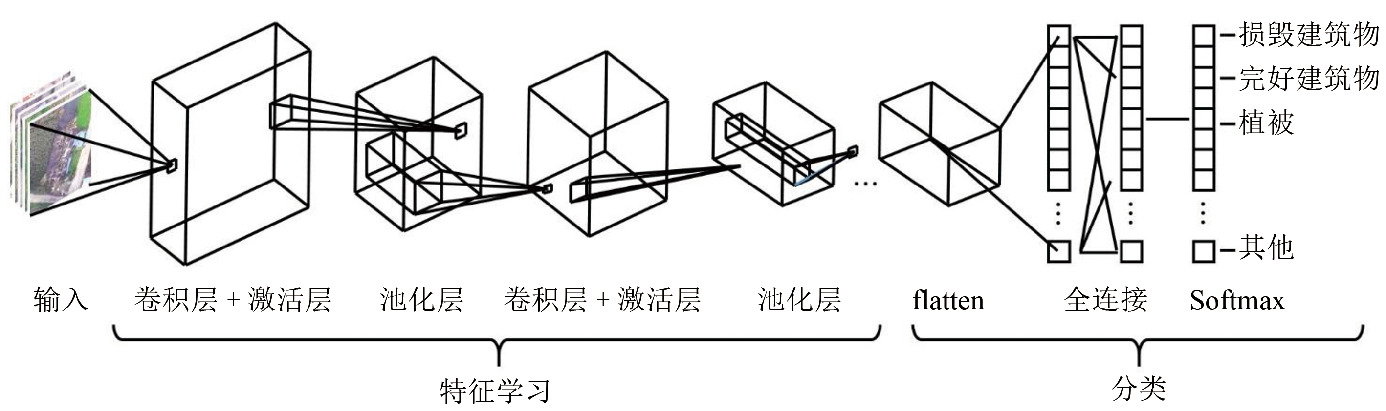
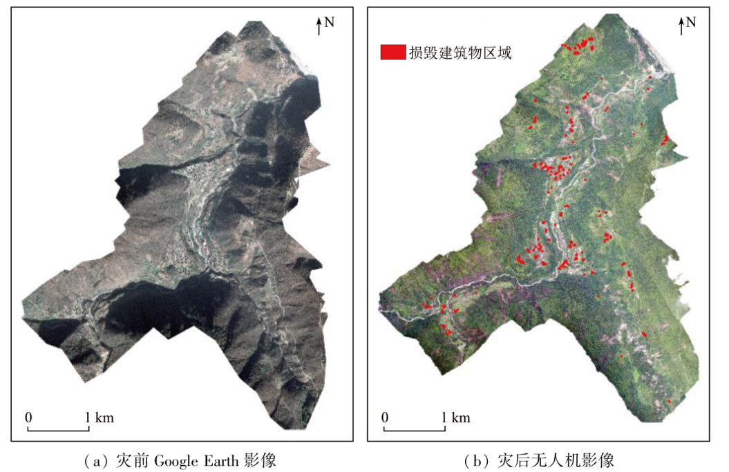
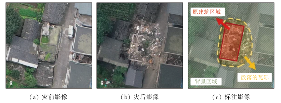
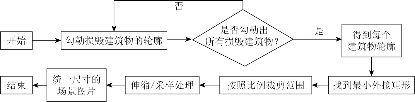
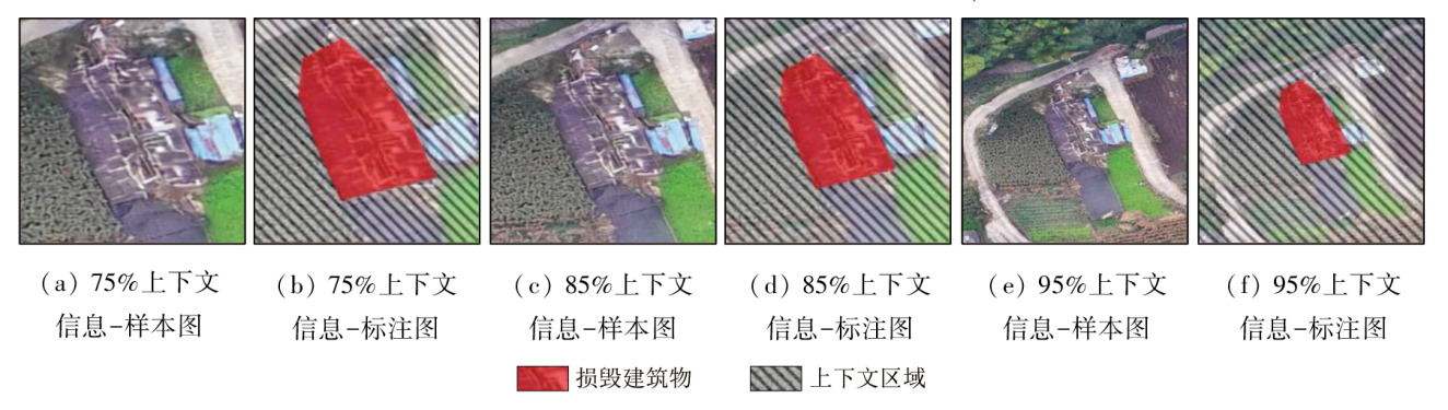
Abstract Deep learning-based scene analysis of remote sensing images serves as a critical means for post-earthquake damage assessment. Given scarce images of damaged buildings, constructing high-quality sample sets of remote sensing scene images holds crucial significance for improving the accuracy of scene recognition and classification. The proportion of contextual information in scene images, as a significant reference for remote sensing analysis, is a key factor affecting the construction effects of sample sets. Currently, the appropriate proportion of contextual information remains under-studied in the sample set construction method. Aiming to construct high-quality sample sets, this study designed a method for adjusting the proportion of contextual information in scene images. It investigated the impacts of different proportions of contextual information on the construction of scene sample sets, exploring the optimal proportion range of contextual information. This study constructed six sample sets of scene images under different proportions of contextual information for training and testing in five classic convolutional neural network (CNN) models. It analyzed the classification results of all the CNN models under different proportions of contextual information. The results indicate that with the proportion of contextual information being 80%, the classification accuracy of the CNN reached an optimal value of 92.22%, which decreased to 89.03% with the proportion of contextual information at 95%. Among all the CNN models, GoogLeNet exhibited superior classification performance with an average accuracy of 93.13%. This study enables the setting of proper proportion ranges of contextual information in scene sample sets, thus effectively improving the classification accuracy of remote sensing scene images, and guiding the construction of sample sets of remote sensing scene images for damaged buildings.
|
| Keywords
scene analysis of remote sensing images
post-earthquake damage assessment
proportion of contextual information
sample set construction of scene images
damaged building
|
|
|
|
Issue Date: 03 September 2024
|
|
|
| [1] |
董静. 应急部发布2022年全国自然灾害基本情况[EB/OL]. 中国日报中文网, 2023(2023-01-13) [2023-03-08]. https://cn.chinadaily.com.cn/a/202301/13/WS63c14826a3102 ada8b22b340.html.
url: https://cn.chinadaily.com.cn/a/202301/13/WS63c14826a3102 ada8b22b340.html
|
| [1] |
Dong J. Ministry of Emergency Management released the basic information of natural disasters across the country in 2022[EB/OL].(2023-01-13) [2023-03-08]. https://cn.chinadaily.com.cn/a/202301/13/WS63c14826a3102ada8b22b340.html.
url: https://cn.chinadaily.com.cn/a/202301/13/WS63c14826a3102ada8b22b340.html
|
| [2] |
眭海刚, 刘超贤, 黄立洪, 等. 遥感技术在震后建筑物损毁检测中的应用[J]. 武汉大学学报(信息科学版), 2019, 44(7):1008-1019.
|
| [2] |
Sui H G, Liu C X, Huang L H, et al. Application of remote sensing technology in earthquake-induced building damage detection[J]. Geomatics and Information Science of Wuhan University, 2019, 44(7):1008-1019.
|
| [3] |
Shafique A, Cao G, Khan Z, et al. Deep learning-based change detection in remote sensing images:A review[J]. Remote Sensing, 2022, 14(4):871.
|
| [4] |
Li Y, Zhang Y, Zhu Z. Error-tolerant deep learning for remote sensing image scene classification[J]. IEEE Transactions on Cybernetics, 2021, 51(4):1756-1768.
|
| [5] |
Yu X, Wu X, Luo C, et al. Deep learning in remote sensing scene classification:A data augmentation enhanced convolutional neural network framework[J]. GIScience & Remote Sensing, 2017, 54(5):741-758.
|
| [6] |
冯权泷, 陈泊安, 李国庆, 等. 遥感影像样本数据集研究综述[J]. 遥感学报, 2022, 26(4):589-605.
|
| [6] |
Feng Q L, Chen B A, Li G Q, et al. A review for sample datasets of remote sensing imagery[J]. National Remote Sensing Bulletin, 2022, 26(4):589-605.
|
| [7] |
Yang Y, Newsam S. Bag-of-visual-words and spatial extensions for land-use classification[C]// Proceedings of the 18th SIGSPATIAL International Conference on Advances in Geographic Information Systems.ACM, 2010: 270-279.
|
| [8] |
Weber E, Kané H. Building disaster damage assessment in satellite imagery with multi-temporal fusion[J/OL]. arXiv, 2020(2020-04-12). http://arxiv.org/abs/2004.05525v1.
url: http://arxiv.org/abs/2004.05525v1
|
| [9] |
Xie Y, Feng D, Chen H, et al. Damaged building detection from post-earthquake remote sensing imagery considering heterogeneity characteristics[J]. IEEE Transactions on Geoscience and Remote Sensing, 2022, 60:4708417.
|
| [10] |
Chen S A, Escay A, Haberland C, et al. Benchmark dataset for automatic damaged building detection from post-hurricane remotely sensed imagery[J/OL]. arXiv, 2018(2018-12-13). http://arxiv.org/abs/1812.05581v1.
url: http://arxiv.org/abs/1812.05581v1
|
| [11] |
Gupta R, Goodman B, Patel N, et al. Creating xBD:A dataset for assessing building damage from satellite imagery[C]// Proceedings of the IEEE/CVF Conference on Computer Vision and Pattern Recognition Workshops.IEEE, 2019:10-17.
|
| [12] |
员娇娇, 胡永利, 孙艳丰, 等. 基于深度学习的小目标检测方法综述[J]. 北京工业大学学报, 2021, 47(3):293-302.
|
| [12] |
Yuan J J, Hu Y L, Sun Y F, et al. Survey of small object detection methods based on deep learning[J]. Journal of Beijing University of Technology, 2021, 47(3):293-302.
|
| [13] |
邓磊, 李海芳. 基于多尺度整体嵌套池化语义的装甲目标检测[J]. 激光与红外, 2022, 52(2):295-304.
|
| [13] |
Deng L, Li H F. An improve multi-scale holistically-nested pooling semantics for object detection[J]. Laser & Infrared, 2022, 52(2):295-304.
|
| [14] |
张路, 廖明生. 一种顾及上下文的遥感影像模糊聚类[J]. 遥感学报, 2006, 10(1):58-65.
|
| [14] |
Zhang L, Liao M S. Contextual fuzzy clustering of remote sensing imagery[J]. Journal of Remote Sensing, 2006, 10(1):58-65.
|
| [15] |
陈丁, 万刚, 李科. 多层特征与上下文信息相结合的光学遥感影像目标检测[J]. 测绘学报, 2019, 48(10):1275-1284.
doi: 10.11947/j.AGCS.2019.20180431
|
| [15] |
Chen D, Wan G, Li K. Object detection in optical remote sensing images based on combination of multi-layer feature and context information[J]. Acta Geodaetica et Cartographica Sinica, 2019, 48(10):1275-1284.
doi: 10.11947/j.AGCS.2019.20180431
|
| [16] |
Wang C, Qiu X, Huan H, et al. Earthquake-damaged buildings detection in very high-resolution remote sensing images based on object context and boundary enhanced loss[J]. Remote Sensing, 2021, 13(16):3119.
|
| [17] |
Zhang J, Xie C, Xu X, et al. A contextual bidirectional enhancement method for remote sensing image object detection[J]. IEEE Journal of Selected Topics in Applied Earth Observations and Remote Sensing, 2020, 13:4518-4531.
|
| [18] |
LeCun Y, Boser B, Denker J S, et al. Backpropagation applied to handwritten zip code recognition[J]. Neural Computation, 1989, 1(4):541-551.
|
| [19] |
四川泸定6.8级地震导致房屋道路等基础设施受损严重[EB/OL]. 京报网, 2022(2022-09-06) [2023-03-08]. https://news.bjd.com.cn/2022/09/06/10148564.shtml.
url: https://news.bjd.com.cn/2022/09/06/10148564.shtml
|
| [19] |
The 6.8-magnitude earthquake in Luding,Sichuan caused serious damage to houses,roads and other infrastructure[EB/OL]. Beijing Daily, 2022(2022-09-06) [2023-03-08]. https://news.bjd.com.cn/2022/09/06/10148564.shtml.
url: https://news.bjd.com.cn/2022/09/06/10148564.shtml
|
| [20] |
四川泸定6.8级地震已造成93人遇难、25人失联[EB/OL]. 新浪财经头条网, 2022(2022-09-12) [2023-03-08]. https://cj.sina.com.cn/articles/view/5182171545/134e1a99902001eqoe.
url: https://cj.sina.com.cn/articles/view/5182171545/134e1a99902001eqoe
|
| [20] |
The 6.8-magnitude earthquake in Luding,Sichuan has caused 93 deaths and 25 missing[EB/OL]. Sina Finance Headline, 2022(2022-09-12) [2023-03-08]. https://cj.sina.com.cn/articles/view/5182171545/134e1a99902001eqoe.
url: https://cj.sina.com.cn/articles/view/5182171545/134e1a99902001eqoe
|
|
Viewed |
|
|
|
Full text
|
|
|
|
|
Abstract
|
|
|
|
|
Cited |
|
|
|
|
| |
Shared |
|
|
|
|
| |
Discussed |
|
|
|
|
 2024,
Vol. 36
2024,
Vol. 36
 ), SHEN Li1(