

0 引言
地质调查经历着由易到难、由浅入深的过程。随着大部分地质条件较好、调查难度较小的区域已具备丰富的调查成果,将调查工作转向地质条件复杂且传统地面工作难以进行的地区已迫在眉睫。遥感技术可以在不与地物直接接触的情况下识别其类别及物理化学性质,是研究地球表层系统的有力工具,也成为地质调查、矿产勘查等工作中不可或缺的技术手段[1]。
目前,适用于地质应用的遥感技术繁多,根据传感器特点可分为光学遥感和微波遥感,其中光学遥感又可根据光谱分辨率细分为多光谱和高光谱遥感。Landsat系列作为多光谱传感器的代表,经过40余a的发展已得到广泛应用。Hyperion,HyMap,CASI和SASI等高光谱传感器凭借极为精细的光谱分辨率,在矿物识别和地质填图等领域展现出了突出的优势[2]。然而光学遥感受太阳辐射和天气的制约明显,难以在夜晚和云雨雪天气对地成像,大大限制了其地质应用范围[3]。合成孔径雷达(synthetic aperture Radar,SAR)作为一种主动式遥感系统,通过发射电磁波并接收其后向散射回波完成成像,能不依赖太阳辐射,全天时对地观测。此外,SAR对云雨雪的穿透作用使得其同时具备全天候的数据获取能力,这也使其成为了一种重要且极具潜力的遥感地质应用数据源,并且在非洲北部、我国内蒙古等沙漠地区以及巴西、马来西亚等热带雨林地区的地质调查中发挥了巨大作用,发现了众多被砂层、植被覆盖的古河道、断裂、岩墙、基岩和火山口等隐伏地质要素[4]。
目前国内虽然已有大量介绍地质体微波散射机理这一雷达地质应用理论基础的相关成果,但对其具体应用情况,特别是国外应用实例的总结研究明显不足。本文以地质体微波散射机理为理论基础,简要总结了SAR在地质考古、岩性识别、地质构造探测和矿产勘查等应用中的国内外研究进展; 介绍了多源遥感数据融合在雷达地质应用中的相关技术方法和应用实例,并结合笔者项目实例对其重要作用进行了分析; 最后,总结了限制雷达遥感技术在国内地质调查中广泛应用的因素,并对后续发展进行了展望。
1.1 地质体微波散射特性
地质体后向散射系数主要取决于地表形态特征以及地表物质复介电常数等[7]。地表形态特征可从宏观和微观尺度进行衡量。宏观尺度的地表形态特征表现为地貌单元组合的变化,其高低受地形高度、形态、坡度和地形组合等直接控制[8]; 微观尺度的地表形态特征常表示为地表粗糙度,是一个以入射波波长为度量单位的相对概念。地表粗糙度决定微波的反射类型,由波长和入射角共同控制。地表粗糙度的判定最早是以瑞利准则为依据,当不规则地表高差(h)大于入射波长(λ)除以8倍入射角(θ)的余弦值时认为其属于粗糙地表。McCauley等[9]对其进一步修改,提出当h>λ/4.4cosθ时,认定为粗糙表面; 当h<λ/25cosθ时,认定为光滑表面。微波与光滑表面发生镜面反射,导致后向散射信号微弱; 与粗糙表面发生漫反射,此时微波向不同方向无规则反射; 当地表粗糙度介于二者之间时,2种反射同时存在[10]。地表粗糙度在雷达影像上具体表征为粗糙度越大,影像相应区域色调越亮。
微波与地质体之间存在3种基本散射过程,分别为奇次散射、偶次散射和体散射[11]。地质体表面为光滑表面时发生奇次散射,雷达天线无法接收到后向散射回波; 地表存在垂直二面角结构时,发生偶次散射,微波沿原路径返回接收天线,表现为强烈的后向散射; 微波穿透目标地物时,由于某些地物内部的不均匀性,导致微波发生体散射。
除地表形态特征以外,地表物质的复介电常数对雷达回波强度也影响很大。复介电常数主要由物质类型、结构和含水量等物理化学性质决定,当地质体表面含水量较高时,主要受含水量控制。含水量越高,复介电常数越高,后向散射系数越大,在影像上越明亮[12]。
此外,影响地质体后向散射系数的因素众多,同种物质在不同的风化条件下可具有不同的后向散射系数,而不同物质也可能相似。因此,利用雷达遥感技术进行地质应用时需要结合研究区地表物质类型、地形地貌特征和风化环境等进行综合分析[13]。
1.2 雷达穿透成像特性
微波能够穿透一定厚度的干燥松散物,为探测隐伏地质要素提供了一种高效的方式,而隐伏地质要素与其他地物间散射类型不同是能被雷达识别的必要条件。
SAR对隐伏地质要素的探测能力受覆盖层物质性质、隐伏地质要素的后向散射系数和雷达系统参数共同决定[9]。覆盖层物质粒径大小和含水量高低是影响雷达信号损耗的重要因素,决定着微波的穿透深度[14]。研究表明,粒径大于入射波长的1/5或者含水量高于1%时,微波穿透能力会被大大减弱[15,16]。雷达系统参数如微波入射角、波长和极化方式等,也决定着雷达对隐伏地质要素的增强能力[17,18]。SAR对隐伏地质要素的增强作用得益于微波在穿透覆盖层时发生的折射现象,使到达隐伏地质要素表面的微波入射角和波长均发生缩减。其中,入射角减小导致入射横截面增大,波长减小使得隐伏地质要素粗糙度增加,均能增强隐伏地质要素的后向散射强度。不同极化方式雷达影像对不同隐伏地质要素的表征能力也存在差异,需针对不同研究区和研究对象具体分析[17]。
20世纪70年代以来,多颗SAR传感器的升空运行为雷达地质应用提供了数据支持,其中的明星产品有SEASAT-A和SIR系列等,然而这些传感器均已结束服役,目前在轨和即将发射的SAR传感器拥有更先进的参数,具体如表1所示。
表1 目前在轨和准备发射的SAR传感器及其相关参数
Tab.1
| 传感器 | 国家或地区 | 波段 | 发射 时间 | 设计 寿命/a | 重访 周期/d | |||||
|---|---|---|---|---|---|---|---|---|---|---|
| Radarsat-2 | 加拿大 | C波段 | 2007年 | 7 | 24 | |||||
| TerraSAR-X | 德国 | X波段 | 2007年 | 5 | 11 | |||||
| COSMO-SkyMed | 意大利 | X波段 | 2007年 | 5 | 16 | |||||
| Risat-1 | 印度 | C波段 | 2012年 | 5 | 25 | |||||
| HJ-1 C | 中国 | S波段 | 2012年 | 3 | 31 | |||||
| KOMPSAT-5 | 韩国 | X波段 | 2013年 | 5 | 28 | |||||
| ALOS-2 | 日本 | L波段 | 2014年 | 5 | 14 | |||||
| Sentinel-1 | 欧洲 | C波段 | 2014年 | 7 | 12 | |||||
| GF-3 | 中国 | C波段 | 2016年 | 8 | —① | |||||
| 传感器 | 国家 | 波段 | 发射 时间 | 设计 寿命/a | 重访 周期/d | |||||
| SAOCOM | 阿根廷 | L波段 | 2018年(预计) | 5 | 16 | |||||
| CSG-1 | 意大利 | X波段 | 2018年(预计) | 8 | 16 | |||||
| Obzor-RN1 | 俄罗斯 | X波段 | 2019年(预计) | 7 | 2 | |||||
| BIOMASS | 欧洲 | P波段 | 2020年(预计) | 5 | — | |||||
| TanDEM-L | 德国 | L波段 | 2022年(预计) | 12 | 16 | |||||
| SCLP | 美国 | Ku和 X波段 | 2030年(预计) | 4 | 15 | |||||
①表示未知。
2 雷达遥感地质应用
2.1 地质考古
雷达的穿透成像能力使其成为热带雨林和沙漠地区文化遗产观测的重要遥感数据来源[19],已经被广泛应用到地质考古领域,尤其是古河道的分布研究中。
Adams等[20]最初意识到SAR在地质考古中的应用潜力,通过分析伯利兹和危地马拉蒂卡尔地区L波段机载雷达影像,发现了被植被覆盖的流域面积超过12 000 km2的古河道,并根据流域面积和古人口规模间的关系,推测出玛雅低地是当时中美洲地区农耕密度最高的古文明; McCauley等[9]在埃及西部撒哈拉沙漠地区SIR-A影像上也发现了类似的古河道和古人类活动遗址,该地区气候干燥,砂层粒径和厚度均较适宜被作为典型研究区,广泛用于SAR穿透能力的研究[21,22]; 通过对该区大量雷达影像的研究,共发现古遗迹1处、古水系900余km、隐伏双环形火山口1个及类火山口结构1 300余个[23,24]; 苏丹博尔戈尔山地区的库施王国遗址古墓地金字塔在一定几何条件下形成雷达二面角反射,在ALOS PALSAR和Radarsat-2这2种影像上均表现出强烈的散射回波[25]; 伊拉克萨迈拉古城的古城墙雷达反射情况与之类似,但受ALOS PALSAR空间分辨率制约,部分古河道只在Radarsat-2影像上有所表征[26]; Freeman等[27]利用柬埔寨吴哥古城的AirSAR影像,通过识别古河道和池塘堤坝等古水系要素对高棉帝国的古景观和分布范围进行了推测,并在古城周围植被茂密地区首次发现了直线型人工水系等要素; Linck等[28]在叙利亚古罗马要塞地区TerraSAR-X影像上发现了兵营、仓库和古墙壁等遗址,在探地雷达数据的辅助下证明了在该类干燥无植被覆盖地区,X波段雷达数据凭借其高空间分辨率不仅能很好地探测地面遗迹,还能凭借微弱的穿透能力(25 cm)对浅覆盖下遗迹内部结构进行辨别。
国内早在20世纪90年代就已开展雷达考古研究。郭华东[29]和Lu等[30]利用航天飞机飞行方向与古长城平行的SIR-C影像,通过古长城角反射器结构所导致的强散射回波,识别出了宁夏—陕西交界处被干沙覆盖的3道明、隋代古长城。探测古河道不仅对古遗迹、古人类活动研究意义重大,还对认识区域古环境演化过程有所帮助。Guo等[31]在内蒙古阿拉善高原地区发现,沙粒在风力搬运作用下容易在古河道形成的负地形处累积,且不同时期古河床含水量差异在雷达影像上反映为色调差异,据此在Radarsat和SIR系列雷达影像上发现一条自西南向东北流向的古河道,并通过古今地势差异及该地区断裂和古湖泊的分布特征,认为该区域地势变化由新构造运动控制。
2.2 岩性识别
雷达岩性识别的基础是在同一风化环境中,含水量高低基本相似的情况下,不同性质岩石具有不同的物理化学性质,使得其抗风化能力有所差异,形成的风化物颗粒大小、节理方向均有所区别,导致不同的地表粗糙度,在雷达影像上表现为色调差异。
火山地区不同期次熔岩常形成不同粗糙度的地表,在雷达岩性识别研究中得到了关注。Mackenzie等[32]在冰岛阿斯恰火山地区SEASAT影像上通过色调差异识别出了9种地表单元类型,并完成了野外验证; Dierking等[33]不仅利用EMISAR交叉极化影像对冰岛北部火山地区块状和绳状熔岩进行了识别,还通过水平和垂直极化间的相位差对同种熔岩表面不同植被覆盖情况也进行了区分; Murino等[34]发现意大利南部火山地区不同期次熔岩的植被覆盖情况有所差异,通过修正Cloude极化分解特征对不同植被覆盖的区分能力,识别了该地区不同期次熔岩和火山碎屑岩,并进一步识别出石灰岩、石灰白云岩、层状沙质土壤、砾岩、凝灰岩和冲积层等; Guo等[35]通过不同类型熔岩、基岩和冲积层在SIR-C/X-SAR不同波段和极化方式雷达影像上的表征差异,发现在昆仑山阿克赛钦湖东北部火山群地区L波段交叉极化影像岩性识别效果最好。除火山作用外,冰川作用也常引起地表粗糙度的明显差异。Dall等[36]在格陵兰岛EMISAR机载全极化影像上通过更明亮的色调,从辉长岩中识别出了片麻岩。赵福岳等[8]在新疆大黑山通过不同地表单元在雷达影像上的色调纹理特征建立解译标志,完成了研究区内区域地质填图和地层、岩体识别等工作; 倪卓娅[37]在黄山地区也进行了相关工作,研究发现在特定地区通过建立灰度-结构单元进行的雷达地质填图,识别结果甚至优于多光谱影像。
2.3 地质构造探测
除自动提取以外,利用雷达不同波段和极化方式假彩色合成影像进行目视解译也是雷达地质构造解译的主要方法。SIR-C/X-SAR因同时具有L,C和X 3个波段,并且在L和C波段具备4种极化方式,利用该传感器数据构建的假彩色合成影像既能利用不同波段影像空间分辨率差异,又能利用不同地表类型的极化信息差异,是雷达地质构造目视解译的有利数据源。Abdelsalam等[40]利用该数据在苏丹东北部新元古代缝合带新发现超过300 km的基岩构造,并分析出该缝合带构造演化受左旋走滑断裂和逆冲构造共同影响,这一新发现使得该缝合带成为非洲东北部最长的基底构造之一; Guo等[41]利用该方法在广东肇庆地区发现了植被覆盖下的1个逆冲断层和6个线性构造。极化分解合成不仅能提高全极化SAR岩性分类精度,而且不同物理散射类型波段组合也对地质构造探测有积极的作用。代晶晶[42]在非洲埃塞俄比亚西部地区的ALOS PALSAR和Radarsat-2全极化数据极化分解假彩色合成影像上,识别出了一条剪切带,解译出的断裂主要呈NW—SE向、NNW—SSE向和近SN向展布,与该地区地质调查情况一致。
2.4 矿产勘查
矿产资源遥感勘查主要通过利用遥感技术对成矿地质背景、地质条件和地质形迹等与成矿地质作用相关的成矿、控矿和示矿信息进行提取和识别[1]。雷达能够穿透地表植被和干燥松散覆盖层识别隐伏控矿构造,在覆盖区遥感地质找矿中具有突出优势。张满郎等[43]在中等植被覆盖度的河北金厂峪金矿地区TM和JERS-1影像上发现了3条成矿构造带,总结出该地区的3种金矿成因类型,对该地区找矿工作具有很好指导意义; 在植被覆盖度更高的马来西亚地区,Pour等[44]利用ALOS PALSAR单极化影像对沙捞越州的巴乌金矿地质构造进行了识别,发现该地区地质断裂受4期构造作用控制,其中图班断裂和泰巴力断裂带中的SSW—NNE向构造与金矿矿化密切相关; Kusky等[45]在埃及东南部沙漠阿拉伯—努比亚地盾地区,利用C和L波段SIR-C/X-SAR水平极化以及L波段垂直极化的假彩色合成影像,结合TM影像波段比值假彩色合成结果,发现该地盾矿床受4期构造运动控制,其中第2期构造产生的角闪岩和蓝片岩相与硫化物沉积及石英脉型金矿密切相关,硫化铜区带和其他的石英脉型金矿受第3期构造产生的EW向褶皱和剪切带控制,第4期构造活动产生的沿断层分布岩墙群与浸染次生铀、稀土富集相关。
3 多源数据融合技术在雷达遥感地质中的应用
不同传感器影像特性差异明显,在遥感地质应用中充分利用不同传感器的优势很有必要。雷达独特的穿透成像能力以及突出的纹理结构信息有利于探测隐伏地质构造,而光学遥感丰富的光谱信息有利于识别地物类型。对多光谱影像和雷达影像进行融合,不仅能提高不同地质要素的识别能力,更能对之间的嵌套关系进行梳理,通过重建区域性地层和构造历史,为区域构造演化分析提供更多依据。
多源数据融合方法分为像素级、特征级和决策级3个层级。相比特征级和决策级融合,像素级融合尽可能多地保持了影像的原始信息,能够为地质解译提供更多的细节信息,在遥感地质调查中得到了广泛应用,其主要方法有波段比值、HIS变换和主成分分析(principal component analysis,PCA)变换等[46,47]。HIS变换是将多光谱影像中3个独立或组合波段进行假彩色合成,并变换至HIS色彩空间中,利用SAR强度数据替换亮度(I)分量并通过逆变换完成融合。经过HIS变换融合后的影像不仅能利用光谱信息对与地质单元相关的不同岩相组分进行区分,还能通过地表粗糙度对地形地貌、地表风化状态及沉积序列等进行分析[48]。张满郎等[43]利用该方法将JERS-1雷达影像和TM影像进行了融合,通过融合影像上岩性和构造等信息,结合成矿背景知识划分了河北金厂峪金矿地区成矿构造带及金矿成因类型,取得了较好的应用效果; 颜蕊[49]在鄂尔多斯盆地评价了不同传感器雷达影像和TM影像不同波段组合方式间的HIS融合效果,发现Envisat水平极化影像与TM B7(R),B4(G),B1(B)假彩色合成影像融合效果最好,并在融合影像上发现该地区NW向和NNW向共轭交错的2大断层,其中NW向断层将一个大环形构造分割为2个小环形构造,再结合地形地貌和地层岩性等信息,最终圈定出该地区2个潜在矿源区,为该地区矿产调查提供了新的线索。
除多光谱影像外,航空物探数据和DEM也常被作为遥感地质应用中影像融合的数据源。航空物探主要探测物理场信息,包括磁数据、重力数据和放射性数据等,其中放射性数据主要包括铀、钍、钾和总计数等[50]。DEM将遥感影像的表达从二维空间提升到三维空间中,能增强显示构造地貌等信息[51]。Paradella等[50]在巴西卡拉加斯地区利用HIS变换对雷达数据、Landsat TM数据和多种航空物探数据进行了融合,发现SAR与放射性总计数融合影像能明显反映地形和岩体单元基岩放射性,SAR与放射性铀或钍数据融合影像能增强对岩性差异和热液交代作用的识别,为热带雨林植被覆盖典型区域遥感矿产调查提供了思路; Teruiya等[51]根据该方法对卡拉加斯地区SAREX和航空物探数据进行了融合,利用融合影像研究了NNE向脆性构造的增强作用,确定该地区受脆性构造影响的围岩金铜矿化主要来源是深层岩体的花岗岩热液迁移。
融合影像不仅具有丰富的地表形态信息,同时对地植物光谱异常反映也十分敏感,通过岩性与地植物异常间的相互关系可识别不同岩性。Thurmond等[52]利用HIS变换将埃塞俄比亚阿尔法凹陷Radarsat-1雷达数据与ASTER和ETM+假彩色波段合成影像进行融合,并叠加到DEM影像上进行三维显示,在融合影像上不仅能区分玄武岩熔岩流和较新的中性熔岩流,还能对该凹陷内陡坡断层面等与地形显著相关的地质构造进行识别,而这些构造受干燥环境和凹陷发育等限制很少存在物质搬移,单纯利用雷达影像难以识别。
笔者在参与“天山—北山重要成矿区带遥感调查”项目的过程中,为充分利用雷达影像的空间纹理信息和多光谱影像的岩性光谱信息,利用PCA变换将ALOS-2 PALSAR-2雷达数据和Landsat8 OLI B7(R),B5(G),B2(B)假彩色合成影像进行了融合。其中,ALOS-2 PALSAR-2数据选用其高视角四极化模式产品,经过多视、辐射定标、地形校正、地理编码和滤波等预处理后,空间分辨率重采样为6 m。
融合影像具备较高的空间分辨率和丰富的纹理信息,同时还拥有丰富的岩性色调信息,不仅能通过遥感影像上的线性特征识别地质构造信息,而且能通过线性要素两侧岩性差异对地层错动进行识别,从而达到探测地质构造的目的。断裂构造融合结果如图1所示。
图1
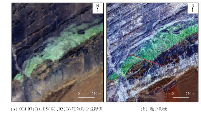
图1
断裂构造光学影像和融合影像对比
Fig.1
Comparison of fractal structures on optical and fused images
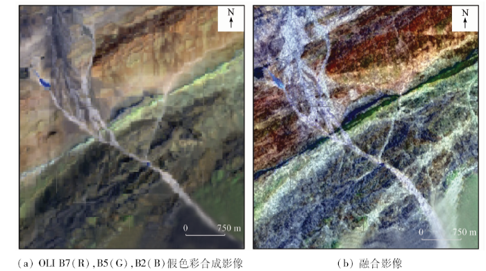
影像融合技术还直接提高了光学影像的空间分辨率,不仅有利于探测地质构造,还提升了不同岩性界线间的可区分程度。
研究区内一条受区域断裂控制的NE向岩脉如图2所示。
图2
4 结论与展望
合成孔径雷达作为重要的遥感数据源,已在热带雨林和内陆沙漠地区的地质矿产调查中发挥出了巨大的作用,其主要原因有以下3点: ①雷达主动发射电磁波并接收地物后向散射回波,能全天时、全天候对地观测,为低纬度多云雨地区提供稳定的遥感地质应用数据来源; ②雷达对特定方向线性构造的增强能力和不同地表粗糙度差异敏感特性使得其在地质构造探测和岩性识别方面具有独到的优势; ③雷达能穿透一定厚度的植被和砂层,可实现对光学影像和地面调查不可见的隐伏地质要素的探测。
但目前雷达遥感地质应用依然存在较多问题,其主要原因可概括为过高的使用成本,具体表现为: ①雷达影像自身存在叠掩、透视收缩以及斑点噪声等问题,在预处理之前影像效果不甚直观,理解起来较为困难; ②极化SAR影像处理平台,如PolSARpro和SARScape等,在交互逻辑和用户界面上相比光学影像处理平台均存在较大差距; ③雷达数据大多需要订购且费用较为昂贵,进一步增加了使用成本。
上述种种限制因素随着软硬件技术的发展正逐渐减弱,如今越来越多遥感地质人员已经认识到雷达技术的优势并开展应用研究,雷达影像处理平台也更加强大、友好、智能。部分传感器也开始提供免费且质量稳定可靠的影像数据。这将使我国雷达遥感技术地质应用水平得到进一步提升。
志谢: 在地质解译过程中有幸得到四川省地质调查院尹显科、裴亚伦等专家的大力帮助,在论文撰写过程中得到了课题组陈吉科博士、李二珠博士、谢相见博士、罗洁琼博士和戴晨曦硕士的诸多指导和宝贵意见,在此表示感谢。
参考文献
遥感地质勘查技术与应用研究
[J].遥感的发展极大地拓宽了人类的视野和视觉能力,以其宏观性、综合性、多尺度、多层次的特点,已成为地质研究和地质勘查不可缺少的技术手段,在地质调查、矿产勘查、地质环境评价、地质灾害监测和基础地质研究等方面都发挥了越来越大的作用。随着传感器分辨率(空间、光谱、时间、辐射)的不断提高,特别是高光谱和干涉雷达技术的发展,不仅极大地提高了遥感的观测尺度、对地物的分辨本领和识别的精细程度,而且使遥感地质发生了由宏观探测到微观探测,由定性解译到定量反演的质的飞跃,将遥感地质和应用都推向一个新的高度。本文首先简要介绍了遥感技术的发展及其意义,遥感地质找矿的原理、方法和遥感找矿模型,然后分别从岩矿波谱、遥感图像处理、多光谱蚀变异常提取、高光谱矿物识别与填图、InSAR地表形变调查与监测、遥感找矿模型、遥感地质灾害调查与监测7个方面介绍了遥感的基本原理、主要的技术方法、技术特点和技术关键、主要的应用领域,以及取得的一些研究成果和应用实例。
Remote sensing technology and its application in geological exploration
[J].
高光谱遥感卫星技术及其地质应用
[J].
DOI:10.3969/j.issn.1671-2552.2009.02.020
URL
[本文引用: 1]

在收集国内外高光谱技术发展、地质应用与研究实例资料的基础上,主要介绍了国内外高光谱地质应用的现状及其主要进展,并简要介绍了高光谱地质应用的主要技术.结合地质应用成功的实例.分析了高光谱遥感卫星技术在矿物识别与填图、岩性填图、矿产资源勘探、矿业环境监测、油气渗漏监测等地学方面的应用优势与前景,同时指出了目前高光谱遥感卫星技术地质应用存在的主要问题与发展趋势.
The hyperspectral remote sensing technology and its application
[J].
热红外遥感岩矿信息提取研究进展
[J].
DOI:10.3321/j.issn:1001-8166.2005.10.011
URL
[本文引用: 1]
热红外遥感是岩矿遥感信息领域起步未久,且表现出巨大潜力的技术手段.从岩矿发射率光谱、数据处理及信息提取技术方法、应用研究3个方面对热红外遥感在岩矿信息提取中的研究现状进行了全面总结,在此基础上对其发展难点及趋势进行了讨论,并对其在地质领域的应用前景进行了评估.在数据获取方面,高光谱分辨率数据是应用要求与发展趋势;数据处理方面,对大气影响进行定量评价并力求高精度的大气校正方法是难点与不可回避的问题,大气是影响数据质量的最大因素.岩矿热红外遥感信息机理(矿物发射率光谱特征与机理、光谱混合行为、光谱变异因素)的定性研究取得了一定进展,定量化的研究是发展趋势;在地质领域,因为可以对矿物种类(包括不含水矿物)及含量进行高精度提取的突出优势,不仅在矿产勘探,而且在基础地质研究方面将发挥巨大作用.
Progresses in minerals information extraction using thermal remote sensing
[J].
雷达遥感的地质学应用及其进展
[J].<p>合成孔径雷达(SAR)遥感以其独有的全天时、全天候观测能力和对地表的穿透性及形态探测能力,特别是现在新型成像雷达技术的发展,使之在地质学应用中具有独特的优势。结合SAR应用技术的发展阶段,即由单波段单极化到多波段多极化,再发展到现在极化测量和干涉测量阶段,综述了成像雷达遥感在地学中的应用,特别是对新型成像雷达技术(极化雷达、干涉雷达)的地学应用作了介绍。</p>
Geology application of Radar remote sensing technology and its development
[J].
合成孔径雷达(SAR)在地质、灾害应用研究中的新进展
[J].<p>针对地质应用的需求,从SAR成像原理及发展现状,阐述了雷达在地质中的应用前景,总结了SAR方法在地质研究、地质灾害监测中的应用和特点,结合近年来国内外研究人员的最新研究成果,总结了SAR在地面目标的识别与分类、InSAR在地质遥感中对地面形变、地震及地质灾害监测中的优势和特点、地质研究与应用中常用的SAR处理方法.通过合理利用雷达数据,不断改进算法和模型,就能获得更加丰富的地质、地物的表象,为地质研究提供新的信息,克服人们难以达到或者由于客观条件而造成的地区数据缺乏的困难.</p>
The new progress of synthetic aperture Radar(SAR)in geological and disaster researching
[J].
侧视雷达成象因素及其地质应用
[J].
Imaging factors of side-view Radar and its geological application
[J].
SAR遥感数据用于岩性识别与分类的研究
[J].利用新疆北部山区雷达遥感数据,通过遥感数字图像处理与增强,生成雷达遥感假彩色合成影像应用于岩性判释。对不同岩性岩石,利用极化雷达提供的地表岩石的多种散射信息作为输入进行计算机神经网络分类,岩性识别分类的总精度为62.6%。与常规雷达数据分类对比,分类精度与岩石识别正确率均有显著提高。
Application of SAR remote sensing data to lithological identification and rock classification
[J].
合成孔径雷达图像填图方法与应用探讨
[J].<p>以ERS-2和RadarSat-1卫星雷达数据为信息源,通过新疆1∶25万大黑山幅遥感地质填图研究,从方法与应用角度分析论述了雷达图像的地质反映,总结出回波强度与地形单元和岩石之间变化规律、宏观粗糙度对回波强度的控制以及灰度-结构单元作为填图基本单位的方法技术和填图含义。</p>
Geological mapping method based on synthetic-aperture Radar image and its application
[J].
Subsurface valleys and geoarcheology of the eastern Sahara revealed by shuttle Radar
[J].
DOI:10.1126/science.218.4576.1004
URL
PMID:17790589
[本文引用: 3]
The shuttle imaging radar (SIR-A) carried on the space shuttle Columbia in November 1981 penetrated the extremely dry Selima Sand Sheet, dunes, and drift sand of the eastern Sahara, revealing previously unknown buried valleys, geologic structures, and possible Stone Age occupation sites. Radar responses from bedrock and gravel surfaces beneath windblown sand several centimeters to possibly meters thick delineate sand- and alluvium-filled valleys, some nearly as wide as the Nile Valley and perhaps as old as middle Tertiary. The now-vanished major river systems that carved these large valleys probably accomplished most of the erosional stripping of this extraordinarily flat, hyperarid region. Underfit and incised dry wadis, many superimposed on the large valleys, represent erosion by intermittent running water, probably during Quaternary pluvials. Stone Age artifacts associated with soils in the alluvium suggest that areas near the wadis may have been sites of early human occupation. The presence of old drainage networks beneath the sand sheet provides a geologic explanation for the locations of many playas and present-day oases which have been centers of episodic human habitation. Radar penetration of dry sand and soils varies with the wavelength of the incident signals (24 centimeters for the SIR-A system), incidence angle, and the electrical properties of the materials, which are largely determined by moisture content. The calculated depth of radar penetration of dry sand and granules, based on laboratory measurements of the electrical properties of samples from the Selima Sand Sheet, is at least 5 meters. Recent (September 1982) field studies in Egypt verified SIR-A signal penetration depths of at least 1 meter in the Selima Sand Sheet and in drift sand and 2 or more meters in sand dunes.
地表浅层不同介质覆盖区雷达图像信息构成要素分析
[J].
Detect and recognition of the composing factor of Radar image information in shallow covered geological body and fault in arid area
[J].
A three-component scattering model for polarimetric SAR data
[J].
DOI:10.1109/36.673687
URL
[本文引用: 1]
An approach has been developed that involves the fit of a combination of three simple scattering mechanisms to polarimetric SAR observations. The mechanisms are canopy scatter from a cloud of randomly oriented dipoles, evenor double-bounce scatter fr...
成像雷达(SAR)遥感地质应用综述
[J].
DOI:10.6053/j.issn.1001-1412.2003.1. 012
URL
[本文引用: 2]
成像雷达(SAR)遥感以其 独有的全天时、全天候观测能力和对地表的穿透性及形态探测能力,特别是现在新型成像雷达遥感技术的发展,使之在地质学应用中比光学遥感更具优势。文章结合 SAR应用技术的发展过程,即由单波段单极化到多波段多极化,再发展到现在极化测量和干涉测量阶段,综述了成像雷达遥感在地学中的应用,特别对新型成像雷 达技术(极化雷达、差分干涉雷达)在岩性分类、探测地震区域形变的地学应用作了实例介绍。
Geological application of Radar remote sensing technology and its development
[J].
极化雷达目标分解方法用于岩性分类
[J].
DOI:10.3321/j.issn:1007-4619.2000.03.011
URL
Magsci
[本文引用: 1]
雷达遥感中地表不同岩石类别的后向散射一般差别不大, 因此以散射幅度为主要探测因子的常规雷达遥感数据不利于岩性分类。极化雷达以散射矩阵或Stokes矩阵的形式, 记录了更多的地物回波信息。信息源的增多, 有利于提高岩性分类的精度。但是, 由于不同极化状态回波信号之间的相关性, 极化数据不可避免地产生数据冗余, 反而增大了岩性分类的误差。为增强极化数据在岩性分类中的应用, 使用Colude提出的目标相关矩阵特征向量分解方法, 将岩石散射分成互相独立的 3部分:单向散射, 双向散射和交叉散射。目标分解技术降低了同一岩性岩石同极化回波之间的相关性, 更清晰地显示了不同岩石类别的散射强度差异, 显示了极化数据在岩性分类中的优势。利用1994年 10月获取的新疆北部山区SIR C极化数据, 对不同岩性岩石的目标分解数据以及线性极化后向散射强度数据进行了综合的统计分析, 建立了适合每一种岩性识别的散点图, 并将这些数据作为输入端进行神经网络分类, 分类精度最大可达 94%, 误差最小为 1.06 %。
Lithological classification of polarimetric SAR data with target decomposition method
[J].
Detection of subsurface features in SEASAT Radar images of Means Valley,Mojave Desert,California
[J].
DOI:10.1130/0091-7613(1984)122.0.CO;2
URL
[本文引用: 1]
Igneous dikes buried beneath as much as 2 m of alluvium in the Mojave Desert of California were detected by the SEASAT L-band (23.5-cm wavelength) synthetic-aperture radar (SAR) in 1978. The roughness and dihedral configuration of the dikes are favorable to generation of strong radar echos. The soil-moisture levels in 1978 were likely below the critical 1% level. The other permissive conditions for radar penetration of a fine-grained and thin alluvial cover are present. Our findings suggest that subsurface features with potential tectonic or geomorphic significance may be revealed in other orbital radar images of semiarid terrains.
Dielectric properties of soils at UHF and microwave frequencies
[J].
DOI:10.1029/JB079i011p01699
URL
[本文引用: 1]
The complex dielectric constant of four soils, including a sand, a silt, and two clays, was measured over the frequency range from 0.1 0103 109 Hz to 26 0103 109 Hz. The water content of the soils was varied from 0.0 g H2O/g soil to 0.15 g H2O/g soil, and the temperature from 2400°C to 2000°C. The dielectric relaxation spectrum of water in soils was found to be displaced to lower frequencies than the dielectric relaxation spectrum of water in bulk. The results showed that the relation between volumetric water content and the complex dielectric constant is relatively independent of soil type. At temperatures above freezing the complex dielectric constant of water in soils, at the water contents investigated, decreases with temperature, a type of behavior normally found only in solids. Below the freezing point the phase composition of water in soils determines the temperature dependence of the complex dielectric constant.
Coherent electromagnetic losses by scattering from volume inhomogeneities
[J].
DOI:10.1109/TAP.1975.1141170
URL
[本文引用: 1]
A parametric analysis of the coherent electromagnetic losses due to scattering from volume weak inhomogeneities is reported. It is shown that even in the case of very weak inhomogeneities, the loss could be appreciable in a resonance region and thus play a more dominant role than conductivity losses.
Spaceborne Radar subsurface imaging in hyperarid regions
[J].
DOI:10.1109/TGRS.1984.350641
URL
[本文引用: 2]
Imaging data acquired with the Shuttle Imaging Radar (SIR-A) over the hyperarid region of Egypt/Sudan clearly show surface penetration through the sand cover. Even though absorption does occur in the sand layer, surface refraction leads to a steeper incidence angle at the sand/bedrock interface resulting in a stronger backscatter. A simple backscatter model shows that for a low-loss thin sand layer the presence of the covering layer enhances the capability to image the subsurface interface, particularly at large incidence angles and HH polarization.
SIR-B subsurface imaging of a sand-buried landscape:Al Labbah Plateau, Saudi Arabia
[J].
DOI:10.1109/TGRS.1986.289676
URL
[本文引用: 1]
Despite a diminution in the transmit and receive power of the SIR-B system, a striking L-band radar image was produced for a portion of the southern Al Labbah Plateau, Saudi Arabia, a landscape dominated by eolian sand features. Distinct tonal and digital number (DN) signatures uniquely define 1) areas where the SIR-B beam penetrated a relatively thin sand sheet to be diffusely reflected from the buried carbonate rocks of the Aruma Formation and 2) a thick sand hill and associative sand shadow where SIR-B subsurface imaging did not occur. Computer analysis of the digital SIR-B image data indicates there is about a 26-DN difference between the sand-buried Aruma Formation and the unpenetrated sand hill and shadow. Depth measurements from more than 80 test holes show that subsurface imaging occurred through a sand layer whose maximum measured thickness is 1.24 m. The penetrated medium is a fine-to medium-grained low-density quartz sand that had a very low moisture content (average of about 0.2 weight percent) on the day of the Space Shuttle overpass. The minimum thickness of sand features where subsurface imaging did not occur is thought to be about 3.1 m.
雷达遥感考古机理、应用与展望
[J].
DOI:10.11873/j.issn.1004-0323.2015.5.0835
URL
Magsci
[本文引用: 1]
<p>面对雷达遥感多模式、多极化和高分辨率等发展趋势,结合考古学对空间技术的迫切需求,从雷达遥感工作特性出发,阐述了雷达遥感考古的机理。在回顾雷达遥感考古取得成就的基础上,围绕考古目标探测与发现、监测与诊断等现实需求,提出了一种适应于考古研究的雷达遥感实施框架;并对当前所面临的科学问题及研究内容进行了深入探索与分析。应用实践认为以项目实施为牵引,建立典型示范案例地,开展雷达遥感机理、方法与模型等考古适应性研究刻不容缓,并可着实推进我国文明探源与遗产地可持续化发展。</p>
Principle,application and prospects of synthetic aperture Radar (SAR) remote sensing in archaeology
[J].
Radar mapping,archeology,and ancient Maya land use
[J].
DOI:10.1126/science.213.4515.1457
URL
PMID:17780866
[本文引用: 1]
Abstract A severe incongruity has long existed between the well-known complexity of ancient Maya civilization and the relatively feeble economic base that could be reconstructed for it. Recent fieldwork has ihdicated that much more intensive cultivation patterns were used than was previously thought. Data from the use of synthetic aperture radar in aerial surveys of the southern Maya lowlands suggest that large areas were drained by ancient canals that may have been used for intensive cultivation. Ground checks in several limited areas have confirmed the existence of canals, and excavations and ground surveys have provided valuable comparative information. Taken together, the new data suggest that Late Class period Maya civilization was firmly grounded in large-scale and intensive cultivation of swampy zones.
The use of multifrequency and polarimetric SIR-C/X-SAR data in geologic studies of Bir Safsaf,Egypt
[J].
DOI:10.1016/S0034-4257(96)00143-5
URL
[本文引用: 1]
Bir Safsaf, within the hyperarid core of the Sahara in the Western Desert of Egypt, was recognized following the SIR-A and SIR-B missions in the 1980s as one of the key localities in northeast Africa, where penetration of dry sand by radar signals delineates previously unknown, sand-buried paleodrainage valleys (radar-rivers) of middle Tertiary to Quaternary age. The Bir Safsaf area was targeted as a focal point for further research in sand penetration and geologic mapping using the multifrequency and polarimetric SIR-C/X-SAR sensors. Analysis of the SIR-C/X-SAR data from Bir Safsaf provides important new information on the roles of multiple SAR frequency and polarimetry in portraying specific types of geologic units, materials, and structures mostly hidden from view on the ground and on Landsat TM images by a relatively thin, but extensive blanket of blow sand. Basement rock units (granitoids and gneisses) and the fractures associated with them at Bir Safsaf are shown here for the first time to be clearly delineated using C- and L-band SAR images. The detectability of most geologic features is dependent primarily on radar frequency, as shown for wind erosion patterns in bedrock at X-band (3 cm wavelength ), and for geologic units and sand and clay-filled fractures in weathered crystalline basement rocks at C-band (6 cm) and L-band (24 cm). By contrast, Quaternary paleodrainage channels are detectable at all three radar frequencies owing, among other things, to an usually thin cover of blow sand. The SIR-C/X-SAR data investigated to (late enable us to make specific recommendations about the utility of certain radar sensor configurations for geologic and paleoenvironmental reconnaissance in desert regions.
Subsurface imaging in south-central Egypt using low-frequency radar:Bir Safsaf revisited
[J].
DOI:10.1109/TGRS.2003.813275
URL
[本文引用: 1]
We present the capabilities of low-frequency radar systems to sound the subsurface for a site located in south-central Egypt, the Bir Safsaf region. This site was already intensively studied since the SIR-A and SIR-B orbital radars revealed buried paleodrainage channels. Our approach is based on the coupling between two complementary radar techniques: the orbital synthetic aperture radar (SAR) in C and L bands (5.3 and 1.25 GHz) for imaging large-scale subsurface structures, and the ground-penetrating radar (GPR) at 500 and 900 MHz for sounding the soil at a local scale. We show that the total backscattered power computed from L-band SAR and 900-MHz GPR profiles can be correlated, and we combined both data to derive the geological structure of the subsurface. GPR data provide information on the geometry of the buried scatterers and layers, while the analysis of polarimetric SAR data provides information on the distribution of rocks in the sedimentary layers and at the interface between these layers. The analysis of 500-MHz GPR data revealed some deeper structures that should be detected by lower frequency SARs, such as a P-band system.
Mapping subsurface geology in sahara using L-band SAR:First results from the ALOS/PALSAR imaging Radar
[J].
DOI:10.1109/JSTARS.2010.2056915
URL
[本文引用: 1]
Within the framework of Kyoto & Carbon Initiative of the Japanese Space Agency (JAXA), we used JERS-1 and ALOS/PALSAR radar images to build regional and continental scale mosaics of Sahara. The unique capability of L-band SAR to map subsurface structures in arid areas revealed previously unknown geological features: craters, faults, paleo-rivers. The latter are of particular interest for water resource detection in arid regions.
Near-surface imaging of a buried foundation in the Western Desert,Egypt,using space-borne and ground penetrating Radar
[J].
DOI:10.1016/j.jas.2012.12.019
URL
[本文引用: 1]
ALOS/PALSAR L-band full polarimetric data have been used to detect and characterize a well-defined geometric target hidden under sand deposits in the Western Desert of Egypt. This buried object is rectangular in shape with very straight boundaries and encloses an area of 500 m2. Inside the rectangular area there is a perfectly circular feature of approximately 53 m2 area. High and medium resolution optical satellite images (WorldView-2, ALOS/AVNIR-2) and field investigation confirm that the topography of the study area is relatively flat and completely covered by dry sand. The electromagnetic wave scattering behavior of the detected buried object was measured by decomposing the scattering matrix of ALOS/ PALSAR full polarimetric data into Entropy-Alpha (H/a) and Freeman and Durden decompositions. Furthermore, a combination of unsupervised classification algorithms and Constant False-Alarm Rate (CFAR) edge detection was performed on the polarimetric data which revealed a well-defined geometric shape with straight borders. These borders have high a angles with low entropy, which physically means double bounce scattering mechanism with low randomness and is very similar to that of an urban scatterer, indicating that the detected target might be a buried wall-like foundation of a man-made structure. Moreover, 28 ground penetrating radar (GPR) profiles were acquired using a 270 MHz shielded antenna to validate the satellite radar remote sensing results. The GPR profiles reveal very clear hyperbolic shapes at 1.5 m depth with one of them showing a large hyperbolic shape-like structure, which might indicate the presence of a buried foundation. Thus the site might have significance to archaeological studies of the Western Desert, particularly previous human occupation and the sources of water for such habitation. (C) 2012 Elsevier Ltd. All rights reserved.
Polarimetric multifrequency and multi-incidence SAR sensors analysis for archaeological purposes
[J].
DOI:10.1002/arp.1448
URL
[本文引用: 1]
The aim of the present work was to compare Advanced Land Observing Satellite (ALOS) Phased Array type L-band Synthetic Aperture Radar (PALSAR) with RADARSAT-2 C-band satellite in order to identify the most suitable method for the detection of ground anomalies due to the presence of shallow underground archaeological structures. This comparison was performed over two UNESCO archaeological sites: Djebel Barkal (northern province of Meroe, Sudan) and Samarra (13065km north of Bagdad, Iraq). The choice of these two cultural sites was motivated by their position in a desert area (especially the Djebel Barkal site) where soil moisture has smaller impact on radar wave penetration, thus not compromising data interpretation. The largest difference between the satellites is the spatial resolution, around 2065m for the PALSAR sensor and 965m for the RADARSAT-2 satellite. Given the importance of spatial resolution for archaeological purposes, that difference is balanced by the wave band utilized, which can be translated in differences in soil penetration. However, the quite superficial remains in both the sites give different but complementary responses. Polarimetric SAR data were analysed with PolSARpro software, and all the products were then compared with archaeological maps and available optical satellite images, used as a basis for the georeferencing process. This work constitutes a fundamental step in archaeological research toward a correct interpretation of all the scattering mechanisms above or around ancient structures. Additional information, such as meteorological conditions where available and archaeological maps (that can be consulted from the UNESCO website), was used as a support for interpretation of the archaeological areas; in the case of the Iraqi city of Samarra and of the archaeological area of Gebel Barkal, ground-truth surveys in situ are not allowed for political reasons. Copyright 08 2013 John Wiley & Sons, Ltd.
New research in polarimetric SAR technique for archaeological purposes using ALOS PALSAR data
[J].
DOI:10.1002/arp.1446
URL
[本文引用: 1]
The work presented here is a further study of the UNESCO Cultural Heritage sites of Samarra (Iraq) and Djebel Barkal archaeological area (Sudan) by means of polarimetric products of the Japanese satellite ALOS PALSAR. Despite the Iraqi war ending in 2011, the city of Samarra is still included on the UNESCO List of Sites in Danger (since 2007). The study of the city presented here began three years ago with the analysis of optical data. The work showed an urban and agricultural expansion affecting the integrity of the city. An attempt to study Samarra by using the polarimetric SAR technique was made in previous years with the employment of the ALOS PALSAR satellite. That study was limited to the analysis of polarimetric descriptors such as entropy and alpha angle, parameters that gave results regarding prevalence of double-bounce and volume scattering mechanisms in the area investigated. The second archaeological site, Djebel Barkal, is one of five archaeological sites located in a semi-desert area along the River Nile, in the Napatan Region considered to be part of Nubia. The site was included in the UNESCO World Heritage List in 2003. Polarimetric descriptors considered in previous studies of the zone were entropy and alpha angle. Also in this case, a deeper analysis was carried out with the addition of a second ALOS PALSAR polarimetric SAR image, acquired 3 years later. In the present work, more polarimetric parameters, such as Freeman and Yamaguchi decompositions, are taken into account in order to observe scattering mechanisms both upon the structures already known and the area around them. Thanks to these decompositions and the archaeological maps that were available, it was possible to validate backscattered responses in ALOS PALSAR images as archaeological structures. Copyright 2013 John Wiley & Sons, Ltd.
Analysis of Radar images of Angkor,Cambodia
Possibilities of archaeological prospection by high-resolution X-band satellite Radar-a case study from Syria
[J].
DOI:10.1002/arp.1444
URL
[本文引用: 1]
The launch of the first German radar satellite TerraSAR-X in 2007 opened a new era in spaceborne radar remote sensing. So far the applicability for the high-resolution prospection of upstanding and, especially, buried monuments was limited because of the low resolution of the former sensors. TerraSAR-X, however, provides us with images with a spatial resolution of up to 1m. The satellite operates in the so-called X-band with a frequency of 9.65GHz. Therefore it is supposed that there is no possibility to penetrate the soil with this sensor. To testify and analyse the benefit of TerraSAR-X in archaeological geophysics, we chose as a test site a Roman fortress in Syria. The site was chosen as we already have GPR data of the same area for a comparison and for the verification of the actual penetration depth. Our results revealed that it is possible to resolve superficial and even buried structures in the data set, which provides evidence that the X-band waves can penetrate the soil. This paper shows our results of the survey and an estimation of the possible penetration depth of TerraSAR-X. Copyright (c) 2013 John Wiley & Sons, Ltd.
航天多波段全极化干涉雷达的地物探测
[J].
DOI:10.11834/jrs.19970105
URL
Magsci
[本文引用: 1]
航天飞机成象雷达3号及X波段合成孔径雷达(SIR-C/X-SAR)计划是一项包括中国在内有13个国家合作进行的大型雷达对地观测研究计划。SIR-C/X-SAR具有L、C、X3个波段及L、C波段HH,HV,VH,VV极化,X波段VV极化同时成象的能力,可获得全极化及干涉雷达数据,是本世纪内最先进的航天成象雷达系统。该文系统介绍了SIR-C/X-SAR中国项目开展以来取得的研究成果。重点阐述了中国雷达试验区及与SIR-C/X-SAR成象飞行同步开展的航天-航空-地面立体同步观测试验和对干沙的穿透性试验,以及在相关领域和不同地区的应用,包括昆仑山火山群的发现,广东肇庆植被覆盖区地质体的识别,明、隋两代长城的探测与极化响应分析,海洋及城市特征研究。
Spaceborne multifrequency,polarametric and interferometric Radar for detection of the targets on earth surface and subsurface
[J].
Detection of the Great Wall using SIR-C data in North-Western China
Subsurface old drainage detection and paleoenvironment analysis using spaceborne Radar images in Alxa Plateau
[J].
DOI:10.1007/BF02959455
URL
[本文引用: 1]
For geological and environmental research in an arid area, a unique advantage of radar remote sensing is that radar wave can penetrate a certain layer of dry sand (a few centimeters to meters thick) to reach the buried bedrock. The penetration capability is able to reveal the subsur-face geological structure and old drainage paths. Based on the analysis of SIR-A, SIR-B, SIR-C, Radarsat ScanSAR, Landsat MSS and Landsat TM images acquired on different dates and the investigations made in several field trips in Alxa Plateau of Inner Mongolia, a number of old river valley and lake basins buried by wind-blown sand were recognized. Two parallel old drainage systems in the north and middle of the study area are delineated. The study suggests that the moving sand belts mainly follow the old drainage courses. This study also establishes a preliminary drain-age evolution model for an area of about 300 000 km 2 since the Tertiary, and finds that the Alxa Plateau was once an area with many rivers and lakes with a warm and humid climate. The relief reversion caused by neotectonic movement since “Qinghai-Tibet movement” is also analyzed.
Use of SEASAT SAR imagery for geological mapping in a volcanic terrain:Askja Caldera, Iceland
[J].
DOI:10.1080/01431168608954675
URL
[本文引用: 1]
Nine distinct surface types have been identified by comparison of SEASAT SAR imagery with field observations in the Askja Caldera region of central Iceland. A map of radargeological surface type is presented, together with field descriptions and discussion of the influence of the surface types on radar signal return. Surface relief, surface roughness and clast size were found to have the greatest importance for imageinterpretation.
L-band polarimetric SAR-signatures of lava flows in the Northern Volcanic Zone,Iceland
Using SIR-C/X-SAR data in the analysis of volcanic and sedimentary areas.The Campania test site (Southern Italy)
Use of multifrequency,multipolarization shuttle imaging Radar for volcano mapping in the Kunlun Mountains of Western China
[J].
DOI:10.1016/S0034-4257(96)00175-7
URL
[本文引用: 1]
A group of volcanoes northeast of Aksayqin Lake, in the western Kunlun Mountains, China, have been identified on multifrequency, multipolarization spaceborne imaging radar-C/X-band synthetic aperture radar (SIR-C/X-SAR) images. Field observations made on the volcanic morphology and terrain features are described in this paper. Analysis of single-band, single-polarization radar backscatter coefficients (σ°) shows that LHV best discriminates the two types of lava flows (pahoehoe and aa lavas), alluvium, and bedrock. The factors affecting the radar backscatter coefficient also are analyzed. Finally, this paper presents KAr isotopic ages of volcanic samples collected in the field and discusses the volcanism in the area.
Geologic mapping in Greenland with polarimetric SAR
基于SAR影像的岩性分类及其在地质上的应用研究
[D].
Research on Lithological Classification Using SAR Image and Its Application on Geology
[D].
Lineament extraction from Landsat TM,JERS-1 SAR,and DEM for geological applications
Analysis of the segments extracted by automated lineament detection
Mapping Precambrian structures in the Sahara Desert with SIR-C/X-SAR Radar:The Neoproterozoic Keraf Suture,NE Sudan
[J].
DOI:10.1029/96JE01391
URL
[本文引用: 1]
A major N-trending Neoproterozoic suture between composite arc terranes of the Arabian-Nubian Shield in the east and older crust of the Nile Craton to the west is inferred to trend N-S close to the Nile in northern Sudan. We used shuttle imaging radar (SIR) C/X synthetic aperture radar (SAR) imagery to find and map these structures in the poorly known Keraf Suture which are not apparent on visible or near IR imagery due to extensive sand cover. L band (23 cm wavelength) radar images best resolve geologic structure; the other frequencies of the SIR-C/X-SAR system (X and C bands) permit qualitative evaluation of the effects of surface versus subsurface backscattering. Interpretation of L band images supported by field work indicates that the Keraf Suture is 50 km wide and >550 km long, making it the longest basement structure recognized to date in NE Africa. The northern part of the Suture comprises ophiolitic rocks which were thrust westward over tightly folded sediments of the Nile Craton. The southern Keraf Suture is dominated by N- and NNW-trending, left-lateral strike-slip faults that affect previously deformed passive margin sediments. Associated with these faults are NE-trending transpressional folds and a possible transtensional basin. These structures are interpreted to be due to NW-SE oblique collision between the Arabian-Nubian Shield and the Nile Craton, as east and west Gondwana collided in the last 150 m.y. of Neoproterozoic time.
Detection of structural and lithological features underneath a vegetation canopy using SIR-C/X-SAR data in Zhao Qing test site of southern China
[J].
DOI:10.1029/96JE01974
URL
[本文引用: 1]
In a subtropical region, the application of remote sensing in geological survey and mapping is limited by the dense vegetation and soil cover and poor data availability due to clouds and rain. This study emphasizes the detection of structural and lithological features underneath a vegetation canopy using shuttle imaging radar C/X band synthetic aperture radar (SIR-C/X-SAR) data. Zhao Qing test site in southern China was selected for this study. The SIR-C/X-SAR data have advantages including all weather, all time imaging capability, high altitude, and wide swath along with the expanded information from multifrequency and multipolarization that improves the geological interpretibility, especially in a moist, vegetated region. This paper presents interpretations of structures, beds, and lithostratigraphic units from the shuttle imaging radar data, and makes an assessment of SIR-C/X-SAR data for geological mapping.
PALSAR及RADARSAT2全极化雷达数据在地质构造应用中的研究
[J].由于雷达数据不受天气影响,且具有一定的穿透能力,近年来已被广泛的运用在地质构造信息提取研究中。ALOS PALSAR与RADARSAT2是近年发展的最先进的雷达传感器,其全极化模式同时又具有较高的空间分辨率,这为植被区地质构造研究提供了良好的数据源。本文选取非洲埃塞俄比亚西部为研究区,通过对研究区域两种全极化雷达数据进行正射校正、极化合成等处理,对比分析了其在地质构造应用中的优劣,结果表明PALSAR全极化数据较为有利;最后选取PALSAR全极化数据,结合区域地质背景,提取了研究区的构造信息,提取结果与区域整体构造格架一致。
Application of PALSAR and RADARSAT2 quad-polar data to study of geological structure
[J].
Landsat TM及JERS-1 SAR数据在金矿探测中的应用研究
[J].
DOI:10.1007/BF02951625
URL
[本文引用: 2]
金矿遥感探测之关键在于成矿构 造及铁氧化物、含羟基蚀变矿物的信息提取。JERS—1SAR在构造探测方面具有很大的优势,可通过噪斑消除及边缘增强的空间滤波来提取构造信息。 LandsatTM可通过主成分变换,比值分析-主成分变换来提取蚀变矿物波谱信息、抑制植被波谱干扰。这两种遥感数据的复合处理可综合蚀变与构造信息。
Application of Landsat TM and JERS-1 SAR data to gold exploration
[J].
Structural geology mapping using PALSAR data in the Bau gold mining district, Sarawak,Malaysia
[J].
DOI:10.1016/j.asr.2014.02.012
URL
[本文引用: 1]
The application of optical remote sensing data for geological mapping is difficult in the tropical environment. The persistent cloud coverage, dominated vegetation in the landscape and limited bedrock exposures are constraints imposed by the tropical climate. Structural geology investigations that are searching for epithermal or polymetallic vein-type ore deposits can be developed using Synthetic Aperture Radar (SAR) remote sensing data in tropical/sub-tropical regions. The Bau gold mining district in the State of Sarawak, East Malaysia, on the island of Borneo has been selected for this study. The Bau is a gold field similar to Carlin style gold deposits, but gold mineralization at Bau is much more structurally controlled. Geological analyses coupled with the Phased Array type L-band Synthetic Aperture Radar (PALSAR) remote sensing data were used to detect structural elements associated with gold mineralization. The PALSAR data were used to perform lithological-structural mapping of mineralized zones in the study area and surrounding terrain. Structural elements were detected along the SSW to NNE trend of the Tuban fault zone and Tai Parit fault that corresponds to the areas of occurrence of the gold mineralization in the Bau Limestone. Most of quartz-gold bearing veins occur in high-angle faults, fractures and joints within massive units of the Bau Limestone. The results show that four deformation events (D1 4) in the structures of the Bau district and structurally controlled gold mineralization indicators, including faults, joints and fractures are detectable using PALSAR data at both regional and district scales. The approach used in this study can be more broadly applicable to provide preliminary information for exploration potentially interesting areas of epithermal or polymetallic vein-type mineralization using the PALSAR data in the tropical/sub-tropical regions.
Structural controls on Neoproterozoic mineralization in the South Eastern Desert,Egypt:An integrated field,Landsat TM,and SIR-C/X SAR approach
[J].
DOI:10.1016/S0899-5362(02)00029-5
URL
[本文引用: 1]
The Arabian–Nubian Shield represents a complex amalgam of arcs and microcontinents assembled during Neoproterozoic closure of the Mozambique Ocean. The 750–720 Ma Allaqi suture is an arc/arc collision zone, formed when the Gerf terrane in the north overrode the circa 830–720 Ma Gabgaba terrane in the south, prior to closure of the Mozambique Ocean. Neoproterozoic rocks include ophiolitic ultramafic–mafic rocks, metasediments, intermediate metavolcanic rocks, intrusive gabbro-diorite rocks, granodiorites, biotite granites, and leucocratic granites. High-pressure/low-temperature metamorphism has been documented in rocks of the suture zone. Mineral deposits include nickel–copper–platinum and podiform chromite in ultramafic rocks, marble, gold-bearing quartz-veins in D 2 and D 3 shear zones, and radioactive mineralization associated with late leucocratic granitic rocks. Integrated field mapping and remote sensing techniques are used to distinguish and map the relationships between rock units, structures, and alteration zones associated with mineral deposits along the Allaqi suture of Egypt's SE Desert. Landsat TM images processed using a band ratioing technique show different rock types remarkably well, and are able to distinguish between alteration zones associated with ultramafic rocks (listwaenites) and those associated with leucocratic granitic rocks (greisenization, silicification and albitization). Black and white L-band SIR-C/X SAR images outline foliations, faults and folds that control mineralization at several deposits in the area, whereas color composite multiband Chh-Lhh-Lhv SIR-C/X SAR images reveal some elliptical granitic bodies that host radioactive mineralization. E-trending, tight to isoclinal, gently dipping folds, thrust faults and subvertical shear zones related to the Allaqi suture are overprinted by N-oriented structures related to the Wadi Ungate shear zone, formed during collision of east and west Gondwana during closure of the Mozambique Ocean. The location of the Wadi Ungate shear zone in the Wadi Shellman area was previously unknown due to burial of basement rocks beneath thin dry sands. A new structural map was prepared using Landsat TM ratio images and SIR-C/X SAR imagery. SIR-C/X SAR data conveys considerably more information about rocks and structures beneath the thin sand cover than discernible from aerial photographs or Landsat TM images.
遥感数据融合方法分析与评价综述
[J].
DOI:10.3969/j.issn.1000-3177.2003.03.015
URL
[本文引用: 1]
论述了几种常用的基于像元级遥感影像融合方法的原理、特点、作用及限制条件 ,对各种相应的算法进行了分析和评价 ,归纳并阐明了遥感数据融合效果定量评价指标及其意义 ,展望了遥感数据融合方法的发展与应用前景
Analysis and evaluation of method on remote sensing data fusion
[J].
SAR影像与TM影像的几种融合处理方法
[J].利用彩色空间变换、比值变换及相关系数法分别对SAR影像与TM3 、TM4 、TM5 三波段影像进行融合处理。文章介绍了影像融合中的具体技术问题及其处理方法。因侧视雷达图像一般有明显的孤立噪声,所以,在进行影像融合处理之前,先对SAR影像进行预处理,文中用δ滤波法抑制孤立噪声(光斑) .最后,从视觉效果、熵、平均梯度值以及标准差等4 方面评价了影像融合的质量。
The fusion approaches for SAR and TM images
[J].
Integration of SIR-C/X-SAR and Landsat TM data for geologic mapping and resource exploration
沉积岩区雷达遥感成矿信息提取方法及应用研究
[D].
Research about the Way of SAR Images for Metallogenic Information Extraction in Sedimentary Petrologic Area and Its Application
[D].
Airborne and spaceborne synthetic aperture Radar (SAR) integration with Landsat TM and gamma ray spectrometry for geological mapping in a tropical rainforest environment,the Carajás Mineral Province,Brazil
[J].DOI:10.1080/014311697218232 URL [本文引用: 2]
Integrating airborne SAR,Landsat TM and airborne geophysics data for improving geological mapping in the Amazon Region:The Cigano Granite,Carajás Province,Brazil
[J].
DOI:10.1080/01431160801891838
URL
[本文引用: 2]
This study examines the value of integrating airborne C‐band Synthetic Aperture Radar (SAR), Landsat Thematic Mapper (TM) and airborne gamma spectroradiometric data with field, petrographic and geochemical data for geological mapping of the Cigano batholith, an important representative of the Paleoproterozoic granitic magmatism in the Carajás Mineral Province (CMP), Amazon region. Distinct schemes for the integration of radar/optical and radar/optical/gamma data were evaluated and the geological information derived from the integrated products was verified in the field. The investigation allowed the re‐evaluation of previous geological information and the definition of distinct domains within the Cigano pluton and country rocks. The importance of brittle structures related to the tectonic evolution of the area and the location of intensely altered zones in the pluton was emphasized, favouring new insights into current geological and exploratory models of the area. The application of a similar approach as operational routine in exploration programmes in the Amazon region is justified considering the limited geological information, the availability of aerogeophysical data and airborne/spaceborne remote sensing data (radar, optical) and the high costs of field mapping in this kind of terrain.
Optical-Radar-DEM remote sensing data integration for geological mapping in the Afar Depression,Ethiopia
[J].
DOI:10.1016/j.jafrearsci.2005.10.006
URL
[本文引用: 1]
The advantages of integrating optical (Landsat Enhanced Thematic Mapper Plus (ETM+) and Advanced Spaceborne Thermal Emission and Reflection Radiometer (ASTER)) and radar (Shuttle Imaging Radar (SIR) – C, X-band Synthetic Aperture Radar (SAR) and RADARSAT-1) remote sensing data, and digital elevation models (DEMs) (Shuttle Radar Topography Mission (SRTM)) for geological mapping in arid regions such as the Afar Depression in Ethiopia are demonstrated. The Afar Depression in NE Africa is a natural laboratory for studying processes of sea-floor spreading and the transition from rifting to true sea-floor spreading. It is ideal for geological remote sensing because of its vastness, remoteness and inaccessibility together with almost continuous exposure, and lack of vegetation and soil cover. Optical-radar-DEM remote sensing data integration is used for: (1) Distinguishing spatial and temporal distribution of individual lava flows in the Quaternary Erta ‘Ale Volcanic Range in the northern part of the Afar Depression, by integrating band-ratios of ASTER thermal infrared (TIR) data with Landsat ETM+ visible and near infrared (VNIR) and SIR-C/X-SAR L-band ( λ 02=022402cm) data with horizontally transmitted and horizontally received (HH) polarization. (2) Visualizing and interpreting extensional imbrication fans that constitute part of the Dobe Graben in the central part of the Afar Depression by integrating Landsat ETM+ VNIR data with RADARSAT C-band ( λ 02=02602cm) data with HH polarization and SRTM DEMs. These imbrication fans were developed as layer-parallel gravitational slip of the border fault hanging-wall towards the graben center. (3) Mapping morphologically defined structures in rhyolite flows exposed on the flanks of the Tendaho Rift by merging ASTER VNIR and short wave infrared (SWIR) with RADARSAT C-band data with HH polarization. The Tendaho Rift constitutes part of the Tendaho-Gobaad Discontinuity that separates the southern and the central eastern parts of the Afar Depression. Optical-radar-DEM data integration proved to be an effective approach for aiding geological mapping and structural analysis in arid regions such as the Afar Depression.
四川省矿山遥感监测主要成果与进展
[J].针对四川省矿产资源分布特征,开展了矿山遥感监测工作,构建了“遥感数据源选取—遥感数字图像处理—遥感信息提取—野外验证—图件制作”相对完整且较为成熟的矿山开发遥感监测技术方法体系。以卫星光学遥感数据为主、航空光学遥感数据和雷达数据为辅,并采用无人机遥感图像;在正射纠正、几何配准、数据融合等图像预处理基础上,结合有关资料建立矿山开采面、矿山建筑、排土场、尾矿库、选矿厂、滑坡和泥石流的遥感解译标志;采取以目视解译为主、计算机自动提取与目视解译相结合、辅以野外验证的方法进行遥感解译;建立以遥感调查数据为主要数据源的矿山地质环境评价指标体系与 GIS 定量评价方法,实现矿山地质环境评价;采用矿山遥感监测与传统地质环境调查技术相结合方法,开展矿山环境综合治理区划研究。取得的成果与进展包括:①首次建立了省域矿产资源开发环境本底数据库,为实现矿山开发环境动态监测和国土资源空间数字化管理提供了基础数据;②监测成果已在矿产卫片执法、矿山环境治理和矿产资源规划等国土资源管理工作中发挥了重要作用,成为了四川省矿政管理的重要参考依据;③开展了矿山遥感监测技术方法研究与探索,形成了适应川西南山区的矿山遥感监测技术方法体系。
Major achievements and progress of remote sensing monitoring mines in Sichuan Province
[J].
