

0 引言
1 视频卫星国内外发展现状
目前,国内外已发射了数颗可进行视频拍摄的低轨小卫星,其发射时间与主要技术指标见表1。2007年印度尼西亚发射了“印度尼西亚国家航空航天研究所-柏林技术大学卫星”(LAPAN-TUBSAT) [6]。2009年南非也发射了与LAPAN-TUBSAT类似的Sumbandliasat视频小卫星[6]。2010年2月11日,NASA发射了太阳动态观测卫星(SDO), 该卫星可每天24小时对太阳观测并拍摄有关太阳的4K超高清全彩视频[7]。Skybox公司于2013年和2014年分别发射了SkySat-1与SkySat-2,这两颗卫星都可拍摄米级分辨率的黑白视频。2014年1月,UrtheCast公司将名为“伊里丝”(Iris)的高分辨率虹膜相机送往“国际空间站”并成功安装,可对地球进行分辨率为1 m的4K超高清全彩(UHD)视频拍摄[8]。2014年2月,萨里卫星技术美国(SSTUS)公司公布了“萨里-V1C”(Surrey-V1C)彩色视频成像卫星产品[3]。在国内,2014年9月由中国国防科技大学研制的试验卫星“天拓二号”发射升空,可拍摄5 m分辨率的黑白视频[9]。2015年10月,中国长光卫星公司发射“吉林一号”,该卫星可拍摄米级分辨率的全彩视频[10]。
| 卫星/平台 | 发射时间 | 国家或机构 | 视频颜色 | 视频分辨率/m | 帧率/(帧/s) | 成像区域/km2 | 视频长度/s |
|---|---|---|---|---|---|---|---|
| LAPAN-TUB SAT | 2007.1 | 印度尼西亚 | 黑白 | 200 | 50 | 81×81 | - |
| Sumbandliasat | 2009.9 | 南非 | 黑白 | - | - | - | - |
| 太阳动态观测卫星 (SDO) | 2010.2 | 美国NASA | 彩色 | - | - | - | 1 800 |
| SkySat-1 | 2013.11 | 美国Skybox | 黑白 | 1.1 | 30 | 2×1.1 | 90 |
| UrtheCast | 2014.1 | 加拿大 | 彩色 | 1.0 | 30 | 5×3.4 | 90 |
| Surrey -V1C | 2014.2 | 美国SSTUS | 彩色 | <1 | 100 | 1 800~3 600 | |
| SkySat-2 | 2014.7 | 美国Skybox | 黑白 | 1.1 | 30 | 2×1.1 | 90 |
| LAPAN-A2 | 2014.9 | 印度尼西亚国家 航空航天研究所 | 黑白 | 200 | 50 | 81×81 | - |
| 天拓二号 | 2014.9 | 中国国防科大 | 黑白 | 5 | 25 | - | 180 |
| 吉林一号 | 2015.10 | 中国长光卫星公司 | 彩色 | 1.13 | 25 | 4.6×3.4 | 90 |
从表1可以得出,目前以国外发射的商业视频小卫星为主,中国商业视频卫星紧跟国外发展; 从影像质量来看,Skybox公司和Urthecast公司发射的视频卫星成像质量较好。Skybox公司发射的SkySat-1和SkySat-2、Urthecast公司的视频卫星和长光卫星公司的“吉林一号”代表了国内外视频卫星发展的前沿水平。下文分别介绍这3个公司发射的视频卫星的参数。
1.1 SkySat-1和SkySat-2卫星
SkySat卫星的主要技术指标见表2[14]。SkySat-1卫星是由Skybox Imaging公司于2013年11月13日发射的民用对地观测卫星,是世界首颗亚米级视频卫星; SkySat-2卫星于2014年7月8日从拜科努尔发射升空[12],该卫星与SkySat-1相比多了肼推进系统,以完成轨道控制[13]。这2颗卫星能在俯仰、滚动和偏航3个方向进行侧摆机动,实现了“凝视”对地观测,互补金属氧化物半导体(Complementary Metal Oxide Semiconducto,CMOS)探测器具有前后左右4个方向的自由度[4],配合平台的3个自由度,实现图像的运动补偿,可以以30帧/s的速率连续捕获90 s的稳定的MP4格式的全高清视频,也具备捕捉最高质量的彩色图像和分辨率优于1 m的可见光和近红外图像的能力。未来Skybox公司将部署24颗小卫星构成的对地观测星座,具备每天8次的重访能力。
| 项目名称 | 主要指标 | |
|---|---|---|
| 轨道 | 太阳同步轨道,轨道高度为578 km(Skysat-1)和629 km(Skysat-2) | |
| 整星质量/kg | 约83 | |
| 尺寸 | 小于60 cm×60 cm×95 cm | |
| 数据 传输 | 天线口径/m | φ2.4 |
| 星下点空间 分辨率/m | 0.9(PAN),2(RGB+NIR) | |
| 幅宽/km | 8 | |
| 文件格式 | 16 bit(有效量化位数16bit) | |
| 视频 模式 | 谱段/nm | 450~900(PAN) |
| 空间分辨 率/m | 1.1 | |
| 视频覆盖 范围 | 2.0 km×1.1 km | |
| 持续时间/s | 90 | |
| 帧频/(帧/s) | 30 | |
| 帧尺寸 | 2 560×1 080像素 | |
| 视频大小 | 1 920 ×1 080像素 | |
| 文件格式 | MPEG-4压缩(H.264) | |
| 视频属性 | 黑白,1080P全高清视频 | |
1.2 UrtheCast卫星
表3 UrtheCast卫星的“Iris”相机主要技术指标
Tab.3
| 项目名称 | 主要指标 | |
|---|---|---|
| 国际空间站轨道 | 360 km | |
| 视频模式 | 空间分辨率/m | 1.0 |
| 视频覆盖范围 | 5.0 km×3.4 km | |
| 持续时间/s | 90 | |
| 帧频/(帧/s) | 3 | |
| 帧尺寸 | 3 024×4 536像素 | |
| 帧速率 | 3.25 fps | |
| 文件格式 | MPEG-4压缩(H.264) | |
| 视频属性 | 彩色,1 080P全高清视频 | |
1.3 吉林一号卫星
表4 “吉林一号”视频星的主要技术指标
Tab.4
| 项目名称 | 主要指标 | |
|---|---|---|
| 轨道 | 近地太阳同步轨道,轨道高度为656 km | |
| 整星质量/kg | 95 | |
| 尺寸 | 小于60 cm×60 cm×95 cm | |
| 卫星转体/(度/秒) | 3 | |
| 侧摆角 | -50°~50° | |
| 数据传输 | 天线口径/m | φ2 |
| 视频模式 | 空间分辨率/m | 1.13 |
| 视频覆盖范围 | 4.6 km×3.4 km | |
| 持续时间/s | 90 | |
| 帧频/(帧/s) | 25 | |
| 帧尺寸 | 2 160×3 840像素 | |
| 视频大小 | 1 920×1 080像素 | |
| 文件格式 | MPEG-4压缩(H.264) | |
| 视频属性 | 贝尔彩色,4K超清视频 | |
目前“吉林一号”已发射4颗卫星,计划到2030年将实现138颗卫星组网,形成全球任意点10 min以内的观测能力,届时有望提供全球最高时间分辨率和空间分辨率的遥感数据 [15]。
2 光学遥感视频卫星成像原理
图1
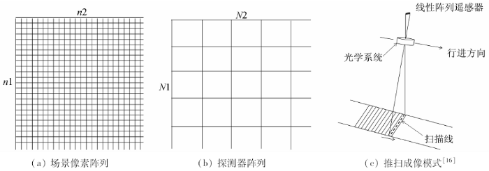
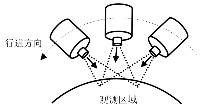
采用视频模式的视频卫星沿着其运动轨迹,可通过卫星姿态的快速调整,实现侧摆角度范围内的成像,控制光学遥感器盯住地球上的某一目标区域,利用面阵探测器对其进行连续高帧频凝视成像观测[6],同时实现了高空间分辨率和高时间分辨率成像,如图2所示。由于视频卫星使用的是面阵传感器,为了保证其光学遥感器的光轴始终对准地面目标区域,卫星姿态控制系统需要实时调整卫星的姿态。理论上低轨卫星平台的敏捷调整能力需要达到卫星运行速度的1%以上,才可以克服卫星的轨道运动、姿态运动和地球自转带来的目标区域不断偏离光轴的影响[18]。通过以下相机内方位参数可以确定成像时刻遥感器的的视线方向: 全框幅面阵在焦平面上的安排、像主点在焦平面上的坐标、各彩色面阵的主距、各彩色面阵的光学畸变系数、机械臂在载体平台上的方位、相机的姿态及其精度、相机光心的位置及其精度、卫星转体的姿态及其精度等[5]。
图2
低轨敏捷卫星的视频成像模式的优势在于可以利用卫星姿态的机动调整,在一定程度上解决大幅宽与高分辨率的矛盾,成像执行能力得以提高,从而在真正意义上实现了高时间分辨率和高空间分辨率。视频模式的缺点在于卫星观测角度一直在变化,其拍摄的视频无法进行几何校准与几何定位; 另外,视频卫星是通过牺牲观测的空间范围来换取高时间分辨率的。
3 视频卫星应用展望
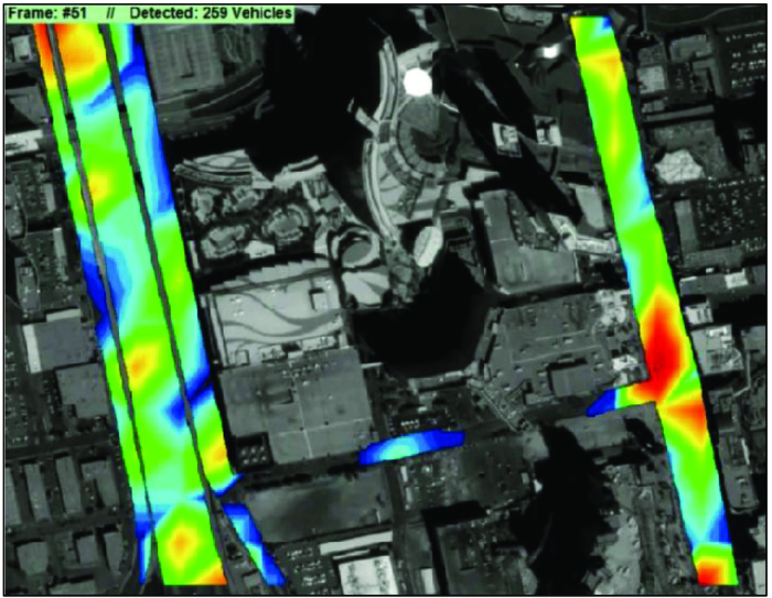
视频卫星的出现实现了时间分辨率的大幅提升,能够持续观测地表动态变化。目前国内外学者在该方面的应用还属于探索阶段,主要集中在利用卫星视频数据进行车辆目标检测。George K等[19]使用背景差分法对Skysat-1卫星视频进行车辆检测,通过先验知识建立道路掩模,将当前帧与均值建立的背景模板之间的差值进行密度分割,车辆检测结果的完整度达到80%以上,正确度达到75%以上。Yang T等[20]利用卫星视频序列检测的车辆生成运动轨迹,计算所有像素点与车辆运动轨迹的距离,设定分割阈值提取道路掩模,结合ViBe背景模型在道路掩模区域检测运动车辆,该方法完整度达到82%左右,正确度达到35%左右。本文结合视频卫星成像原理和实际应用需求,展望视频卫星未来可在大型商业区车辆实时监测、自然灾害应急快速响应、重大工程监控和军事安全等领域应用潜力。
3.1 大型商业区车辆实时监测
图3
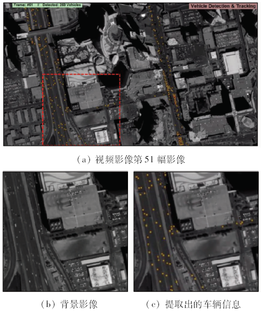
图4
3.2 自然灾害应急快速响应
在自然灾害应急快速响应方面,视频卫星可在自然灾害诱发期、灾害发生发展期、救灾与重建期进行全方位动态监测。如果遇到地震、台风、林火等突发性自然灾害以及渔船遇险等情况,视频卫星实时传回的动态观测影像能帮助救灾部门快速判断、决策。视频卫星还可以实时监视大洋环流、海面温度场的变化、鱼群的分布和迁移、污染物的运移等,有助于海洋渔业部门和环保部门采取相应的措施。未来,视频卫星的摄像机的波谱范围可扩展到红外波段,对发生火情的森林进行观测,通过温度感应,判断火灾蔓延情况和趋势,查找火源地点。
图5
3.3 重大工程监控
传统遥感影像时序监测常用于城镇用地变化监测,可在提取变化图斑的基础上,赋予变化类型的属性,计算变化面积以及类型转移情况,编制不同时期的土地利用变化图及统计表; 也可用于调查城镇扩展进程及演变规律、分析城镇扩展态势。与传统遥感卫星相比,视频卫星目标观测区域小,但时效性好,可实现小区域的定点、定范围遥感监测,使其在一些重大工程领域中有着得天独厚的应用优势,可为及时了解重大工程的进展、工程建设对周边生态环境的影响等提供实时的视频信息支持。
图6(a)与图6(b)分别对2013年12月21日和2015年1月18日我国高分一号卫星(GF-1)多光谱数据进行R(3),G(4),B(2)波段合成的江西省定南县的矿山图。该矿区属中低山地形地貌区,地势东南高、西北低,沟谷发育。图中可见,矿区(呈不规则紫红色影像纹)在2013—2015年间有向西南方向扩张趋势。但GF-1其空间分辨率为8 m,时间分辨率为4 d,无法实时监控矿山的开采状况、尾矿库堆放面积、采石场的规模和数量等。目前最常用的Landsat系列卫星重返周期为16 d,QuickBird卫星重返周期为4~6 d,WorldView卫星重返周期为1.7 d,使用现有的光学卫星都无法满足对矿山实时监测的需要,另外云雾、雨雪等气象因素也会导致测区有效成像覆盖时间的不确定。而视频卫星可以在1秒内连续拍摄25~30帧的影像,可以全面了解矿区的开采现状和环境的动态变化状况,预测未来矿区的变化趋势,为矿管部门决策提供依据。
图6

3.4 军事安全
战场态势和攻防布阵瞬息万变,需要快速、及时地提供战区的情报侦察信息。最初为了军事应用研制出了遥感卫星,后来遥感从军事专用领域扩展到了民用领域。进入21世纪后,军用遥感成像卫星“快门控制权”更为明显,只要有国家或机构对地表的任意一处场景感兴趣,就可以拍摄地球上任何一处地方的细节。高分辨率视频侦察卫星可以快速、实时、动态地监测对手的基本态势,了解其军事部署和重要军事目标的情况,提高了国家的战略侦察能力[24]。
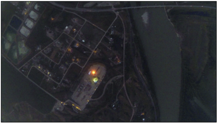
目前军用遥感最高空间分辨率为美国的“锁眼12号”卫星达0.1 m。对于时间分辨率,则可通过采用分布式星座缩短卫星的重访周期、扩大视场宽度等手段来提高。相信,视频卫星将是未来军事应用的重要发展方向。图7为谷歌地图中也门军事区的导弹炸毁地面的凹陷,可利用视频遥感卫星影像进行实时监测。
图7
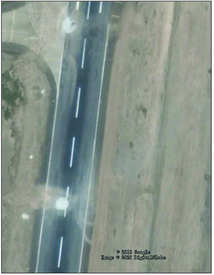
图8
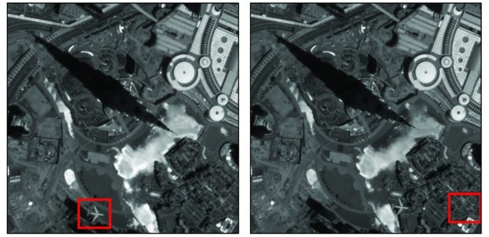
图8
SkySat-1对迪拜飞机实时监测
Fig.8
Real-time monitoring of Dubai aircraft from SatSat-1
4 结论
视频卫星的发展是技术进步推动和应用需求牵引的结果,也是未来对地观测的重要发展趋势。对于一个特定区域或应用,采用一颗视频卫星代替卫星组网,可降低成本、提升应急响应的速度,其优势在逐步显现。人类对空间信息时效性的需求越来越高,目前遥感获取信息的能力在时间分辨率上还存在局限性,视频卫星的出现和发展为满足高时间分辨率信息需求提供了可能,随之而来也对遥感数字图像处理在理论和技术上提出了新的要求,视频卫星的出现和发展将改变传统静态单景影像的图像处理模式,未来将发展为对多帧动态视频影像的快速图像处理模式。
视频卫星对目标区域进行长时间连续成像,可提供某地区动态信息,实现长时间动态实时监测,增强天基动态实时对地观测,服务于车辆实时监测、应急快速响应、重大基础设施监控以及军事安全等领域。当然,目前视频卫星尚未形成卫星组网,重返周期长,摄像机无法进行长时间连续工作,遥感传感器带来的海量数据仍存在遥感信息缺失、难解译等问题[26],对视频卫星的应用推广带来一定的难度。未来,视频卫星将形成太阳同步轨道的卫星组网以提高时间分辨率; 另外,星载、空载和地面立体视频成像将为某些特定应用提供更为可靠、及时的信息支持。
参考文献
Optical remotely sensed time series data for land cover classification:A review
[J].
DOI:10.1016/j.isprsjprs.2016.03.008
URL
[本文引用: 1]

Accurate land cover information is required for science, monitoring, and reporting. Land cover changes naturally over time, as well as a result of anthropogenic activities. Monitoring and mapping of land cover and land cover change in a consistent and robust manner over large areas is made possible with Earth Observation (EO) data. Land cover products satisfying a range of science and policy information needs are currently produced periodically at different spatial and temporal scales. The increased availability of EO data articularly from the Landsat archive (and soon to be augmented with Sentinel-2 data) oupled with improved computing and storage capacity with novel image compositing approaches, have resulted in the availability of annual, large-area, gap-free, surface reflectance data products. In turn, these data products support the development of annual land cover products that can be both informed and constrained by change detection outputs. The inclusion of time series change in the land cover mapping process provides information on class stability and informs on logical class transitions (both temporally and categorically). In this review, we present the issues and opportunities associated with generating and validating time-series informed annual, large-area, land cover products, and identify methods suited to incorporating time series information and other novel inputs for land cover characterization.
从对地观测卫星到对地观测脑
[J].
DOI:10.13203/j.whugis20160526
URL
Magsci
[本文引用: 1]
<p>21世纪以来,高分辨率对地观测卫星快速发展,对地观测系统由最初的单星模式发展为现在的轻小型卫星组建星座,实现了全天时、全天候、全方位的对地精细化观测。未来将对地观测卫星星座与通信卫星、导航卫星和飞机等空间节点通过动态组网,建立天基空间信息网络,以实现智能化空天信息的实时服务。为了进一步增强系统的智能化水平,提高系统感知、认知能力和应急响应能力,本文提出未来空间信息网络环境下对地观测脑(earth observation brain,EOB)的概念,对地观测脑是基于事件感知的智能化对地观测系统。详细介绍了对地观测脑的概念模型及需要解决的关键技术,举例说明了对地观测脑初级阶段的感知、认知过程。将来对地观测脑可以回答何时(when)、何地(where)、何目标(what object)发生了何种变化(what change),并在规定的时间(right time)和地点(right place)把这些正确的信息(right information)推送给需要的人(right people)的手机或其他智能终端,全球用户可实时获得所需的任何数据、信息和知识。</p>
From earth observation satellite to earth observation brain
[J].
国外视频卫星发展研究
[J].
Research of national and International video satellites
[J].
视频成像卫星发展现状与启示
[J].
低轨视频卫星成像特性分析
[J].
Imaging characteristics analysis for LEO video satellite
[J].
低轨道视频卫星任务模式的研究与应用
C]//卫星视频遥感是最近几年发展起来的一种新型对地观测方式。低轨道视频卫星具有高敏捷性、持续观测和低成本的特点,在对动态目标的跟踪和监测方面具有很广泛的应用潜力。本文建立了低轨道视频卫星的任务模型。对卫星星下点轨迹上的目标点,确定卫星拍视频的初始俯仰角,通过计算地心角的方法得到拍摄视频的时间长度。最大俯仰角15°时,视频图像具有最小畸变,时长为51秒,一圈轨道内最多可以拍摄16次视频。最大俯仰角40°时,拍摄视频的时间最长,为165秒,一圈轨道最多拍摄6次视频。
Research in task mode of low earth orbit video satellite
C]//
热核艺术的震撼:NASA发布30分钟太阳4K影像
[EB/OL].(
The shock of thermonuclear art: 4K video of sun about 30 minutes released by NANA
[EB/OL].(
商业遥感卫星市场的现状与发展趋势
[J].
我首颗视频成像体制微卫星"天拓二号"发射成功
[N/OL].
Tiantuo-2.China’s first video imaging system of micro satellite
[N/OL].
中国成功发射一颗米级高清动态视频卫星
[EB/OL].(
A nanometers HD dynamic video satellite as successfully launched in China
[EB/OL].(
空间视频成像市场前景尚不确定
[J].正2013年12月,美国天空 盒子成像(Skybox Imaging)公司的天空卫星-1(SkySat-1)成功拍摄到了人类历史上首段高分辨率、高清空间对地观测视频。作为世界上首颗具备视频成像能力的 高分辨率商业对地观测卫星,SkySat-1卫星可以拍摄长度不超过90秒的1080p高清全动态黑白视频。然而,当人们还在惊叹于Skybox公司伟大 壮举的同时,一场前所未有的空间视频成像市场之争已
Skybox公司高分辨率小微卫星星座开启商业遥感2.0时代
[J].
国外芯片卫星发展研究
[J].
揭秘“吉林一号”组星-我国航天遥感应用商业化产业化迈出重要一步
[EB/OL].(
Revelation of "Jilin-1" group star-a significant step of space remote sensing application commercialization industrialization in China
[EB/OL].(
视频小卫星凝视姿态跟踪的仿真与实验
[J].
DOI:10.3788/OPE.20111911.2715
Magsci
[本文引用: 2]
对视频卫星实现对地凝视成像时的数学模型、姿态跟踪控制器设计和全物理仿真进行了研究。首先,根据卫星轨道运动与姿态运动相关理论,推导了对地凝视时视频小卫星相对轨道坐标系的期望四元数和期望姿态角速度的变化规律。设计了基于误差四元数和误差姿态角速度的PD控制器,并采用李雅普诺夫稳定性理论证明了所设计控制器的稳定性。然后,以在曝光时间内的面阵CCD成像偏差不超过0.3 pixel为要求,给出了姿态角控制精度和姿态角速度控制精度的最小极限值。最后,在设计的基于小型三轴气浮台的小卫星姿态控制系统全物理仿真平台上对视频小卫星凝视摄像进行了仿真验证。实验结果表明,小型三轴气浮台的姿态角控制精度优于0.1°,姿态角速度控制精度优于0.01(°)/s,基本满足视频小卫星凝视时面阵CCD高质量成像的要求。
Simulation and experiment on attitude tracking control of small TV satellite
[J].
HJ1B星CCD相机内方位元素的在轨标定方法
[J].<p>为了获得内方位元素的在轨值,提高遥感影像的定位精度,利用线阵推扫传感器构象模型,提出了一种对HJ1B\|CCD相机内方位元素进行在轨标定的方法。首先,选取地面控制点,建立地面控制点和相应像点的共线方程组;其次,建立误差方程,估算未知参数的初值;最后,利用狭义岭估计的方法解算误差方程,获得内方位元素和外方位元素值。实验证明,用该方法对HJ1B\|CCD相机内方位元素进行在轨标定,具有较高的稳定性和精度。</p>
On-orbit calibration of interior orientation for HJ1BCCD camera
[J].
Vehicle detection and traffic density monitoring from very high resolution satellite video data
[C]//
Small moving vehicle detection in a satellite video of an urban area
[J].
DOI:10.3390/s16091528
URL
PMID:5038801
[本文引用: 1]
Vehicle surveillance of a wide area allows us to learn much about the daily activities and traffic information. With the rapid development of remote sensing, satellite video has become an important data source for vehicle detection, which provides a broader field of surveillance. The achieved work generally focuses on aerial video with moderately-sized objects based on feature extraction. However, the moving vehicles in satellite video imagery range from just a few pixels to dozens of pixels and exhibit low contrast with respect to the background, which makes it hard to get available appearance or shape information. In this paper, we look into the problem of moving vehicle detection in satellite imagery. To the best of our knowledge, it is the first time to deal with moving vehicle detection from satellite videos. Our approach consists of two stages: first, through foreground motion segmentation and trajectory accumulation, the scene motion heat map is dynamically built. Following this, a novel saliency based background model which intensifies moving objects is presented to segment the vehicles in the hot regions. Qualitative and quantitative experiments on sequence from a recent Skybox satellite video dataset demonstrates that our approach achieves a high detection rate and low false alarm simultaneously.
Traffic monitoring using very high resolution satellite imagery
[J].
DOI:10.14358/PERS.75.7.859
URL
[本文引用: 1]
Abstract Very high resolution satellite images allow automated monitoring of road traffic conditions. Satellite surveillance has several obvious advantages over current methods, which consist of expensive single-point measurements made from pressure sensors, video surveillance, etc., in/or close to the road. The main limitation of using satellite surveillance is the time resolution; the continuously changing traffic situation must be deduced from a snapshot image. In cooperation with the Norwegian Road Authorities, we have developed an approach for detection of vehicles in Quick-Bird images. The algorithm consists of a segmentation step followed by object-based maximum likelihood classification. Additionally, we propose a new approach for prediction of vehicle shadows. The shadow information is used as a contextual feature in order to improve classification. The correct classification rate was 89 percent, excluding noise samples. The proposed method tends to underestimate the number of vehicles when compared to manual counts and in-road equipment counts.
Vehicle detection in very high resolution satellite images of city areas
[J].
DOI:10.1109/TGRS.2010.2043109
URL
[本文引用: 1]
Current traffic research is mostly based on data from fixed-installed sensors like induction loops, bridge sensors, and cameras. Thereby, the traffic flow on main roads can partially be acquired, while data from the major part of the entire road network are not available. Today's optical sensor systems on satellites provide large-area images with 1-m resolution and better, which can deliver complement information to traditional acquired data. In this paper, we present an approach for automatic vehicle detection from optical satellite images. Therefore, hypotheses for single vehicles are generated using adaptive boosting in combination with Haar-like features. Additionally, vehicle queues are detected using a line extraction technique since grouped vehicles are merged to either dark or bright ribbons. Utilizing robust parameter estimation, single vehicles are determined within those vehicle queues. The combination of implicit modeling and the use of a priori knowledge of typical vehicle constellation leads to an enhanced overall completeness compared to approaches which are only based on statistical classification techniques. Thus, a detection rate of over 80% is possible with very high reliability. Furthermore, an approach for movement estimation of the detected vehicle is described, which allows the distinction of moving and stationary traffic. Thus, even an estimate for vehicles' speed is possible, which gives additional information about the traffic condition at image acquisition time.
高分辨率商业遥感卫星的发展及军事应用
[J].
高分辨率遥感卫星的发展及其军事应用探索
[J].
