

0 引言
MODIS是搭载于美国发射的太阳同步轨道系列卫星TERRA和AQUA上的主要传感器,它具有36个光谱通道,分布在0.4~14 μm的电磁波谱范围内。常用的MODIS水汽产品为近红外和热红外水汽产品。与热红外方法相比,近红外方法具有较高的反演精度。但是近红外水汽反演方法仅适用于白天,相比之下,能实现白天夜晚双时段观测的热红外水汽数据更适合业务应用。因此,提高热红外水汽反演结果的精度,有着非常重要的意义。
1 研究区概况及数据源
本文选择的研究区域为美国南部地区及中国山西省。美国南部地区属亚热带气候区,夏季较为炎热,冬季温暖,全年降水充足; 山西省属于温带大陆性季风气候,夏季南长北短,雨水集中,冬季漫长,寒冷干燥。文中采用MODIS数据进行研究。其中使用MOD02数据进行亮温反演,并代入投影寻踪模型进行水汽反演,使用MOD05数据进行对比。MOD02即MODIS_L1B数据,是MODIS原始数据经过辐射校正后的产品,MOD05是MODIS的水汽产品,其中包括了热红外和近红外2种。
水汽反演结果的验证数据及投影寻踪模型的学习数据为SuomiNet实验测得的全球定位系统(global positioning system,GPS)水汽数据和北京市城市气象研究所提供的GPS水汽数据。SuomiNet是由美国国家科学基金会资助,通过相关高校之间的合作建立的实时GPS地基观测网络,用于大气科学研究[13]。其在北美分布有近300个监测站点,每个站点利用GPS信号进行大气水汽反演,时间分辨率为0.5 h,在每小时的15分和45分进行监测。中国华北地区建立了较为完整的地基GPS观测网,中国气象局北京城市气象研究所实现了华北地区地基GPS观测资料的实时解算,数据时间分辨率为0.5 h。本文利用了山西省境内的59个GPS站点观测的水汽数据。
2 基本原理
2.1 热红外分裂窗反演水汽的基本原理
式中:
对普朗克公式进行一阶泰勒展开,可以得到
结合公式(2)对公式(1)进行化简,并用最小二乘法分析,可得到2通道透过率的比值形式,即
式中
研究表明[16],12 μm和10.8 μm波段的透射率的比值
从式(3)可以看出,水汽含量W与MODIS的31和32通道亮温(
2.2 投影寻踪的基本原理
设x是p维随机变量,y=f(x)是一维随机变量,为了避免线性回归不能反映实际非线性情况的矛盾,PPR用式(4)表示的一系列岭函数
式中:
式(4)可以写成矩阵表示形式,即
李祚泳等[19]采用了易于实现的免疫进化算法(immune evolutionary algorithm,IEA)优化PPR模型中的参数。因此,PPR的参数优化问题即是在满足目标极小化准则条件下,采用IEA优化式(5)中的参数矩阵
2.3 投影寻踪模型用于水汽反演的步骤
1)对MOD02数据进行处理,并计算
2)随机抽取部分GPS测量水汽数据(记作WGPS)作为因变量,找出相对应的
式中:
3)抽取其余的自变量作为检验样本代入训练后的投影寻踪模型,得到的结果与相对应的WGPS数据作比较,并计算其误差。
3 结果与讨论
3.1 投影寻踪模型代入变量的选取
为了增加投影寻踪模型的反演成功率,以美国南部地区2015年8月6日遥感影像为例讨论因变量(WGPS)与自变量(
3.1.1
在2015年8月6日遥感影像上随机抽取15个样本点,并记录每个样本点的
图1
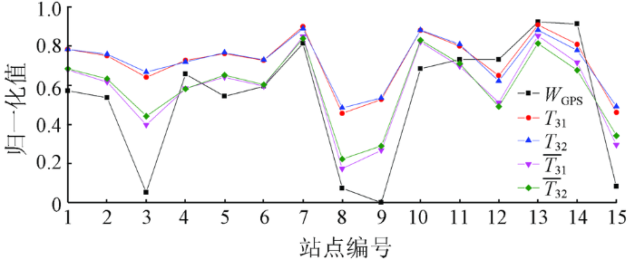
图2-1
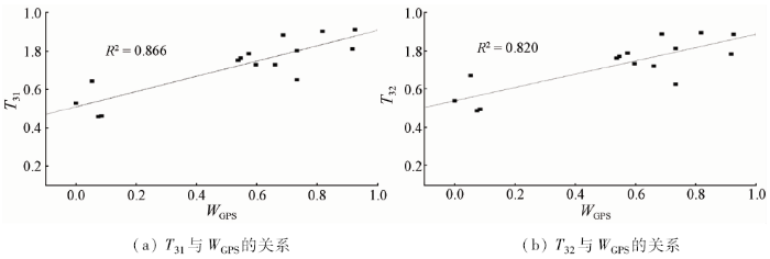
图2-2
3.1.2
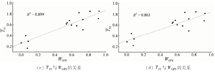
自变量的四则运算主要考虑
图3
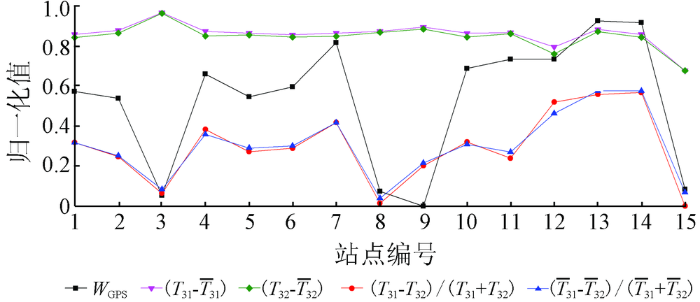
图3
部分亮温四则运算及
Fig.3
Normalization of arithmetie of brightness temperature and
图4
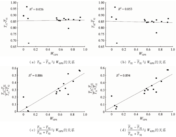
图4
Fig.4
Linear relationship between arithmetie of brightness temperature and
3.2 结果对比实验
本实验的目的在于测试各类代入变量,选取最优的变量组合。变量组合应满足以下2个条件:
1)由式(3)可知,W由
2)变量两两之间不能有重复因子,否则会影响模型对权重系数
因此代入变量可分为4组,第一组为
结合SuomiNet提供的站点经纬度坐标,在2015年8月6日美国南部地区的遥感影像上可以找到相应的59个样本点。从中随机选取50组作为训练样本,每组训练样本均包含输入变量和
为了方便与传统的模型相比较,实验下载了对应时间的MOD05热红外水汽数据,并从中选取了与9组反演样本相对应的像元点,参与比较(图5)。
图5
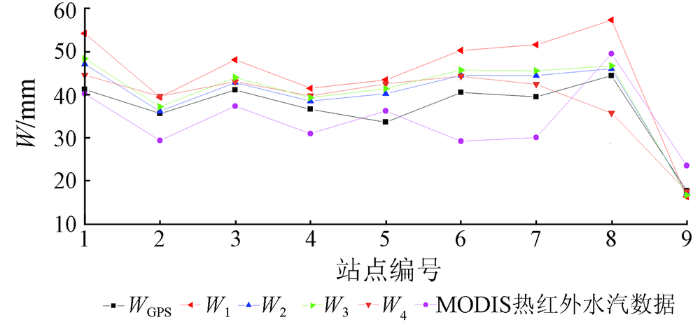
图5
美国南部地区水汽反演结果与
Fig.5
Comparison between the inversion results of water vaporwith
由图5可以看出,4组输入变量代入模型后反演的水汽结果和MODIS热红外水汽含量数据均能将
根据中国山西省GPS观测站点的地理坐标,在2011年7月27日的遥感影像上可以找到相应的51个样本点,从中随机选取42组作为训练样本,9组作为反演样本,采用与美国南部地区相同的方法进行实验,结果如图6所示。
图6
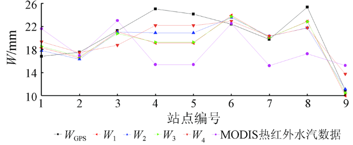
图6
中国山西省水汽反演结果与
Fig.6
Comparison between the inversion results of water vaporwith
山西省实验中MODIS热红外水汽产品与
美国南部地区试验结果中,
综合2次实验结果,
3.3 投影寻踪模型反演实验
为了验证投影寻踪模型反演水汽的可推广性,本文对美国南部地区及中国山西省分别做了水汽反演实验。
3.3.1 美国南部地区水汽反演实验
利用
图7
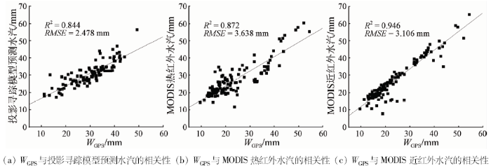
图7
3组模型水汽反演结果与
Fig.7
Comparison between inversion results of water vapor in three groups with
结果表明,在美国南部地区,
3.3.2 中国山西省水汽反演实验
利用
图8
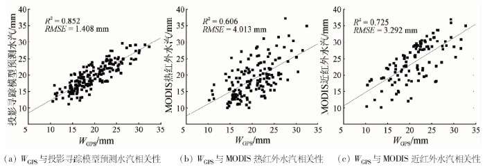
图8
投影寻踪模型水汽反演结果与
Fig.8
Comparison between the PPR inversion results of water vapor with
由图8可知,在山西省,
由2次实验可以看出,在美国南部地区,MODIS数据2种水汽产品的相关系数较高; 而在中国山西省,相关系数明显降低,反演精度也有了不同程度的下降。而投影寻踪模型反演的水汽无论在美国南部地区还是山西省均有较高的精度及相关系数,在山西省的精度甚至高于美国南部地区。由此可见,本文提出的算法具有一定的实用性和可推广性。
4 结论
1)本文对MODIS热红外通道展开了研究,结合投影寻踪模型,提出了一种新的遥感水汽反演算法。与传统的MODIS水汽反演方法相比,该方法比热红外反演具有更高的精度,而比近红外反演具有更高的时间分辨率,因此更具业务化推广的潜力。
2)利用该算法对美国南部地区及中国山西省的大气水汽含量进行反演,并用GPS水汽观测数据进行验证。其中美国南部地区反演结果的RMSE为2.478 mm,中国山西省的RMSE为1.408 mm,均低于相应热红外方法的RMSE,表明本文方法在2个实验区均能得到较好的反演结果。
3)
4)实验中的数据样本均取自大范围晴朗无云的遥感影像。而在我国南方地区常有云覆盖,在基于投影寻踪模型的遥感水汽反演算法中如何减少云覆盖的干扰还有待于做进一步的研究。
参考文献
GPS遥感区域大气水汽总量研究回顾与展望
[J].
Reviews and prospects of researches on remote sensing of regional atmospheric water vapor using ground-based GPS
[J].
用地面湿度参量计算我国整层大气可降水量及有效水汽含量方法的研究
[J].
DOI:10.3878/j.issn.1006-9895.2002.01.02
Magsci
[本文引用: 1]

根据1993年我国28个台站地面及高空气象要素资料,拟合出这28个台站所在地区整层大气可降水量同地面湿度参量(地面水汽压、地面露点)关系的经验表达式,并且在此基础上,通过引进地理纬度ψ和海拔高度H两个参量,将经验系数参数化,建立起由地面湿度参量计算整层大气可降水量的经验计算模式.另外还拟合出这些地区整层大气有效水汽含量同可降水量关系的经验表达式,提出一个先由地面湿度参量计算整层大气可降水量,再由此计算出整层大气有效水汽含量的方法.
A method for estimating precipitable water and effective water vapor content from ground humidity parameters
[J].
双台风生消过程涡旋能量、水汽输送相互影响的三维物理图像
[J].
DOI:10.11676/qxxb2013.069
URL
Magsci
[本文引用: 1]
重点研究“莫拉克”台风发展并登陆台湾,以及“天鹅”台风消亡阶段两者相互作用的问题。通过诊断分析发现“莫拉克”与“天鹅”移动过程存在双台风涡旋互旋、吸引与合并现象。采用双台风中心连线的垂直剖面移动坐标分析法可揭示出双台风涡度、风场三维结构,演变过程中双台风的涡度、动能强度呈反向变化关系,在双台风生消过程中,动能、位涡场分布存在显著“连体”通道特征。并揭示出双台风涡旋各自生、消过程水汽、动能可能存在的相互影响及其涡旋结构变化的内在关联。对“天鹅”消亡、“莫拉克”引发暴雨过程,采用Flexpart-WRF耦合模式模拟“质点群”轨迹,模拟结果再现了双台风生消阶段“天鹅”台风水汽“粒子群”向“莫拉克”低层气旋式输入通道,且在“莫拉克”涡旋高层反气旋式卷出的三维立体动态图像。通过剔除“天鹅”台风涡旋数值模拟试验进一步印证了“天鹅”台风趋于消弱过程其水汽、动能输送为“莫拉克”台风发展与维持做出了一定贡献。基于以上合成分析、轨迹和数值模拟技术综合分析提出了能揭示“天鹅”消亡、“莫拉克”发展过程能量、水汽输送相互影响的三维物理图像。
The structure change and energy moisture transport physical image in the development and decay processes of binary typhoon vortices
[J].
静止气象卫星水汽图像的分析和应用(一)
[J].
DOI:10.1007/s00376-999-0032-1
URL
[本文引用: 1]
Experiments and detections of rain enhancement over a long period show that water vapor condition is an important and basic requirement for weather modification. An initiative analysis for three torrential rain processes of Heilongjiang Province in July of 1995, based on the water vapor images of GMS-5 with 6.7 m channel which were offered recently and combined with the conventional weather data and satellite cloud picture etc, was made. It is shown that the three processes corresponded with three different types, respectively. A synthetical study of the continuous torrential rain process with an obvious water vapor band during 25~30, July was made. The water vapor images provided a clear and object imagery for the water vapor transfer band in warm area during the developing stage of this typical cyclone, therefore, the data for width and length of water vapor transfer band were obtained and the structures of temperature and humidity were analysed. The precipitation efficiency in the warm front was also estimated. Furthermore, the cloud physical characteristics of the precipitation process and the conditions for rain enhancement were analysed. So, the possibility of application of water vapor images in weather modification would be provided
Analysis and application of GMS 5 water vapor images (I)
[J].
高原低涡东移过程的水气图像
[J].
Water vapor imagery of vortex miving process over Qinghai-Xizang Plateau
[J].
MODIS Atmospheric Profile Retrieval Algorithm Theoretical Basis Document
[M].
Operational retrieval of atmospheric temperature, moisture,and ozone from MODIS infrared radiances
[J].DOI:10.1175/1520-0450(2003)042<1072:OROATM>2.0.CO;2 URL [本文引用: 1]
MODIS infrared (IR) water vapor calibration model and assessment
[C]//
A multi-sensor study of water vapour from radiosonde,MODIS and AERONET:A case study of Hong Kong
[J].DOI:10.1002/joc.v33.1 URL [本文引用: 1]
The annual cycle of total precipitable water vapor derived from different remote sensing techniques:An application to several sites of the Iberian Peninsula
[C]//
MODIS近红外水汽产品的检验、改进及初步应用——以黑河流域金塔绿洲为例
[J].利用野外观测资料检验MODIS近红外水汽产品表明,该产品精度较低,不适合研究区大气水汽含量分析研究.考虑误差产生的原因,调整空间分辨率并引入地表覆盖类型信息进行反演,结果表明,反演的平均相对误差为4.47%,绝对误差为0.0456g/cm2,说明改进后结果有较大改善,精度较高.同时使用MODTRAN模拟出大气水汽含量与透过率存在较好的负相关关系,并据此计算大气透过率,为下一步计算地表温度及能量平衡中的各分量奠定基础.APPLICATION OF MODIS NEAR INFRARED WATER VAPOR PRODUCTS
Testing,improvement and application of MODIS near infrared water vapor products-taking Jinta oasis in Heihe River basin as a case study
[J].
遥感影像投影寻踪回归分类模型
[J].
DOI:10.11834/jig.20121216
URL
Magsci
[本文引用: 1]
将投影寻踪回归分析技术引入遥感影像分类中,详尽叙述遥感影像投影寻踪回归分类模型的建立和实现过程。将广州地区的TM影像用于分类实验,并用混合蛙跳算法来优化投影寻踪回归分类模型中的参数矩阵,取得了较为理想的分类效果。此外,还进一步分析了投影中心的设定、调整以及优化算法和岭函数个数对投影寻踪回归模型分类精度的影响。实验结果表明,该模型易于优化实现,稳定性强,模型中岭函数的个数对投影寻踪回归模型的分类精度没有显著影响。
Remote sensing image classification model based on projection pursuit regression
[J].
SuomiNet:A real-time national GPS network for atmospheric research and education
[J].
DOI:10.1175/1520-0477(2000)0812.3.CO;2
URL
[本文引用: 1]
"SuomiNet, " a university—based, real—time, national Global Positioning System (GPS) network, is being developed for atmospheric research and education with funding from the National Science Foundation and with cost share from collaborating universities. The network, named to honor meteorological satellite pioneer Verner Suomi, will exploit the recently shown ability of ground—based GPS receivers to make thousands of accurate upper— and lower—atmospheric measurements per day. Phase delays induced in GPS signals by the ionosphere and neutral atmosphere can be measured with high precision simultaneously along a dozen or so GPS ray paths in the field of view. These delays canbe converted into integrated water vapor (if surface pressure data or estimates are available) and total electron content(TEC), along each GPS ray path. The resulting continuous, accurate, all—weather, real—time GPS moisture data will helpadvance university research in mesoscale modeling and data assimilation, severe weather, precipitation, cloud dynamics, regional climate, and hydrology. Similarly, continuous, accurate, all—weather, real—time TEC data have applications in modeling and prediction of severe terrestrial and space weather, detection and forecasting of low—altitude ionospheric scintillation activity and geomagnetic storm effects at ionospheric midlatitudes, and detection of ionospheric effects induced by a variety of geophysical events. SuomiNet data also have potential applications in coastal meteorology, providing ground truth for satellite radiometry, and detection of scintillation associated with atmospheric turbulence inthe lower troposphere. The goal of SuomiNet is to make large amounts of spatially and temporally dense GPS—sensed atmospheric data widely available in real time, for academic research and education. Information on participation in SuomiNet is available via www.unidata.ucar.edu/suominet.
Total water vapor column retrieval from MSG-SEVIRI split window measurements exploiting the daily cycle of land surface temperatures
[J].DOI:10.1016/j.rse.2007.05.006 URL [本文引用: 1]
Temperature-independent spectral indices in thermal infrared bands
[J].
DOI:10.1016/0034-4257(90)90095-4
URL
[本文引用: 1]
In order to perform spectral analysis in the thermal infrared bands, temperature-independent thermal infrared spectral indices (TISI) are derived from observable thermal infrared radiances. Being temperature-independent and simply related to spectral emissivities of the observed surface, these indices are as easy to use to perform spectral analysis as reflectances in the visible and near infrared spectral domains. Examples of such indices are given for TIMS and AVHRR. Several properties of these indices are discussed, particularly their sensitivity to spectral emissivity variation, their efficient combination, and the derivation of relative spectral emissivity. These indices are quite complementary to NDVI and can lead to stronger results if used together rather than separately. For instance, in the examples worked out, these indices are more sensitive to bare soils characteristics than NDVI. Furthermore, these indices can be tailored to weight certain bands more heavily than others, giving to these indices a wide range of application. They may, for instance, be used for geologic compositional mapping. Practical examples from TIMS and AVHRR data are shown and briefly discussed with a possible applications to the determination from AVHRR data of the surface temperature and surface emissivity.
A new approach for retrieving precipitable water from ATSR2 split-window channel data over land area
[J].DOI:10.1080/0143116031000096014 URL [本文引用: 1]
Unsupervised BCM projection pursuit algorithms for classification of simulated radar presentations
[J].DOI:10.1016/0893-6080(94)90047-7 URL [本文引用: 1]
基于投影寻踪聚类模型的龙坑水源地地下水水质评价
[J].
Assessment of water quality of groundwater in Longkeng based on projection pursuit cluster model
[J].
