

0 引言
利用遥感技术开展围岩蚀变信息(蚀变矿物)提取研究已有近半个世纪的历程。受岩浆热液作用影响,斑岩型矿床具有良好的水平和垂向蚀变矿物分带特征[4]。近些年的研究表明,遥感蚀变矿物(组合)提取技术能有效识别斑岩铜矿围岩蚀变的分带特征[5,6]。目前,TM,ETM+,ASTER,Hyperion和Landsat8 OLI等遥感数据,在遥感蚀变信息(蚀变矿物组合)提取和识别方面应用广泛[7,8]。TM和ETM+数据常用来提取铁染和泥化蚀变信息[9,10,11,12],也有研究者用来进行铁镁质岩石信息的识别[12,13,14]。其中,主成分分析法(principal component analysis,PCA)是最常用的技术方法。ASTER数据在SWIR和TIR波谱区间的波谱分辨率提高,使得ASTER数据在蚀变矿物(信息)提取和岩性信息识别等方面应用也较广,通常用来识别Mg-OH类、Al-OH类、C
以班公湖—怒江成矿带多龙矿集区铁格隆斑岩铜矿远景区为例,在对铁格隆远景区各蚀变带蚀变矿物(组合)波谱分析的基础上,利用混合调制匹配滤波(mixture tuned matched filtering,MTMF)方法开展基于OLI数据的蚀变矿物组合提取研究,并与Hyperion高光谱数据提取结果进行对比验证,初步分析铁格隆远景区基于OLI数据的蚀变矿物组合分带特征。
1 研究区概况
青藏高原是聚合板块最发育的地区,对斑岩型铜矿床及伴生矿床形成十分有利,具有良好的斑岩型铜矿床成矿前景,已经成为我国最重要的矿产资源基地之一[2,26-27]。青藏高原气候干旱、空气稀薄、植被稀疏、基岩裸露等特点,也为遥感蚀变矿物识别和提取提供了良好的地表环境。其中,西藏多龙矿集区大地构造位置属三江构造系(一级构造单元)、羌塘弧盆地系(二级构造单元)、扎普—多不杂岩浆弧(三级构造单元),位于班公湖—怒江结合带西段,是冈底斯陆块与羌塘陆块的分界线[28]。多龙矿集区中的铁格隆斑岩铜矿远景区作为本文研究区域,主要出露下侏罗统曲色组(J1q)、中侏罗统色哇组(J2s)以及第四系(Q4); 岩浆岩较发育,主要有花岗闪长斑岩和辉长岩等[29]。研究区工作程度较低,在地表和钻孔内见硅化、绢云母化、褐铁矿化和角岩化[29],地表常见蚀变矿物主要有褐铁矿、绢云母、高岭石、石英、绿泥石和绿帘石等。
2 遥感数据源与矿物波谱特征分析
2.1 遥感数据源
Landsat8 OLI数据VNIR波谱区间有6个波段,SWIR波谱区间有3个波段,波段设置如表1所示。
表1 OLI数据波段设置
Tab.1
| 波段号 | 波长范围/μm | 空间分辨率/m |
|---|---|---|
| 8 (pan) | 0.520~0.680 | 15 |
| 1 (Coastal) | 0.433~0.453 | 30 |
| 2 (Blue) | 0.450~0.515 | |
| 3 (Green) | 0.525~0.600 | |
| 4 (Red) | 0.630~0.680 | |
| 5 (NIR) | 0.845~0.885 | |
| 9 (Cirrus) | 1.360~1.390 | |
| 6 (SWIR1) | 1.560~1.660 | |
| 7 (SWIR2) | 2.100~2.300 |
OLI数据获取于2015年11月22日,为经过几何校正的L1T产品,地理参考为UTM投影WGS坐标系。Hyperion数据获取于2004年10月30日,为L1R产品,没有地理参考,需要以OLI数据为基准进行几何校正。为了削弱大气散射和吸收等影响,OLI数据进行了辐射定标和基于MODTRAN(moderate resolution transmittance)辐射传输模型的大气校正等预处理; Hyperion数据进行了坏波段去除、辐射定标、坏线修复、条纹去除、Smile效应去除、基于MODTRAN辐射传输模型的大气校正和几何校正等预处理,几何校正误差控制在0.5个像元以内。
2.2 矿物波谱特征分析
利用SVC HR-1024波谱仪采集了地表常见蚀变矿物褐铁矿、高岭石、白云母和绿泥石等的野外光谱,并对野外采集矿物波谱、USGS波谱库矿物波谱和基于OLI波谱重采样的USGS矿物波谱进行了对比分析,对比结果示意图如图1所示。
图1
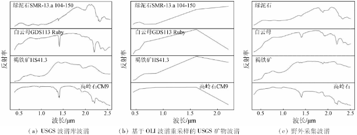
从图1(a)和(c)中可以看出: ①绢英岩化带中富含白云母(绢云母),白云母在2.20 μm附近(2.13~2.27 μm之间)具Al-OH类矿物吸收特征[30,31,32],VIR波谱区间反射率较低; ②褐铁矿在0.5 μm和0.9 μm附近具吸收特征,是Fe3+类矿物的诊断性谱段[32,33,34],VNIR波谱区间反射率较低; ③高岭石为泥化带典型蚀变矿物,在2.05~2.24 μm之间具双吸收特点[32,34],其他波谱区间反射率较高; ④绿泥石为青磐岩化带的典型蚀变矿物,通常主要为铁绿泥石和镁绿泥石,绿泥石在2.32 μm附近(2.28μm~2.40μm之间)具强吸收特征,主要是由Mg-OH类矿物引起,而在0.90 μm附近的吸收特征主要是由Fe3+类矿物引起[33,34],VNIR波谱区间反射率低于SWIR。对应OLI数据重采样波谱(图1(b)),高岭石和白云母在SWIR2波段具有吸收特征; 相反,绿泥石在SWIR2波段具有反射特征; NIR波段褐铁矿和绿泥石波谱都具有一定的吸收特征,但区别于褐铁矿,绿泥石在红光波段也具有一定的吸收特征,褐铁矿则为反射特征; 而褐铁矿在蓝光波段具吸收特征。
通过对比OLI与TM和ETM+的波段设置,调整较大的为NIR波段(0.845~0.885 μm)和SWIR2波段(2.100~2.300 μm); NIR波段波谱宽度变窄,排除了0.825 μm 处水汽吸收的影响,并且位于褐铁矿吸收谷位置,成为含Fe3+类矿物的诊断性谱段; SWIR2波段光谱分辨率的提高,消除了C
3 蚀变矿物提取与分析
3.1 提取方法
MTMF方法是一种高光谱数据制图方法,近年来被广泛应用到多光谱蚀变矿物提取中[24,35-36]。该方法通过对目标波谱的最优线性检测与评估,在混合像元分解基础上,反演每个像元中不同探测目标的丰度[37]。该方法主要基于目标波谱的整体形态,矿物波谱特征分析时,不仅分析了矿物的吸收特征,还分析了矿物的整体波谱形态及吸收特征对整体形态的影响。匹配结果由2个部分构成,分别记录了目标端元波谱的匹配程度得分和不可信度得分,匹配得分与不可信度得分比值则能较好地表达蚀变矿物丰度信息[38]。MTMF方法提取蚀变矿物时,还需要以最小噪声分离(minimum noise fraction rotation,MNF)、纯净像元指数计算、N维散点图纯净像元(端元)选取和端元波谱分析(端元识别)等系列数据处理为基础。
3.2 OLI数据蚀变矿物提取
表2 OLI数据3种端元USGS波谱库波谱SAM得分
Tab.2
| 端元编号 | 矿物名称 | SAM 得分 |
|---|---|---|
| 1 | 高岭石+蒙脱石+白云母 | 0.912+0.893+0.886 |
| 2 | 绿泥石+绿帘石 | 0.915+0.901 |
| 3 | 黄钾铁矾+赤铁矿 | 0.818+0.792 |
图2

从图2中可以看出,Al-OH类蚀变矿物信息主要呈EW向串珠状集中展布,分布于研究区中部; Mg-OH类蚀变矿物信息大面积团块分布于研究区西南部,东部、北部有零星分布; 铁染类蚀变矿物信息团分布在Al-OH类和Mg-OH类蚀变矿物信息之间,斑块状分布。OLI数据遥感蚀变矿物空间分布基本符合斑岩铜矿围岩蚀变分带特征,即由内而外分别是Al-OH类蚀变矿物(绢云母化+泥化)、铁染类蚀变矿物和Mg-OH类蚀变矿物(青磐岩化)。
3.3 Hyperion数据蚀变矿物提取
表3 Hyperion数据4种端元USGS波谱库SAM匹配得分
Tab.3
| 端元编号 | 矿物名称 | SAM 得分 |
|---|---|---|
| 1 | 白云母 | 0.864 |
| 2 | 高岭石+蒙脱石 | 0.859+0.825 |
| 3 | 绿泥石 | 0.888 |
| 4 | 黄钾铁矾+针铁矿+褐铁矿 | 0.837+0.819+0.813 |
图3

3.4 OLI和Hyperion数据遥感蚀变分带特征
2种数据遥感蚀变分带特征如图4所示。
图4

图4
OLI和Hyperion数据遥感蚀变分带特征
Fig.4
Characteristics of remote sensing alteration zones of OLI and Hyperion data
从图4中可以发现,OLI数据Al-OH类矿物主要包含白云母、高岭石和蒙脱石信息,对应斑岩铜矿的绢英岩化+泥化蚀变带,分布在内带; Mg-OH类矿物主要包含绿泥石信息,绿泥石是青磐岩化带主要蚀变矿物,对应青磐岩化蚀变带,分布在外带; OLI数据和Hyperion数据铁染类蚀变矿物空间分布基本一致,主要分布在内外带之间。在图4(a)中,铁格隆斑岩铜矿远景区围岩蚀变由中心向外围依次是Al-OH类(绢云母+高岭石+蒙脱石)和Mg-OH类(绿泥石)蚀变矿物组合分带,对应为绢英岩化+泥化带和青磐岩化带围岩蚀变分带特征,铁染类矿物组合则分布在绢英岩化+泥化带和青磐岩化带之间; 在图4(b)中,铁格隆斑岩铜矿远景区围岩蚀变由中心向外围依次是绢云母、绢云母+高岭石、高岭石和绿泥石4种蚀变矿物组合分带,对应于绢英岩化带→绢英岩化带叠加泥化带→泥化带→青磐岩化带的围岩蚀变分带特征,青磐岩化带在矿区的西南部最为发育。总体上,OLI和Hyperion数据遥感蚀变分带特征一致,符合斑岩铜矿围岩蚀变分带特征。
4 结论与展望
通过分析斑岩型铜矿典型蚀变矿物(组合)在Landsat8 OLI数据各波段的吸收和反射特征,基于MTMF方法进行了西藏多龙矿集区铁格隆研究区地表蚀变矿物组合的提取研究,得出以下结论:
1)对比Hyperion数据蚀变矿物信息提取结果,OLI数据能够有效区分和识别Al-OH类、Mg-OH类和含Fe3+类蚀变矿物信息。
2)对应斑岩型矿床地表蚀变分带模型,OLI数据Al-OH类(绢英岩化+泥化)、Mg-OH类(青磐岩化)和含Fe3+类遥感蚀变矿物组合的分带特征良好。
此外,OLI数据较TM和ETM+数据将热红外波段细分为TIR1和TIR2 2个波段,其中,硅化蚀变矿物在TIR2波段(11.5~12.51 μm)具有强吸收特征,对识别硅化蚀变矿物信息十分有利; 矽卡岩型铜矿围岩蚀变中富C
参考文献
Porphyry copper systems
[J].DOI:10.2113/gsecongeo.105.1.3 URL [本文引用: 1]
西藏斑岩铜矿的前景展望
[J].
Looking forward to the prospects of porphyry copper deposits in Tibet
[J].
Lateral and vertical alteration-mineralization zoning in porphyry ore deposits
[J].
DOI:10.2113/gsecongeo.65.4.373
URL
[本文引用: 1]

ABSTRACT The geologic history of the San Manuel-Kalamazoo deposit has provided an opportunity for the examination of vertical and horizontal zoning relationships in a porphyry copper system. Precambrian Oracle "granite," a Laramide monzonite porphyry, and a Laramide dacite porphyry are hosts to zones of potassic, phyllic, argillic, and propylitic assemblages shown to be coaxially arranged outward from a potassic core through phyllic, argillic, and propylitic zones. Alteration zones at depth comprise an outer chlorite-sericite-epidote- magnetite assemblage yielding to an inner zone of quartz-K4eldspar-sericite- chlorite. Mineralization zones are conformable to the alteration zones, the ore zone (with a 0.5% Cu cutoff) overlapping the potassic and phyllic zones. Occurrence of sulfides changes upward and outward from dissemination at the low-grade core of the deposit through microveinlet to veinlet and finally vein occurrence indicating the progressively increasing effect of structural control. Several aspects of San Manuel-Kalamazoo geology suggest that it is exemplary of the porphyry copper deposit group. To test that idea and to evolve three-dimensional aspects of these deposits, a table of geologic characteristics of 27 major porphyry deposits is presented. Consideration of the table indicates that the "typical" porphyry copper deposit is eraplaced in late Cretaceous sediments and metasediments and is associated with a Laramide (65 m.y.) quartz monzonite stock. Its host intrusive rock is elongate-irregular, 4,000 X 6,000 feet in outcrop, and is progressively differen-tiated from quartz diorite to quartz monzonite in composition. The host is more like a stock than a dike and is controlled by regional-scale faulting. The orebody is oval to pipelike, with dimensions of 3,500 X 6,000 feet and gradational boundaries. Seventy percent of the 140 million tons of ore occurs in the igneous host rocks, 30 percent in preore rocks. Metal values include 0.45% hypogene Cu with 0.35% supergene Cu, and 0.015% Mo. Alteration is zoned from potassic at the core (and earliest) outward through phyllic (quartz-sericite-pyrite), argillic (quartz-kaolin-montmorillonite), and propylitic (epidote-calcite-chlorite), the propylitic zone extending 2,500 feet beyond the copper ore zone. Over the same interval, sulfide species vary from chalcopyrite-molybdenite-pyrite through successive assemblages to an assemblage of galena-sphalerite with minor gold and silver values in solid solution, as metals, and as sulfosalts. Occurrence characteristics shift from disseminations through respective zones of microveinlets (crackle fillings), veinlets, veins, and finally to individual structures on the periphery which may contain high-grade mineralization. Breccia pipes with attendant crackle zones are common. Expression of zoning is affected by exposure, structural and compositional homogeneity, and postore faulting or intrusive activity. Vertical dimensions can reach 10,000 feet, with the upper reaches of the porphyry environment perhaps only at subvolcanic depths of a few thousand feet. The vertical and lateral zoning described is repeated with sufficient constancy that depths of exposure at many deposits can be cited against the model of San Manuel-Kalamazoo. Several lines of evidence suggest relatively shallow depths of formation and significant variations in water content in the porphyry environment. Shallow emplacement is consistent with the appearance of breccia pipes associated with ring and radial diking and with vertically telescoped zoning. Models of the source of altering-mineralizing fluids are considered.
Distribution of hydrothermally altered rocks in the Reko Diq,Pakistan mineralized area based on spectral analysis of ASTER data
[J].DOI:10.1016/j.rse.2006.05.014 URL [本文引用: 1]
Integrating data of ASTER and landsat-8 OLI(AO) for hydrothermal alteration mineral mapping in Duolong porphyry Cu-Au deposit,Tibetan Plateau,China
[J].DOI:10.3390/rs8110890 URL [本文引用: 1]
基于物理意义的二维散点图类型划分与遥感蚀变信息提取
[J].
Type classification of 2D scatter plot of remote sensing image based on the physical meaning and extraction of remote sensing alteration information
[J].
遥感蚀变信息多层次分离技术模型与应用研究
[J].<p>根据自然物质系统具有层次结构的特性,在多年实践的基础上,对遥感蚀变信息提取问题提出了多层次分离技术模型。在这个技术模型框架下,首先讨论了遥感蚀变信息提取这一复杂研究对象的简化问题; 然后系统地阐述了该技术模型的基本原理和模型结构,以及该模型框架下的主要技术体系。应用实例分析结果表明,该模型所提出的技术思想不仅简化了遥感蚀变信息提取问题的复杂性,而且在实际应用中显现出良好的实用性。</p>
The model and application of multi-level detaching technique of remote sensing alteration information
[J].
Spectrum spatial structure characteristic analysis of remote sensing alteration information and interference factors
[J].DOI:10.1007/s11771-009-0107-2 URL [本文引用: 1]
Application of spectral analysis to discriminate hydrothermal alteration zones at Daralu copper deposit,SE Iran
[J].
西藏尕尔穷铜金矿多光谱遥感地质特征与外围找矿预测
[J].尕尔穷铜金矿的发现是近年来在西藏班公湖-怒江成矿带西段取得的重要找矿突破之一,目前已发现的矿体类型主要有接触交代矽卡岩型和构造破碎带型2种。前人在该区的研究已经注意到矽卡岩与花岗斑岩的成生联系,斑岩型矿产的成矿潜力较大。该文利用多光谱遥感图像,以寻找区内斑岩型矿床为目标,开展了线性构造、环形构造、铁帽类色要素和围岩分带的遥感解译,基于主成分分析法提取了遥感羟基异常和铁染异常。研究结果表明: 区内主要发育NW-NNW向、NE-NNE向和近SN向3组线性构造; 环形构造按组合样式可划分为5个环形构造系; 铁帽类色要素与遥感异常较吻合; 区内围岩分带较复杂,但多属斑岩铜矿成矿的有利围岩。综合分析认为,5个环形构造系为进一步找矿的重点区域。
Remote sensing geological characteristics and ore prediction in the Ga’erqiong Cu-Au deposit,Tibet
[J].
Mineralogical and structural characterization of alteration zones detected by orbital remote sensing at Shalatein District,SE Desert,Egypt
[J].DOI:10.1016/j.jafrearsci.2004.06.003 URL [本文引用: 2]
Spectral transformation of ASTER and Landsat TM bands for lithological mapping of Soghan ophiolite complex,south Iran
[J].DOI:10.1016/j.asr.2014.04.022 URL [本文引用: 1]
藏东罗布莎蛇绿岩遥感岩矿信息提取方法研究
[J].<p>为研究如何利用遥感技术进行蛇绿岩岩矿信息识别和提取,以藏东罗布莎蛇绿岩为例,基于ETM和ASTER遥感数据,分别采用比值法和主成分分析法提取羟基类(蛇纹石、绿泥石)和铁染类(磁铁矿、橄榄石)矿物信息; 利用纯净像元指数法(pure pixel index,PPI)提取端元波谱,结合地面已知岩性信息,分别采用光谱角分类法(spectral angle mapping,SAM)和波谱特征拟合法(spectral feature fitting,SFF)识别纯橄岩和橄榄岩,研究了罗布莎蛇绿岩及其主要蚀变矿物的空间分布特征。经过对比分析可知,用多种方法、多种数据提取的岩矿信息可以相互验证; 提取出的纯橄岩和橄榄岩与所提取的羟基类和铁染类蚀变遥感异常信息有较好的空间重叠,且与地面调查结果基本吻合。研究表明,该方法用于蛇绿岩遥感岩矿信息提取是可行的,并取得较好的地质效果。</p>
Study of methods for extraction of remote sensing information of rocks and altered minerals from Luobusha ophiolite in East Tibet
[J].
Regional-scale mineral mapping using ASTER VNIR/SWIR data and validation of reflectance and mineral map products using airborne hyperspectral CASI/SASI data
[J].DOI:10.1016/j.jag.2014.04.014 URL [本文引用: 1]
Hydrothermal alteration mapping using ASTER data in the Infiernillo porphyry deposit, Argentina
[J].
DOI:10.1016/j.oregeorev.2006.05.004
URL
[本文引用: 1]
The Infiernillo Cu–(Mo) porphyry deposit is located in the San Rafael Massif, in southern Mendoza Province, Argentina. It is hosted by and genetically related to Lower Permian Gondwanan volcanic rocks, which developed in a magmatic arc tectonic setting. The alteration zone has an oval shape about 302km × 202km in size, with a NNE–SSW strike. It consists of a small central quartz neck with appreciable hematite surrounded by an intense quartz-injected zone with local pervasive potassic alteration. Outwards there is a well-developed phyllic halo with intense bleaching which consists of pervasive and vein-type silicification, sericitization and pyritization. Cu and Mo anomalies are approximately coincident and are located between the silicified zone and the phyllic halo. In the outer part of the alteration zone, small polymetallic veins with pyrite, arsenopyrite, galena and minor chalcopyrite, sphalerite and electrum in quartz gangue crop out. An Advanced Spaceborne Thermal Emission and Reflection Radiometer (ASTER), with three visible and near infrared (VNIR) bands, six shortwave infrared (SWIR) bands and five thermal infrared (TIR) bands, was used to characterize the Infiernillo porphyry deposit alteration area. A circular zoning pattern was clearly observed in the VNIR + SWIR band combination. Spectral analysis of the surface reflectance SWIR detected 2.20 and 2.2602μm absorptions. Field data and sample spectroscopic analyses obtained using a GER 3700 spectral radiometer and a SWIR reflectance spectrometer (Portable Infrared Mineral Analyzer PIMA) showed a good correlation with the ASTER data. The 2.2002μm absorptions, due to Al-hydroxyl, reveal the presence of clay minerals (Al-illite, kaolinite) and sericite, whereas the 2.2602μm absorption due to Fe-hydroxyl, resulted from jarosite. The field samples were also analyzed with a TIR portable spectrometer Micro-FTIR model 102. The TIR was useful for detecting surface silica and potassic alteration through analysis of five-band surface emissivity data. ASTER images provided preliminary mineralogic information and geo-referenced alteration maps at low cost and with high accuracy. In this way ASTER has been proven to be a powerful tool in the initial steps of ore deposit exploration.
Lithologic mapping in the Mountain Pass,California area using Advanced Spaceborne Thermal Emission and Reflection Radiometer(ASTER) data
[J].DOI:10.1016/S0034-4257(02)00127-X URL [本文引用: 1]
Enhancement of hydrothermal alteration zones using the spectral feature fitting method in Rabor Area,Kerman,Iran
[J].DOI:10.1007/s12517-011-0495-0 URL [本文引用: 1]
热红外遥感定量反演地表岩石的SiO2含量
[J].
Quantitative inversion of the SiO2 content in surface rocks using thermal infrared remote sensing
[J].
ETM+(TM)蚀变遥感异常提取方法研究与应用——方法选择和技术流程
[J].从原理、模型试验及实际数据处理等方面分析对比了比值法、光谱角法及主分量分析法的优劣;选择了以主分量分析为主、光谱角法为辅进行蚀变遥感异常的提取;引用了误差理论某些基本概念,以标准离差σ作为遥感异常切割的尺度;建立了"去干扰异常主分量门限化技术流程"。以西藏驱龙—甲马蚀变遥感异常群为例,展示了此技术的效果,并与高光谱研究结果进行了比较。
The methods for extraction of alteration anomalies from the ETM+(TM) data and their application:Method selection and technological flow chart
[J].
Hydrothermal alteration mapping from Landsat-8 data,Sar Cheshmeh copper mining district,south-eastern Islamic Republic of Iran
[J].DOI:10.1016/j.jtusci.2014.11.008 URL [本文引用: 1]
基于主成分分析法的OLI数据蚀变信息提取——以西藏多龙铜金矿集区为例
[J].
Alteration information extraction based on principal component analysis using OLI data:A case study of Doloong Cu-Au deposit,Tibet
[J]
基于背景多层次分离的遥感矿化蚀变信息提取模型及应用实例
[J].
DOI:10.11873/j.issn.1004-0323.2015.3.0586
URL
Magsci
[本文引用: 2]
<p>基于背景多层次分离的遥感矿化蚀变信息提取模型,以地物的波谱特征和遥感技术的物理机制为基础,以“矿化蚀变岩波谱特征分析—视反射率图像计算—“背景”多层次分离—蚀变信息增强—蚀变信息提取”为技术流程,能快速、准确地提取矿化蚀变信息。以新疆焉耆县哈都虎拉山一带为研究区,以最新的Landsat8\|OLI多光谱数据为数据源,将该模型用于提取研究区的黄钾铁矾蚀变岩石信息,共提取出80余处黄钾铁矾蚀变岩石出露点,其中有两处黄钾铁矾蚀变岩石集中分布区,为研究区的找矿工作提供了重要线索。</p>
The research on model of the alteration mineral mapping base on multi-level separate background and an application examples
[J].
遥感技术在格咱岛弧地区斑岩铜矿勘查中的应用
[J].
The application of remote sensing technique for porphyry copper exploration in the Gezan arc region
[J].
初论陆-陆碰撞与成矿作用——以青藏高原造山带为例
[J].
DOI:10.3969/j.issn.0258-7106.2003.04.001
URL
[本文引用: 1]
青藏高原碰撞造山带以其成矿规模大、形成时代新、矿床类型多、保存条件好诸特征而被誉为研究大陆成矿作用的天然实验室。文章基于青藏高原已有的矿产勘查与研究成果 ,概述了大陆碰撞过程中的主要成矿作用及其成矿带的时空分布 ,初步分析了陆_陆碰撞所造就的成矿背景和成矿环境以及控制成矿作用的关键地质过程 ,并草拟了可供今后研究的工作模型。初步研究认为 ,始于 6 0Ma的印度大陆与亚洲大陆碰撞至少形成了 3个重要的控矿构造单元 ,即雅鲁藏布江以北的主碰撞变形带 ,雅鲁藏布江以南的藏南拆离_逆冲带和高原东缘的藏东构造转换带。主碰撞变形带以巨大规模的地壳缩短、双倍地壳加厚、大规模逆冲系和SN向正断层系统发育为特征 ,控制了冈底斯斑岩铜矿带 (含浅成低温热液金矿 )、安多锑矿化带和风火山铜矿化带及腾冲锡矿带的形成及分布 ;藏南拆离_逆冲带由藏南拆离系 (STDS)和一系列北倾的叠瓦状逆冲断裂带构成 ,控制了藏南变质核杂岩型金矿化、热液脉型金锑矿化和蚀变破碎带型金锑矿化的形成 ;藏东构造转换带以发育大规模走滑断裂系统、大型剪切带、富碱斑岩带和走滑拉分盆地为特征 ,控制了玉龙斑岩铜矿带、哀牢山和锦屏山金矿带及兰坪盆地银多金属矿带的分布。按成矿系统的基本思想 ,初步将青藏高原碰撞
Continental collision and related metallogeny:A case study of mineralization in Tibetan Orogen
[J].
Regional mapping of phyllic-and argillic-altered rocks in the Zagros magmatic arc,Iran,using advanced spaceborne thermal emission and reflection radiometer(ASTER) data and logical operator algorithms
[J].DOI:10.1130/GES00044.1 URL [本文引用: 1]
Mapping alteration minerals at Malmbjerg molybdenum deposit,central East Greenland,by Kohonen self-organizing maps and matched filter analysis of HyMap data
[J].DOI:10.1080/01431161.2010.542202 URL [本文引用: 1]
USGS Digital Spectral Library Splib06a
[R].
Measurement of the hematite:Goethite ratio using field visible and near-infrared reflectance spectrometry in channel iron deposits,Western Australia
[J].DOI:10.1080/08120099708728322 URL [本文引用: 2]
Mineral mapping in the Maherabad area,eastern Iran,using the HyMap remote sensing data
[J].
DOI:10.1016/j.jag.2013.09.014
URL
[本文引用: 3]
This study applies matched filtering on the HyMap airborne hyperspectral data to obtain the distribution map of alteration minerals in the Maherabad area and uses virtual verification to verify the results. This paper also introduces “moving threshold” which tries to find an appropriate threshold value to convert gray scale images, produced by mapping methods, to target and background pixels. The Maherabad area, located in the eastern part of the Lut block, is a Cu–Au porphyry system in which quartz–sericite–pyrite, argillic and propylitic alteration are most common. Minimum noise fraction transform coupled with a pixel purity index was applied on the HyMap images to extract the endmembers of the alteration minerals, including kaolinite, montmorillonite, sericite (muscovite/illite), calcite, chlorite, epidote, and goethite. Since there was no access to any portable spectrometer and/or lab spectral measurements for the verification of the remote sensing imagery results, virtual verification achieved using the USGS spectral library and showed an agreement of 83.19%. The comparison between the results of the matched filtering and X-ray diffraction (XRD) analyses also showed an agreement of 56.13%.
Landsat8简介
[J].<p>2013年2月12日,美国从加利福尼亚州的范登堡空军基地(Vandenberg AIR Force Base,California)成功发射了Landsat 8陆地卫星。Landsat 8是为了纪念陆地卫星系列发射40周年(1972~2012,图1)而制订的陆地卫星数据连续性发射LDCM(Landsat DATA Continuity Mission)产物。其运载工具为宇宙神-5火箭(Atlas-Vrocket)。Landsat 8或称LDCM携带2个主要载荷: 运行陆地成像仪(Operational Land Imager,OLI) 和热红外传感器(Thermal Infrared Sensor,TIRS)。与之前的Landsat系列星相比,这2个载荷都有了重大改进。</p>
Introduction of Landsat8
[J]
Validation of DigitalGlobe WorldView-3 Earth imaging satellite shortwave infrared bands for mineral mapping
[J].DOI:10.1117/1.JRS.9.096044 URL [本文引用: 1]
A review on spectral processing methods for geological remote sensing
[J].
DOI:10.1016/j.jag.2015.12.004
URL
[本文引用: 1]
In this work, many of the fundamental and advanced spectral processing methods available to geologic remote sensing are reviewed. A novel categorization scheme is proposed that groups the techniques into knowledge-based and data-driven approaches, according to the type and availability of reference data. The two categories are compared and their characteristics and geologic outcomes are contrasted. Using an oil-sand sample scanned through the sisuCHEMA hyperspectral imaging system as a case study, the effectiveness of selected processing techniques from each category is demonstrated. The techniques used to bridge between the spectral data and other geoscience products are then discussed. Subsequently, the hybridization of the two approaches is shown to yield some of the most robust processing techniques available to multi-, and hyperspectral remote sensing. Ultimately, current and future challenges that spectral analysis is expected to overcome and some potential trends are highlighted.
Analysis of imaging spectrometer data using N-dimensional geometry and a mixture-tuned matched filtering approach
[J].DOI:10.1109/TGRS.2011.2161585 URL [本文引用: 1]
航空高光谱遥感矿物信息提取技术及其应用进展——以中国西部成矿带调查为例
[J].
Mineral information extraction technology by airborne hyperspectral remote sensing and its application progress
:
