

0 引言
洪积扇是指携带大量碎屑物的洪流或河流经由侧限的山地进入广阔平原时,由于水动力条件减弱而在山前堆积形成的扇形(半锥形)沉积体[1,2,3],是山地流水地貌系统的组成部分。关于洪积扇地貌形态和沉积特征的研究可以指示区域的构造背景、气候环境和地貌条件[4,5,6],而洪积扇的提取是其形态和沉积特征研究的基础。早期洪积扇的提取工作主要是基于地形图和野外调查[7,8,9],近年来,遥感技术的发展为洪积扇的提取和定量研究创造了条件[10,11,12]。目前洪积扇的提取方法以目视解译为主[13,14,15],尽管目视解译可以快速地提取区域的洪积扇,然而目视解译受解译人员的主观因素影响,往往造成洪积扇的提取结果差异较大[16]。前人通过洪积扇的光谱信息、粗糙度和坡度等特征提出了自动提取洪积扇的一些新方法[17,18,19],而对于山前一系列洪积扇交织组成山麓冲积平原的情况,这些方法并不能把洪积扇逐个提取出来。此外,洪积扇往往是人类活动的集中区和植被的覆盖区,这会影响遥感影像的光谱信息和高程信息,为洪积扇的提取带来许多困难,这也是目视解译提取洪积扇的结果有所差异的原因所在[16]。为此,更客观、更准确地提取洪积扇方法的研究是迫切而有必要的。
本研究综合数字高程模型(digital elevation model,DEM)和遥感影像提出了一种通过确定洪积扇的扇顶点、扇前缘点和侧面边缘点来实现洪积扇提取的新方法,并选取洪积扇发育的贺兰山东麓地区作为试验区,通过比较前人目视解译的提取结果,探究该方法的优势和不足,为洪积扇自动提取方法的发展提供借鉴。
1 研究方法
图1
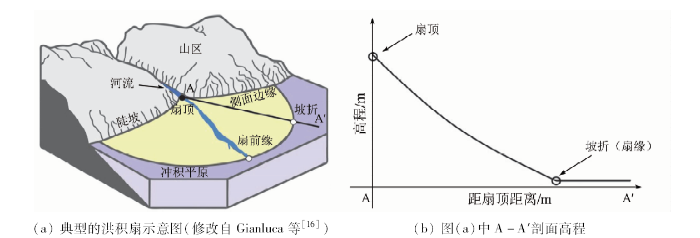
图1
山前洪积扇简图和高程纵剖面
Fig.1
Alluvial fan of predimont mountain and elevation profile
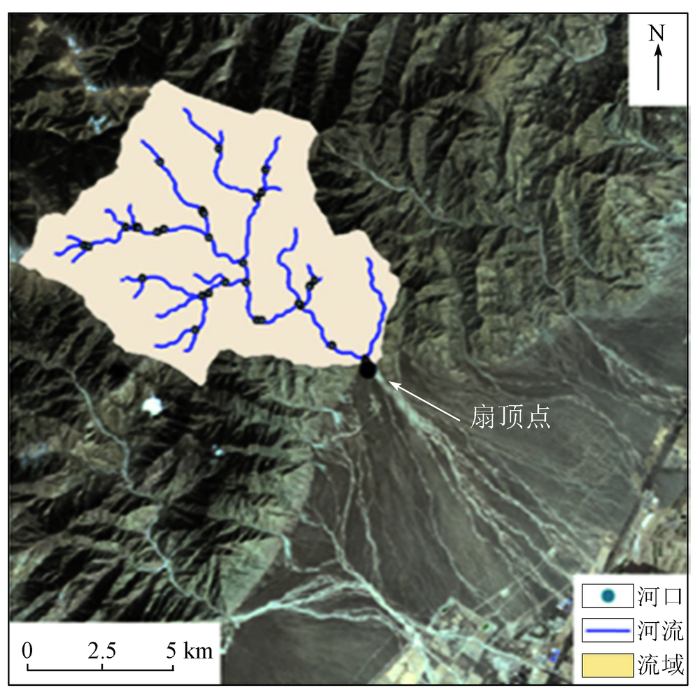
图2
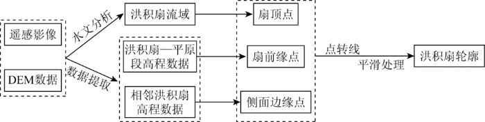
1.1 扇顶点的确定
图3
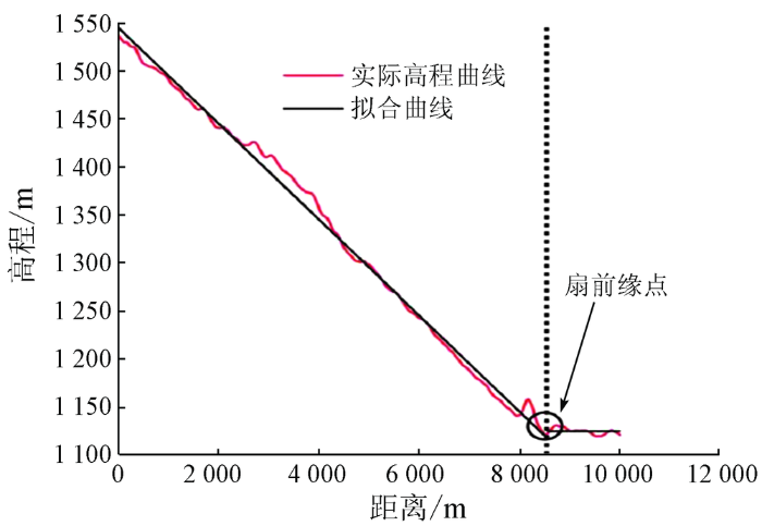
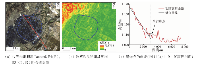
1.2 扇前缘点的确定
式中: f(x)为纵剖面高程; x为扇面某点距扇顶的水平距离; p,a,b为系数,由洪积扇的实际情况如构造、岩性和基准面等条件所决定。
式中: xn为提取的高程数据中某个采样点与扇顶点的距离; xm为高程数据最后一个采样点与扇顶点的距离。
图4
1.3 侧面边缘点的确定
本研究首先基于Landsat8遥感影像目视解译出洪积扇侧面边缘点所在的大致区域,然后基于DEM数据提取出该区域横剖面的高程数据,并建立了分段拟合函数来拟合相邻洪积扇段的高程横剖面,即
假定相邻洪积扇的扇缘为式(3)的xn点,以确定相邻洪积扇的侧面边缘点(图5)。
图5

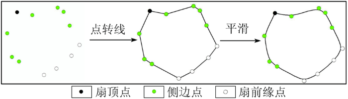
1.4 洪积扇轮廓的提取
图6
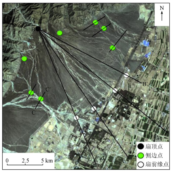
图6
扇顶点、扇前缘点和侧面边缘点的提取结果
Fig.6
Results of fan apex point,leading edge points and side edge points
图7
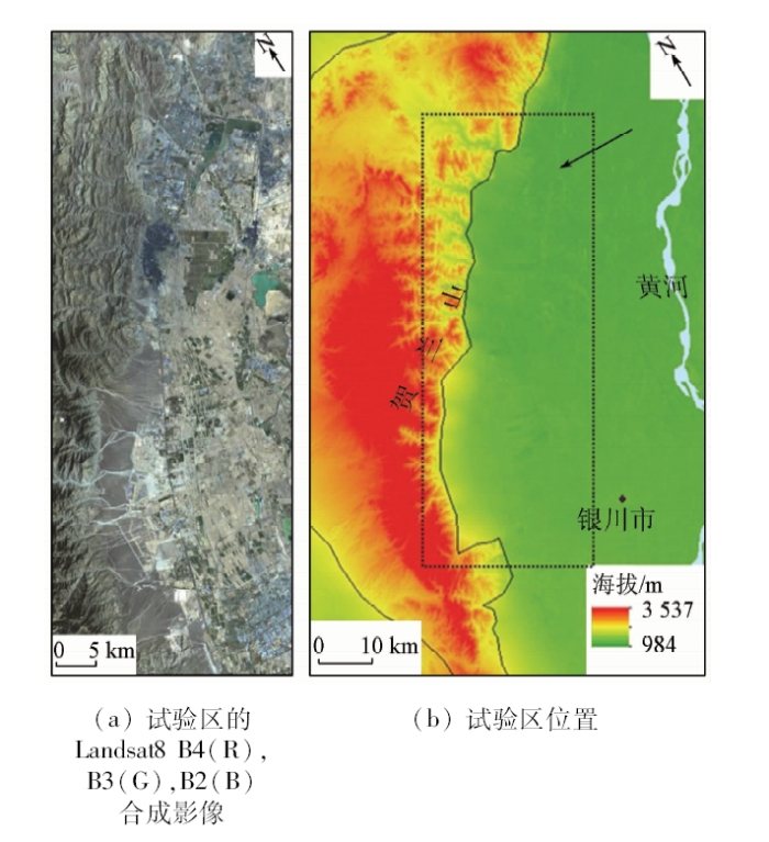
2 试验区与数据源
本研究选择洪积扇发育的贺兰山东麓作为试验区(图8)。该区位于宁夏回族自治区西北部,处于E105°75'~106°30',N39°15'~38°30'之间。区内植被稀少,季节温差大,日照充足,属季风气候区,年均降水量大约在250 mm左右,高山区达430 mm,降水主要分布在夏季[8]。同时,贺兰山自晚新生代以来遭受强烈的构造抬升,地震频发[29,30,31,32]。在高能的物理化学风化和持续的构造应力共同作用下,贺兰山发育大量山间河流,在暴雨期以洪泛堆积的方式在试验区形成了一系列的山前洪积扇[15,26]。研究数据来源于地理空间数据云平台(http: //www.gscloud.cn/),分别为30 m空间分辨率的GDEM DEM高程数据和30 m空间分辨率的Landsat8 OLI遥感数据,遥感数据获取时间为2018年3月8日,云量信息为0.36%。
图8
3 结果和讨论
3.1 结果分析
图9

图9
贺兰山东麓提取结果
(Landsat 8 B4(R),B3(G),B2(B)合成影像)
Fig.9
Extraction result at the eastern foot of Helan Mountains
表1 本研究结果与前人目视解译结果对比
Tab.1
| 扇名 | 编号 | 扇面积/km2 | 扇面宽长比 | 扇顶角/(°) | ||||||
|---|---|---|---|---|---|---|---|---|---|---|
| 本文方法 | 文献[26] | 文献[15] | 本文方法 | 文献[26] | 文献[15] | 本文方法 | 文献[26] | 文献[15] | ||
| 大武口 | 1 | 56.30 | 54.46 | — | 0.83 | 1.16 | — | 72 | 67 | — |
| 鬼头沟 | 2 | 29.73 | 28.64 | — | 0.61 | 1.06 | — | 110 | 95 | — |
| 大风沟 | 3 | 20.39 | 23.56 | — | 1.14 | 1.09 | — | 125 | 86 | — |
| 汝箕沟 | 4 | 6.94 | 9.09 | — | 0.98 | 1.11 | — | 110 | 85 | — |
| 小水沟 | 5 | 6.54 | 7.25 | — | 1.48 | 1.55 | — | 115 | 90 | — |
| 大水沟 | 6 | 9.16 | 14.07 | 29.80 | 1.02 | 1.65 | 0.65 | 105 | 131 | 103 |
| 西伏沟 | 7 | 14.80 | 27.60 | 19.04 | 0.74 | 0.69 | 0.65 | 95 | 77 | 122 |
| 插旗口 | 8 | 48.90 | 54.32 | 49.07 | 0.95 | 0.79 | 0.82 | 105 | 108 | 88 |
| 贺兰口 | 9 | 25.99 | 32.52 | 25.87 | 0.84 | 0.61 | 0.75 | 142 | 144 | 143 |
| 苏峪口 | 10 | 24.62 | 40.26 | 29.55 | 0.56 | 0.51 | 0.48 | 90 | 87 | 98 |
| 黄旗口 | 11 | 32.69 | 33.01 | 31.93 | 0.78 | 0.74 | 0.68 | 142 | 138 | 153 |
| 甘沟 | 12 | 56.89 | 61.05 | 34.22 | 0.80 | 0.59 | 0.51 | 60 | 57 | 63 |
| 山咀沟 | 13 | 14.62 | 13.02 | — | 0.97 | 1.12 | — | 180 | 131 | — |
3.2 不同方法提取的结果对比
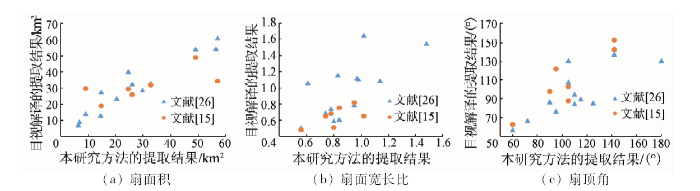
本研究方法与前人目视解译的结果比对列于表1。其中,文献[26]的结果是基于90 m空间分辨率的DEM数据提取,而文献[15]的数据为30 m空间分辨率的Landsat遥感影像和30 m空间分辨率的DEM数据。由于贺兰山东麓地区是人类活动的集中区,城市区和农业区均集中在山前一系列的洪积扇上,人类的改造作用对洪积扇表面形态影响较大,东麓北段的洪积扇(大武口、鬼头沟、大风沟、汝箕沟和小水沟)在遥感影像中模糊不清(图9),故表1中文献[15]提取的结果缺失了该部分。由表1可知,不同方法提取的洪积扇结果差异较大,即使同样是目视解译提取的结果也因人而异,这与目视解译依赖于解译人员的专业知识和主观因素的特点有关[33]。数据的类型和精度也会影响洪积扇的提取结果,这也造成了3种方式提取结果的差异[16]。
以本研究方法提取的洪积扇形态结果为横轴,前人目视解译提取的结果[15,26]为纵轴,可以得到3种提取结果的对比图(图10)。根据图10(a),不同方法提取的洪积扇面积结果大致相同,但个别结果有所差异。因为洪积扇面积与扇长度具有明显的相关性[26],说明扇面积主要受控于扇前缘,即洪积扇扇前缘离扇顶点越远,洪积扇面积越大。由于试验区洪积扇的扇前缘基本为人类活动所覆盖,对目视解译造成较大干扰,使得提取的扇前缘有所偏移,这可能是本研究的方法与目视解译的结果在个别洪积扇上有所差异的原因。而本研究方法所提取的扇前缘点是通过MATLAB程序对DEM数据空间运算求出,减少了扇前缘提取的主观性,可以使洪积扇面积提取的结果更为客观和稳定。描述洪积扇形态的宽长比和扇顶角的提取结果则呈现较大差异(图10(b)和(c)),这与相邻洪积扇彼此重叠难以区分有关。山前一系列洪积扇在向冲积平原进积的过程中,由于相互距离太近,洪积物会彼此叠置,使得洪积扇的边界模糊不清,从而影响了洪积扇侧面边缘的提取。本研究方法的侧面边缘点由相邻洪积扇的沟口高程所确定,由于洪积扇侧面边缘区复杂的叠置关系和后期人类活动作用,造成沟口被填平而难以通过Landsat8遥感影像识别出来(图9)。扇面宽长比和扇顶角受洪积扇在平原上横向延伸的影响,即扇体侧面边缘的影响。而3种方式扇侧面边缘的提取均依赖于目视解译,一定程度上均不够准确[16],故难以定量地比较扇面宽长比和扇顶角的结果,但结果有明显的正相关。然而,本研究侧面边缘点的提取是基于扇体侧面边缘区的高程拟合,提取的结果相对稳定。
图10
3.3 复杂条件的洪积扇提取
图11
4 结论
针对以往目视解译提取洪积扇的不足,本文提出了一种综合DEM和遥感影像提取洪积扇的新方法。使用该方法在试验区贺兰山东麓共计提取了13个洪积扇,与前人目视解译的结果相比,本研究方法具有以下优点:
1)充分利用了洪积扇的高程和光谱信息,实现了扇前缘、侧面边缘和扇顶的自动提取,提取的结果更加稳定和客观。
2)即使在人类活动和植被分布影响较大的复杂条件下,通过高程拟合的方式还原了原始洪积扇—冲积平原段的高程,可以有效地克服目视解译的不足,较好地提取洪积扇。
然而,本研究方法还存在不足,由于相邻洪积扇在侧面边缘区复杂的叠置关系,本研究方法对于洪积扇侧面边缘的提取仍然依赖于目视解译,导致3种结果的扇宽长比和扇顶角均有较大差异,还有待于后续的深入研究。
志谢:
感谢中山大学地球科学与工程学院王建华老师对于论文思路和撰写的指导意见!
参考文献
Alluvial and lacustrine deposits and glacial records of the upper Indus basin
[J].
地貌学与第四纪地质学的基本理论及应用
[M].
Fundamentals and applications of geomorphology and quaternary geology
[M].
龙门山北东段山前涪江第四纪冲积扇地貌演化及其构造响应
[J].
DOI:10.14027/j.cnki.cjxb.2017.01.009
URL
[本文引用: 1]

2,区域构造上为江油断层、香水-让水断层等组成的江油断裂带右旋走滑构造域。通过宇宙核素成因埋藏年龄测试技术精确地测定发源于龙门山北东段主要河流-涪江自第四纪以来发育的三期冲积扇形成年代,即早更新世冲积扇(1.84 Ma)、中更新世冲积扇(0.54 Ma)和全新世冲积扇。由于龙门山北东段-江油断裂的右旋走滑兼逆冲运动,导致涪江早更新世冲积扇扇头右旋错动约3.2 km,之后形成新的冲积扇(中更新世积扇)。随着江油断裂继续的继续活动,中更新世冲积扇扇头又被右旋错动了约0.8 km,之后形成全新世的冲积扇。涪江形成以来总共右旋错动距离约为4 km。同时,早、中更新世冲积扇褶皱隆升了约50 m,早更新世冲积扇总共褶皱隆升了约100 m。这在一定程度上反映了龙门山构造带北东段第四纪以来沉积对构造演化的响应过程。]]>
Geomorphological evolution of quaternary alluvial fans and its response to tectonic activity along the Fujiang River,northeastern Longmen Mountains
[J].
DOI:10.14027/j.cnki.cjxb.2017.01.009
URL
[本文引用: 1]
2. The alluvial fan has developed in a right-lateral strike-slip domain settings, it belongs to the Jiangyou Fault and Xiangshui-Rangshui Fault. Through the field survey, sedimentary sequence and cosmogenic nuclide burial ages data of alluvial fan, and combined with the previous research results and geological survey data, three alluvial fan's formation, distribution and tectonic activities along the Fujiang river are determined respectively. Early Pleistocene alluvial fan(1.84 Ma), Middle Pleistocene alluvial fan(0.54 Ma) and Holocene alluvial fan distributed near the northeast-southwest directions in foreland of Longmen mountains. In the middle Pleistocene, Jiangyou rupture is right-lateral strike-slip thrust fault, causing the early Pleistocene Fujiang river alluvial fan head right-lateral slip about 3.2 km, and the fan uplifted about 50 m. As Jiangyou rupture continued right-lateral strike-slip and thrust, the middle Pleistocene alluvial fan's head was right-lateral displaced about 0.8 km. During the Quaternary period, the early and middle Pleistocene alluvial fan total was right-lateral displaced about 4 km, 0.8 km, respectively. The middle Pleistocene alluvial fan uplifted about 50 m, The early Pleistocene alluvial fan total uplifted about 100 m. Sedimentary center of Fujiang river alluvial fan moved to the right downstream. Characterized by coarsening upward sedimentary sequence, gravel layer of alluvial fans asymmetrically distributed. The results show the Longmen mountains has been uplifted and the rupture right-lateral strike-slip and thrust, the Fujiang river alluvial fans expanded as a correspondence to the tectonic activities.]]>
Development of a streamflow-dominated alluvial-fan system in the southwestern margin of Gyeongsang basin(Lower Cretaceous):Implications for initial basin-fill history
[J].DOI:10.1007/s12303-018-0073-5 URL [本文引用: 1]
Late Quaternary slip rates for the southern Elsinore fault in the Coyote Mountains,southern California from analysis of alluvial fan landforms and clast provenance,soils and U-series ages of pedogenic carbonate
[J].DOI:10.1016/j.geomorph.2018.02.024 URL [本文引用: 1]
Sedimentology of the debris-flow-dominated Warm Spring Canyon alluvial fan,Death Valley,California
[J].DOI:10.1046/j.1365-3091.1999.00260.x URL [本文引用: 1]
贺兰山东麓冲积扇发育特征
[J].
The alluvial fans along the eastern foot of Helan Mountain
[J].
Processes and forms of alluvial fans
[M].
Chadwick.Geomorphic processes and remote sensing signatures of alluvial fans in the Kun Lun Mountains,China
[J].
玛纳斯河山麓冲积扇演变遥感研究
[J].基于地质过程,特别是沉积地质过程的理论和方法,通过对航空相片和遥感影像的解译,结合野外考察和地貌与沉积物分析,研究玛纳斯河山麓冲积扇的演变过程,并对其形成和演变原因进行探讨.晚第四纪以来,玛纳斯河山麓冲积扇从第二排山麓到下游冲积平原,可划分为四期规模较大和三期规模较小的冲积扇;玛纳斯河山麓冲积扇的形成演变受气候、构造或气候-构造耦合作用的共同影响,具有多成因性和多层次性.
Evolution of alluvial fans at range-front of Tian Mountains in Manas River valley based on remote sensing technology
[J].
龙门山断裂带北东段活动断裂的遥感影像解译及构造活动性分析
[J].
Remote sensing image interpretation and tectonic activity study of the active faults along the northeastern segment of the Longmenshan fault
[J].
祁连山北麓洪积扇坡度特征及其控制因素分析
[D].
Characteristics and controlling factors of alluvial fan slopes in the northern piedmont of the Qilian Shan
[D].
侯马盆地冲积扇及其流域地貌发育规律
[J].
DOI:10.11821/xb200603002
URL
[本文引用: 1]
根据从DEM数据中提取的侯马盆地冲积扇及其流域的多项地貌指标,分析了各地貌指标的空间分布规律,并通过地貌指标的空间分布曲线与山前地形高程曲线形态的对比以及地貌指标相关性分析来揭示冲积扇及其流域地貌的发育规律。结果表明,在侯马盆地相对隆起部位的冲积扇及其流域的地貌指标与在盆地凹陷部位的冲积扇及其流域的地貌指标有较大差异;流域地貌指标的空间分布受到盆地边界断层构造活动性的影响;冲积扇的发育主要受到流域规模、山前构造活动以及盆地基准面等多种因素共同的影响;流域内岩性的差异不是造成研究区域内冲积扇地貌差异的主要因素。
Development of alluvial fans and their catchments in Houma basin
[J].
DOI:10.11821/xb200603002
URL
[本文引用: 1]
We collected indexes of alluvial fans and their drainage basins from DEM data, and analyzed distribution of these indexes. By comparison of distribution curves of these indexes with elevation distribution curve of piedmont landforms, we did some research on the developments of alluvial fans and their drainage basins. As a result, we find that the alluvial fans and their drainage basins in the uplift region of Houma basin differ greatly from those in the sunken region; distributions of drainage basin indexes are mainly influenced by tectonic activity of boundary fault; alluvial fans are influenced by factors of drainage basin, tectonic movement of boundary fault and base level together; and lithological difference between rocks and underlying drainage basins is not the main factor leading to difference in alluvial fans in the study area.
基于GIS技术研究贺兰山、罗山洪积扇特征与山脉抬升关系
[J].
The relationship between alluvial fans and mountain uplift in Helanshan and Luoshan Mountains in northwestern China based on GIS technique
[J].
Delineation of alluvial fans from digital elevation models with a GIS algorithm for the geomorphological mapping of the Earth and Mars
[J].DOI:10.1016/j.geomorph.2016.08.010 URL [本文引用: 5]
Automatic extraction of alluvial fans from ASTER L1 satellite data and a digital elevation model using object-oriented image
[C]//
Automated alluvial fan discrimination, quaternary fault identification,and the distribution of tectonically reactivated crust in the Gobi Altai region,southern Mongolia
[J].DOI:10.1080/01431160802220227 URL [本文引用: 2]
利用ETM+影像自动提取河流冲积扇的方法
[J].
Automatic extraction method of alluvial fan based on ETM+ images
[J].
Sedimentologic and geomorphic variations in storm generated alluvial fans,Howgill Fells,northwest England
[J].DOI:10.1130/0016-7606(1987)98<182:SAGVIS>2.0.CO;2 URL [本文引用: 2]
Slope of alluvial fans in humid regions of Japan,Taiwan and the Philippines
[J].DOI:10.1016/j.geomorph.2005.04.006 URL [本文引用: 2]
Alluvial fans:Geomorphology,sedimentology,dynamics-introduction,a review of alluvial fan research
[J].DOI:10.1144/GSL.SP.2005.251.01.01 URL [本文引用: 2]
Laboratory alluvial fans in one dimension
[J].
Modelling alluvial fan morphology
[J].
中国北方地区冲积扇地貌发育特征与影响因素分析
[D].
Geomorphology and affecting factors analysis of alluvial fans in north China
[D].
贺兰山晚新生代隆升的剥露特征及其隆升模式
[J].
The feature and pattern of late Cenozoic uplift and exhumation of the Helan Shan
[J].
Mesozoic contractional deformation in the middle of the Asian tectonic collage:The intraplate Western Ordos fold-thrust belt,China
[J].DOI:10.1016/S0012-821X(02)01026-9 URL [本文引用: 1]
贺兰山东麓新构造运动特征初探
[J].
An approach to the characteristics of neotectonic movement in the eastern foot of Helan Mountains
[J].
遥感影像解译的研究现状和发展趋势
[J].
The present research condition and development trend of remotely sensed imagery interpretation
[J].
The alluvial fan environment
[J].
Analysis of relationships among alluvial-fan area,source basin area,basin slope,and sediment yield
[J].
