植被覆盖地表土壤水分遥感反演
2
2010
... 土壤水分在农业用水管理、农作物估产、旱情监测和精准灌溉中起着非常重要的作用,因此快速精准地监测土壤水分空间变化具有重要意义[1,2,3,4,5].通过探针法或重量法来测定土壤水分的传统方法,虽然精度高,但不能满足大范围土壤水分监测的需求.遥感技术具有覆盖广、时效强的特点,是目前大尺度土壤水分监测的主要手段[2,6-8]. ...
... 孔金玲等[11]利用TM数据分别选取NDVI和NDWI指数对植被冠层含水量进行反演,通过水云模型消除植被层对土壤后向散射系数的影响,联合RADARSAT-2数据反演了旱区不同植被覆盖下地表土壤水分,结果表明NDVI适合去除该地表条件下稀疏植被覆盖产生的影响; 韩玲等[47]采用多种植被指数反演植被含水量,发现将RVI引入水云模型,剔除植被层对雷达后向散射系数影响的效果更好,VV极化比VH极化更适合于低矮植被覆盖地表的土壤水分反演; 马腾等[45]采用不同的植被指数分别与冠层含水量建立关系,联合水云模型去除植被影响,结果表明不同植被覆盖率下存在各自最优的植被指数,土壤水分反演中,不同植被覆盖率地表应采用不同的植被指数; Yadav等[48]综合Landsat8数据和Sentinel-1A数据,将植被覆盖度与水云模型结合,进行土壤水分的反演; 周鹏等[1]使用Landsat5光学遥感数据获取改进型归一化差分水分指数(normalized difference moisture index,NDMI),建立NDMI与冠层含水量间的关系,通过水云模型消除植被覆盖影响,实现了土壤水分的反演; Park等[49]通过研究理论散射模型与水云模型植被参数间的关系,对水云模型原始表达式和改进表达式进行了评价,指出冠层含水量为水云模型中最佳植被描述符; Wang等[50]利用多时序MODIS数据提取NDVI,增强植被指数(enhanced vegetation index,EVI),LAI和光合有效辐射分量(fraction of photosynthetically active radiation,FPAR)参数,并进行不同组合代入水云模型消除植被影响,结果表明使用NDVI和LAI组合时效果最好. ...
Soil moisture retrieval over irrigated grassland using X-band SAR data
3
2016
... 土壤水分在农业用水管理、农作物估产、旱情监测和精准灌溉中起着非常重要的作用,因此快速精准地监测土壤水分空间变化具有重要意义[1,2,3,4,5].通过探针法或重量法来测定土壤水分的传统方法,虽然精度高,但不能满足大范围土壤水分监测的需求.遥感技术具有覆盖广、时效强的特点,是目前大尺度土壤水分监测的主要手段[2,6-8]. ...
... [2,6-8]. ...
... 近年来随着机器学习[57]在诸多领域应用中取得了突破性进展,BP神经网络[58,59]、随机森林[48]、深度学习[60]等已经被应用到土壤水分的遥感反演中,从多源遥感数据中挖掘更丰富的隐含信息[61],表现出了强大的发展潜力[62].余凡等[58]提出了一种基于GA-BP神经网络优化的光学和SAR数据协同反演土壤水分的方法,与传统模型方法进行对比发现,利用神经网络进行植被覆盖区的土壤水分反演是可靠的; Notarnicola等[63]基于人工神经网络(artificial neural networks,ANN)反演土壤水分,发现随着输入ANN特征量的增加,土壤水分反演精度可得到逐步提高; Kolassa等[64]使用神经网络方法反演全球土壤水分,结果表明神经网络方法对于短期土壤水分变化比较敏感,在植被密集区反演效果更好; 姜红等[60]分别利用光学数据计算改进的温度植被干旱指数(modified temperature vegetation drought index,MTVDI)和SAR土壤后向散射系数 作为支持向量机(support vector machine,SVM)回归算法的输入特征量,结果显示两者共同输入时比任何单一参数时效果都好; Hajj等[2]结合水云模型和神经网络算法,利用X波段的雷达数据和光学影像实现了灌溉草地区域的土壤水分反演. ...
Soil moisture mapping at regional scales using microwave radiometry:The southern great plains hydrology experiment
1
1999
... 土壤水分在农业用水管理、农作物估产、旱情监测和精准灌溉中起着非常重要的作用,因此快速精准地监测土壤水分空间变化具有重要意义[1,2,3,4,5].通过探针法或重量法来测定土壤水分的传统方法,虽然精度高,但不能满足大范围土壤水分监测的需求.遥感技术具有覆盖广、时效强的特点,是目前大尺度土壤水分监测的主要手段[2,6-8]. ...
Soil moisture estimation using combined multifrequency SAR data:A comparison between two inversion models using simulation
1
2000
... 土壤水分在农业用水管理、农作物估产、旱情监测和精准灌溉中起着非常重要的作用,因此快速精准地监测土壤水分空间变化具有重要意义[1,2,3,4,5].通过探针法或重量法来测定土壤水分的传统方法,虽然精度高,但不能满足大范围土壤水分监测的需求.遥感技术具有覆盖广、时效强的特点,是目前大尺度土壤水分监测的主要手段[2,6-8]. ...
Soil moisture retrievals using L-band radiometry from variable angular ground-based and airborne observations
1
2020
... 土壤水分在农业用水管理、农作物估产、旱情监测和精准灌溉中起着非常重要的作用,因此快速精准地监测土壤水分空间变化具有重要意义[1,2,3,4,5].通过探针法或重量法来测定土壤水分的传统方法,虽然精度高,但不能满足大范围土壤水分监测的需求.遥感技术具有覆盖广、时效强的特点,是目前大尺度土壤水分监测的主要手段[2,6-8]. ...
A semi-empirical backscattering model at L-band and C-band for a soybean canopy with soil moisture inversion
2
2001
... 土壤水分在农业用水管理、农作物估产、旱情监测和精准灌溉中起着非常重要的作用,因此快速精准地监测土壤水分空间变化具有重要意义[1,2,3,4,5].通过探针法或重量法来测定土壤水分的传统方法,虽然精度高,但不能满足大范围土壤水分监测的需求.遥感技术具有覆盖广、时效强的特点,是目前大尺度土壤水分监测的主要手段[2,6-8]. ...
... De Roo等[6]基于MIMICS模型的模拟确定冠层植被指数与冠层的消光系数、散射系数的关系,实现了MIMICS模型的参数化,利用L波段与C波段联合Oh半经验模型反演了大豆覆盖地表农田的土壤水分; 鲍艳松等[52]利用MIMICS模型分析了植被微波散射与NDVI间的关系,建立了反演土壤水分的半经验模型; 雷志斌等[53]联合高分三号和Landsat8遥感数据,首先利用PROSAIL模型和实测植被数据进行冠层最优植被指数的筛选后构建植被含水量反演模型,然后利用简化的MIMICS模型进行土壤水分反演; 余凡等[10]联合PROSAIL模型和MIMICS模型,提出MIMICS模型的参数化方法,通过引入植被均方根高度对由冠层重叠造成的雷达阴影进行校正,对甘肃张掖地区农业灌溉区进行了土壤水分估算. ...
On the soil roughness parameterization problem in soil moisture retrieval of bare surfaces from synthetic aperture Radar
0
2008
On the derivation of soil surface roughness from multi parametric PolSAR data and its potential for hydrological modeling
1
2009
... 土壤水分在农业用水管理、农作物估产、旱情监测和精准灌溉中起着非常重要的作用,因此快速精准地监测土壤水分空间变化具有重要意义[1,2,3,4,5].通过探针法或重量法来测定土壤水分的传统方法,虽然精度高,但不能满足大范围土壤水分监测的需求.遥感技术具有覆盖广、时效强的特点,是目前大尺度土壤水分监测的主要手段[2,6-8]. ...
基于改进热惯量模型的表层土壤水反演研究
1
2017
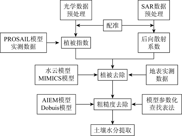
... 光学遥感能提供高光谱分辨率、高空间分辨率的数据,基于光学遥感的土壤水分监测技术主要适用于裸露地表,在植被覆盖区由于无法直接获取土壤的光谱信息,导致其土壤水分监测能力有限.热红外遥感可基于地表温度的变化来估算土壤水分,在低植被覆盖区,热惯量法[9]是最常用的反演方法,因为土壤热惯量随着土壤水分含量的增加而增大,导致地表昼夜温差降低; 在中高植被覆盖区,温度植被干旱指数法(temperature vegetation dryness index,TVDI)是联合光学与热红外遥感进行土壤水分反演或土壤干旱程度监测的常用方法.光学和热红外遥感容易受到云、雾等大气条件的影响,土壤水分监测的连续性难以得到保证[10,11,12,13].合成孔径雷达(synthetic aperture Radar,SAR)对大气的穿透能力强,具有在各种气象条件下的全天候对地观测能力,且SAR回波强度对土壤水分变化有较高的灵敏性.目前基于星载SAR后向散射系数与土壤水分的相关性[14],进行区域土壤水分反演的遥感技术方法已得到普遍应用. ...
基于改进热惯量模型的表层土壤水反演研究
1
2017
... 光学遥感能提供高光谱分辨率、高空间分辨率的数据,基于光学遥感的土壤水分监测技术主要适用于裸露地表,在植被覆盖区由于无法直接获取土壤的光谱信息,导致其土壤水分监测能力有限.热红外遥感可基于地表温度的变化来估算土壤水分,在低植被覆盖区,热惯量法[9]是最常用的反演方法,因为土壤热惯量随着土壤水分含量的增加而增大,导致地表昼夜温差降低; 在中高植被覆盖区,温度植被干旱指数法(temperature vegetation dryness index,TVDI)是联合光学与热红外遥感进行土壤水分反演或土壤干旱程度监测的常用方法.光学和热红外遥感容易受到云、雾等大气条件的影响,土壤水分监测的连续性难以得到保证[10,11,12,13].合成孔径雷达(synthetic aperture Radar,SAR)对大气的穿透能力强,具有在各种气象条件下的全天候对地观测能力,且SAR回波强度对土壤水分变化有较高的灵敏性.目前基于星载SAR后向散射系数与土壤水分的相关性[14],进行区域土壤水分反演的遥感技术方法已得到普遍应用. ...
ASAR和TM数据协同反演植被覆盖地表土壤水分的新方法
2
2011
... 光学遥感能提供高光谱分辨率、高空间分辨率的数据,基于光学遥感的土壤水分监测技术主要适用于裸露地表,在植被覆盖区由于无法直接获取土壤的光谱信息,导致其土壤水分监测能力有限.热红外遥感可基于地表温度的变化来估算土壤水分,在低植被覆盖区,热惯量法[9]是最常用的反演方法,因为土壤热惯量随着土壤水分含量的增加而增大,导致地表昼夜温差降低; 在中高植被覆盖区,温度植被干旱指数法(temperature vegetation dryness index,TVDI)是联合光学与热红外遥感进行土壤水分反演或土壤干旱程度监测的常用方法.光学和热红外遥感容易受到云、雾等大气条件的影响,土壤水分监测的连续性难以得到保证[10,11,12,13].合成孔径雷达(synthetic aperture Radar,SAR)对大气的穿透能力强,具有在各种气象条件下的全天候对地观测能力,且SAR回波强度对土壤水分变化有较高的灵敏性.目前基于星载SAR后向散射系数与土壤水分的相关性[14],进行区域土壤水分反演的遥感技术方法已得到普遍应用. ...
... De Roo等[6]基于MIMICS模型的模拟确定冠层植被指数与冠层的消光系数、散射系数的关系,实现了MIMICS模型的参数化,利用L波段与C波段联合Oh半经验模型反演了大豆覆盖地表农田的土壤水分; 鲍艳松等[52]利用MIMICS模型分析了植被微波散射与NDVI间的关系,建立了反演土壤水分的半经验模型; 雷志斌等[53]联合高分三号和Landsat8遥感数据,首先利用PROSAIL模型和实测植被数据进行冠层最优植被指数的筛选后构建植被含水量反演模型,然后利用简化的MIMICS模型进行土壤水分反演; 余凡等[10]联合PROSAIL模型和MIMICS模型,提出MIMICS模型的参数化方法,通过引入植被均方根高度对由冠层重叠造成的雷达阴影进行校正,对甘肃张掖地区农业灌溉区进行了土壤水分估算. ...
微波与光学遥感协同反演旱区地表土壤水分研究
2
2016
... 光学遥感能提供高光谱分辨率、高空间分辨率的数据,基于光学遥感的土壤水分监测技术主要适用于裸露地表,在植被覆盖区由于无法直接获取土壤的光谱信息,导致其土壤水分监测能力有限.热红外遥感可基于地表温度的变化来估算土壤水分,在低植被覆盖区,热惯量法[9]是最常用的反演方法,因为土壤热惯量随着土壤水分含量的增加而增大,导致地表昼夜温差降低; 在中高植被覆盖区,温度植被干旱指数法(temperature vegetation dryness index,TVDI)是联合光学与热红外遥感进行土壤水分反演或土壤干旱程度监测的常用方法.光学和热红外遥感容易受到云、雾等大气条件的影响,土壤水分监测的连续性难以得到保证[10,11,12,13].合成孔径雷达(synthetic aperture Radar,SAR)对大气的穿透能力强,具有在各种气象条件下的全天候对地观测能力,且SAR回波强度对土壤水分变化有较高的灵敏性.目前基于星载SAR后向散射系数与土壤水分的相关性[14],进行区域土壤水分反演的遥感技术方法已得到普遍应用. ...
... 孔金玲等[11]利用TM数据分别选取NDVI和NDWI指数对植被冠层含水量进行反演,通过水云模型消除植被层对土壤后向散射系数的影响,联合RADARSAT-2数据反演了旱区不同植被覆盖下地表土壤水分,结果表明NDVI适合去除该地表条件下稀疏植被覆盖产生的影响; 韩玲等[47]采用多种植被指数反演植被含水量,发现将RVI引入水云模型,剔除植被层对雷达后向散射系数影响的效果更好,VV极化比VH极化更适合于低矮植被覆盖地表的土壤水分反演; 马腾等[45]采用不同的植被指数分别与冠层含水量建立关系,联合水云模型去除植被影响,结果表明不同植被覆盖率下存在各自最优的植被指数,土壤水分反演中,不同植被覆盖率地表应采用不同的植被指数; Yadav等[48]综合Landsat8数据和Sentinel-1A数据,将植被覆盖度与水云模型结合,进行土壤水分的反演; 周鹏等[1]使用Landsat5光学遥感数据获取改进型归一化差分水分指数(normalized difference moisture index,NDMI),建立NDMI与冠层含水量间的关系,通过水云模型消除植被覆盖影响,实现了土壤水分的反演; Park等[49]通过研究理论散射模型与水云模型植被参数间的关系,对水云模型原始表达式和改进表达式进行了评价,指出冠层含水量为水云模型中最佳植被描述符; Wang等[50]利用多时序MODIS数据提取NDVI,增强植被指数(enhanced vegetation index,EVI),LAI和光合有效辐射分量(fraction of photosynthetically active radiation,FPAR)参数,并进行不同组合代入水云模型消除植被影响,结果表明使用NDVI和LAI组合时效果最好. ...
利用SAR影像与多光谱数据反演广域土壤湿度
1
2020
... 光学遥感能提供高光谱分辨率、高空间分辨率的数据,基于光学遥感的土壤水分监测技术主要适用于裸露地表,在植被覆盖区由于无法直接获取土壤的光谱信息,导致其土壤水分监测能力有限.热红外遥感可基于地表温度的变化来估算土壤水分,在低植被覆盖区,热惯量法[9]是最常用的反演方法,因为土壤热惯量随着土壤水分含量的增加而增大,导致地表昼夜温差降低; 在中高植被覆盖区,温度植被干旱指数法(temperature vegetation dryness index,TVDI)是联合光学与热红外遥感进行土壤水分反演或土壤干旱程度监测的常用方法.光学和热红外遥感容易受到云、雾等大气条件的影响,土壤水分监测的连续性难以得到保证[10,11,12,13].合成孔径雷达(synthetic aperture Radar,SAR)对大气的穿透能力强,具有在各种气象条件下的全天候对地观测能力,且SAR回波强度对土壤水分变化有较高的灵敏性.目前基于星载SAR后向散射系数与土壤水分的相关性[14],进行区域土壤水分反演的遥感技术方法已得到普遍应用. ...
光学与微波数据协同反演农田区土壤水分
1
2014
... 光学遥感能提供高光谱分辨率、高空间分辨率的数据,基于光学遥感的土壤水分监测技术主要适用于裸露地表,在植被覆盖区由于无法直接获取土壤的光谱信息,导致其土壤水分监测能力有限.热红外遥感可基于地表温度的变化来估算土壤水分,在低植被覆盖区,热惯量法[9]是最常用的反演方法,因为土壤热惯量随着土壤水分含量的增加而增大,导致地表昼夜温差降低; 在中高植被覆盖区,温度植被干旱指数法(temperature vegetation dryness index,TVDI)是联合光学与热红外遥感进行土壤水分反演或土壤干旱程度监测的常用方法.光学和热红外遥感容易受到云、雾等大气条件的影响,土壤水分监测的连续性难以得到保证[10,11,12,13].合成孔径雷达(synthetic aperture Radar,SAR)对大气的穿透能力强,具有在各种气象条件下的全天候对地观测能力,且SAR回波强度对土壤水分变化有较高的灵敏性.目前基于星载SAR后向散射系数与土壤水分的相关性[14],进行区域土壤水分反演的遥感技术方法已得到普遍应用. ...
Soil moisture mapping using Sentinel-1 images:Algorithm and preliminary validation
1
2013
... 光学遥感能提供高光谱分辨率、高空间分辨率的数据,基于光学遥感的土壤水分监测技术主要适用于裸露地表,在植被覆盖区由于无法直接获取土壤的光谱信息,导致其土壤水分监测能力有限.热红外遥感可基于地表温度的变化来估算土壤水分,在低植被覆盖区,热惯量法[9]是最常用的反演方法,因为土壤热惯量随着土壤水分含量的增加而增大,导致地表昼夜温差降低; 在中高植被覆盖区,温度植被干旱指数法(temperature vegetation dryness index,TVDI)是联合光学与热红外遥感进行土壤水分反演或土壤干旱程度监测的常用方法.光学和热红外遥感容易受到云、雾等大气条件的影响,土壤水分监测的连续性难以得到保证[10,11,12,13].合成孔径雷达(synthetic aperture Radar,SAR)对大气的穿透能力强,具有在各种气象条件下的全天候对地观测能力,且SAR回波强度对土壤水分变化有较高的灵敏性.目前基于星载SAR后向散射系数与土壤水分的相关性[14],进行区域土壤水分反演的遥感技术方法已得到普遍应用. ...
The capability of integrating optical and microwave data for detecting soil moisture in an oasis region
1
2020
... 在植被覆盖区,由于植被层对微波的强烈散射作用,造成SAR后向散射系数对土壤水分变化的敏感性下降,降低了土壤水分的反演精度[15,16,17,18,19].光学遥感可有效提取植被冠层的信息,因此光学与SAR遥感协同反演土壤水分能够结合二者优点,提高土壤水分的反演精度[20].本文简要总结了光学与SAR遥感协同反演土壤水分研究中相关模型与算法的进展情况和存在的主要问题,并对农田区土壤水分反演研究的前景进行展望. ...
利用多时相Sentinel-1 SAR数据反演农田地表土壤水分
1
2016
... 在植被覆盖区,由于植被层对微波的强烈散射作用,造成SAR后向散射系数对土壤水分变化的敏感性下降,降低了土壤水分的反演精度[15,16,17,18,19].光学遥感可有效提取植被冠层的信息,因此光学与SAR遥感协同反演土壤水分能够结合二者优点,提高土壤水分的反演精度[20].本文简要总结了光学与SAR遥感协同反演土壤水分研究中相关模型与算法的进展情况和存在的主要问题,并对农田区土壤水分反演研究的前景进行展望. ...
利用多时相Sentinel-1 SAR数据反演农田地表土壤水分
1
2016
... 在植被覆盖区,由于植被层对微波的强烈散射作用,造成SAR后向散射系数对土壤水分变化的敏感性下降,降低了土壤水分的反演精度[15,16,17,18,19].光学遥感可有效提取植被冠层的信息,因此光学与SAR遥感协同反演土壤水分能够结合二者优点,提高土壤水分的反演精度[20].本文简要总结了光学与SAR遥感协同反演土壤水分研究中相关模型与算法的进展情况和存在的主要问题,并对农田区土壤水分反演研究的前景进行展望. ...
基于Sentinel多源数据的晋南农田地表土壤水分反演
1
2020
... 在植被覆盖区,由于植被层对微波的强烈散射作用,造成SAR后向散射系数对土壤水分变化的敏感性下降,降低了土壤水分的反演精度[15,16,17,18,19].光学遥感可有效提取植被冠层的信息,因此光学与SAR遥感协同反演土壤水分能够结合二者优点,提高土壤水分的反演精度[20].本文简要总结了光学与SAR遥感协同反演土壤水分研究中相关模型与算法的进展情况和存在的主要问题,并对农田区土壤水分反演研究的前景进行展望. ...
基于Sentinel多源数据的晋南农田地表土壤水分反演
1
2020
... 在植被覆盖区,由于植被层对微波的强烈散射作用,造成SAR后向散射系数对土壤水分变化的敏感性下降,降低了土壤水分的反演精度[15,16,17,18,19].光学遥感可有效提取植被冠层的信息,因此光学与SAR遥感协同反演土壤水分能够结合二者优点,提高土壤水分的反演精度[20].本文简要总结了光学与SAR遥感协同反演土壤水分研究中相关模型与算法的进展情况和存在的主要问题,并对农田区土壤水分反演研究的前景进行展望. ...
干旱区土壤水分微波遥感反演算法综述
1
2011
... 在植被覆盖区,由于植被层对微波的强烈散射作用,造成SAR后向散射系数对土壤水分变化的敏感性下降,降低了土壤水分的反演精度[15,16,17,18,19].光学遥感可有效提取植被冠层的信息,因此光学与SAR遥感协同反演土壤水分能够结合二者优点,提高土壤水分的反演精度[20].本文简要总结了光学与SAR遥感协同反演土壤水分研究中相关模型与算法的进展情况和存在的主要问题,并对农田区土壤水分反演研究的前景进行展望. ...
干旱区土壤水分微波遥感反演算法综述
1
2011
... 在植被覆盖区,由于植被层对微波的强烈散射作用,造成SAR后向散射系数对土壤水分变化的敏感性下降,降低了土壤水分的反演精度[15,16,17,18,19].光学遥感可有效提取植被冠层的信息,因此光学与SAR遥感协同反演土壤水分能够结合二者优点,提高土壤水分的反演精度[20].本文简要总结了光学与SAR遥感协同反演土壤水分研究中相关模型与算法的进展情况和存在的主要问题,并对农田区土壤水分反演研究的前景进行展望. ...
利用多时相ASAR数据反演黑河流域中游地表土壤水分
1
2009
... 在植被覆盖区,由于植被层对微波的强烈散射作用,造成SAR后向散射系数对土壤水分变化的敏感性下降,降低了土壤水分的反演精度[15,16,17,18,19].光学遥感可有效提取植被冠层的信息,因此光学与SAR遥感协同反演土壤水分能够结合二者优点,提高土壤水分的反演精度[20].本文简要总结了光学与SAR遥感协同反演土壤水分研究中相关模型与算法的进展情况和存在的主要问题,并对农田区土壤水分反演研究的前景进行展望. ...
利用多时相ASAR数据反演黑河流域中游地表土壤水分
1
2009
... 在植被覆盖区,由于植被层对微波的强烈散射作用,造成SAR后向散射系数对土壤水分变化的敏感性下降,降低了土壤水分的反演精度[15,16,17,18,19].光学遥感可有效提取植被冠层的信息,因此光学与SAR遥感协同反演土壤水分能够结合二者优点,提高土壤水分的反演精度[20].本文简要总结了光学与SAR遥感协同反演土壤水分研究中相关模型与算法的进展情况和存在的主要问题,并对农田区土壤水分反演研究的前景进行展望. ...
2019年中国陆表定量遥感发展综述
1
2020
... 在植被覆盖区,由于植被层对微波的强烈散射作用,造成SAR后向散射系数对土壤水分变化的敏感性下降,降低了土壤水分的反演精度[15,16,17,18,19].光学遥感可有效提取植被冠层的信息,因此光学与SAR遥感协同反演土壤水分能够结合二者优点,提高土壤水分的反演精度[20].本文简要总结了光学与SAR遥感协同反演土壤水分研究中相关模型与算法的进展情况和存在的主要问题,并对农田区土壤水分反演研究的前景进行展望. ...
2019年中国陆表定量遥感发展综述
1
2020
... 在植被覆盖区,由于植被层对微波的强烈散射作用,造成SAR后向散射系数对土壤水分变化的敏感性下降,降低了土壤水分的反演精度[15,16,17,18,19].光学遥感可有效提取植被冠层的信息,因此光学与SAR遥感协同反演土壤水分能够结合二者优点,提高土壤水分的反演精度[20].本文简要总结了光学与SAR遥感协同反演土壤水分研究中相关模型与算法的进展情况和存在的主要问题,并对农田区土壤水分反演研究的前景进行展望. ...
Simultaneous retrieval of global scale vegetation optical depth,surface roughness,and soil moisture using X-band AMSR-E observations
1
2019
... 大部分陆地地表均有植被覆盖,植被的存在使得利用微波遥感反演土壤水分的难度大大增加.在植被覆盖区,微波遥感会受到地表粗糙度和植被的双重影响,因此基于微波遥感技术的土壤水分反演研究中如何去除土壤粗糙度和植被的影响尤为重要.国内外学者研究发现,不同波段对于土壤水分和冠层参数的响应度不同[21],每个波段都有自身敏感的对象,比如,光学遥感数据对植被信息较敏感,而SAR遥感数据对土壤水分信息更敏感[22],因此,将光学遥感与SAR两者相结合来消除植被层对土壤水分反演的影响受到了学者们的普遍关注.目前,综合运用光学和SAR遥感技术进行土壤水分的监测研究,已取得了一系列突破,发展了众多土壤水分反演的相关算法和模型. ...
A bayesian change detection approach for retrieval of soil moisture variations under different roughness conditions
1
2013
... 大部分陆地地表均有植被覆盖,植被的存在使得利用微波遥感反演土壤水分的难度大大增加.在植被覆盖区,微波遥感会受到地表粗糙度和植被的双重影响,因此基于微波遥感技术的土壤水分反演研究中如何去除土壤粗糙度和植被的影响尤为重要.国内外学者研究发现,不同波段对于土壤水分和冠层参数的响应度不同[21],每个波段都有自身敏感的对象,比如,光学遥感数据对植被信息较敏感,而SAR遥感数据对土壤水分信息更敏感[22],因此,将光学遥感与SAR两者相结合来消除植被层对土壤水分反演的影响受到了学者们的普遍关注.目前,综合运用光学和SAR遥感技术进行土壤水分的监测研究,已取得了一系列突破,发展了众多土壤水分反演的相关算法和模型. ...
A comprehensive analysis of rough soil surface scattering and emission predicted by AIEM with comparison to numerical simulations and experimental measurements
1
2017
... 近年来,基于电磁波传输理论的地表微波辐射理论模型取得了显著的发展,如积分方程模型(integrated equation model,IEM)和其改进模型(advanced integral equation model,AIEM).IEM模型是使用较广泛的一个面散射模型,具有较广的粗糙度适用范围[23],对于裸露地表,SAR后向散射系数 可表达为: ...
A transition model for the reflection coefficient in surface scattering
1
2001
... 由于IEM模型对不同粗糙度条件下的地表微波散射模拟精度存在差异.Wu等[24]和Chen等[25]通过修正菲涅尔反射系数的计算方法和粗糙度功率谱函数,使模型模拟精度得到进一步提高,改进后模型被称为AIEM模型.相关研究表明,相比IEM模型,AIEM模型不仅有更宽的粗糙度适用范围,而且具有更强的模拟宽波段和大角度观测数据的能力[26,27,28]. ...
Emission of rough surfaces calculated by the integral equation method with comparison to three-dimensional moment method simulations
1
2003
... 由于IEM模型对不同粗糙度条件下的地表微波散射模拟精度存在差异.Wu等[24]和Chen等[25]通过修正菲涅尔反射系数的计算方法和粗糙度功率谱函数,使模型模拟精度得到进一步提高,改进后模型被称为AIEM模型.相关研究表明,相比IEM模型,AIEM模型不仅有更宽的粗糙度适用范围,而且具有更强的模拟宽波段和大角度观测数据的能力[26,27,28]. ...
A reappraisal of the validity of the IEM model for backscattering from rough surfaces
1
2004
... 由于IEM模型对不同粗糙度条件下的地表微波散射模拟精度存在差异.Wu等[24]和Chen等[25]通过修正菲涅尔反射系数的计算方法和粗糙度功率谱函数,使模型模拟精度得到进一步提高,改进后模型被称为AIEM模型.相关研究表明,相比IEM模型,AIEM模型不仅有更宽的粗糙度适用范围,而且具有更强的模拟宽波段和大角度观测数据的能力[26,27,28]. ...
Depolarized backscattering of rough surface by AIEM model
1
2017
... 由于IEM模型对不同粗糙度条件下的地表微波散射模拟精度存在差异.Wu等[24]和Chen等[25]通过修正菲涅尔反射系数的计算方法和粗糙度功率谱函数,使模型模拟精度得到进一步提高,改进后模型被称为AIEM模型.相关研究表明,相比IEM模型,AIEM模型不仅有更宽的粗糙度适用范围,而且具有更强的模拟宽波段和大角度观测数据的能力[26,27,28]. ...
A parameterized surface reflectivity model and estimation of bare-surface soil moisture with L-band radiometer
1
2002
... 由于IEM模型对不同粗糙度条件下的地表微波散射模拟精度存在差异.Wu等[24]和Chen等[25]通过修正菲涅尔反射系数的计算方法和粗糙度功率谱函数,使模型模拟精度得到进一步提高,改进后模型被称为AIEM模型.相关研究表明,相比IEM模型,AIEM模型不仅有更宽的粗糙度适用范围,而且具有更强的模拟宽波段和大角度观测数据的能力[26,27,28]. ...
Measuring soil moisture with imaging Radars
1
1995
... 为消除地表粗糙度影响,提高土壤水分反演精度,国内外学者基于观测数据或理论模型模拟数据,发展了土壤粗糙度半经验模型,如Dubois模型[29]和Oh模型[30]. ...
An empirical model and an inversion technique for Radar scattering from bare soil surfaces
1
1992
... 为消除地表粗糙度影响,提高土壤水分反演精度,国内外学者基于观测数据或理论模型模拟数据,发展了土壤粗糙度半经验模型,如Dubois模型[29]和Oh模型[30]. ...
A simple parameterization of the L-band microwave emission from rough agricultural soils
1
2001
... PROSAIL模型是由PROSPECT叶片光谱模型和SAIL模型耦合得到的[31].PROSPECT模型是由Allen等[32]于1969年提出的平板模型改进而来.输入叶片的微观结构参数及生化参数,模型可模拟从可见光—中红外波段范围内的叶片反射与透射光谱.SAIL模型是适用于农田冠层的最具代表性的辐射传输模型之一,是Verhoef[33]在SUIT模型[34]的基础上发展而来的.SAIL模型考虑了影响冠层辐射传输的叶倾角、叶片光谱、土壤光谱、叶面积指数(leaf area index,LAI)、热点大小等参数,可以准确的模拟冠层光谱.Jacquemoud[35]首先证明了PROSPECT模型和SAIL模型在理论上耦合的可行性,之后PROSAIL模型被广泛用于植被生物量、冠层含水量 和LAI等方面的研究. ...
Interaction of isotropic light with a compact plant leaf
1
1969
... PROSAIL模型是由PROSPECT叶片光谱模型和SAIL模型耦合得到的[31].PROSPECT模型是由Allen等[32]于1969年提出的平板模型改进而来.输入叶片的微观结构参数及生化参数,模型可模拟从可见光—中红外波段范围内的叶片反射与透射光谱.SAIL模型是适用于农田冠层的最具代表性的辐射传输模型之一,是Verhoef[33]在SUIT模型[34]的基础上发展而来的.SAIL模型考虑了影响冠层辐射传输的叶倾角、叶片光谱、土壤光谱、叶面积指数(leaf area index,LAI)、热点大小等参数,可以准确的模拟冠层光谱.Jacquemoud[35]首先证明了PROSPECT模型和SAIL模型在理论上耦合的可行性,之后PROSAIL模型被广泛用于植被生物量、冠层含水量 和LAI等方面的研究. ...
Light scattering by leaf layers with application to canopy reflectance modeling:The SAIL model
1
1984
... PROSAIL模型是由PROSPECT叶片光谱模型和SAIL模型耦合得到的[31].PROSPECT模型是由Allen等[32]于1969年提出的平板模型改进而来.输入叶片的微观结构参数及生化参数,模型可模拟从可见光—中红外波段范围内的叶片反射与透射光谱.SAIL模型是适用于农田冠层的最具代表性的辐射传输模型之一,是Verhoef[33]在SUIT模型[34]的基础上发展而来的.SAIL模型考虑了影响冠层辐射传输的叶倾角、叶片光谱、土壤光谱、叶面积指数(leaf area index,LAI)、热点大小等参数,可以准确的模拟冠层光谱.Jacquemoud[35]首先证明了PROSPECT模型和SAIL模型在理论上耦合的可行性,之后PROSAIL模型被广泛用于植被生物量、冠层含水量 和LAI等方面的研究. ...
The calculation of the directional reflectance of a vegetative canopy
1
1971
... PROSAIL模型是由PROSPECT叶片光谱模型和SAIL模型耦合得到的[31].PROSPECT模型是由Allen等[32]于1969年提出的平板模型改进而来.输入叶片的微观结构参数及生化参数,模型可模拟从可见光—中红外波段范围内的叶片反射与透射光谱.SAIL模型是适用于农田冠层的最具代表性的辐射传输模型之一,是Verhoef[33]在SUIT模型[34]的基础上发展而来的.SAIL模型考虑了影响冠层辐射传输的叶倾角、叶片光谱、土壤光谱、叶面积指数(leaf area index,LAI)、热点大小等参数,可以准确的模拟冠层光谱.Jacquemoud[35]首先证明了PROSPECT模型和SAIL模型在理论上耦合的可行性,之后PROSAIL模型被广泛用于植被生物量、冠层含水量 和LAI等方面的研究. ...
Inversion of the PROSPECT+ SAIL canopy reflectance model from AVIRIS equivalent spectra:Theoretical study
1
1993
... PROSAIL模型是由PROSPECT叶片光谱模型和SAIL模型耦合得到的[31].PROSPECT模型是由Allen等[32]于1969年提出的平板模型改进而来.输入叶片的微观结构参数及生化参数,模型可模拟从可见光—中红外波段范围内的叶片反射与透射光谱.SAIL模型是适用于农田冠层的最具代表性的辐射传输模型之一,是Verhoef[33]在SUIT模型[34]的基础上发展而来的.SAIL模型考虑了影响冠层辐射传输的叶倾角、叶片光谱、土壤光谱、叶面积指数(leaf area index,LAI)、热点大小等参数,可以准确的模拟冠层光谱.Jacquemoud[35]首先证明了PROSPECT模型和SAIL模型在理论上耦合的可行性,之后PROSAIL模型被广泛用于植被生物量、冠层含水量 和LAI等方面的研究. ...
Relating the microwave backscattering coefficient to leaf area index
1
1984
... 水云模型是Ulaby等[36]在1984年提出,该模型将植被层假定为一个各向同性散射体,把地表后向散射描述为植被直接散射与经过植被双程衰减的土壤散射之和.水云模型一般表示为: ...
On the retrieval of soil moisture in wheat fields from L-band SAR based on water cloud modeling,the IEM,and effective roughness parameters
1
2011
... 实际应用中关于VI的确定,Lievens等[37]选取LAI,VWC和NDVI作为植被指标初始化水云模型,得到土壤水分,结果显示,该研究区利用LAI推导土壤水分的精度远远高于其他2种植被指数.2015年,Kweon等[38]利用植被含水量影响雷达穿透深度的特点对水云模型进行了修正,回归了经验系数A和B. ...
A modified water-cloud model with leaf angle parameters for microwave backscattering from agricultural fields
1
2015
... 实际应用中关于VI的确定,Lievens等[37]选取LAI,VWC和NDVI作为植被指标初始化水云模型,得到土壤水分,结果显示,该研究区利用LAI推导土壤水分的精度远远高于其他2种植被指数.2015年,Kweon等[38]利用植被含水量影响雷达穿透深度的特点对水云模型进行了修正,回归了经验系数A和B. ...
Soil moisture retrieval during a corn growth cycle using L-band (1.6 GHz) Radar observations
2
2008
... 比值模型由Joseph等[39]在2008年提出,模型假设对特定为雷达系统土壤后向散射系数与雷达总后向散射系数的比值仅与冠层参数有关.模型可表示为: ...
... 2008年,Joseph等[39]利用冠层参数对土壤散射进行植被校正,并构建了比值模型,反演了玉米整个生长周期的土壤水分; 2010年,Joseph等[40]将植被指数的二次方引入比值模型,基于冠层含水量去除植被效应,利用3个角度的极化数据对沙壤土地表进行了土壤水分反演; 2012年,Mattar等[51]选择NDVI去除植被效应,得到了较好的结果; 2015年,Bai等[42]选择了4种植被参数(LAI,VWC,NDVI和EVI)来参数化比值模型,结果表明比值模型和水云模型的有效性与研究区域高度相关,且从土壤水分反演的准确性来看,比值模型优于水云模型. ...
Effects of corn on C- and L-band Radar backscatter:A correction method for soil moisture retrieval
2
2011
... 为去除植被影响,Joseph等[40]用植被指数的平方和e指数的线性组合来表达 ,即 ...
... 2008年,Joseph等[39]利用冠层参数对土壤散射进行植被校正,并构建了比值模型,反演了玉米整个生长周期的土壤水分; 2010年,Joseph等[40]将植被指数的二次方引入比值模型,基于冠层含水量去除植被效应,利用3个角度的极化数据对沙壤土地表进行了土壤水分反演; 2012年,Mattar等[51]选择NDVI去除植被效应,得到了较好的结果; 2015年,Bai等[42]选择了4种植被参数(LAI,VWC,NDVI和EVI)来参数化比值模型,结果表明比值模型和水云模型的有效性与研究区域高度相关,且从土壤水分反演的准确性来看,比值模型优于水云模型. ...
A fusion approach to retrieve soil moisture with SAR and optical data
1
2012
... 2012年,Prakash等[41]单独使用植被指数的二次多项式作为 的表达式,即 ...
Potential of Dubois model for soil moisture retrieval in prairie areas using SAR and optical data
2
2015
... 2018年,Bai等[42]用植被指数的线性函数和幂指数函数的组合来表示 ,即 ...
... 2008年,Joseph等[39]利用冠层参数对土壤散射进行植被校正,并构建了比值模型,反演了玉米整个生长周期的土壤水分; 2010年,Joseph等[40]将植被指数的二次方引入比值模型,基于冠层含水量去除植被效应,利用3个角度的极化数据对沙壤土地表进行了土壤水分反演; 2012年,Mattar等[51]选择NDVI去除植被效应,得到了较好的结果; 2015年,Bai等[42]选择了4种植被参数(LAI,VWC,NDVI和EVI)来参数化比值模型,结果表明比值模型和水云模型的有效性与研究区域高度相关,且从土壤水分反演的准确性来看,比值模型优于水云模型. ...
Michigan microwave canopy scattering model
1
1990
... MIMICS(michigan microwave canopy scattering model)模型是Ulaby等[43]于1990年基于辐射传输理论提出的描述连续森林植被冠层一阶微波散射模型,该模型将森林植被分为树冠层、树干层和土壤层[44].冠层叶片被抽象为圆形且有一定厚度的介电圆盘,各级树枝以及树干均被抽象为一定尺度大小的介电圆柱体.对低矮植被或农作物覆盖的地表,MIMICS可简化为: ...
光学与微波植被指数协同反演农作物叶面积指数的可行性分析
1
2013
... MIMICS(michigan microwave canopy scattering model)模型是Ulaby等[43]于1990年基于辐射传输理论提出的描述连续森林植被冠层一阶微波散射模型,该模型将森林植被分为树冠层、树干层和土壤层[44].冠层叶片被抽象为圆形且有一定厚度的介电圆盘,各级树枝以及树干均被抽象为一定尺度大小的介电圆柱体.对低矮植被或农作物覆盖的地表,MIMICS可简化为: ...
光学与微波植被指数协同反演农作物叶面积指数的可行性分析
1
2013
... MIMICS(michigan microwave canopy scattering model)模型是Ulaby等[43]于1990年基于辐射传输理论提出的描述连续森林植被冠层一阶微波散射模型,该模型将森林植被分为树冠层、树干层和土壤层[44].冠层叶片被抽象为圆形且有一定厚度的介电圆盘,各级树枝以及树干均被抽象为一定尺度大小的介电圆柱体.对低矮植被或农作物覆盖的地表,MIMICS可简化为: ...
考虑地表粗糙度改进水云模型反演西班牙农田地表土壤含水率
2
2019
... 1)光学+水云模型法.利用PROSAIL模型与水云模型相结合的方法进行土壤水分的反演中,学者们利用PROSAIL模型,建立冠层参数(如冠层含水量或LAI)与冠层植被指数(如比值植被指数(ratio vegetation index,RVI)、NDVI或归一化水分指数(normalized difference water index,NDWI)等)的关系[45,46],基于水云模型实现植被层影响的消除. ...
... 孔金玲等[11]利用TM数据分别选取NDVI和NDWI指数对植被冠层含水量进行反演,通过水云模型消除植被层对土壤后向散射系数的影响,联合RADARSAT-2数据反演了旱区不同植被覆盖下地表土壤水分,结果表明NDVI适合去除该地表条件下稀疏植被覆盖产生的影响; 韩玲等[47]采用多种植被指数反演植被含水量,发现将RVI引入水云模型,剔除植被层对雷达后向散射系数影响的效果更好,VV极化比VH极化更适合于低矮植被覆盖地表的土壤水分反演; 马腾等[45]采用不同的植被指数分别与冠层含水量建立关系,联合水云模型去除植被影响,结果表明不同植被覆盖率下存在各自最优的植被指数,土壤水分反演中,不同植被覆盖率地表应采用不同的植被指数; Yadav等[48]综合Landsat8数据和Sentinel-1A数据,将植被覆盖度与水云模型结合,进行土壤水分的反演; 周鹏等[1]使用Landsat5光学遥感数据获取改进型归一化差分水分指数(normalized difference moisture index,NDMI),建立NDMI与冠层含水量间的关系,通过水云模型消除植被覆盖影响,实现了土壤水分的反演; Park等[49]通过研究理论散射模型与水云模型植被参数间的关系,对水云模型原始表达式和改进表达式进行了评价,指出冠层含水量为水云模型中最佳植被描述符; Wang等[50]利用多时序MODIS数据提取NDVI,增强植被指数(enhanced vegetation index,EVI),LAI和光合有效辐射分量(fraction of photosynthetically active radiation,FPAR)参数,并进行不同组合代入水云模型消除植被影响,结果表明使用NDVI和LAI组合时效果最好. ...
A method of microwave soil moisture inversion without dependence on the field measurement data
2
2018
... 1)光学+水云模型法.利用PROSAIL模型与水云模型相结合的方法进行土壤水分的反演中,学者们利用PROSAIL模型,建立冠层参数(如冠层含水量或LAI)与冠层植被指数(如比值植被指数(ratio vegetation index,RVI)、NDVI或归一化水分指数(normalized difference water index,NDWI)等)的关系[45,46],基于水云模型实现植被层影响的消除. ...
... 2)查找表法.除了非常粗糙的表面,SAR后向散射系数对土壤水分的敏感性受相关长度的影响较均方根高度弱,因此基于IEM模型或AIEM模型建立查找表时可通过固定相关长度只改变均方根高度来简化粗糙度参数个数.Han等[46]首先基于查找表利用采样点的土壤水分来获取土壤有效粗糙度,并建立有效粗糙度与后向散射系数间的经验函数,最后通过查找表反演土壤水分; Zhu等[56]将裸露土壤水分的先验信息整合到基于查找表的遗传算法(genetic algorithm,GA)反演中,使用时序性多角度L波段SAR进行土壤水分反演,后又将此方法扩展到C波段和X波段上,联合使用多波段SAR数据来提高土壤水分反演结果的空间分辨率. ...
光学与微波数据协同反演植被覆盖区土壤水分
1
2018
... 孔金玲等[11]利用TM数据分别选取NDVI和NDWI指数对植被冠层含水量进行反演,通过水云模型消除植被层对土壤后向散射系数的影响,联合RADARSAT-2数据反演了旱区不同植被覆盖下地表土壤水分,结果表明NDVI适合去除该地表条件下稀疏植被覆盖产生的影响; 韩玲等[47]采用多种植被指数反演植被含水量,发现将RVI引入水云模型,剔除植被层对雷达后向散射系数影响的效果更好,VV极化比VH极化更适合于低矮植被覆盖地表的土壤水分反演; 马腾等[45]采用不同的植被指数分别与冠层含水量建立关系,联合水云模型去除植被影响,结果表明不同植被覆盖率下存在各自最优的植被指数,土壤水分反演中,不同植被覆盖率地表应采用不同的植被指数; Yadav等[48]综合Landsat8数据和Sentinel-1A数据,将植被覆盖度与水云模型结合,进行土壤水分的反演; 周鹏等[1]使用Landsat5光学遥感数据获取改进型归一化差分水分指数(normalized difference moisture index,NDMI),建立NDMI与冠层含水量间的关系,通过水云模型消除植被覆盖影响,实现了土壤水分的反演; Park等[49]通过研究理论散射模型与水云模型植被参数间的关系,对水云模型原始表达式和改进表达式进行了评价,指出冠层含水量为水云模型中最佳植被描述符; Wang等[50]利用多时序MODIS数据提取NDVI,增强植被指数(enhanced vegetation index,EVI),LAI和光合有效辐射分量(fraction of photosynthetically active radiation,FPAR)参数,并进行不同组合代入水云模型消除植被影响,结果表明使用NDVI和LAI组合时效果最好. ...
An improved inversion algorithm for spatio-temporal retrieval of soil moisture through modified water cloud model using C- band Sentinel-1A SAR data
2
2020
... 孔金玲等[11]利用TM数据分别选取NDVI和NDWI指数对植被冠层含水量进行反演,通过水云模型消除植被层对土壤后向散射系数的影响,联合RADARSAT-2数据反演了旱区不同植被覆盖下地表土壤水分,结果表明NDVI适合去除该地表条件下稀疏植被覆盖产生的影响; 韩玲等[47]采用多种植被指数反演植被含水量,发现将RVI引入水云模型,剔除植被层对雷达后向散射系数影响的效果更好,VV极化比VH极化更适合于低矮植被覆盖地表的土壤水分反演; 马腾等[45]采用不同的植被指数分别与冠层含水量建立关系,联合水云模型去除植被影响,结果表明不同植被覆盖率下存在各自最优的植被指数,土壤水分反演中,不同植被覆盖率地表应采用不同的植被指数; Yadav等[48]综合Landsat8数据和Sentinel-1A数据,将植被覆盖度与水云模型结合,进行土壤水分的反演; 周鹏等[1]使用Landsat5光学遥感数据获取改进型归一化差分水分指数(normalized difference moisture index,NDMI),建立NDMI与冠层含水量间的关系,通过水云模型消除植被覆盖影响,实现了土壤水分的反演; Park等[49]通过研究理论散射模型与水云模型植被参数间的关系,对水云模型原始表达式和改进表达式进行了评价,指出冠层含水量为水云模型中最佳植被描述符; Wang等[50]利用多时序MODIS数据提取NDVI,增强植被指数(enhanced vegetation index,EVI),LAI和光合有效辐射分量(fraction of photosynthetically active radiation,FPAR)参数,并进行不同组合代入水云模型消除植被影响,结果表明使用NDVI和LAI组合时效果最好. ...
... 近年来随着机器学习[57]在诸多领域应用中取得了突破性进展,BP神经网络[58,59]、随机森林[48]、深度学习[60]等已经被应用到土壤水分的遥感反演中,从多源遥感数据中挖掘更丰富的隐含信息[61],表现出了强大的发展潜力[62].余凡等[58]提出了一种基于GA-BP神经网络优化的光学和SAR数据协同反演土壤水分的方法,与传统模型方法进行对比发现,利用神经网络进行植被覆盖区的土壤水分反演是可靠的; Notarnicola等[63]基于人工神经网络(artificial neural networks,ANN)反演土壤水分,发现随着输入ANN特征量的增加,土壤水分反演精度可得到逐步提高; Kolassa等[64]使用神经网络方法反演全球土壤水分,结果表明神经网络方法对于短期土壤水分变化比较敏感,在植被密集区反演效果更好; 姜红等[60]分别利用光学数据计算改进的温度植被干旱指数(modified temperature vegetation drought index,MTVDI)和SAR土壤后向散射系数 作为支持向量机(support vector machine,SVM)回归算法的输入特征量,结果显示两者共同输入时比任何单一参数时效果都好; Hajj等[2]结合水云模型和神经网络算法,利用X波段的雷达数据和光学影像实现了灌溉草地区域的土壤水分反演. ...
Theoretical evaluation of water cloud model vegetation parameters
1
2019
... 孔金玲等[11]利用TM数据分别选取NDVI和NDWI指数对植被冠层含水量进行反演,通过水云模型消除植被层对土壤后向散射系数的影响,联合RADARSAT-2数据反演了旱区不同植被覆盖下地表土壤水分,结果表明NDVI适合去除该地表条件下稀疏植被覆盖产生的影响; 韩玲等[47]采用多种植被指数反演植被含水量,发现将RVI引入水云模型,剔除植被层对雷达后向散射系数影响的效果更好,VV极化比VH极化更适合于低矮植被覆盖地表的土壤水分反演; 马腾等[45]采用不同的植被指数分别与冠层含水量建立关系,联合水云模型去除植被影响,结果表明不同植被覆盖率下存在各自最优的植被指数,土壤水分反演中,不同植被覆盖率地表应采用不同的植被指数; Yadav等[48]综合Landsat8数据和Sentinel-1A数据,将植被覆盖度与水云模型结合,进行土壤水分的反演; 周鹏等[1]使用Landsat5光学遥感数据获取改进型归一化差分水分指数(normalized difference moisture index,NDMI),建立NDMI与冠层含水量间的关系,通过水云模型消除植被覆盖影响,实现了土壤水分的反演; Park等[49]通过研究理论散射模型与水云模型植被参数间的关系,对水云模型原始表达式和改进表达式进行了评价,指出冠层含水量为水云模型中最佳植被描述符; Wang等[50]利用多时序MODIS数据提取NDVI,增强植被指数(enhanced vegetation index,EVI),LAI和光合有效辐射分量(fraction of photosynthetically active radiation,FPAR)参数,并进行不同组合代入水云模型消除植被影响,结果表明使用NDVI和LAI组合时效果最好. ...
Assessment of different vegetation parameters for parameterizing the coupled water cloud model and advanced integral equation model for soil moisture retrieval using time series Sentinel-1A data
1
2019
... 孔金玲等[11]利用TM数据分别选取NDVI和NDWI指数对植被冠层含水量进行反演,通过水云模型消除植被层对土壤后向散射系数的影响,联合RADARSAT-2数据反演了旱区不同植被覆盖下地表土壤水分,结果表明NDVI适合去除该地表条件下稀疏植被覆盖产生的影响; 韩玲等[47]采用多种植被指数反演植被含水量,发现将RVI引入水云模型,剔除植被层对雷达后向散射系数影响的效果更好,VV极化比VH极化更适合于低矮植被覆盖地表的土壤水分反演; 马腾等[45]采用不同的植被指数分别与冠层含水量建立关系,联合水云模型去除植被影响,结果表明不同植被覆盖率下存在各自最优的植被指数,土壤水分反演中,不同植被覆盖率地表应采用不同的植被指数; Yadav等[48]综合Landsat8数据和Sentinel-1A数据,将植被覆盖度与水云模型结合,进行土壤水分的反演; 周鹏等[1]使用Landsat5光学遥感数据获取改进型归一化差分水分指数(normalized difference moisture index,NDMI),建立NDMI与冠层含水量间的关系,通过水云模型消除植被覆盖影响,实现了土壤水分的反演; Park等[49]通过研究理论散射模型与水云模型植被参数间的关系,对水云模型原始表达式和改进表达式进行了评价,指出冠层含水量为水云模型中最佳植被描述符; Wang等[50]利用多时序MODIS数据提取NDVI,增强植被指数(enhanced vegetation index,EVI),LAI和光合有效辐射分量(fraction of photosynthetically active radiation,FPAR)参数,并进行不同组合代入水云模型消除植被影响,结果表明使用NDVI和LAI组合时效果最好. ...
A combined optical-microwave method to retrieve soil moisture over vegetated areas
1
2012
... 2008年,Joseph等[39]利用冠层参数对土壤散射进行植被校正,并构建了比值模型,反演了玉米整个生长周期的土壤水分; 2010年,Joseph等[40]将植被指数的二次方引入比值模型,基于冠层含水量去除植被效应,利用3个角度的极化数据对沙壤土地表进行了土壤水分反演; 2012年,Mattar等[51]选择NDVI去除植被效应,得到了较好的结果; 2015年,Bai等[42]选择了4种植被参数(LAI,VWC,NDVI和EVI)来参数化比值模型,结果表明比值模型和水云模型的有效性与研究区域高度相关,且从土壤水分反演的准确性来看,比值模型优于水云模型. ...
综合利用光学、微波遥感数据反演土壤湿度研究
1
2007
... De Roo等[6]基于MIMICS模型的模拟确定冠层植被指数与冠层的消光系数、散射系数的关系,实现了MIMICS模型的参数化,利用L波段与C波段联合Oh半经验模型反演了大豆覆盖地表农田的土壤水分; 鲍艳松等[52]利用MIMICS模型分析了植被微波散射与NDVI间的关系,建立了反演土壤水分的半经验模型; 雷志斌等[53]联合高分三号和Landsat8遥感数据,首先利用PROSAIL模型和实测植被数据进行冠层最优植被指数的筛选后构建植被含水量反演模型,然后利用简化的MIMICS模型进行土壤水分反演; 余凡等[10]联合PROSAIL模型和MIMICS模型,提出MIMICS模型的参数化方法,通过引入植被均方根高度对由冠层重叠造成的雷达阴影进行校正,对甘肃张掖地区农业灌溉区进行了土壤水分估算. ...
基于GF-3和Landsat8遥感数据的土壤水分反演研究
1
2019
... De Roo等[6]基于MIMICS模型的模拟确定冠层植被指数与冠层的消光系数、散射系数的关系,实现了MIMICS模型的参数化,利用L波段与C波段联合Oh半经验模型反演了大豆覆盖地表农田的土壤水分; 鲍艳松等[52]利用MIMICS模型分析了植被微波散射与NDVI间的关系,建立了反演土壤水分的半经验模型; 雷志斌等[53]联合高分三号和Landsat8遥感数据,首先利用PROSAIL模型和实测植被数据进行冠层最优植被指数的筛选后构建植被含水量反演模型,然后利用简化的MIMICS模型进行土壤水分反演; 余凡等[10]联合PROSAIL模型和MIMICS模型,提出MIMICS模型的参数化方法,通过引入植被均方根高度对由冠层重叠造成的雷达阴影进行校正,对甘肃张掖地区农业灌溉区进行了土壤水分估算. ...
A new empirical model to retrieve soil moisture and roughness from C-band Radar data
1
2003
... 1)模型参数化法.Zribi等[54]基于IEM模拟数据的分析发现,在保持其他参数不变的情况下,2个不同入射角的后向散射差( )仅与 比值表示的粗糙度成正比; Rahman等[55]假定在2次图像采集的时间内,只有土壤水分发生变化,而植被和土壤粗糙度保持不变.利用IEM和干燥土壤条件下的SAR图像,反演粗糙度 和 参数,并将所得到的粗糙度用于参数化IEM,从而在不需要辅助数据的情况下实现SAR图像的土壤水分的反演; Zhu等[56]进一步使用无监督的变化检测方法,将时间序列数据分为多个子序列,在较大程度上消除了由于粗糙度变化而造成的多时相土壤水分反演的误差. ...
A derivation of roughness correlation length for parameterizing Radar backscatter models
1
2007
... 1)模型参数化法.Zribi等[54]基于IEM模拟数据的分析发现,在保持其他参数不变的情况下,2个不同入射角的后向散射差( )仅与 比值表示的粗糙度成正比; Rahman等[55]假定在2次图像采集的时间内,只有土壤水分发生变化,而植被和土壤粗糙度保持不变.利用IEM和干燥土壤条件下的SAR图像,反演粗糙度 和 参数,并将所得到的粗糙度用于参数化IEM,从而在不需要辅助数据的情况下实现SAR图像的土壤水分的反演; Zhu等[56]进一步使用无监督的变化检测方法,将时间序列数据分为多个子序列,在较大程度上消除了由于粗糙度变化而造成的多时相土壤水分反演的误差. ...
Roughness and vegetation change detection:A pre-processing for soil moisture retrieval from multi-temporal SAR imagery
2
2019
... 1)模型参数化法.Zribi等[54]基于IEM模拟数据的分析发现,在保持其他参数不变的情况下,2个不同入射角的后向散射差( )仅与 比值表示的粗糙度成正比; Rahman等[55]假定在2次图像采集的时间内,只有土壤水分发生变化,而植被和土壤粗糙度保持不变.利用IEM和干燥土壤条件下的SAR图像,反演粗糙度 和 参数,并将所得到的粗糙度用于参数化IEM,从而在不需要辅助数据的情况下实现SAR图像的土壤水分的反演; Zhu等[56]进一步使用无监督的变化检测方法,将时间序列数据分为多个子序列,在较大程度上消除了由于粗糙度变化而造成的多时相土壤水分反演的误差. ...
... 2)查找表法.除了非常粗糙的表面,SAR后向散射系数对土壤水分的敏感性受相关长度的影响较均方根高度弱,因此基于IEM模型或AIEM模型建立查找表时可通过固定相关长度只改变均方根高度来简化粗糙度参数个数.Han等[46]首先基于查找表利用采样点的土壤水分来获取土壤有效粗糙度,并建立有效粗糙度与后向散射系数间的经验函数,最后通过查找表反演土壤水分; Zhu等[56]将裸露土壤水分的先验信息整合到基于查找表的遗传算法(genetic algorithm,GA)反演中,使用时序性多角度L波段SAR进行土壤水分反演,后又将此方法扩展到C波段和X波段上,联合使用多波段SAR数据来提高土壤水分反演结果的空间分辨率. ...
Combining machine learning and compact polarimetry for estimating soil moisture from C-band SAR data
1
2019
... 近年来随着机器学习[57]在诸多领域应用中取得了突破性进展,BP神经网络[58,59]、随机森林[48]、深度学习[60]等已经被应用到土壤水分的遥感反演中,从多源遥感数据中挖掘更丰富的隐含信息[61],表现出了强大的发展潜力[62].余凡等[58]提出了一种基于GA-BP神经网络优化的光学和SAR数据协同反演土壤水分的方法,与传统模型方法进行对比发现,利用神经网络进行植被覆盖区的土壤水分反演是可靠的; Notarnicola等[63]基于人工神经网络(artificial neural networks,ANN)反演土壤水分,发现随着输入ANN特征量的增加,土壤水分反演精度可得到逐步提高; Kolassa等[64]使用神经网络方法反演全球土壤水分,结果表明神经网络方法对于短期土壤水分变化比较敏感,在植被密集区反演效果更好; 姜红等[60]分别利用光学数据计算改进的温度植被干旱指数(modified temperature vegetation drought index,MTVDI)和SAR土壤后向散射系数 作为支持向量机(support vector machine,SVM)回归算法的输入特征量,结果显示两者共同输入时比任何单一参数时效果都好; Hajj等[2]结合水云模型和神经网络算法,利用X波段的雷达数据和光学影像实现了灌溉草地区域的土壤水分反演. ...
基于遗传BP神经网络的主被动遥感协同反演土壤水分
2
2012
... 近年来随着机器学习[57]在诸多领域应用中取得了突破性进展,BP神经网络[58,59]、随机森林[48]、深度学习[60]等已经被应用到土壤水分的遥感反演中,从多源遥感数据中挖掘更丰富的隐含信息[61],表现出了强大的发展潜力[62].余凡等[58]提出了一种基于GA-BP神经网络优化的光学和SAR数据协同反演土壤水分的方法,与传统模型方法进行对比发现,利用神经网络进行植被覆盖区的土壤水分反演是可靠的; Notarnicola等[63]基于人工神经网络(artificial neural networks,ANN)反演土壤水分,发现随着输入ANN特征量的增加,土壤水分反演精度可得到逐步提高; Kolassa等[64]使用神经网络方法反演全球土壤水分,结果表明神经网络方法对于短期土壤水分变化比较敏感,在植被密集区反演效果更好; 姜红等[60]分别利用光学数据计算改进的温度植被干旱指数(modified temperature vegetation drought index,MTVDI)和SAR土壤后向散射系数 作为支持向量机(support vector machine,SVM)回归算法的输入特征量,结果显示两者共同输入时比任何单一参数时效果都好; Hajj等[2]结合水云模型和神经网络算法,利用X波段的雷达数据和光学影像实现了灌溉草地区域的土壤水分反演. ...
... [58]提出了一种基于GA-BP神经网络优化的光学和SAR数据协同反演土壤水分的方法,与传统模型方法进行对比发现,利用神经网络进行植被覆盖区的土壤水分反演是可靠的; Notarnicola等[63]基于人工神经网络(artificial neural networks,ANN)反演土壤水分,发现随着输入ANN特征量的增加,土壤水分反演精度可得到逐步提高; Kolassa等[64]使用神经网络方法反演全球土壤水分,结果表明神经网络方法对于短期土壤水分变化比较敏感,在植被密集区反演效果更好; 姜红等[60]分别利用光学数据计算改进的温度植被干旱指数(modified temperature vegetation drought index,MTVDI)和SAR土壤后向散射系数 作为支持向量机(support vector machine,SVM)回归算法的输入特征量,结果显示两者共同输入时比任何单一参数时效果都好; Hajj等[2]结合水云模型和神经网络算法,利用X波段的雷达数据和光学影像实现了灌溉草地区域的土壤水分反演. ...
Neural networks applications for the remote sensing of hydrological parameters
1
2016
... 近年来随着机器学习[57]在诸多领域应用中取得了突破性进展,BP神经网络[58,59]、随机森林[48]、深度学习[60]等已经被应用到土壤水分的遥感反演中,从多源遥感数据中挖掘更丰富的隐含信息[61],表现出了强大的发展潜力[62].余凡等[58]提出了一种基于GA-BP神经网络优化的光学和SAR数据协同反演土壤水分的方法,与传统模型方法进行对比发现,利用神经网络进行植被覆盖区的土壤水分反演是可靠的; Notarnicola等[63]基于人工神经网络(artificial neural networks,ANN)反演土壤水分,发现随着输入ANN特征量的增加,土壤水分反演精度可得到逐步提高; Kolassa等[64]使用神经网络方法反演全球土壤水分,结果表明神经网络方法对于短期土壤水分变化比较敏感,在植被密集区反演效果更好; 姜红等[60]分别利用光学数据计算改进的温度植被干旱指数(modified temperature vegetation drought index,MTVDI)和SAR土壤后向散射系数 作为支持向量机(support vector machine,SVM)回归算法的输入特征量,结果显示两者共同输入时比任何单一参数时效果都好; Hajj等[2]结合水云模型和神经网络算法,利用X波段的雷达数据和光学影像实现了灌溉草地区域的土壤水分反演. ...
基于支持向量机回归算法的土壤水分光学与微波遥感协同反演
2
2017
... 近年来随着机器学习[57]在诸多领域应用中取得了突破性进展,BP神经网络[58,59]、随机森林[48]、深度学习[60]等已经被应用到土壤水分的遥感反演中,从多源遥感数据中挖掘更丰富的隐含信息[61],表现出了强大的发展潜力[62].余凡等[58]提出了一种基于GA-BP神经网络优化的光学和SAR数据协同反演土壤水分的方法,与传统模型方法进行对比发现,利用神经网络进行植被覆盖区的土壤水分反演是可靠的; Notarnicola等[63]基于人工神经网络(artificial neural networks,ANN)反演土壤水分,发现随着输入ANN特征量的增加,土壤水分反演精度可得到逐步提高; Kolassa等[64]使用神经网络方法反演全球土壤水分,结果表明神经网络方法对于短期土壤水分变化比较敏感,在植被密集区反演效果更好; 姜红等[60]分别利用光学数据计算改进的温度植被干旱指数(modified temperature vegetation drought index,MTVDI)和SAR土壤后向散射系数 作为支持向量机(support vector machine,SVM)回归算法的输入特征量,结果显示两者共同输入时比任何单一参数时效果都好; Hajj等[2]结合水云模型和神经网络算法,利用X波段的雷达数据和光学影像实现了灌溉草地区域的土壤水分反演. ...
... [60]分别利用光学数据计算改进的温度植被干旱指数(modified temperature vegetation drought index,MTVDI)和SAR土壤后向散射系数 作为支持向量机(support vector machine,SVM)回归算法的输入特征量,结果显示两者共同输入时比任何单一参数时效果都好; Hajj等[2]结合水云模型和神经网络算法,利用X波段的雷达数据和光学影像实现了灌溉草地区域的土壤水分反演. ...
The potential evaluation of multisource remote sensing data for extracting soil moisture based on the method of BP neural network
1
2016
... 近年来随着机器学习[57]在诸多领域应用中取得了突破性进展,BP神经网络[58,59]、随机森林[48]、深度学习[60]等已经被应用到土壤水分的遥感反演中,从多源遥感数据中挖掘更丰富的隐含信息[61],表现出了强大的发展潜力[62].余凡等[58]提出了一种基于GA-BP神经网络优化的光学和SAR数据协同反演土壤水分的方法,与传统模型方法进行对比发现,利用神经网络进行植被覆盖区的土壤水分反演是可靠的; Notarnicola等[63]基于人工神经网络(artificial neural networks,ANN)反演土壤水分,发现随着输入ANN特征量的增加,土壤水分反演精度可得到逐步提高; Kolassa等[64]使用神经网络方法反演全球土壤水分,结果表明神经网络方法对于短期土壤水分变化比较敏感,在植被密集区反演效果更好; 姜红等[60]分别利用光学数据计算改进的温度植被干旱指数(modified temperature vegetation drought index,MTVDI)和SAR土壤后向散射系数 作为支持向量机(support vector machine,SVM)回归算法的输入特征量,结果显示两者共同输入时比任何单一参数时效果都好; Hajj等[2]结合水云模型和神经网络算法,利用X波段的雷达数据和光学影像实现了灌溉草地区域的土壤水分反演. ...
Combined use of Sentinel-1 SAR and Landsat sensors products for residual soil moisture retrieval over agricultural fields in the upper Blue Nile Basin,Ethiopia
1
2020
... 近年来随着机器学习[57]在诸多领域应用中取得了突破性进展,BP神经网络[58,59]、随机森林[48]、深度学习[60]等已经被应用到土壤水分的遥感反演中,从多源遥感数据中挖掘更丰富的隐含信息[61],表现出了强大的发展潜力[62].余凡等[58]提出了一种基于GA-BP神经网络优化的光学和SAR数据协同反演土壤水分的方法,与传统模型方法进行对比发现,利用神经网络进行植被覆盖区的土壤水分反演是可靠的; Notarnicola等[63]基于人工神经网络(artificial neural networks,ANN)反演土壤水分,发现随着输入ANN特征量的增加,土壤水分反演精度可得到逐步提高; Kolassa等[64]使用神经网络方法反演全球土壤水分,结果表明神经网络方法对于短期土壤水分变化比较敏感,在植被密集区反演效果更好; 姜红等[60]分别利用光学数据计算改进的温度植被干旱指数(modified temperature vegetation drought index,MTVDI)和SAR土壤后向散射系数 作为支持向量机(support vector machine,SVM)回归算法的输入特征量,结果显示两者共同输入时比任何单一参数时效果都好; Hajj等[2]结合水云模型和神经网络算法,利用X波段的雷达数据和光学影像实现了灌溉草地区域的土壤水分反演. ...
Soil moisture retrieval from remotely sensed data:Neural network approach Versus Bayesian method
1
2008
... 近年来随着机器学习[57]在诸多领域应用中取得了突破性进展,BP神经网络[58,59]、随机森林[48]、深度学习[60]等已经被应用到土壤水分的遥感反演中,从多源遥感数据中挖掘更丰富的隐含信息[61],表现出了强大的发展潜力[62].余凡等[58]提出了一种基于GA-BP神经网络优化的光学和SAR数据协同反演土壤水分的方法,与传统模型方法进行对比发现,利用神经网络进行植被覆盖区的土壤水分反演是可靠的; Notarnicola等[63]基于人工神经网络(artificial neural networks,ANN)反演土壤水分,发现随着输入ANN特征量的增加,土壤水分反演精度可得到逐步提高; Kolassa等[64]使用神经网络方法反演全球土壤水分,结果表明神经网络方法对于短期土壤水分变化比较敏感,在植被密集区反演效果更好; 姜红等[60]分别利用光学数据计算改进的温度植被干旱指数(modified temperature vegetation drought index,MTVDI)和SAR土壤后向散射系数 作为支持向量机(support vector machine,SVM)回归算法的输入特征量,结果显示两者共同输入时比任何单一参数时效果都好; Hajj等[2]结合水云模型和神经网络算法,利用X波段的雷达数据和光学影像实现了灌溉草地区域的土壤水分反演. ...
Estimating surface soil moisture from SMAP observations using a neural network technique
1
2018
... 近年来随着机器学习[57]在诸多领域应用中取得了突破性进展,BP神经网络[58,59]、随机森林[48]、深度学习[60]等已经被应用到土壤水分的遥感反演中,从多源遥感数据中挖掘更丰富的隐含信息[61],表现出了强大的发展潜力[62].余凡等[58]提出了一种基于GA-BP神经网络优化的光学和SAR数据协同反演土壤水分的方法,与传统模型方法进行对比发现,利用神经网络进行植被覆盖区的土壤水分反演是可靠的; Notarnicola等[63]基于人工神经网络(artificial neural networks,ANN)反演土壤水分,发现随着输入ANN特征量的增加,土壤水分反演精度可得到逐步提高; Kolassa等[64]使用神经网络方法反演全球土壤水分,结果表明神经网络方法对于短期土壤水分变化比较敏感,在植被密集区反演效果更好; 姜红等[60]分别利用光学数据计算改进的温度植被干旱指数(modified temperature vegetation drought index,MTVDI)和SAR土壤后向散射系数 作为支持向量机(support vector machine,SVM)回归算法的输入特征量,结果显示两者共同输入时比任何单一参数时效果都好; Hajj等[2]结合水云模型和神经网络算法,利用X波段的雷达数据和光学影像实现了灌溉草地区域的土壤水分反演. ...


