

0 引言
可靠的缺失插补拟合函数和平滑滤波器可以有效弥补成像和照明几何、云量、低时间分辨率等所导致的时间序列缺失和噪声数据[12,13],但要获取最切实可行的精度仍是物候演化建模所面临的主要挑战[11]。目前,标准的图像处理软件(如ENVI和IDRIS)、统计软件包(如MATLAB和R)或空间数据库(PostgreSQL和PostGIS)本质上是通用的,但使用它们进行高级图像时间序列处理需特定的编程技能、遥感知识和长期的程序开发工作,难以满足遥感大数据的处理和用户的多样需求。为特定应用领域提供更好的数据和信息服务,将时间序列算法集成到业务处理链中实现业务化应用已成为现实要求。现已有旨在识别物候趋势或干扰的几个高级时间序列软件包得到了发展,如TIMESAT[14], BFAST[15], TimeStats[16], SPIRITS[17], BeeBox[18], Phenor[3], pyPhenology[19], CropPhenology[20], FORCE[4], Earth Engine App[21], EO Time Series Viewer[22]和DATimeS[23]。这些软件包在研发时充分考虑了不同时间序列遥感数据的特点,针对特定用户利用不同开发语言完成且具有相应的功能模块。
随着多源时间序列遥感数据的可获取,业务化时间序列遥感数据分析软件的发展与应用显得尤为迫切和必要。对现有软件进行汇总分析,了解软件的发展史并评价相关特点,对软件的改进与应用推广有着现实意义。本文从植被物候与时间序列遥感数据关系出发,列举了现有主流物候软件,并对未来业务化软件的发展前景进行了展望。
1 遥感监测植被物候原理
遥感监测方法主要是在分析传感器所记录的地物波谱信息基础上开展覆被变化分析、环境变化分析与模拟、植被参数反演和信息提取等研究。信号特征与植被的测量值之间的关联性是遥感数据提取植被物候信息的基础,植被物候遥感监测常用的时间序列植被指数主要有增强型植被指数(enhanced vegetation index, EVI)、归一化差值植被指数(normalized difference vegetation index, NDVI)等。通过长时间序列遥感植被指数可以有效提取生长季开始时间、生长季结束时间、生长季植被指数最大值日期等相应的关键时间节点及特征值,以及由这些节点所确定的生长季长度和生长季振幅等物候参数。
2 时间序列遥感数据植被物候提取软件简评
表1 常用数据平滑重建方法
Tab.1
| 分类 | 界定 | 常用方法 | 处理 窗口 |
|---|---|---|---|
| 经验平滑方法 | 基于经验知识或假设,该类方法是在时间序列的一个局部时间窗口内进行操作 | 最大值合成、局部加权回归、最佳指数斜率提取、时间窗口操作、均值迭代滤波、迭代插值、变权滤波、非线性自动化符合平滑器 | 局部 |
| 曲线拟合方法 | 该类方法采用数学函数将植被指数时间序列曲线拟合到指定函数,使用了数学函数逼近植被生长的时间序列轨迹且不需预先确定的阈值或经验约束 | 非对称高斯、Logistic函数拟合、Whitaker、二次函数拟合、局部调整三次样条、高阶年样条、参数双精度、双曲正切模型、S-G(Savitzky-Golay)滤波器、时空S-G、基于形状先验的方法 | 局部 |
| 数据变换方法 | 该类方法通过数学运算将时间序列分解为周期性、趋势性和不规则(如噪声)成分,如傅里叶变换和小波分析 | 快速傅里叶变换、经验模态分解、时间序列谐波分析、离散傅里叶变换、非经典高阶傅里叶变换、小波滤波器 | 全局 |
随着时间序列遥感数据在区域尺度植被物候变化动态监测的应用,研发集成重建方法和物候提取方法于一体的软件平台有效提升了植被物候监测效率和精度。基于此,已有多款软件成功研发并应用于植被物候信息提取。
2.1 植被物候软件研发特征
不同植被物候信息提取软件在研发时所考虑的遥感数据类型不同,针对的用户也有差异,软件结构与功能不尽相同。开展现有软件的比较有助于用户选用时更有针对性,也可为未来研发植被物候信息提取软件提供参考(表2)。通过中国知网主题词的检索分析,在已发表文献中利用TIMESAT软件开展植被物候信息研究的居多,表明国内用户对其认可度也比较高。DATimeS平台考虑并有效集成了机器学习方法。为了更好地提升植被物候软件应用的针对性和效果,本文在概略介绍了TIMESAT,SPIRITS和DATimeS等软件的基本特征后,评述了现有主流植被物候信息提取软件的特点并进行展望。
表2 已研发的基于时间序列遥感数据植被物候信息提取软件
Tab.2
| 软件 | 开发语言 | 免费使用 | 软件网址 | 文献及见刊年 | 引用数① |
|---|---|---|---|---|---|
| TIMESAT | MATLAB,FORTRAN | 是 | http://web.nateko.lu.se/timesat/timesat.asp | [14],2004年 | 40 |
| BFAST | R | 是 | http://r-forge.r-project.org/projects/bfast/ | [15],2010年 | 12 |
| TimeStats | IDL | 是 | https: //dl.acm.org/profile/81430677185 | [16],2011年 | 0 |
| SPIRITS 1.5.2 | C,JAVA | 是 | https: //mars.jrc.ec.europa.eu/asap/download.php | [17],2014年 | 1 |
| BeeBox | JavaScript,HTML5,JAVA, Perl,IDL,R | 是 | http://www.tern.org.au/ | [18],2016年 | 1 |
| Phenor R | R | 是 | https: //github.com/khufkens/phenor_manuscript | [3],2018年 | 1 |
| pyPhenology | Python | 是 | https: //github.com/openjournals/joss-reviews/issues/827 | [19],2018年 | 0 |
| CropPhenology | R | 是 | https: //github.com/SofanitAraya/CropPhenology | [20],2018年 | 2 |
| BEAST | C/FORTRAN | 否 | https: //github.com/zhaokg/Rbeast | [30],2019年 | 1 |
| FORCE 2.1 | C/C++ | 是 | http://force.feut.de | [4],2019年 | 1 |
| Earth Engine App | JavaScript/Python | 是 | https: //code.earthengine.google.com/ | [21],2019年 | 1 |
| EO Time Series Viewer | Python | 是 | https: //bitbucket.org/jakimowb/eo-time-series-viewer | [22],2020年 | 2 |
| DATimeS | MATLAB | 是 | http://artmotoolbox.com | [23],2020年 | 1 |
①引用数为在中国知网(www.cnki.net)上检索主题词为“软件名”+“phenology”得到的文献数,检索日期为2020年11月 28日。
2.1.1 TIMESAT软件
作为分析序列数据的软件包,TIMESAT利用时间序列遥感数据所提供的季节信息研究植被动态属性如物候与时间之间的变化关系。该软件主要采用自适应S-G滤波方法、基于上包络加权方法非对称高斯和双logistic模型函数进行拟合。非对称拟合算法是一种分段高斯函数来模拟植被生长物候期的方法,整个拟合过程完成了从区间提取、局部拟合到整体连接3个步骤; 双logistics拟合算法与非对称高斯拟合算法相似,是一种新的半局部拟合算法; S-G滤波是一种应用最小二乘法确定加权系数进行移动窗口加权平均的滤波方法,移动窗口的大小对时序数据的重建效果起主要作用。
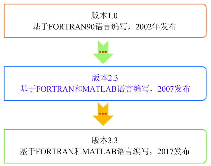
自2002年应用于植被物候信息提取以来,TIMESAT软件在经历了数据类型扩充和功能优化后,目前软件版本从1.0已升级为3.3(图1)。TIMESAT3.3提供了STL(seasonal-trend decomposition procedure based on loess)趋势分析和并行处理功能,可以把时间序列分解为趋势项(trend component)、季节项(seasonal component)和余项(remainder component)。
图1
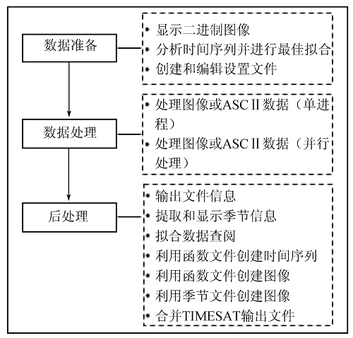
除了在改进MODIS和AVHRR卫星产品效果明显并成功提取物候信息外,TIMESAT软件还应用于处理气象数据、火灾数据和涡动协方差碳通量数据等方面。TIMESAT主要包括数据准备、数据处理和后处理3个模块(图2),可以提供11种植被物候参数,包括作物生长开始日期、生长结束日期、生长季长度和振幅等。
图2
2.1.2 SPIRITS软件
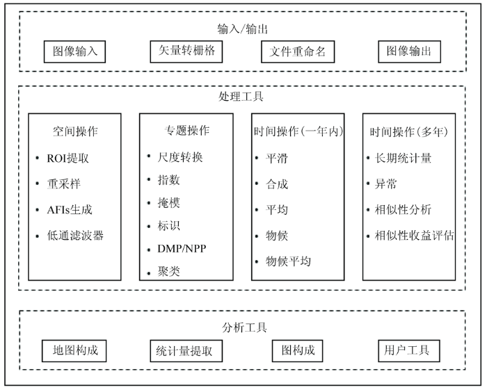
SPIRITS旨在为生产分析人员和决策者提供明确、可靠的信息,以特定的时间序列处理功能对作物和植被状况进行评估,包括时间平滑、物候阶段的检测、长期平均水平和异常的计算、基于植被季节性能的分类等。该软件图形用户界面灵活、友好,可以快速绘制植被指数及其异常,统计数据可以实现季节图分享给分析人员和决策者。
SPIRITS已发展成为用中、低空间分辨率卫星图像时间序列监测植被情况,且许多工具也可用于其他类型的栅格数据和应用领域(如森林和生境监测)。在作物监测中,常用的输入数据是地表反射、植被指数或生物物理参数,也可以处理从大气环流模式或地球同步卫星如METEOSAT获得的格网气象数据。SPIRITS多年来还扩展了许多其他模块,如外部格式图像的导入、地图生成和区域数据库的提取。该软件还使用了开源码库如GDAL(
图3
2.1.3 DATimeS软件
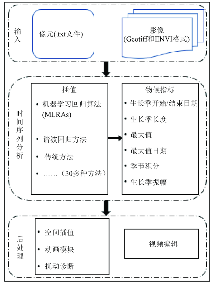
DATimeS是一个独立的具有图形用户界面的图像处理工具箱,集成了所有的插补和物候指标提取技术,便于作物监测应用程序的开展[25]。DATimeS由多个功能模块组成(图4),能对以多种格式(Geotiff和ENVI)表示的完整图像、特定ROI或单个像素规则或不规则时间序列数据建模和分析,其核心功能包括多个时间序列平滑和拟合算法。模块化的体系结构具有以下优势: ①通过处理步骤指导用户,即一旦当前模块完成后,后续处理模块被激活; ②在不影响主体架构下,模块可以很容易地修改或扩展; ③具有新功能的新模块很容易被添加到工具箱中。DATimeS软件的研发目标是提供一个通用和新颖的时间序列分析工具以保证有足够的灵活性捕捉植被的主要特征,同时不会对插补和随后的物候分析带来过量的计算或推理负担。相对其他具有图形用户界面的时间序列工具箱,DATimeS具有: ①处理不均匀间隔的卫星图像时间序列的能力; ②可以为时间序列预测(一些方法包含相关的不确定性,如高斯过程回归)选择超过12个不同机器学习拟合方法的可能性; ③提供和分析多个生长季节的物候指标。对Sentinel-2叶面积指数(leaf area index,LAI)时间序列的多重插值方法的初步评价表明,高斯过程回归作为一种最优算法在成功重建植被指数和提取可靠的物候指标方面具有潜力。同时,DATimeS还通过多种方式不断改进和扩展,如支持新的图像格式(如NetCDF和Sentinel图像的原生格式JPEG2000)、更多的物候指标(如每个季节生长季开始到生长最大值之间的生长率)、土地覆盖图加载时每个地块尺度的聚合处理、收获趋势和自动干扰检测的最新工具等。
图4
2.2 现有时间序列软件研发特点及展望
随着利用遥感数据提取植被物候信息需求的增长和时间序列卫星遥感数据的多样性,专用物候信息提取软件的研发越来越受到重视。现有主流软件主要集成了相应的数据平滑重建方法,免费向非商业用途提供服务,且大多建有专有网页。TIMESAT软件有图形用户界面,所用编程语言保证了对MODIS或AVHRR数据产品的快速处理,且非常灵活,但该软件侧重于物候参数的提取。TimeStats,BFAST和Earth Engine App等软件为具有长期遥感数据档案(如MODIS)的数据挖掘提供了一些高级工具,主要面向高级用户(即遥感专家)。SPRIRITS,pyPhenology,CropPhenology和BEAST等软件在一个可通过图形用户界面访问的包中提供了一系列用于图像时间序列分析的有用例程集合。在这些工具箱中,TIMESAT发展最早,在植被物候监测中得到了最为广泛的应用和认可。但是,TIMESAT软件仅包含了3种算法,在应用过程中对于最优算法的选择存在较大的局限性,没有应用机器学习回归算法(machine learning regression algorithm,MLRAs)。目前,图像处理已进入了人工智能时代,机器学习算法已成为时间序列数据处理的有力工具[4,31]。MLRAs的高度适应性和通用性使其比传统的拟合函数能够精确地估计物候趋势或在时间序列中识别多个季节[32],DATimeS软件提供了最先进的MLRAs和其他时间序列工具箱(如TIMESAT,TimeStats和SPIRITS)中所用的传统方法,同时可为植被物候提取提供高级的建模技术。DATimeS软件扩充了已建立的时间序列插值方法和多种先进的机器学习拟合算法(如高斯过程回归),运用Sentinel时间序列数据在农业区的应用表明该软件插补性能精度高并可提供相关不确定性,还可在进一步量化不同作物季节间LAI波动基础上为特定作物类型提供物候指标,如需要使用具有多个物候周期的规则时间序列、图形用户界面的缺失、或仅仅针对高级用户或特定传感器时间序列数据等。此外,这些软件包在用于填补缺失值和平滑目的的算法有所不同。
地球系统科学进入了大数据时代,所带来的挑战是如何从这些大数据中快速有效提取并解读信息[33]。时空明确的植被物候知识是理解自然季节现象变化趋势的关键,并可为农业生产和全球变化研究提供服务[34]。随着时间序列遥感数据拟合的数据平滑方法的成熟发展,开发集成重建方法的专业软件有利于长时间序列遥感数据的应用[33]。本文所列举已研发成功的软件主要是针对美国国家航空航天局、欧洲航天局等机构所提供的长时间序列遥感数据,研发团队主要为从事植被物候研究或与农业生产者密切接触的科研人员,开发的软件界面语言主要为英语。这些主流软件为用户在提高植被物候信息提取的精度和效率时可根据数据类型和实际需要有更多的选择,也受到了国内科研人员的青睐。随着我国高分系列卫星的成功发射与应用,前所未有的遥感大数据满足了高时空分辨率、高光谱分辨率和高精度观测需求,从这些海量的时间序列遥感数据有效提取生产、社会发展和生态应用等所需时空变化地表参数已成为重要的现实需要。根据我国高分系列卫星数据特点并针对国内用户在植被物候研究和信息提取应用时的偏好,开发具有友好图形用户界面且集成更为实用重建算法的时间序列分析软件应是我国科研人员重视的一个方向。
3 结论
本文列举了已应用于植被物候监测的几款软件如TIMESAT,SPIRITS和DATimeS后,简单汇总比较了现有软件的特点。不同数据平滑重建算法对不同噪声点的重构、平滑以及高质量点的保持度等方面表现各异,现有软件的发展是根据不同遥感数据集成了相应的重建算法。用户在提取植被物候时可以根据需要进行选用,以满足植被物候信息提取精度。
文中所列举的软件主要是针对美国国家航空航天局、欧洲航天局等机构所提供的遥感数据研发的,软件界面语言为英文,不利于利用这些软件开展我国卫星遥感数据的应用推广。在遥感大数据背景下,研发针对国产遥感数据的以中文为界面语言的植被物候信息提取软件有助于提升我国在时间序列遥感数据应用的广度和深度。
参考文献
陆表定量遥感反演方法的发展新动态
[J].
Recent progress in land surface quantitative remote sensing
[J].
遥感时间序列影像变化检测研究进展
[J].
Review of remotely sensed time series data for change detection
[J].
An integrated phenology modelling framework in R
[J].DOI:10.1111/mee3.2018.9.issue-5 URL [本文引用: 2]
Force-Landsat+Sentinel-2 analysis ready data and beyond
[J].DOI:10.3390/rs11091124 URL [本文引用: 3]
Estimation methods developing with remote sensing information for energy crop biomass:A comparative review
[J].DOI:10.1016/j.biombioe.2019.02.002 URL [本文引用: 1]
遥感数据时空尺度对地理要素时空变化分析的影响
[J].
Impact of spatial and temporal scales of remote sensing data on the spatiotemporal change in geographic elements
[J].
Principled missing data methods for researchers
[J].DOI:10.1186/2193-1801-2-1 URL [本文引用: 1]
Multispectral high resolution sensor fusion for smoothing and gap-filling in the cloud
[J].
DOI:10.1016/j.rse.2020.111901
PMID:32943798
[本文引用: 1]

Remote sensing optical sensors onboard operational satellites cannot have high spectral, spatial and temporal resolutions simultaneously. In addition, clouds and aerosols can adversely affect the signal contaminating the land surface observations. We present a HIghly Scalable Temporal Adaptive Reflectance Fusion Model (HISTARFM) algorithm to combine multispectral images of different sensors to reduce noise and produce monthly gap free high resolution (30 m) observations over land. Our approach uses images from the Landsat (30 m spatial resolution and 16 day revisit cycle) and the MODIS missions, both from Terra and Aqua platforms (500 m spatial resolution and daily revisit cycle). We implement a bias-aware Kalman filter method in the Google Earth Engine (GEE) platform to obtain fused images at the Landsat spatial-resolution. The added bias correction in the Kalman filter estimates accounts for the fact that both model and observation errors are temporally auto-correlated and may have a non-zero mean. This approach also enables reliable estimation of the uncertainty associated with the final reflectance estimates, allowing for error propagation analyses in higher level remote sensing products. Quantitative and qualitative evaluations of the generated products through comparison with other state-of-the-art methods confirm the validity of the approach, and open the door to operational applications at enhanced spatio-temporal resolutions at broad continental scales.© 2020 The Authors.
Effects of different urbanization levels on land surface temperature change:Taking Tokyo and Shanghai for example
[J].DOI:10.3390/rs12122022 URL [本文引用: 1]
A review of vegetation phenological metrics extraction using time-series,multispectral satellite data
[J].DOI:10.1016/j.rse.2019.111511 URL [本文引用: 3]
Remote sensing of dryland ecosystem structure and function:Progress,challenges,and opportunities
[J].DOI:10.1016/j.rse.2019.111401 URL [本文引用: 2]
Real-time forecasting and visualization toolkit for multi-seasonal time series
[J].DOI:10.1016/j.envsoft.2018.03.034 URL [本文引用: 1]
A method for robust estimation of vegetation seasonality from Landsat and Sentinel-2 time series data
[J].DOI:10.3390/rs10040635 URL [本文引用: 1]
TIMESAT:A program for analyzing time-series of satellite sensor data
[J].DOI:10.1016/j.cageo.2004.05.006 URL [本文引用: 2]
Detecting trend and seasonal changes in satellite image time series
[J].DOI:10.1016/j.rse.2009.08.014 URL [本文引用: 1]
Timestats:A software tool for the retrieval of temporal patterns from global satellite archives
[J].DOI:10.1109/JSTARS.4609443 URL [本文引用: 1]
Image time series processing for agriculture monitoring
[J].DOI:10.1016/j.envsoft.2013.10.021 URL [本文引用: 1]
A web-based application for beekeepers to visualise patterns of growth in floral resources using MODIS data
[J].DOI:10.1016/j.envsoft.2016.05.010 URL [本文引用: 1]
pyPhenology:A python framework for plant phenology modelling
[J].DOI:10.21105/joss URL [本文引用: 1]
CropPhenology:An R package for extracting crop phenology from time series remotely sensed vegetation index imagery
[J].DOI:10.1016/j.ecoinf.2018.05.006 URL [本文引用: 1]
A Google Earth Engine-enabled software for efficiently generating high-quality user-ready Landsat mosaic images
[J].DOI:10.1016/j.envsoft.2018.11.004 URL [本文引用: 1]
Visualizing and labeling dense multi-sensor earth observation time series:The EO time series viewer
[J].DOI:10.1016/j.envsoft.2020.104631 URL [本文引用: 1]
DATimeS:A machine learning time series GUI toolbox for gap-filling and vegetation phenology trends detection
[J].DOI:10.1016/j.envsoft.2020.104666 URL [本文引用: 1]
Evidence of increased net ecosystem productivity associated with a longer vegetated season in a deciduous forest in southcentral Indiana,USA
[J].DOI:10.1111/gcb.2010.17.issue-2 URL [本文引用: 1]
Intercomparison,interpretation,and assessment of spring phenology in North America estimated from remote sensing for 1982 to 2006
[J].DOI:10.1111/gcb.2009.15.issue-10 URL [本文引用: 2]
Global land surface phenology trends from GIMMS database
[J].DOI:10.1080/01431160802562255 URL [本文引用: 1]
An enhanced TIMESAT algorithm for estimating vegetation phenology metrics from MODIS data
[J].DOI:10.1109/JSTARS.4609443 URL [本文引用: 1]
A spatially explicit land surface phenology data product for science,monitoring and natural resources management applications
[J].DOI:10.1016/j.envsoft.2014.11.017 URL [本文引用: 1]
Assessing spring phenology of a temperate woodland:A multiscale comparison of ground,unmanned aerial vehicle and Landsat satellite observations
[J].DOI:10.1016/j.rse.2019.01.010 URL [本文引用: 1]
Detecting change-point,trend,and seasonality in satellite time series data to track abrupt changes and nonlinear dynamics:A Bayesian ensemble algorithm
[J].DOI:10.1016/j.rse.2019.04.034 URL [本文引用: 1]
Optimizing Gaussian process regression for image time series gap-filling and crop monitoring
[J].DOI:10.3390/agronomy10050618 URL [本文引用: 1]
Quantifying vegetation biophysical variables from imaging spectroscopy data:A review on retrieval method
[J].
DOI:10.1007/s10712-018-9478-y
[本文引用: 1]
An unprecedented spectroscopic data stream will soon become available with forthcoming Earth-observing satellite missions equipped with imaging spectroradiometers. This data stream will open up a vast array of opportunities to quantify a diversity of biochemical and structural vegetation properties. The processing requirements for such large data streams require reliable retrieval techniques enabling the spatiotemporally explicit quantification of biophysical variables. With the aim of preparing for this new era of Earth observation, this review summarizes the state-of-the-art retrieval methods that have been applied in experimental imaging spectroscopy studies inferring all kinds of vegetation biophysical variables. Identified retrieval methods are categorized into: (1) parametric regression, including vegetation indices, shape indices and spectral transformations; (2) nonparametric regression, including linear and nonlinear machine learning regression algorithms; (3) physically based, including inversion of radiative transfer models (RTMs) using numerical optimization and look-up table approaches; and (4) hybrid regression methods, which combine RTM simulations with machine learning regression methods. For each of these categories, an overview of widely applied methods with application to mapping vegetation properties is given. In view of processing imaging spectroscopy data, a critical aspect involves the challenge of dealing with spectral multicollinearity. The ability to provide robust estimates, retrieval uncertainties and acceptable retrieval processing speed are other important aspects in view of operational processing. Recommendations towards new-generation spectroscopy-based processing chains for operational production of biophysical variables are given.
Deep learning and process understanding for data driven Earth system science
[J].DOI:10.1038/s41586-019-0912-1 URL [本文引用: 2]
