

0 引言
动物水产品是人类获取蛋白质的重要来源,根据联合国粮食及农业组织(Food and Agriculture Organization of the United Nations, FAO)统计,2018年全球鱼类产量约为1.79亿t,其中水产养殖产品占总产量的46% [1]。2019年中国水产养殖产量超500万t,其中养殖池塘产量占约49%[2]。低洼沿海地区是水产养殖最有利的地区,水产养殖业在中国沿海地区迅速扩张[3] 。珠江三角洲的基塘农业是我国水产养殖的重要方式之一。塘基上种桑、甘蔗和果树等,塘中养殖鱼、虾等,结合成为基塘系统。基塘系统是人工湿地的重要代表,具有保护生物多样性、蓄水调洪、固碳、风暴防御和净化水质等[4⇓⇓-7]功能。而随着国内外对水产品需求的不断增长,水产养殖业迅猛发展,养殖池塘面积发生巨大变化,养殖池塘水面面积不断扩张,造成了一系列的环境和社会经济问题[8-9]。因此对于水产养殖的研究是十分必要的。
相比于传统实地调查,遥感具有大范围、可持续、成本低的优势,能提供长时序的空间信息[10]。为了有效地绘制水产养殖池塘地图,遥感方法已逐渐从目视判读[11-12]发展到指数法[13]再到面向对象分类[14]和深度学习[15],已有学者运用这些方法进行了单时相和长时序的养殖池塘监测[16⇓-18]。而中山市及邻近区域桑基鱼塘的养殖模式,具有鱼塘分布密集连片,与塘基上的菜地、农田等混杂的特点,再加上遥感图像空间分辨率的限制,导致养殖池塘边界普遍存在混合像元。若不考虑混合像元对于养殖池塘监测的影响,往往会将养殖池塘配套基础设施(如塘基),错误识别为养殖池塘,难以得出准确的养殖池塘水面面积,对估算产量等后续工作造成困扰。
因此,本研究以中山市及邻近区域为研究对象,基于30 m空间分辨率的Landsat数据和10 m空间分辨率的Sentinel-2数据,进行光谱混合实验,在实验基础上通过目视选取水体和植被的端元波谱,利用完全约束最小二乘法进行混合像元分解,根据70%及以上水体丰度对应的归一化水体指数(normalized difference water index,NDWI)的阈值范围提取养殖池塘,以减少混合像元的影响。利用本研究方法获取中山市及邻近区域水产养殖池塘的时空分布,并对中山市及邻近区域1990—2021年水产养殖池塘的时空变化规律进行分析。
1 研究区及其数据源
1.1 研究区概况
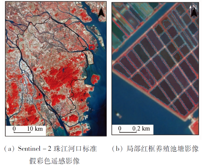
图1
1.2 数据源及其预处理
本研究以美国地质勘探局网站(
表1 卫星图像信息
Tab.1
| 日期 | 卫星影像 | 空间分辨率/m |
|---|---|---|
| 1990-10-13 | Landsat5 TM | 30 |
| 2000-09-06 | Landsat5 TM | 30 |
| 2010-03-26 | Landsat5 TM | 30 |
| 2020-02-08 | Landsat8 OLI | 30 |
| 2021-02-20 | Landsat8 OLI | 30 |
| 2020-10-26 | Sentinel-2 MSI | 10 |
| 2021-02-23 | Sentinel-2 MSI | 10 |
此外,选取2020年和2021年的Sentinel-2影像,用于对比分析混合像元对不同空间分辨率影像的影响。在数据预处理阶段,使用FLAASH模型对Landsat5 TM和Landsat8 OLI的L1级数据进行大气校正,以及使用Sen2Cor大气校正模型对Sentinel-2的L2A级数据进行大气校正,得到大气底层表观反射率数据。
2 研究方法
2.1 养殖池塘初步提取
养殖池塘作为人工水体,蓝光和绿光波段的反射率较高,在近红外和中红外波段,反射率很低[13]。为突出养殖池塘水体信息,使用NDWI对绿光波段和近红外波段进行组合运算,其计算公式为:
式中:
利用NDWI计算结果,根据经验及目视判别,选取阈值进行水陆分离。由于不同年份含沙量和悬浮物浓度等水体性质不同,阈值需要适当调整,本研究选取不同年份的阈值如表2所示。利用城镇、水系和林地矢量数据,对提取的水体进行擦除处理,根据假彩色遥感影像进行目视修正,剔除非水体和天然湖泊等非养殖池塘水体,初步得到养殖池塘的分布数据。由于城镇区域地物复杂,光谱混合现象严重,目前计算机自动提取的结果精度很难满足精细化提取的需求。因此,基于Landsat及Sentinel影像及相关的地图信息,本研究采用目视解译的方式提取了各期遥感影像中的城镇区域。
表2 不同年份NDWI阈值
Tab.2
| 年份 | 数据源 | NDWI阈值 |
|---|---|---|
| 1990年 | Landsat5 | [-0.15,1] |
| 2000年 | Landsat5 | [-0.12,1] |
| 2010年 | Landsat5 | [-0.03,1] |
| 2020年 | Landsat8 | [-0.09,1] |
| Sentinel-2 | [-0.11,1] | |
| 2021年 | Landsat8 | [-0.10,1] |
| Sentinel-2 | [-0.07,1] |
2.2 混合像元分解方法
在珠江三角洲的基塘农业模式中,塘基上多有菜园和花田等绿色植被分布,使得植被和水体的混合像元普遍存在于NDWI初步提取结果中,因此本研究只利用水体和植被端元波谱进行混合像元分解,不再考虑水体与裸土、建筑物的混合像元。
常见的混合像元分解模型分线性模型和非线性模型2类。在线性模型中,一般认为单一像元的反射率为端元组分的特征反射率与各自丰度的线性组合。线性分解模型为:
式中: i=1,2,3,…,m; j=1, 2, 3,…, n; γi为混合像元的反射率; aij为第i个波段第j个端元组分的反射率;
在无约束或者半约束线性分解模型中,会出现负值或者大于1的情况,这与实际的物理意义相违背。因此,利用完全约束最小二乘法进行混合像元的分解,其具有模型结构简单、端元数目较少的情况下计算速度快的特点[23]。利用完全约束最小二乘法进行混合像元的分解,保证了像元中的组分所占比例位于[0,1]范围内,所有组分之和为1。
3 结果与分析
3.1 混合像元分解结果
以2020年的Landsat8 和 Sentinel-2 遥感影像为数据源,进行光谱混合实验,从而获取遥感影像混合像元分解的先验知识[24]。在Landsat8影像和Sentinel-2影像的对应位置和相同区域,通过目视选取水体和植被纯净像元,其中在30 m空间分辨率的Landsat8影像上选取水体和植被纯净像元各400个像素,对应到10 m空间分辨率的Sentinel-2影像中为水体和植被纯净像元各4 900个像素。通过调整水体和植被纯净像元的像元个数配比,输出不同混合比例的平均光谱,以模拟不同情况下的光谱混合现象。随着水体纯像元占比增加和植被纯像元占比减少,模拟混合光谱的特征由类似植被光谱转向类似水体光谱(图2)。
图2
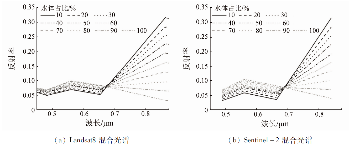
图2
水体和植被不同比例混合的光谱曲线
Fig.2
Spectral curves of mixing water and vegetation in different proportions
利用光谱混合实验中选取的植被和水体的纯净像元,计算纯净像元的平均波谱,作为水体和植被的端元波谱(图3),对2020年和2021年Landsat8和Sentinel-2影像提取的养殖池塘进行解混,得到水体丰度图(图4)。根据水体丰度的统计分析和目视对比(表3),误提取的区域(塘基和道路)水体丰度比较低,而养殖池塘水面丰度高。因此本研究最终选取水体丰度70%及以上的区域,作为养殖池塘水面的范围。2010年及以前影像没有Sentinel-2数据辅助,难以选取纯净像元,因此不能利用水体丰度进行NDWI阈值的调整。本文通过选取样本点建立Landsat5 NDWI和Landsat8 NDWI的转换关系,将Landsat8的阈值转换为Landsat5的结果。在1990年、2000年和2010年的Landsat5影像和2021年Landsat8影像上目视选取植被和水体像元,各80个,并统计其对应NDWI的值,建立2021年Landsat8 NDWI(x)与其他各年份Landsat5 NDWI(y)的线性关系。根据2021年NDWI选取的阈值范围利用线性关系调整其他年份阈值(表4),利用调整后的阈值提取养殖池塘水面范围。
图3
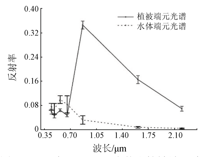
图3
2020年Landsat8水体和植被端元波谱
Fig.3
Reflectance of water and vegetation in the Landsat8 image in 2020
图4
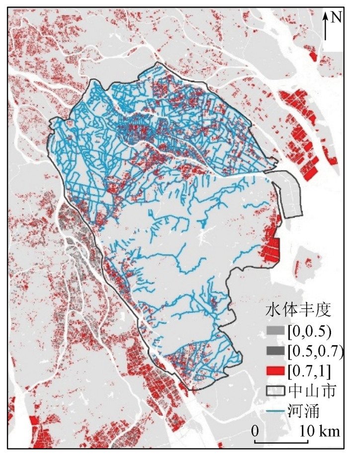
图4
基于2020年2月8日遥感图像反演的养殖池塘水体丰度
Fig.4
Abundance of aquaculture pond water based on remote sensing image inversion on February 8, 2020
表3 水体丰度0.7及以上的养殖池塘统计
Tab.3
| 年份/卫星 | 池塘面积/km2 | 面积占 比/% | NDWI阈值 |
|---|---|---|---|
| 2020年/Landsat8 | 357 | 73 | [-0.09,0.69] |
| 2020年/Sentine-2 | 426 | 99 | [-0.10,0.90] |
| 2021年/Landsat8 | 303 | 68 | [-0.10,0.69] |
| 2021年/Sentinel-2 | 360 | 77 | [-0.08,0.80] |
表4 NDWI阈值调整
Tab.4
| 年份 | 线性关系 | 调整前阈值 | 调整后阈值 |
|---|---|---|---|
| 1990年 | [-0.15,1] | [-0.06,0.47] | |
| 2000年 | [-0.12,1] | [-0.10,0.51] | |
| 2010年 | [-0.03,1] | [-0.01,0.22] |
3.2 养殖池塘时空变化
图5
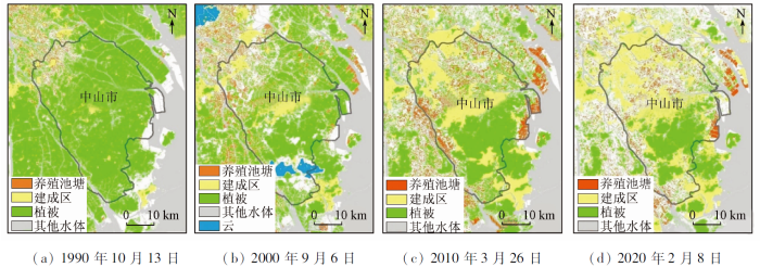
图6
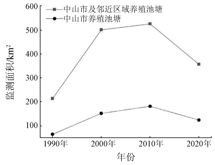
图6
研究区养殖池塘年际变化
Fig.6
Interannual variation of aquaculture ponds in the study area
具体而言,1990年中山市及邻近区域养殖池塘面积为213 km2,2000年养殖池塘面积为501 km2,1990—2000年池塘养殖面积增加了一倍多; 2000—2010年养殖池塘面积变化相对平稳,仅增长了25 km2; 2020年养殖池塘面积为357 km2,相比2010年减少了169 km2,2010—2020年养殖面积则减少了近50%。1990—2020年,养殖池塘面积的最大变化幅度为288 km2,最大变化率为135%。2000年遥感影像中云的面积约为118 km2,因有云遮挡影响而少提取的池塘面积约为52 km2。1990—2020年,中山市养殖池塘的时空变化与整个研究区类似,养殖池塘的面积也经历了一个快速增长而后缓慢减少的变化过程。具体来说,1990年养殖面积为64 km2增长到2000年的152 km2,池塘面积增长了88 km2,是面积增长最快的时间段。2010年中山市养殖池塘的面积达到顶峰,2010年以后养殖池塘的面积逐渐减少。
20世纪80年代中国的渔业以捕捞为主,养殖为辅,到了90年代尤其是1993以后养殖业产量开始远远超过捕捞[1]; 改革开放以后,在市场经济作用下,区域经济快速发展带动水产业快速发展[27],再加上基塘生态系统的多种改造完善[28],共同促成了1990—2000年间养殖池塘面积的快速增长。河涌是指用于防洪、排涝、排水、航运的天然河道(河流干流和溪流河流除外)、人工水道或者人工湖泊,具有重要的生态功能和经济功能。河涌是养殖池塘排水、蓄水的重要通道。如图4所示,中山市的河涌主要分布于北部。1990年中山市的池塘养殖区域仅分布于西北部,而2020年池塘养殖区域向南部和东部迅速扩张。这里正是中山市河涌较为密集的地区之一,可见河涌的分布是影响养殖池塘空间分布变化的原因之一。
4 结论
本研究基于30 m空间分辨率的Landsat数据和10 m空间分辨率的Sentinel-2数据,通过目视选取水体和植被的端元波谱,利用完全约束最小二乘法进行混合像元分解,根据水体丰度70%及以上对应的NDWI的阈值范围提取养殖池塘,获取中山市及邻近区域水产养殖池塘的时空分布。并分析在城市扩张下中山市及邻近区域1990—2021年间水产养殖池塘的时空变化规律,主要结论如下:
1)本研究使用Landsat与Sentinel-2卫星影像,通过线性混合像元分解和目视对比,提取水体丰度70%及以上的养殖池塘范围作为养殖池塘水面,能够减少混合像元对于池塘面积提取的影响。
2)研究区养殖池塘由1990年仅分布于西北部地区,逐渐向南部和东部扩张,至2020年广泛分布于中山市及邻近区域。1990—2000年养殖池塘面积增长一倍多; 2000—2010年养殖池塘面积变化相对平稳,增长幅度较小; 2010—2020年养殖池塘的面积更是不增反降,2020年养殖池塘面积为357 km2,相比2010年减少了近50%。
本研究基于水体和植被混合像元分解方法的养殖池塘水体提取方法,在水热条件好、植被生长状况良好的亚热带珠江河口地区有较高的适用性; 该遥感监测结果则可为该区域渔业及经济发展提供数据参考。当该方法应用于季节差异性较大的其他区域时,如黄河三角洲等,遥感影像时相及混合像元的端元光谱则需结合实际情况选择,并进一步优化该方法的参数。
参考文献
The state of world fisheries and aquaculture (SOFIA)
[R].
Rapid expansion of coastal aquaculture ponds in China from Landsat observations during 1984—2016
[J].DOI:10.1016/j.jag.2019.101902 URL [本文引用: 1]
Geospatial analysis of wetland dynamics:Wetland depletion and biodiversity conservation of Isimangaliso Wetland,South Africa
[J].DOI:10.1016/j.jksus.2018.03.004 URL [本文引用: 1]
Spatial and temporal evolution characteristics of the water conservation function and its driving factors in regional lake wetlands:Two types of homogeneous lakes as examples
[J].DOI:10.1016/j.ecolind.2021.108069 URL [本文引用: 1]
Measurement and economic valuation of carbon sequestration in Nova Scotian wetlands
[J].DOI:10.1016/j.ecolecon.2020.106619 URL [本文引用: 1]
The value of China’s coastal wetlands and seawalls for storm protection
[J].DOI:10.1016/j.ecoser.2019.100905 URL [本文引用: 1]
基塘系统中水产养殖对环境的影响
[J].
The effect of aquaculture in the dike-pond ecosystem on environment
[J].
High levels of microplastic pollution in aquaculture water of fish ponds in the Pearl River Estuary of Guangzhou,China
[J].DOI:10.1016/j.scitotenv.2020.140679 URL [本文引用: 1]
水产养殖区域的遥感识别方法进展
[J].
Progress in the methods for extracting aquaculture areas from remote sensing data
[J].
Assessment of aquaculture impact on mangroves of Mahanadi delta (Orissa),east coast of India using remote sensing and GIS
[J].DOI:10.1016/j.ocecoaman.2011.07.013 URL [本文引用: 1]
1985 年和 2010 年中国沿海盐田和养殖池遥感监测
[J].
Monitoring of salt ponds and aquaculture ponds in the coastal zone of China in 1985 and 2010
[J].
利用改进的归一化差异水体指数(MNDWI)提取水体信息的研究
[J].
A study on information extraction of water body with the modified normalized difference water index (MNDWI)
[J].
基于ONDPI的海岸养殖池塘遥感影像提取研究
[J].
Research on remote image extraction of coastal aquaculture pond based on ONDPI
[J].
Research on a novel extraction method using deep learning based on GF-2 images for aquaculture areas
[J].DOI:10.1080/01431161.2019.1706009 URL [本文引用: 1]
Tracking changes in aquaculture ponds on the China coast using 30 years of Landsat images
[J].DOI:10.1016/j.jag.2021.102383 URL [本文引用: 1]
Remote monitoring of expansion of aquaculture ponds along coastal region of the Yellow River Delta from 1983 to 2015
[J].DOI:10.1007/s11769-017-0926-2 URL [本文引用: 1]
基于 RS 与 GIS 的珠江口养殖用地时空变化分析
[J].珠江口地区是我国重要的养殖基地,近20年来养殖业在数量和空间分布上发生了较大的变化。利用遥感(RS)及地理信息系统(GIS)技术能够有效监测珠江口海岸带地区水产养殖场的变化。本文应用1990年、2000年、2005年和2008年4个时相的遥感数据,采用面向对象的方法,综合光谱、空间关系和形状特征信息进行了养殖用地的提取。结果表明1990年-2000年珠江口沿岸地区养殖用地面积有较大增长。2000年-2005年该地区养殖用地变化强度减弱。2005年-2008年西岸养殖用地仍然保持增长,而东岸却大幅减少。对养殖用地重心的迁移距离和迁移方向进行分析,结果表明1990年-2008年珠江口东西岸养殖用地均呈向西北方向迁移的模式。研究期内增加的养殖用地主要来源于滩涂围垦和农业用地,而减少的养殖用地主要转化为城镇用地。该研究客观、准确的反演了海岸带养殖用地的动态变化过程,对海岸带土地资源的可持续开发利用研究具有一定的理论和现实意义。
Analyses on spatial-temporal changes in aquaculture land in coastal areas of the Pearl River Estuarine
[J].The coastal zone of the Pearl River estuarine is one of the most important regions in China as far as aquaculture is concerned. In the past twenty years, the rapid development of aquaculture industries has resulted in significant changes in land use patterns and a series of eco-environmental problems as well. Dynamic monitoring spatial and temporal changes in aquaculture land by using remote sensing and GIS techniques would therefore result in efficient use of land resources and provide valuable information on aquaculture management, planning and decision-making with the objective of ensuring long-term sustainability development of the coastal zones. In order to extract aquaculture land, a feasible object-oriented classification method incorporating spatial and spectral information of image objects was applied to Landsat ETM imageries acquired in 1990, 2000, 2005 and CBERS-02B imagery acquired in 2008 covering the coastal zone of the Pearl River estuarine. Results indicated that in general, the total area of aquaculture increased significantly from 1990 to 2000. Meanwhile, the increase degree of aquaculture land slowed down gradually during the period of 2000 to 2005. It was also found that from 2005 to 2008 the aquaculture land began to decrease, particularly over the east coast of the Pearl River estuarine. Dynamic degrees of changes in aquaculture land across different buffers also showed different characteristics. From 1990 to 2000 the dynamic degree over the west coast areas was 0.31 and the highest value occurred in the buffer five. The highest value of dynamic degree of 0.02 over the east coast occurred in the buffer one while dynamic degrees in the other four buffers showed negative values during the same period. By examining the change direction and magnitude of aquaculture land centroids it was found that from 1990 to 2008, the aquaculture land in both coast areas of the Pearl River estuarine showed a transition trend from the east to the west. It was concluded that the increased aquaculture land was primarily converted from agricultural land and sea water bodies, with showing a convention ratio of about 55.71% and 38.60%, respectively. The loss of aquaculture land was basically converted into building areas, showing a convention ratio of roughly 82.3%. Also, main driving forces for these changes in aquaculture land were investigated and elaborated in detail. Urbanization and pursuit of greater profits were considered the main forces of the changes.
Development and current state of seawater shrimp farming,with an emphasis on integrated multi-trophic pond aquaculture farms,in China:A review
[J].DOI:10.1111/raq.12457 URL [本文引用: 1]
基于线性光谱模型的混合像元分解方法与比较
[J].
Pixel unmixing based on linear spectral mixture model:Methods and comparison
[J].
混合像元分解技术及其进展
[J].
Research progress of spectral mixture analysis
[J].
混合像元分解模型综述
[J].
A review of pixel unmixing models
[J].
高光谱遥感影像混合像元分解研究进展
[J].
Research progress on unmixing of hyperspectral remote sensing imagery
[J].
混合光谱分解实验研究
[J].
An experiment on spectral unmixing
[J].
近20年来珠江三角洲滨海湿地景观的变化特征
[J].
Variations of coastal wetland landscapes in the Pearl River Delta in the last 20 years
[J].
中山市基塘农业模式演变及景观格局分析
[J].
Analysis on mode change and landscape pattern of the dike-pond agriculture in Zhongshan
[J].
Spatial-temporal change analysis of water area in Pearl River Delta based on remote sensing technology
[J].DOI:10.1016/j.proenv.2011.09.340 URL [本文引用: 1]
珠江三角洲基塘系统演化及生态修复策略——以佛4村为例
[J].
DOI:10.18402/resci.2021.02.11
[本文引用: 1]

珠江三角洲基塘系统是中国重要农业文化遗产,其宏观格局变化已广受关注,但微观村落层面的研究还未得到足够重视。本文构建了珠江三角洲基塘系统演化概念性分析框架,以佛山市西桥社区、南金村、青田村、仕版村为例,采用实地调研与半结构式访谈,分析基塘系统的演化过程、特征与机制。研究结果表明:①基塘系统已由原有种养结合转为单一高密度养殖塘,但邻近村居聚落的基塘系统与生活空间紧密结合,形成生态景观塘、菜基鱼塘等;②城镇化、工业化背景下村集体经济组织和农户“经济效益至上”的经营管理模式是基塘系统演化的内在动力;③转变基塘经营模式,发挥基塘综合效益,合理治理基塘与城乡空间的交错地带,与基塘农业文化遗产及乡村文化保育相结合,是实施基塘系统生态修复的关键。本文结果有助于揭示重要农业文化遗产动态演变规律,可为珠江三角洲农业可持续发展、国土空间规划提供理论依据。
Change and ecological restoration of the dike-pond system in the Pearl River Delta:A case study of four villages in Foshan City
[J].
