

0 引言
2022年9月5日12时52分,四川省甘孜藏族自治州泸定县发生6.8级地震,震源深度为16 km,震中位于N29.59°,E102.08°。地震诱发震中附近山体发生滑移,部分土质松动,造成了泸定县和石棉县境内多处山体滑坡,给当地居民的生产生活带来严重威胁。地震诱发的滑坡灾害具有规模大、分布范围广、破坏性强的特点,快速而准确地获取滑坡信息是进行应急救援和灾害分析、评价的基础,也是目前亟待解决的问题[1]。
传统的基于遥感影像进行滑坡提取的方法主要是人工目视解译和基于像素的图像分类方法。人工目视解译利用专家经验知识提取滑坡,这种方法准确度较高,但由于工作量大,花费时间长且效率不高,不适用于震后大面积滑坡的快速提取。基于像素的方法利用不同像素间的光谱信息差异提取滑坡,但是由于“同物异谱,异物同谱”现象的存在,提取结果容易出现“椒盐”现象,对滑坡提取精度造成影响[2-3]。随着光学遥感影像空间分辨率的提高,影像中的光谱、纹理等信息更加丰富,面向对象的滑坡提取方法应运而生[4⇓⇓-7]。面向对象方法首先分割同质性强的像元集合得到影像对象,以对象为基础,综合考虑滑坡的光谱、纹理、形状和上下文等信息进行识别和分类。国内外已有许多专家学者利用面向对象方法进行滑坡信息提取[8⇓⇓⇓-12]。Barlow等[13]基于面向对象方法,添加地形信息克服图像分辨率不足的影响,综合利用光谱、形状和地形信息构建分级分类系统,识别出研究区近75%的滑坡; Martha等[14]针对小区域滑坡使用多光谱影像,综合利用数字高程模型(digital elevation model,DEM)数据和光谱、形状与上下文信息将滑坡从易混淆地物中分离出来; 林齐根[15]使用高分辨率遥感影像综合光谱、空间、地形和形态特征,构建滑坡提取特征规则集,实现了大范围滑坡的快速提取。上述研究利用面向对象方法针对不同类型的滑坡进行了有效提取,但对于不同数据源和不同背景和地形特征的滑坡不具有普适性。
此外随着深度学习技术的发展,许多成熟的深度学习算法被引入遥感领域并广泛应用于滑坡提取中。目前已有许多学者进行了基于语义分割的滑坡提取应用研究[16⇓⇓-19]。Prakash等[20]使用一种改进的U-Net模型,以ResNet-34为主干网络进行特征提取,在美国俄勒冈州滑坡提取中取得了较好的检测结果; Liu等[21]使用资源三号高空间分辨率数据,基于3种网络模型,将与滑坡发生相关的地形和地质数据因子与遥感影像共同输入模型进行滑坡提取,对比不同语义分割模型的精确度,获得了比无辅助信息更好的提取结果; 王欣等[22]利用无人机遥感数据,基于Segformer模型对泸定地震引发的同震滑坡进行了识别,取得了较好的综合效果; 陈扬洋[23]在香港大屿山滑坡检测中,综合考虑视觉检测概率和滑坡易发概率,利用基于语义分割的滑坡检测模型获得了良好的检测结果。综合来说,深度学习方法能够通过多层网络自动提取出从浅层具象到深层抽象的多级特征,深入挖掘遥感影像中的高层特征信息,提高滑坡识别任务的精度[24-25]。但基于目前的样本数据和计算条件,深度学习方法的遥感领域应用仍具有局限性: 在深度学习提取滑坡的应用多数采用无人机影像,对特定的滑坡提取应用场景,大范围快速获取无人机数据仍具有一定难度; 受反复卷积和池化的影响,深度学习方法在多次特征提取和抽象中导致地物边界模糊,使得最终提取结果的几何精度受限[26]; 同时深度学习模型训练过程需要大规模样本数据集的支撑,而大量的样本标签人工勾画过程费时耗力,不利于地物信息的快速提取。
因此,本研究在深入分析影像地物特征和地形相关性的基础上,面向泸定地震引发的大范围滑坡快速提取的具体需求,采用国产高空间分辨率光学卫星影像,利用面向对象的影像分类方法,进行震后震前滑坡信息提取和双时相影像滑坡范围变化检测,分析滑坡空间分布与各地形和断裂带的相关关系,为地震应急和震后的灾情调查提供可靠的信息支持。
1 研究区概况和数据源
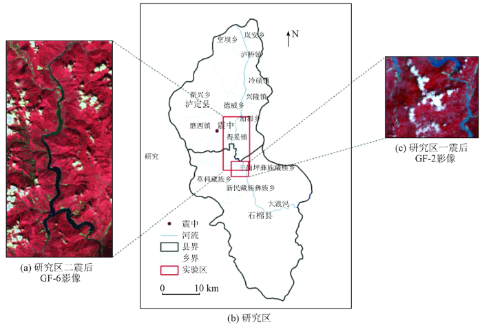
1.1 研究区概况
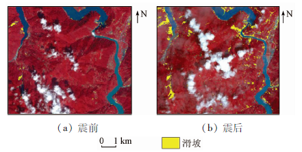
图1
1.2 数据源及其预处理
研究区一使用了2景不同时相的GF-2数据,研究区二使用了2景不同时相的GF-1与GF-6数据。由于裸地在滑坡信息提取的研究中,一直是影响较大的干扰因素。根据植被生长周期,研究选取影像的拍摄时间内,植被生长茂盛,尽可能地减少了裸地对滑坡信息提取精度的干扰。研究区一的GF-2数据分别拍摄于震前2021年9月30日和震后2022年9月10日,全色和多光谱波段空间分辨率分别为1 m和4 m。研究区二的GF-1数据拍摄于震前2022年7月23日,GF-6数据拍摄于震后2022年9月10日,全色和多光谱波段空间分辨率分别为2 m和8 m。DEM数据空间分辨率为12.5 m。
2 研究方法
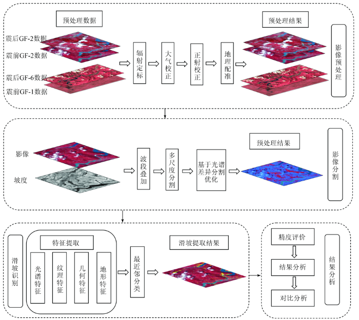
2.1 总体技术路线
本文使用GF-2和GF-6数据,首先在ENVI软件进行包括辐射定标、大气校正、正射校正和图像融合的预处理; 然后将同一研究区的2景双时相高分影像在ArcMap中进行地理配准,将预处理后高分影像与地形因子进行图层叠加; 然后基于eCognition平台对叠加得到的影像进行多尺度分割; 在加入光谱、纹理、地形特征后,选用最近邻分类器识别滑坡对象并进行精度评价。本文利用小范围研究区一探索方法可用性,利用大范围研究区二提取泸定震后滑坡信息。主要方法流程如图2所示。
图2
2.2 影像预处理
影像预处理是为了纠正在遥感影像成像过程中,由于传感器外在原因和成像环境造成的遥感影像的几何畸变、辐射畸变和大气效应,提高后续影像分割、特征提取的可靠性。预处理流程包括多光谱影像的辐射定标、大气校正和正射校正,以及全色影像的辐射定标和正射校正,然后对多光谱和全色影像进行融合操作,最后对融合后的双时相影像进行地理配准。
2.3 影像分割及分割优化
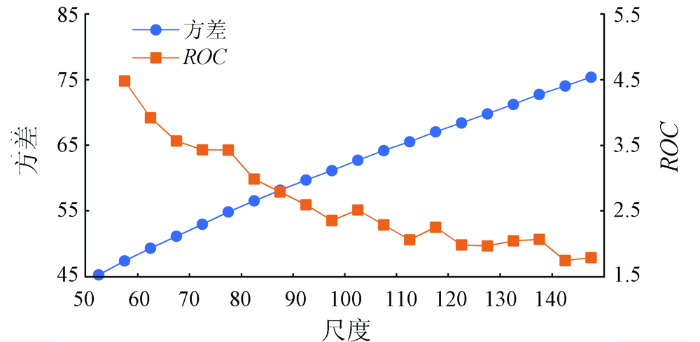
影像中不同地物间异质性随分割尺度变化存在较大差异。首先通过基于经验的试错法,将形状因子和紧致度因子分别设为0.3和0.6。由于分割尺度选取结果仅仅依据经验和目视判读容易忽略复杂地物对象中的细微变化,研究中借助尺度参数估计(estimation of scale parameters,ESP)工具辅助定量化选取最优分割尺度[33-34]。假设地物对象与背景存在差异,随着分割尺度的增大,对象内的平均方差也会逐渐增大,当达到最优分割尺度后,对象内的方差会趋于平稳。而一种地物对象的平均方差的停滞会对整体的方差造成影响,为了更明显看到随分割尺度的改变的方差变化趋势,引入ROC(rate of change)分析变化特征[35],公式为:
式中: V为当前分割层所对应的方差; V1为上一个分割层对应的方差。在确定最佳分割参数的过程中,首先固定异质性标准,比较不同分割尺度的分割效果。从图3中可以看出,ROC曲线整体呈现下降趋势,下降曲线出现的第一个峰值出现在100左右,为避免“欠分割”现象,将第一个峰值出现的分割尺度定义为最优分割尺度,最终确定多尺度分割的参数为100,0.3和0.6。
图3
以植被、滑坡、水体为例,采用以上分割参数的分割结果见图4(a),(f),(k),可以看出影像中存在明显的“过分割”现象,因此本文在后处理阶段利用光谱差异分割对多尺度分割结果进行优化。这种分割算法是在已有的影像对象基础上,通过分析相邻对象的均值层亮度值差异是否满足给定的阈值,来决定是否将临近对象进行合并,通过设定合适的阈值,该算法能够将亮度值较为接近的对象合并,减少分割对象的数量[30]。基于光谱差异的分割优化结果如图4所示。图4表明随着光谱差异分割参数的增大,影像对象的面积逐渐增大,影像分割结果的破碎度变小,但是当光谱差异分割参数大于150之后,道路附近的小型滑坡和道路对象合并,出现欠分割。因此为保证最佳滑坡提取效果,最终确定光谱差异分割参数为150。
图4
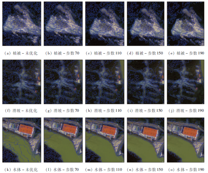
图4
不同参数下的光谱差异分割后处理结果
Fig.4
Post-processing results of spectral difference segmentation with different parameters
2.4 分类特征
研究区中主要对象类别除滑坡外还包括云、建成区、河流、植被、河漫滩等。通过分析研究区影像上不同地物光谱和形状特征,同时结合地物的内部属性和空间关系,选取光谱、地形、各种专题指数及几何纹理特征因子来剔除这些类别的干扰,减少滑坡对象识别过程中与相邻地物边界误分和相似地物混淆的情况,提高滑坡信息提取的精度。实验中使用的分类特征共12个。
根据影像中滑坡发生的地形特点,实验中选取的地形因子为坡度。研究区中滑坡主要发生在河两岸的山坡和山体的两侧上,滑坡发育的优势坡度范围较集中。且当坡度小于10°时,坡体较为稳固,这一区域也是建成区、河漫滩的主要分布地区,与滑坡区域分布差别较为明显。
影像中的各层亮度均值可有效区分不同地物,云层在蓝光波段特征明显,相比影像中的其他对象,云层的亮度值更高; 滑坡发生区植被稀疏,可以利用归一化差异植被指数(normalized difference vegetation index,NDVI)与植被进行有效区分; 水体和河漫滩相比,其归一化差异水体植被指数(normalized difference water index,NDWI)值更大; 陆地水体掩模指数(land and water masks,LWM)的计算借鉴了MODIS陆地水面覆盖数据产品的思想(式(2))[15],主要用于区分滑坡区与阴影区,无论是山体阴影还是云层阴影,其LWM值都比滑坡更高。
式中R,G和NIR分别为红光、绿光和近红外波段的光谱值。
道路和建成区在光谱特征上与滑坡相似,但其长度、长宽比远远高于其他地物; 建成区对象形状规则,地物信息丰富,信息熵更大。因此,研究中选取的几何纹理特征包括面积、长度、长宽比、形状指数和蓝波段灰度信息熵。
3 结果分析
3.1 小区域研究区滑坡提取结果分析
利用以上特征使用最近邻分类器对研究区一中的滑坡进行提取,最终的滑坡提取结果如图5所示。
图5
研究区一震后滑坡提取面积共计为1.67 km2,总体识别精度为92.3%; 震前滑坡提取面积共计0.26 km2,总体识别精度为85.1%。
根据提取结果,与目视解译结果进行对比分析,研究区一内,震前滑坡正确提取率76.27%,震后滑坡正确提取率79.1%。错分的主要地物为部分与滑坡特征相近的河漫滩,建成区人工构建的防滑区、建筑物以及部分薄云边缘。漏分的主要多为历史滑坡,这部分区域虽然保留了部分滑坡纹理特征,但由于演变时间较长,滑坡发生区自然生态恢复,有一定的植被覆盖,造成漏检。
3.2 双时相滑坡提取结果分析
通过小区域范围内研究结果可知,上述方法流程能较好地提取出研究区内滑坡。将该方法应用于研究区二,滑坡提取结果如图6所示。研究区二震前滑坡提取面积共计3.05 km2,总体识别精度为92.3%,震后滑坡提取面积24.99 km2,总体识别精度为95.4%。
图6
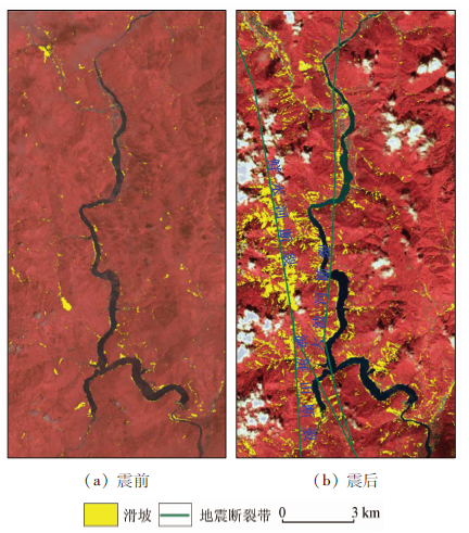
震前震后双时相高分影像滑坡提取结果对比,如图7所示。震后新增滑坡23.91 km2,历史滑坡区域面积3.05 km2,其中光谱未变化历史滑坡区域面积1.08 km2,光谱发生变化区域的历史滑坡区域面积1.97 km2。由于震前震后遥感影像时相相差2个月,且拍摄日期都处于植被生长繁盛期,对于光谱信息发生变化的历史滑坡,初步排除新生植被对历史滑坡的覆盖; 通过对比光谱发生变化的历史滑坡区域的地震前后影像,初步分析光谱信息发生变化是由于地震引发坡体发生物质运移,在历史滑坡上方产生堆积,造成部分历史滑坡区域产生异于传统滑坡的特殊光谱特征,导致震后影像中未能准确识别该区域历史滑坡。震后滑坡在研究区二涉及的7个乡镇均有分布,总体上沿水系带状分布,沿山坡沟谷带状分布。
图7
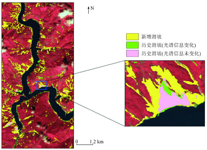
图8
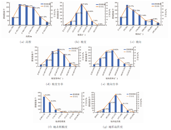
图8
震后滑坡随地形因子分布统计图
Fig.8
Post-earthquake landslide distribution statistics with terrain factors
图9
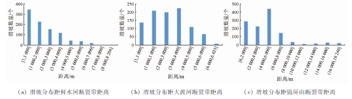
由图6—9可知:
1)根据图6(a)震前滑坡提取结果,研究区二震前滑坡分布高程在1 000~2 500 m之间,坡度分布集中在20°~50°范围内; 震后滑坡分布高程范围变化不大,坡度分布范围扩大,集中在12°~62°范围内; 坡度变率集中在11°~51°范围内; 坡向变率集中在14°~60°范围内; 地形起伏度集中在93°~189°范围; 滑坡随坡向的分布关系不明显。滑坡分布与地表粗糙度存在明显的负相关关系,沿高程垂直分布,沿坡度、坡度变率、坡向变率、地形起伏度集中分布。
2)根据震前影像,河流两侧和山体沟谷是滑坡的易发区,在地震之后,滑坡区域扩大。如图7所示的震前震后的滑坡提取叠加显示此次地震导致河流两侧部分历史滑坡出现再次滑动,并且出现了新发生的滑坡。新增滑坡的主要区域为河流沿岸的陡坡,道路边坡和震中附近的山坡。地震之后新增滑坡主要呈现2种分布特征: 沿河流呈带状分布、沿震中附近山坡沟谷片状密集分布。
3)根据图9统计分析结果,滑坡分布只与距鲜水河断裂带的距离呈现明显的负相关关系,随着距离的增大,滑坡分布面积减少,山坡沟谷中的大面积片状滑坡位于鲜水河断裂带东西两侧,沿大渡河向北曲行,距离鲜水河断裂带渐远,沿岸滑坡数量和规模逐渐减少。初步判断实验区内的滑坡主要受鲜水河断裂带影响。山坡沟谷中的片状滑坡区域靠近断裂带且地形属于坡面深切而狭窄的沟谷地貌,深受高地震烈度影响且符合滑坡发育的条件; 沿河流呈带状分布的滑坡区域位于河谷狭长陡峭的大渡河两岸和建成区周围河漫滩两岸,大渡河两岸坡体高程相差100~700 m不等,坡度集中在25°~50°,并且是历史滑坡发生的集中点,高陡岸坡和狭窄沟道为地震滑坡灾害的发生提供了有力条件[38]。
4 结论
本文针对2022年泸定6.8级地震引发的大量同震滑坡,将面向对象方法运用于地震前后滑坡识别,根据滑坡解译专家知识,针对研究区不同尺寸的对象,利用多尺度分割并逐步优化获取对象准确边界,综合图像光谱、专题指数、几何纹理及地形特征,分类得到滑坡提取结果。本文选取研究区一验证方法可行性,选取研究区二研究此次地震引发的滑坡分布,对比分析了地震前后滑坡面积变化。本文工作充分发挥了国产高分光学卫星影像在地震前后滑坡灾害提取中的应用价值,利用地形和专题指数等特征降低了滑坡的错检率,且该方法所需样本较少,样本生成过程简单,滑坡识别过程机理可解释性强,能够快速且准确地提取清晰的滑坡边界。通过滑坡空间分布与地形因子、断层的相关统计分析,确定了诱发滑坡分布的重要影响因素,为滑坡危险性评价、防灾减灾提供了理论支撑; 同时,震后同震滑坡的提取结果,也为灾后调查和灾情评估提供了辅助数据。
研究中提取震前滑坡面积3.05 km2,占研究区面积的0.91%。震前滑坡分布主要位于大渡河沿岸河谷陡坡,山体沟谷中也有零星分布。震后滑坡面积24.99 km2,占研究区面积的7.48%。震前震后滑坡提取结果对比发现,震后滑坡主要受鲜水河断裂带影响,集中分布于鲜水河断裂带附近的山体沟谷与大渡河两岸的深切河谷地带,包括泸定县与石棉县内的7个乡镇,辐射范围超30 km。选取7种地形因子分析震后滑坡分布特征,结果表明与历史滑坡相比,新增滑坡高程范围较为稳定,分布坡度范围扩大,震后滑坡与地表粗糙度呈现明显的负相关关系。
使用多时相高分遥感影像对已经发生的单体滑坡进行变化检测,对遥感影像的选择和处理有很大要求,本文使用了不同传感器的GF-1和GF-6数据,且影像中不同区域有一定的云层干扰,这些都对滑坡信息提取的准确性及变化分析可靠性带来了挑战。高分辨率遥感影像含有丰富的地物纹理、结构等空间信息,但光谱波段的范围和数量不够丰富,由于研究区地物类型复杂,不同地物的光谱信息挖掘受到限制,仍不可避免造成滑坡提取的漏提、误提现象。因此,在后续的研究中需进一步挖掘对象特征,提高滑坡提取的精度。
参考文献
2017年“8·8”九寨沟地震滑坡自动识别与空间分布特征
[J].
Recognition of earthquake-induced landslide and spatial distribution patterns triggered by the Jiuzhaigou earthquake in August 8,2017
[J].
汶川地震山地灾害遥感快速提取及其分布特点分析
[J].
The extraction of mountain hazard induced by Wenchuan earthquake and analysis of its distributing characteristic
[J].
Satellite remote sensing for detailed landslide inventories using change detection and image fusion
[J].DOI:10.1080/01431160512331314047 URL [本文引用: 1]
地理本体驱动的遥感影像面向对象分析方法
[J].
A geographic object-based image analysis methodology based on geo-ontology
[J].
地理本体驱动的面向对象滑坡识别
[J].
Geographic ontology-driven object oriented landslide recognition
[J].
面向对象滑坡信息提取中DEM空间分辨率影响分析
[J].
Impact of DEM spatial resolution on landslide extraction using object-oriented methods
[J].
基于面向对象的高分遥感数据甘肃黑方台黄土滑坡半自动识别
[J].
Semiautomatic object-oriented loose landslide recognition based on high resolution remote sensing images in Heifangtai,Gansu
[J].
基于高分遥感的金沙江流域滑坡识别——以巴塘县王大龙村为例
[J].
Landslide identification in Jinsha River basin based on high-resolution remote sensing:Taking Wangdalong Village of Batang County as an example
[J].
地震滑坡高分辨率遥感影像识别
[J].
Earthquake-induced landslide recognition using high-resolution remote sensing images
[J].
利用国产遥感卫星进行金沙江高位滑坡灾害灾情应急监测
[J].
Emergency monitoring of high-level landslide disasters in Jinsha River using domestic remote sensing satellites
[J].
Extraction of landslide information based on object-oriented approach and cause analysis in Shuicheng,China
[J].
DOI:10.3390/rs14030502
URL
[本文引用: 1]

In China, landslides are abundant, widespread, and regular, destroying villages and agriculture and sometimes posing a threat to people’s lives. The question of how to rapidly detect and attain landslide data is a significant topic of research, yet traditional measurement using medium-resolution remote sensing data is problematic. Object-oriented categorization is utilized in this research to extract landside data from high-resolution GF-1 and Sentinel-2 data. Data preprocessing begins with orthophoto correction, image matching, and data fusion, followed by band enhancement, which comprises band synthesis, principal component analysis, and filtering, and finally landside extraction using an object-oriented technique. The impact of geology, lithology, rainfall, and human activities on the occurrence of landslides in the study area is explored utilizing DEM data, visualization tools, remote sensing interpretation map, and other associated data. The studies are conducted in Shuicheng County, Guizhou Province, China, with a segmentation scale of 25 pixels and 14 classification feature parameters. Following that, the landslide mass is extracted and categorization findings of nearby characteristics are acquired. Finally, the destructiveness of the landslide is determined by comparing the results of object-oriented classification before and after the landslide. With a Kappa coefficient of 0.76 and a landslide extraction accuracy of 79.8%, the overall classification accuracy is 87%. Combined with the geological structure, rock lithology, spatial location, landslide occurrence process, elevation of the study area, precipitation and the impact of human activities, the causes of the landslide are discussed and analyzed. The early warning of other unknown landslides can be obtained by analyzing the features of the aforementioned components.
Landslide detection using multi-scale image segmentation and different machine learning models in the higher himalayas
[J].
DOI:10.3390/rs11212575
URL
[本文引用: 1]
Landslides represent a severe hazard in many areas of the world. Accurate landslide maps are needed to document the occurrence and extent of landslides and to investigate their distribution, types, and the pattern of slope failures. Landslide maps are also crucial for determining landslide susceptibility and risk. Satellite data have been widely used for such investigations—next to data from airborne or unmanned aerial vehicle (UAV)-borne campaigns and Digital Elevation Models (DEMs). We have developed a methodology that incorporates object-based image analysis (OBIA) with three machine learning (ML) methods, namely, the multilayer perceptron neural network (MLP-NN) and random forest (RF), for landslide detection. We identified the optimal scale parameters (SP) and used them for multi-scale segmentation and further analysis. We evaluated the resulting objects using the object pureness index (OPI), object matching index (OMI), and object fitness index (OFI) measures. We then applied two different methods to optimize the landslide detection task: (a) an ensemble method of stacking that combines the different ML methods for improving the performance, and (b) Dempster–Shafer theory (DST), to combine the multi-scale segmentation and classification results. Through the combination of three ML methods and the multi-scale approach, the framework enhanced landslide detection when it was tested for detecting earthquake-triggered landslides in Rasuwa district, Nepal. PlanetScope optical satellite images and a DEM were used, along with the derived landslide conditioning factors. Different accuracy assessment measures were used to compare the results against a field-based landslide inventory. All ML methods yielded the highest overall accuracies ranging from 83.3% to 87.2% when using objects with the optimal SP compared to other SPs. However, applying DST to combine the multi-scale results of each ML method significantly increased the overall accuracies to almost 90%. Overall, the integration of OBIA with ML methods resulted in appropriate landslide detections, but using the optimal SP and ML method is crucial for success.
Detecting translational landslide scars using segmentation of Landsat ETM+ and DEM data in the northern Cascade Mountains,British Columbia
[J].DOI:10.5589/m03-018 URL [本文引用: 1]
Characterising spectral,spatial and morphometric properties of landslides for semi-automatic detection using object-oriented methods
[J].DOI:10.1016/j.geomorph.2009.10.004 URL [本文引用: 1]
基于光谱、空间和形态特征的面向对象滑坡识别
[J].
Object-oriented detection of landslides based on the spectral,spatial and morphometric properties of landslides
[J].
Landslide detection from an open satellite imagery and digital elevation model dataset using attention boosted convolutional neural networks
[J].DOI:10.1007/s10346-020-01353-2 [本文引用: 1]
Landslide detection using residual networks and the fusion of spectral and topographic information
[J].DOI:10.1109/Access.6287639 URL [本文引用: 1]
Landslide detection using densely connected convolutional networks and environmental conditions
[J].DOI:10.1109/JSTARS.2021.3079196 URL [本文引用: 1]
Convolutional neural networks applied to semantic segmentation of landslide scars
[J].DOI:10.1016/j.catena.2021.105189 URL [本文引用: 1]
Mapping landslides on EO data:performance of deep learning models vs.traditional machine learning models
[J].
DOI:10.3390/rs12030346
URL
[本文引用: 1]
Mapping landslides using automated methods is a challenging task, which is still largely done using human efforts. Today, the availability of high-resolution EO data products is increasing exponentially, and one of the targets is to exploit this data source for the rapid generation of landslide inventory. Conventional methods like pixel-based and object-based machine learning strategies have been studied extensively in the last decade. In addition, recent advances in CNN (convolutional neural network), a type of deep-learning method, has been widely successful in extracting information from images and have outperformed other conventional learning methods. In the last few years, there have been only a few attempts to adapt CNN for landslide mapping. In this study, we introduce a modified U-Net model for semantic segmentation of landslides at a regional scale from EO data using ResNet34 blocks for feature extraction. We also compare this with conventional pixel-based and object-based methods. The experiment was done in Douglas County, a study area selected in the south of Portland in Oregon, USA, and landslide inventory extracted from SLIDO (Statewide Landslide Information Database of Oregon) was considered as the ground truth. Landslide mapping is an imbalanced learning problem with very limited availability of training data. Our network was trained on a combination of focal Tversky loss and cross-entropy loss functions using augmented image tiles sampled from a selected training area. The deep-learning method was observed to have a better performance than the conventional methods with an MCC (Matthews correlation coefficient) score of 0.495 and a POD (probability of detection) rate of 0.72.
Landslide detection mapping employing CNN,ResNet,and DenseNet in the Three Gorges Reservoir,China
[J].DOI:10.1109/JSTARS.2021.3117975 URL [本文引用: 1]
泸定 Ms 6.8 级地震诱发滑坡应急评价研究
[J].
Research on emergency evaluation of landslides induced by Luding Ms 6.8 earthquake
[J].
Research on post-earthquake landslide extraction algorithm based on improved U-Net model
[J].
DOI:10.3390/rs12050894
URL
[本文引用: 1]
Seismic landslides are the most common and highly destructive earthquake-triggered geological hazards. They are large in scale and occur simultaneously in many places. Therefore, obtaining landslide information quickly after an earthquake is the key to disaster mitigation and relief. The survey results show that most of the landslide-information extraction methods involve too much manual participation, resulting in a low degree of automation and the inability to provide effective information for earthquake rescue in time. In order to solve the abovementioned problems and improve the efficiency of landslide identification, this paper proposes an automatic landslide identification method named improved U-Net model. The intelligent extraction of post-earthquake landslide information is realized through the automatic extraction of hierarchical features. The main innovations of this paper include the following: (1) On the basis of the three RGB bands, three new bands, DSM, slope, and aspect, with spatial information are added, and the number of feature parameters of the training samples is increased. (2) The U-Net model structure is rebuilt by adding residual learning units during the up-sampling and down-sampling processes, to solve the problem that the traditional U-Net model cannot fully extract the characteristics of the six-channel landslide for its shallow structure. At the end of the paper, the new method is used in Jiuzhaigou County, Sichuan Province, China. The results show that the accuracy of the new method is 91.3%, which is 13.8% higher than the traditional U-Net model. It is proved that the new method is effective and feasible for the automatic extraction of post-earthquake landslides.
A research on landslides automatic extraction model based on the improved mask R-CNN
[J].
DOI:10.3390/ijgi10030168
URL
[本文引用: 1]
Landslides are the most common and destructive secondary geological hazards caused by earthquakes. It is difficult to extract landslides automatically based on remote sensing data, which is import for the scenario of disaster emergency rescue. The literature review showed that the current landslides extraction methods mostly depend on expert interpretation which was low automation and thus was unable to provide sufficient information for earthquake rescue in time. To solve the above problem, an end-to-end improved Mask R-CNN model was proposed. The main innovations of this paper were (1) replacing the feature extraction layer with an effective ResNeXt module to extract the landslides. (2) Increasing the bottom-up channel in the feature pyramid network to make full use of low-level positioning and high-level semantic information. (3) Adding edge losses to the loss function to improve the accuracy of the landslide boundary detection accuracy. At the end of this paper, Jiuzhaigou County, Sichuan Province, was used as the study area to evaluate the new model. Results showed that the new method had a precision of 95.8%, a recall of 93.1%, and an overall accuracy (OA) of 94.7%. Compared with the traditional Mask R-CNN model, they have been significantly improved by 13.9%, 13.4%, and 9.9%, respectively. It was proved that the new method was effective in the landslides automatic extraction.
Landslide recognition by deep convolutional neural network and change detection
[J].DOI:10.1109/TGRS.2020.3015826 URL [本文引用: 1]
川藏铁路廊道泸定段地质灾害孕育过程及成灾机制
[J].
Forming process and mechanisms of geo-hazards in Luding section of the Sichuan-Tibet railway
[J].
基于高分辨率遥感影像的不透水面信息快速提取
[J].
Rapid extraction of impervious surface information based on high-resolution remote sensing images
[J].
Scale parameter selection by spatial statistics for GEOBIA:Using mean-shift based multi-scale segmentation as an example
[J].DOI:10.1016/j.isprsjprs.2015.04.010 URL [本文引用: 1]
金沙江苏洼龙—奔子栏河段滑坡灾害发育分布规律
[J].
Occurrence and distribution characteristics of landslides at Suwalong-Benzilan along Jinsha River
[J].
Automated parameterisation for multi-scale image segmentation on multiple layers
[J].DOI:10.1016/j.isprsjprs.2013.11.018 URL [本文引用: 1]
ESP:A tool to estimate scale parameter for multiresolution image segmentation of remotely sensed data
[J].DOI:10.1080/13658810903174803 URL [本文引用: 1]
高分一号汶川极震区滑坡提取研究
[J].
Research on landslides extraction based on the Wenchuan earthquake in GF-1 remote sensing image
[J].
鲁甸地震的滑坡物质运移规律与地形特征
[J].
Study on the distribution of co-seismic landslides and terrain features in the Ms 6.5 Ludian earthquake affected area
[J].
Geological and geomorphological characteristics of landslides triggered by the 2004 Mid Niigta prefecture earthquake in Japan
[J].DOI:10.1016/j.enggeo.2005.10.006 URL [本文引用: 1]
四川省泸定县Ms 6.8级地震地质灾害发育规律与减灾对策
[J].
Characteristics of geological hazards and it’s mitigations of the Ms 6.8 earthquake in Luding County,Sichuan Province
[J].
