

0 引言
针对不同研究目的,结合不同遥感数据,大量研究表明面向对象的分类方法优于基于像元的方法。如李天驰等[6]以Landsat8数据为例,分别用面向对象和基于像元的方法来提取珊瑚信息,结果表明相比基于像元的方法,面向对象方法的分类总体精度可以提高7%~10%; 王芳等[7]以GF2数据为例,将面向对象的方法与3种基于像元的方法在城市地物分类研究中进行比较,结果表明面向对象方法的分类总体精度高于基于像元方法5%~12%; 肖武等[8]以无人机影像为例,分别利用面向对象和基于像元的方法对采煤沉陷湿地植被进行分类,结果表明面向对象方法的总体精度(84.2%)明显优于基于像元的方法(44.3%)。此外,还有Quickbird影像和SPOT影像在城市土地覆盖分类的相关研究,也证明了面向对象的方法优于基于像元的方法[9-10]。
1 研究区概况及数据源
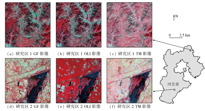
本文在河北省北部山区和南部平原各选择1个10 km×10 km的区域,分别定义为研究区1和研究区2(具体位置见图1)。根据研究区特点,将研究文中所用遥感数据包括Landsat8 OLI,Landsat5 TM以及高分一号,为方便描述,将其分别简写为OLI,TM和GF1。其中OLI所用数据为波段1—7和9,其空间分辨率为30 m; TM所用数据为波段1—5和7,其空间分辨率为30 m; GF1所用数据为波段6—9,其空间分辨率为16 m。
图1
此外,研究区对应的数字高程模型(digital elevation model,DEM)数据及其衍生产品坡度数据经过转投影及重采样,将其分辨率与对应遥感数据保持一致后也用于后续的分类。以上数据均从地理空间数据云获取。
另外,为了对分类结果进行精度评价,本文结合谷歌影像选择验证样本数据,各类别验证样本数量均不少于50个,其中研究区1各类别验证样本数量分别为建设用地50个、耕地150个、林地150个,研究区2各类别为建设用地50个、水体70个、耕地200个。
2 研究方法
2.1 分割参数及特征设置
2.2 分类器
据统计[18],研究中常用的分类器主要包括最近邻法、支持向量机(support vector machine,SVM)、随机森林(random forest,RF)、决策树(decision tree,DT)和朴素贝叶斯(naive Bayes,NB)和最大似然法。本文对eCognition软件中内置的4种分类器进行研究,即: SVM,RF,DT和NB。
SVM通过构建最优超平面使样本空间中任意类别之间的距离最大,从而达到不同类别的区分。在SVM中最优超平面可以通过不同核函数来实现,本研究中选择常用的径向基函数作为核函数[21-22]。径向基函数中有2个参数: C和gamma,其中C是误差惩罚因子,该值影响所训练模型的推广能力,gamma则主要影响最优超平面的形状。本文将C和gamma的值分别设置为10-1, 100, 101, 102, 103, 104, 105, 106, 107, 108和10-5, 10-4, 10-3, 10-2, 10-1, 100, 101, 102, 103, 104,以此来研究这2个参数的变化对SVM性能的影响。
NB是一种基于贝叶斯定理的经典概率分类器。其假定用于判断类别的特征是相互独立的,根据训练样本计算特征的均值和方差,然后用于分类。该分类器不需要设置参数。
另外,文中各分类结果的优劣通过总体精度[25]来进行评价。
3 结果及分析
3.1 不同分类器分类结果比较
图2

图2
研究区1各数据4种分类器结果
Fig.2
Classification results of 4 classifiers for each images in study area-1
图3
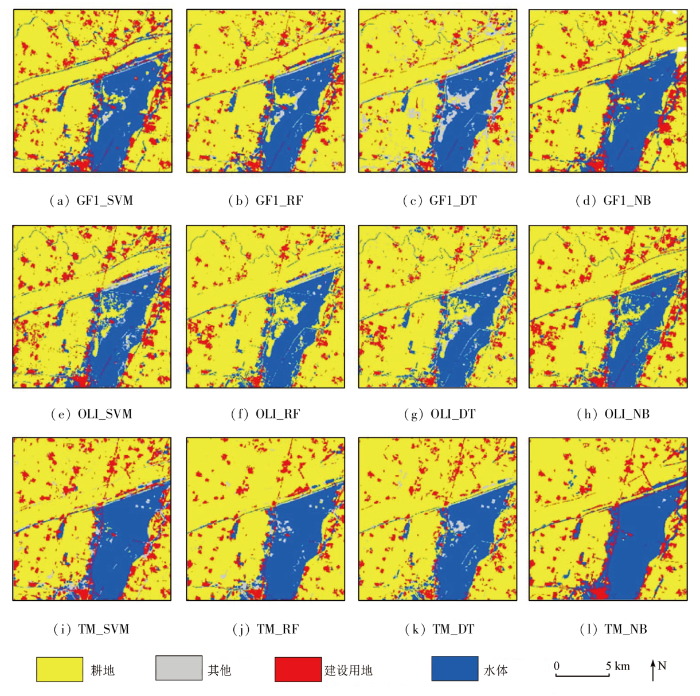
图3
研究区2各数据4种分类器结果
Fig.3
Classification results of 4 classifiers for each image in study area-2
表1 研究区各数据分类结果总体精度
Tab.1
| 分类器 | 研究区1 | 研究区2 | ||||||
|---|---|---|---|---|---|---|---|---|
| OLI | TM | GF1 | 平均值 | OLI | TM | GF1 | 平均值 | |
| SVM | 98.00 | 96.00 | 98.00 | 97.33 | 99.06 | 98.13 | 97.19 | 98.13 |
| RF | 97.43 | 94.86 | 96.00 | 96.10 | 96.56 | 99.06 | 96.56 | 97.39 |
| DT | 92.57 | 88.00 | 93.43 | 91.33 | 95.31 | 96.56 | 91.56 | 94.48 |
| NB | 97.71 | 97.43 | 98.00 | 97.71 | 95.94 | 98.13 | 96.56 | 96.88 |
从表1中可以看出: 在研究区1,OLI数据总体精度从大到小所对应分类器依次为SVM(98.00%),NB(97.71%),RF(97.43%)和DT(92.57%); TM数据的精度依次为NB(97.43%),SVM(96.00%),RF(94.86%)和DT(88.00%); GF1数据分类结果中SVM和NB最优(均为98.00%),RF次之(96.00%),DT最差(93.43%)。在研究区2,OLI数据分类结果的优劣排序依次为SVM(99.06%),RF(96.56%),NB(95.94%)和DT(95.31%); TM数据分类结果中RF最优(99.06%),SVM和NB次之(98.13%),DT最差(96.56%); GF1数据分类结果中SVM最优(97.19%),RF和NB次之(96.56%),DT最差(91.56%)。总体上来看,SVM结果最优,其次是NB和RF,DT在所有情况下都是最差。
3.2 参数对分类器的影响
图4
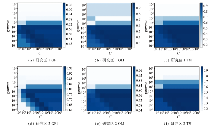
图4
SVM随参数C和gamma变化的分类精度
Fig.4
Overall accuracy of SVM with different values of C and gamma for each image
表2 各数据3种分类器最优参数
Tab.2
| 分类器 | 研究区1 | 研究区2 | ||||
|---|---|---|---|---|---|---|
| OLI | TM | GF1 | OLI | TM | GF1 | |
| SVM(C,gamma) | (106,10-5) | (103,10-3) | (102,10-3) (101,10-2) | (102,10-2) | (103/104/ 105/106/107 /108,10-2) | (105,10-5) (104,10-4) |
| RF(AV,MTN) | (1,400) | (7,500) | (1,100/300/400) (2,350) | (14,300) | (1/4,350) | (2,350/450) |
| DT(Depth) | 4 | 3 | 9/13/15 | 5/7/10/13/14 | 3/8/15 | 3/11/15 |
图5为RF随参数变化的分类结果。其中,研究区1中GF1,OLI及TM的总体精度变化范围分别为91.71%~96%(图5(a)),93.14%~97.43%(图5(b))和87.71%~94.86%(图5(c))。研究区2中GF1,OLI及TM的总体精度变化范围分别为90.63%~96.56%(图5(d)),94.06%~96.56%(图5(e))和89.38%~99.06%(图5(f))。从图5可以看出,RF随参数不同其总体精度变化较小,且其总体精度随参数的变化没有明显的规律。从最优参数(表2)来看,对于AV,除了研究区2的OLI数据,其余情况下AV的值均不大于7; 对于MTN,除了研究区1中GF1数据存在100的情况,其余情况下MTN的值均不小于300。总的来说,参数AV较小、MTN较大时,RF的总体精度较高。
图5-1

图5-1
RF随参数AV和MTN变化的分类精度
Fig.5-1
Overall accuracy of RF with different values of AV and MTN for each image
图5-2

图5-2
RF随参数AV和MTN变化的分类精度
Fig.5-2
Overall accuracy of RF with different values of AV and MTN for each image
图6为DT随参数变化的结果。其中,研究区1中GF1,OLI及TM的总体精度变化范围分别为42.86%~93.43%,14.29%~92.57%和43.14%~88%。研究区2中GF1,OLI及TM的总体精度变化范围分别为35.63%~91.56%,21.25%~95.31%和62.19%~96.56%。
图6
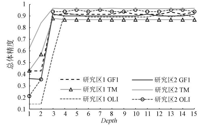
图6
DT随参数Depth变化的分类精度
Fig.6
Overall accuracy of DT with increasing maximum Depth values for each image
4 讨论与结论
4.1 讨论
4.2 结论
本文在河北省北部山区和南部平原选择试验区,以OLI,TM及GF1等3种遥感数据为例,对面向对象土地覆盖分类时不同分类器及其参数设置对分类精度的影响进行了研究,研究结果可以为面向对象的土地覆盖分类提供借鉴。主要结论包括:
1)对于所选4种分类器,OLI,TM及GF1等3种数据在研究区1中各分类器精度的优劣顺序分别为SVM > NB > RF > DT,NB > SVM > RF > DT和SVM = NB > RF > DT; 研究区2中对应的优劣顺序依次为: SVM > RF > NB > DT,RF > SVM = NB > DT和SVM > NB = RF > DT。从整体来看,SVM的表现最好,NB和RF次之,DT的表现最差。
2)从参数设置来看,对于SVM,当C值取值较大且gamma取值较小时,其能够取得较好的分类精度; 当参数C取值不小于103,gamma不大于10-1时,SVM在所有情况下的分类精度均优于90%。对于RF,其分类效果随参数变化的波动较小,从最优分类精度来看其对应的参数AV相对较小,而MTN相对较大。对于DT,当参数Depth大于3时,其在所有情况下能够取得稳定且更好的分类精度。
本文仅对4种分类器进行了分析,后续将进一步对更多分类器开展相关工作。随着高空间分辨率遥感数据的逐步普及和推广应用,建议在条件允许时采用高分辨率遥感数据对本文的研究结果进一步验证。
参考文献
基于时空谱特征的墨脱县森林分类方法与实现
[J].
Forest classification for Motuo County:A method based on spatio - temporal - spectral characteristics
[J].
基于多时相遥感植被指数的柑橘果园识别
[J].
Identification of citrus orchard under vegetation indexes using multi-temporal remote sensing
[J].
雅砻江中上游流域生态环境脆弱性动态评价及预测
[J].
Dynamic evaluation and prediction of ecological environment vulnerability in the middle-upper reaches of the Yalong River
[J].
基于高分光学卫星影像的泸定地震型滑坡提取与分析
[J].
The extraction and analysis of Luding earthquake-induced landslide based on high-resolution optical satellite images
[J].
基于遥感影像的震后避难空间快速提取模型研究——以2021年云南漾濞M_S6.4地震为例
[J].
Study on the rapid extraction model of post-earthquake shelter sites based on remote sensing images:A case study of the Yangbi MS6.4 Earthquake
[J]
基于Landsat8遥感数据的西沙永乐环礁底质分类与变化分析
[J].
Classification and change analysis of the substrate of the Yongle Atoll in the Xisha Islands based on Landsat8 remote sensing data
[J].
GF-2影像城市地物分类方法探讨
[J].
DOI:10.13474/j.cnki.11-2246.2019.0210
[本文引用: 1]

GF-2影像具有较高的分辨率和丰富的光谱、几何及纹理信息。为了深入探索GF-2影像城市地物分类方法,本文以四川省隆昌县城为研究区,提出了一种基于最优尺度和规则的面向对象分类法。在影像分割的基础上,通过构建评价函数,并结合最大面积法选取最优尺度,进而构建分层体系,提取影像的光谱、几何及纹理特征建立规则并分类,且将其与单尺度下的面向对象和基于像素分类法进行对比分析。结果表明,本文方法的总体精度和Kappa系数分别为93.33%和0.92。
Discussion on classification methods of urban features based on GF-2 images
[J].
DOI:10.13474/j.cnki.11-2246.2019.0210
[本文引用: 1]
The GF-2 image has higher resolution as well as more detailed characteristics of spectral, features, geometric and texture. In order to explore the classification method of the GF-2 image in urban features, an object oriented classification method based on optimal scale and rules is proposed in the study area of Longchang County, Sichuan Province. Based on segmentations, the evaluation function is constructed, combining with the maximum area method, optimal segmentation scales are selected to construct multiple layers. The spectral, geometric and texture features of the image are extracted to establish rules for classification and compared with the classification methods of object-oriented with the single scale and pixel based. The results show that the overall accuracy and Kappa coefficient of the proposed method are 93.33% and 0.92, respectively.
基于无人机遥感的高潜水位采煤沉陷湿地植被分类
[J].
Vegetation classification by using UAV remote sensing in coal mining subsidence wetland with high ground-water level
[J].
Per-pixel vs.object-based classification of urban land cover extraction using high spatial resolution imagery
[J].
以SPOT5遥感数据为例比较基于像素与面向对象的分类方法
[J].
Taking SPOT5 remote sensing data for example to compare pixel-based and object-oriented classification
[J].
复杂环境下GF-2影像水体指数的构建及验证
[J].
The construction and verification of a water index in the complex environment based on GF-2 images
[J].
基于不同决策树的面向对象林区遥感影像分类比较
[J].
DOI:10.13287/j.1001-9332.201812.015
[本文引用: 1]
面向地理对象影像分析技术(GEOBIA)是影像分辨率越来越高的背景下的产物.如何提高高分辨率影像分类精度和分类效率是影像处理的重要议题之一.本研究对QuickBird影像多尺度分割后的对象进行分类,分析了C5.0、C4.5、CART决策树算法在林区面向对象分类中的效率,并与kNN算法的分类精度进行比较.利用eCognition软件对遥感影像进行多尺度分割,分析得到最佳尺度为90和40.在90尺度下分离出植被和非植被后,在40尺度下提取不同类别植被的光谱、纹理、形状等共21个特征,并利用C5.0、C4.5、CART决策树算法分别对其进行知识挖掘,自动建立分类规则.最后利用建立的分类规则分别对植被区域进行分类,并比较分析其精度.结果表明: 基于决策树的分类精度均高于传统的kNN法.其中,C5.0方法的精度最高,其总体分类精度为90.0%,Kappa系数0.87.决策树算法能有效提高林区树种分类精度,且C5.0决策树的Boosting算法对该分类效果具有最明显的提升.
Comparison of object-oriented remote sensing image classification based on different decision trees in forest area
[J].
光谱模型结合面向对象法的山区水体提取
[J].
Water extraction in mountainous area based on spectral model and object-oriented method
[J].
融入超像素分割的高分辨率影像面向对象分类
[J].
DOI:10.13474/j.cnki.11-2246.2021.0174
[本文引用: 1]
针对高分辨率遥感影像面向对象分类中容易受分割参数的影响、分类精度不稳定的问题,本文提出了一种融入超像素分割的高分辨率影像面向对象分类方法。该方法通过简单线性迭代聚类(SLIC)算法对原始影像进行聚类生成超像素影像,并在此基础上采用分形网络演化方法(FNEA)进行多尺度分割生成同质性对象,最后利用最邻近分类方法进行地物分类。试验结果表明,该方法不易受多尺度分割参数的影响,分类效果稳定,而且分类精度明显高于传统的面向对象分类方法,对于高分辨率遥感影像的广泛应用具有重要意义。
Object-oriented classification of high-resolution image combining super-pixel segmentation
[J].
DOI:10.13474/j.cnki.11-2246.2021.0174
[本文引用: 1]
In order to solve the problem that high-resolution remote sensing image object-oriented classification is easy to be affected by segmentation parameters and the classification accuracy is not stable, this paper proposes an object-oriented classification of high-resolution image combining super-pixel segmentation. In this method, a simple linear iterative clustering algorithm is used to cluster the original image to generate the super-pixel image. On this basis, the fractal net evolution approach is used for multi-scale segmentation to generate homogeneous objects. Finally, the nearest neighbor classification method is used to classify the ground objects. The experimental results show that the method is not easily affected by multi-scale segmentation parameters, the classification effect is stable, and the classification accuracy is significantly higher than that of the traditional object-oriented classification method, which is of great significance for the wide application of high-resolution remote sensing images.
基于弱监督语义分割的灯盏花无人机遥感种植信息提取
[J].
Extraction of erigeron breviscapus planting information by unmanned aerial vehicle remote sensing based on weakly supervised semantic segmentation
[J].
Effects of training samples and classifiers on classification of Landsat8 imagery
[J].
A Review of supervised object based land-cover image classification
[J].
Comparing machine learning classifiers for object-based land cover classification using very high resolution imagery
[J].
Object-based image analysis of suburban landscapes using Landsat8 imagery
[J].
A multi-verse optimizer approach for feature selection and optimizing SVM parameters based on a robust system architecture
[J].
基于PSO参数优化支持向量机的湿地遥感分类——以鄱阳湖部分区域为例
[J].
Remote sensing classification of Poyang Lake wetland based on PSO parameter optimized support vector machine
[J].
Training set size,scale,and features in geographic object-based image analysis of very high resolution unmanned aerial vehicle imagery
[J].
基于超像素统计量的随机森林遥感图像分类
[J].
Research on random forest remote sensing image classification based on superpixel statistics
[J].
基于多源数据的南方丘陵山地土地利用随机森林分类
[J].
Random forest classification of land use in hilly and mountaineous areas of southern China using multi-source remote sensing data
[J].
