

0 引言
极地冰盖物质平衡对于全球海平面上升具有重要的影响,是预测未来全球海平面上升的最大不确定性来源[1]。冰面消融是造成极地冰盖物质损失的重要原因。每年消融期,格陵兰冰盖与南极冰盖表面消融产生大量冰面融水,融水在地形等因素作用下汇集至低洼处形成冰面湖[2-3]。冰面湖广泛分布于极地冰盖表面,能够存储大量冰面融水,进而影响冰盖水文过程[4]。其中,部分冰面湖存储大量融水后,湖底破裂并输送冰面融水进入冰盖内部甚至底部,减小冰盖运动阻力,进而影响冰盖运动速度与稳定性[5-6]。因此,准确测算冰面湖水深信息,进而估算冰面湖体积及其动态变化,对于更好地理解极地冰盖水文过程及其影响、准确揭示冰盖物质平衡与稳定性具有重要意义。
近年来,遥感技术已经广泛应用于冰面湖水深反演,遥感反演的基本原理是建立多波段光学遥感影像反射率与实测水深值之间的定量关系。Fitzpatrick等[10]基于Box等[7]的实测水深数据和MODIS遥感影像反演了格陵兰冰盖西部冰面湖水深; Legleiter等[9]利用实测水深数据建立了适用于WorldView2遥感影像的格陵兰冰盖融水深度反演经验公式; Pope等[11]基于Tedesco等[8]的实测水深数据结合Landsat8影像建立了格陵兰冰面湖水深反演经验公式。然而,实测水深数据数量十分有限,难以推广到长时序的冰面湖水深遥感反演。近年来,有研究使用汇水前和排水后的干涸冰面地形洼地计算冰面湖水深,作为实测水深数据的替代。Moussavi等[12]利用WorldView数字地形模型提取干涸地形洼地信息,与冰面湖轮廓相交获取冰面湖水深,进而建立了冰面湖水深反演经验公式。
ICESat-2 (Ice, Cloud, and land Elevation Satellite-2)卫星于2018年发射,激光雷达穿透性强、精度高且数据覆盖范围广,激光波束能够穿透水体并被水面和水底反射,反演浅海水深(<30 m)精度较高,均方根误差(root mean square error,RMSE)均在最大水深的10%以内[13⇓-15]。最近几年,ICESat-2已开始被用于极地冰盖冰面湖水深(<15 m)反演。Fair等[16]利用ICESat-2激光测高数据反演冰面湖水深,发现水深遥感反演误差为0.12~0.80 m。Fricker等[17]同样基于ICESat-2激光测高数据反演了南极冰盖东部Amery冰架冰面湖水深,结果显示其精度高于基于光学遥感影像的水深反演方法。
ICESat-2仅能提供沿着激光点云轨迹的冰面湖剖面水深反演结果,为了进一步反演整个冰面湖的水深,需要综合光学卫星遥感影像与ICESat-2激光测高数据。目前,此类研究通常聚焦于中等空间分辨率(10~30 m)光学卫星遥感影像数据,水深反演结果精度有限、分辨率不足。以PlanetScope为代表的光学小卫星遥感影像则兼具高时空分辨率(理想情况下重访周期约1 d,空间分辨率3 m),并且可以免费获取。目前,PlanetScope遥感影像已开始初步应用于冰面湖相关研究。Qayyum等[18]利用PlanetScope遥感影像和深度学习算法提取冰面湖轮廓遥感信息,提取的冰面湖数量显著多于同期Landsat OLI影像提取结果,这说明PlanetScope影像较高的时空分辨率在冰面湖监测中具有显著优势; Datta等[19]基于ICESat-2数据和PlanetScope Dove-R 4波段遥感影像,利用红光和绿光波段初步反演了格陵兰冰盖西部冰面湖水深,然而并未分析PlanetScope水深反演的最佳波段组合。
2020年3月起,PlanetLabs公司开始发布PlanetScope SuperDove光学小卫星8波段影像,这一影像在PlanetScope Dove-R小卫星4波段遥感影像的基础上新增了4个波段,并且通过Sentinel-2基准影像进行了辐射校正,数据质量显著提升[20]。本研究利用PlanetScope SuperDove光学小卫星8波段影像,探索各个波段在冰面湖水深反演方面的潜力,综合PlanetScope小卫星8波段地表反射率遥感影像与ICESat-2激光测高数据,选取了4个位于格陵兰冰盖东北部的冰面湖,使用自适应核密度估计自动化分离并拟合ICESat-2数据湖面与湖底点云,进而获取冰面湖水深观测结果,再结合同时期PlanetScope影像各波段光谱反射率,利用最佳波段比值分析比较不同波段与ICESat-2水深数据的相关关系,选取适用于水深反演的最佳波段,构建并应用水深反演经验公式。
1 研究区概况及数据源
1.1 研究区概况
本研究选择格陵兰冰盖东北部作为研究区,选择该区域内4个冰面湖作为研究对象(图1)。
图1
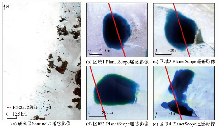
图1
研究区Sentinel-2遥感影像及局部区域PlanetScope遥感影像
Fig.1
Remote sensing images of study area and PlanetScope images of local areas
1.2 数据源
研究选用由Planet Labs公司生产并发布的PlanetScope SuperDove Level 3B地表反射率(surface reflectance,SR)数据产品,该数据经过传感器校正、以Sentinel-2遥感影像为基准的辐射校正和正射校正[20],进一步基于6S辐射传输模型和MODIS近实时数据完成了大气校正,具有海岸带蓝光(B1,431~452 nm)、蓝光(B2,465~515 nm)、绿光Ⅰ(B3,513~549 nm)、绿光Ⅱ(B4,547~583 nm)、黄光(B5,600~620 nm)、红光(B6,650~680 nm)、红边(B7,697~713 nm)与近红外(B8,845~885 nm)8个波段,空间分辨率为3 m。研究选用2021年7月4景云量较少的PlanetScope遥感影像(表1)。
表1 研究数据列表
Tab.1
| 区域编号 | 数据获取时间 | ICESat-2数据编号 | PlanetScope影像编号 |
|---|---|---|---|
| 1 | 2021-07-20 | 20210720053125_04061205_005_01 | 20210720_135021_19_2455 |
| 2 | 20210720_144349_03_2405 | ||
| 3 | 20210720_133408_92_242d | ||
| 4 | 20210720_133408_92_242d |
ICESat-2是专用于测量极地冰盖的卫星[23],发射于2018年9月,是美国继ICESat后发射的新一代星载激光雷达卫星,搭载了先进的地形激光测高系统(advanced topographic laser altimeter system,ATLAS)。ICESat-2/ATLAS采用多波束微脉冲激光器,共有6个不同的激光波束,分别为3对强弱激光波束(强弱能量比约为4:1): GT1L/R,GT2L/R和GT3L/R[24]。不同激光波束沿垂直轨道方向平行排列,2对激光波束之间距离约3.3 km,每对强弱激光波束之间相距为90 m,以高频率(10 kHz)发射绿色(532 nm)激光脉冲,在清澈水域中探测深度可达到40 m[25],具备代替实地测量水深的能力[26]。ICESat-2的轨道高度为500 km,轨道倾角约92°,沿轨道大约每0.7 m记录一个激光脉冲,ICESat-2能够记录每个返回卫星的光子的时间与坐标[27]。同时,ICESat-2数据覆盖全球,因此适用于极地等难以实地测量水深真值的区域[28]。
研究采用ICESat-2 ATLAS的ATL03和ATL06数据,ATL03数据是全球地理定位光子数据,ATL06数据是3A级陆地冰高程数据。ATL03数据经过了必要的地球物理校正过程,包括地球固体潮汐校正和海洋潮汐校正等[29]。Yuan等[30]通过ICESat-2激光测高数据和水位观测数据研究了中国面积大于10 km2的湖泊和水库,结果显示ICESat-2数据的相对测高误差为0.06 m,说明ICESat-2测高数据精度较高。ATL03数据提供生产3A级数据产品的所有光子的经纬度与高程信息,ATL06数据由ATL03数据处理得到,利用ATL03识别的信号光子数据,以20 m为固定间隔沿轨生产陆地表面冰高程数据,以40 m范围内信号光子数据中值生成高程[31]。研究通过美国冰雪数据中心网站(
2 研究方法
2.1 ICESat-2冰面湖水深拟合方法
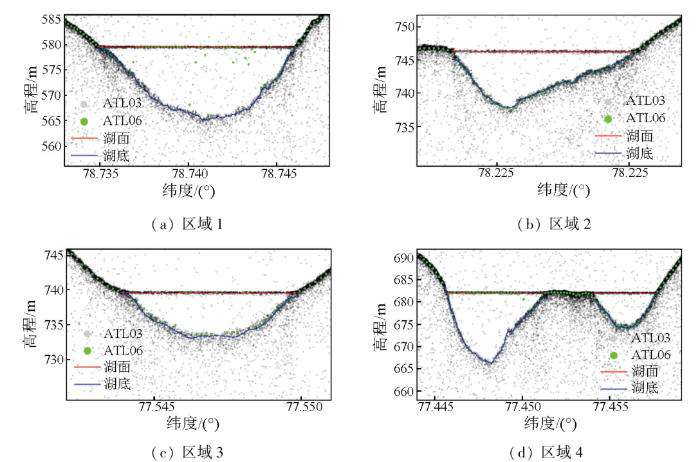
研究以ICESat-2 ATL03和ATL06光子数据为输入,利用自适应核密度估计算法自动化输出冰面湖湖面和湖底高程[19]。首先,去除高于1 500 m的点,根据ATL06的光子点云高程筛选其上下50 m范围内的ATL03光子点。以每75个ATL03光子点作为集合,获取3个具有最大概率密度的高度值,分别为冰面湖表面高程、冰面湖湖底高程和一个可能为湖面下冰的高程。再次,以每5 000个ATL03光子点作为集合,去除异常值,进行平滑、滤波等操作,判断冰面湖表面特征(例如是否存在浮冰)。最后,采用Parrish等[26]的方法完成折射校正,获得冰面湖湖面和湖底的高程估算结果,计算两者高程差作为最终的冰面湖水深数据。ICESat-2 ATL03光子点云数据沿轨间隔约0.7 m,PlanetScope遥感影像空间分辨率为3 m,因此对每个遥感影像像元范围内所有光子点计算得到的水深取平均值,作为该像元对应的水深数据。以水深1 m为间隔对所有水深数据分层抽样,抽取70%作为训练数据,剩余30%作为验证数据。
2.2 PlanetScope水深反演经验公式建立
研究选用统计经验模型,通过建立PlanetScope遥感影像光谱反射率和ICESat-2水深数据之间的回归关系反演冰面湖水深。水深反演模型的表达形式选择幂函数、指数函数、二次函数和对数函数。为了基于遥感影像光谱特征建立水深反演模型,需要选择适当的光谱波段,由于不同波段及波段组合对水深响应的敏感程度不同,利用最佳波段比值分析(optimal band ratio analysis,OBRA)选取最佳波段(组合)。将N个光谱波段对应的反射率两两组合取比值(Bx/By),得到遥感影像所有可能的波段组合比值。由于波段比值结果值域较大,所以计算其对数,取对数后能够缩小数据的绝对数值,方便后续计算,同时不会改变数据的性质和相对关系,最终以ln(Bx/By)和单波段反射率作为X。分别建立水深数据与X的回归模型并计算决定系数R2,用于评估回归模型的拟合优度。因为X是OBRA回归中唯一的自变量,所以唯一影响回归模型拟合结果的就是不同波段(组合)的选取,故拟合结果最高R2的X是最佳波段(组合)。OBRA可以根据不同的数据集选择最适宜建立水深反演模型的波段(组合)。最终基于最佳波段(组合)建立水深反演经验公式,并利用该公式预测验证样本的水深,计算预测水深和ICESat-2水深数据的RMSE和相对均方根误差(relative root mean squared error,RRMSE),评价所得水深反演经验公式的精度。
3 结果与分析
由ICESat-2数据拟合的冰面湖剖面结果可知(图2),冰面湖湖面和湖底处光子点云密度较大,明显区分于背景光子点云,拟合的冰面湖湖面和湖底结果呈现为较平滑的曲线,并且基本符合ICESat-2 ATL03光子点云的分布,能够反映冰面湖湖面和湖底的高程,可以清晰地表现出冰面湖水深的变化。研究选用的4个湖泊内共获得1 355组样本数据,其中ICESat-2水深数据最大值约为15.7 m,具有一定代表性。
图2
研究利用OBRA确定最佳波段(组合),分别计算不同波段(组合)水深反演经验公式拟合结果R2并绘制热力图(图3),结果显示,绿光波段在4种函数模型中均与ICESat-2水深数据具有很强的相关性。红光在水中比绿光和蓝光衰减速率更快,因此,对于相同的湖深变化,红光波段的遥感影像光谱反射率变化比绿光和蓝光波段的变化更大。然而,红光波段由于衰减迅速,仅在较浅的湖泊深度范围内与水深数据相关性较强,红光波段适用于水深反演的最大湖泊深度约为5 m[11]。研究选取的湖泊最深处约15.7 m,超出了红光波段的适用范围,而绿光、蓝光波段及其与海岸带波段的组合和水深数据表现出较强的相关性,其中,绿光I波段与ICESat-2水深数据在指数函数模型中相关性最强(R2=0.94),因此确定绿光I波段为本研究中用于建立水深反演模型的最佳波段。
图3
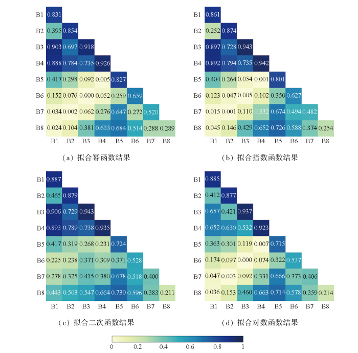
图3
不同波段(组合)拟合经验公式结果R2对比
Fig.3
R2 results of empirical formulae fitted to different bands
研究选取绿光Ⅰ波段与水深数据,利用足够数量的样本点建立指数函数作为冰面湖水深反演经验公式,计算得到验证样本(水深<15.7 m)中水深数据和绿光Ⅰ波段反射率的相关性很强(R2=0.94),RMSE=1.0 m,RRMSE=0.15,误差较小(图4),与已有研究相当(RMSE低于最大水深的10%),说明结合高空间分辨率PlanetScope遥感影像与ICESat-2数据,利用OBRA选取最佳波段,建立函数模型,能够得到精度较高的冰面湖水深反演经验公式。
图4
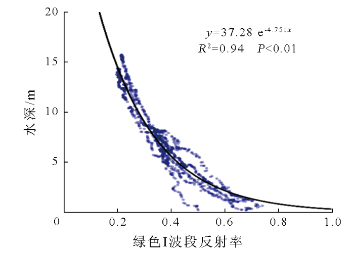
图4
冰面湖水深反演经验公式拟合结果
Fig.4
Results of fitting the empirical formula for supraglacial lake bathymetry estimation
Datta等[19]利用单个冰面湖范围中的ICESat-2光子点云数据,结合对应的影像光谱值建立了独立的水深经验公式。本研究综合利用了4个冰面湖中的数据,建立了一个共同的冰面湖水深反演经验公式,用于建立水深反演模型的样本点数量更多,建立的水深反演经验公式更为可靠。
研究将冰面湖水深反演经验公式应用于区域3和区域4所在的一景PlanetScope遥感影像范围内,反演该区域内冰面湖水深,结果显示(图5)区域内冰面湖水深介于1.3~18.3 m之间,计算得到总体积约为0.10 km3。由此可见,可以通过本文构建的冰面湖水深反演经验公式测算冰面融水存储量,尤其是考虑到PlanetScope遥感影像的高重访观测次数,后续研究可以进一步分析冰面融水储量的动态变化,从而提升对冰面水文过程的理解。然而,本文提出的综合主被动卫星数据的方法仅能反演冰面开放水体对应的深度,无法观测到被浮冰覆盖的水体部分(图5),因此遥感反演得到的冰面湖总体积低于实际冰面湖总体积,这一问题后续可以通过数字地形模型模拟干涸冰面地形洼地予以解决。
图5
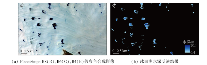
图5
PlanetScope遥感影像及其反演结果
Fig.5
PlanetScope image and result of supraglacial lake bathymetry estimation
4 结论
本研究使用ICESat-2激光测高点云数据,自动化分离并拟合冰面湖湖面与湖底点云,进而获取冰面湖水深观测结果,然后利用同时期高空间分辨率(3 m)PlanetScope光学小卫星多波段地表反射率遥感影像,分析不同波段(组合)与ICESat-2水深数据的相关关系,选取最佳波段(组合)建立水深反演经验公式。主要结论如下: PlanetScope遥感影像绿光Ⅰ波段与水深数据之间相关性最强(R2=0.94),基于该波段以指数函数为模型建立的水深反演经验公式精度较高(RMSE=1.0 m,RRMSE=0.15)。总结来说,结合高空间分辨率PlanetScope遥感影像与ICESat-2数据,利用OBRA对比PlanetScope不同波段拟合经验公式结果选取最佳波段(组合),建立函数模型,能够得到精度较高的冰面湖水深反演经验公式。研究揭示了综合主被动卫星数据分析极地冰盖水文过程的良好潜力。
参考文献
The land ice contribution to sea level during the satellite era
[J].
格陵兰冰盖表面消融研究进展
[J].
DOI:10.7522/j.issn.1000-0240.2013.0012
[本文引用: 1]

冰盖表面消融是格陵兰冰盖物质平衡的重要组成部分, 已成为近年来格陵兰冰盖研究的热点. 格陵兰冰盖表面消融研究的关键在于理解冰盖融水的产生、 运移和释放等水文过程, 需要解决如下关键科学问题: 1) 冰盖表面产生了多少融水;2)冰盖表面水文系统具有什么特征; 3)冰盖表面融水如何影响冰盖运动; 围绕这些科学问题, 总结了格陵兰冰盖表面消融的研究进展. 冰盖表面消融建模、 冰盖表面湖的信息提取与面积特征变化、 深度反演与体积量算等是目前研究冰盖表面融水量的主要途径, 冰盖表面湖、 冰盖表面径流、 锅穴与冰裂隙等表面水文要素的空间分布规律研究则可用于揭示冰盖表面水文系统特征, 冰盖表面融水与冰盖运动速率的关系、 表面融水进入冰盖内部与底部的水文过程是目前揭示表面融水如何影响冰盖运动的主要手段.
The progress of Greenland Ice Sheet surface ablation research
[J].
DOI:10.7522/j.issn.1000-0240.2013.0012
[本文引用: 1]
Surface ablation has great impact on the Greenland Ice Sheet (GrIS) mass balance and becomes the focus of GrIS research in recent years. The production, transportation and release of meltwater are the keys to understand the potential impact of the GrIS surface ablation. These hydrological processes could illustrate the following problems: How much meltwater is produced atop the GrIS? What are the characteristics of meltwater-formed supraglacial hydrological system? How does the meltwater influence the GrIS motion? Ablation modeling is an important approach to acquire surface ablation information. Areas, depths, and volumes of supraglacial lakes extracted from remotely sensed imageries provide direct meltwater information. The spatial distribution of supraglacial lakes, supraglacial streams, moulins and crevasses demonstrates the characteristics of supraglacial hydrological system, which is in charge of meltwater transportation. The release of meltwater into englacial and subglacial ice sheet has important but undetermined impact on the GrIS motion. The relationship between surface meltwater volume and GrIS motion velocity is employed to understand the impact.
Seasonal evolution of supra-glacial lakes on the Greenland Ice Sheet
[J].
冰川表面水文过程研究进展
[J].
DOI:10.7522/j.issn.1000-0240.2016.0194
[本文引用: 1]
冰面水文过程是冰川径流过程的重要组成部分,对于冰川运动与物质平衡具有重要影响。冰川表面在太阳辐射、冰川物理性质、冰面地形和成冰带空间分布等多种因素影响下消融,形成以冰面水系为主线,锅穴、冰裂隙、冰面湖等为端点的冰面融水输送与分配体系。深入理解冰面水文过程,掌握冰川表面融水的输送、存储与释放,对于研究短时间尺度的冰川融水径流过程、探索冰川动态响应机理具有重要意义。总结回顾了目前国内外冰面水文过程的研究现状,提出了该领域有待解决的主要科学问题。
Supraglacial drainage system:A review
[J].
Greenland supraglacial lake drainages triggered by hydrologically induced basal slip
[J].
Rapid accelerations of An-tarctic Peninsula outlet glaciers driven by surface melt
[J].
DOI:10.1038/s41467-019-12039-2
PMID:31541114
[本文引用: 1]
Atmospheric warming is increasing surface melting across the Antarctic Peninsula, with unknown impacts upon glacier dynamics at the ice-bed interface. Using high-resolution satellite-derived ice velocity data, optical satellite imagery and regional climate modelling, we show that drainage of surface meltwater to the bed of outlet glaciers on the Antarctic Peninsula occurs and triggers rapid ice flow accelerations (up to 100% greater than the annual mean). This provides a mechanism for this sector of the Antarctic Ice Sheet to respond rapidly to atmospheric warming. We infer that delivery of water to the bed transiently increases basal water pressure, enhancing basal motion, but efficient evacuation subsequently reduces water pressure causing ice deceleration. Currently, melt events are sporadic, so efficient subglacial drainage cannot be maintained, resulting in multiple short-lived (<6 day) ice flow perturbations. Future increases in meltwater could induce a shift to a glacier dynamic regime characterised by seasonal-scale hydrologically-driven ice flow variations.
Remote sounding of Greenland supraglacial melt lakes:Implications for subglacial hydraulics
[J].
In-situ multispectral and bathymetric measurements over a supraglacial lake in western Greenland using a remotely controlled watercraft
[J].
Mapping the bathymetry of supraglacial lakes and streams on the Greenland ice sheet using field measurements and high-resolution satellite images
[J].
A decade (2002—2012) of supraglacial lake volume estimates across Russell Glacier,West Greenland
[J].
Estimating supraglacial lake depth in West Greenland using Landsat 8 and comparison with other multispectral methods
[J].
Derivation and validation of supraglacial lake volumes on the Greenland Ice Sheet from high-resolution satellite imagery
[J].
A semi-empirical scheme for bathymetric mapping in shallow water by ICESat-2 and Sentinel-2:A case study in the South China Sea
[J].
Nearshore bathymetry from fusion of Sentinel-2 and ICESat-2 observations
[J].
DOI:10.1109/LGRS.2020.2987778
[本文引用: 1]
Nearshore estimates of bathymetry are crucial for understanding coastal processes. However, current passive remote sensing methods for estimating bathymetry require in situ depth measurements to train inversion models, which can be difficult or impossible to obtain in many areas. To address this issue, we investigated the fusion of range measurements from the advanced topographic laser altimeter system (ATLAS) aboard the NASA ICESat-2 satellite, and multispectral satellite imagery from European Space Agency (ESA) Sentinel-2 using two common bathymetric inversion algorithms. The active ranging capability of the ATLAS green (532-nm) laser has been shown to generate returns of up to 38-m depth in optically clear waters, providing depth measurements to constrain passive bathymetric inversion results. Data acquired in November 2018 over the nearshore in Destin, FL, USA, offer a proof of concept for this approach. The results of the bathymetric inversion were quantitatively assessed by comparison with airborne bathymetric LiDAR collected using the U.S. Army Corps Coastal Zone Mapping and Imaging LiDAR (CZMIL) system in October-November 2018. Overall, the results of the bathymetric inversion compared with the CZMIL data have a root mean square error (RMSE) of 0.35 m in waters with similar turbidity and bottom reflectivity, and demonstrate that a combination of ICESat-2 depth observations with Sentinel-2 multispectral imagery can estimate seamless nearshore bathymetry for optically clear coastal waters.
Deriving highly accurate shallow water bathymetry from Sentinel-2 and ICESat-2 datasets by a multitemporal stacking method
[J].
Using ICESat-2 and Operation IceBridge altimetry for supraglacial lake depth retrievals
[J].
ICESat-2 meltwater depth estimates:Application to surface melt on Amery Ice Shelf,East Antarctica
[J].
Glacial lakes mapping using multi satellite PlanetScope imagery and deep learning
[J].
Supraglacial lake bathymetry automatically derived from ICESat-2 constraining lake depth estimates from multi-source satellite imagery
[J].
A global analysis of the temporal availability of PlanetScope high spatial resolution multi-spectral imagery
[J].
A new ice thickness and bed data set for the Greenland ice sheet:1.Measurement,data reduction,and errors
[J].
Rapid ablation zone expansion amplifies North Greenland mass loss
[J].
The ICESat-2 laser altimetry mission
[J].
ICESat-2 elevation retrievals in support of satellite-derived bathymetry for global science applications
[J].
Evaluation of a statistical approach for extracting shallow water bathymetry signals from ICESat-2 ATL03 photon data
[J].
Validation of ICESat-2 ATLAS bathymetry and analysis of ATLAS’s bathymetric mapping performance
[J].
An active-passive fusion strategy and accuracy evaluation for shallow water bathymetry based on ICESat-2 ATLAS laser point cloud and satellite remote sensing imagery
[J].
A high-resolution bathymetry dataset for global reservoirs using multi-source satellite imagery and alti-metry
[J].
The Ice,Cloud,and Land Elevation Satellite - 2 mission:A global geolocated photon product derived from the Advanced Topographic Laser Altimeter System
[J].
Performance assessment of ICESat-2 laser altimeter data for water-level measurement over lakes and reservoirs in China
[J].
Land ice height-retrieval algorithm for NASA’s ICESat-2 photon-counting laser altimeter
[J].
