

0 引言
土地利用冲突本质是不同利益主体未考虑土地功能性进行不协调使用土地资源而造成人地空间竞争与权益冲突的现象[1]。近年来,国外对土地利用冲突研究主要聚集在土地冲突的来源[2]、类型[3]、识别[4]、演变[5]及管理[6]上。而国内在2001年的“自然资源管理和利用中的冲突管理方法”专题研讨会后学者们给予了土地利用冲突广泛关注,至今已经取得了比较丰硕的成果: 一是土地利用冲突的内涵,阮松涛等[1]认为土地利用冲突本质是不同土地价值在社会上的博弈,是不同利益主体间的博弈,邹利林等[7]认为土地利用冲突主要强调土地资源“利用”这一过程及各个利益相关者所产生的空间及利益冲突[7]; 二是土地利用冲突的研究内容,包括土地利用冲突的理论基础[8]、识别与诊断[9-10]、表现方式与类型[11]、演变机制[12]及缓解[13⇓-15]等,如张潇等[12]借助地理信息系统(geographic information system,GIS)展示长江三角洲近40 a的土地利用冲突时空演变特征并多情景模拟未来冲突演化趋势; 三是土地利用冲突的研究方法,包括博弈法[16]、压力—状态—响应(pressure state response,PSR)模型[17]、多目标适宜性[18]等,如王娟娟等[19]构建土地利用冲突模型、空间自相关及冷热点分析对乌鲁木齐2000—2018年的土地利用冲突格局进行了分析。总体来看,学者们对土地利用冲突进行了大量且深入的研究,但尚存一些可改进的部分: ①研究内容上,基于“三生”功能视角对土地利用冲突优化方面的研究较少; ②研究方法上,采用多目标适宜性评价模型的探索还较少; ③冲突缓解对策上,现有研究往往单一考虑土地适宜性而忽略国土空间自身系统。土地具有多宜性,只有既满足社会经济发展的空间要素保障需求,又能维持国土空间自身系统的健康持续稳定,国土空间才能可持续发展。因此,探析城市 “三生”功能视角下土地利用冲突特征,同时考虑国土空间本底及规划目标进行分区调控,对优化国土空间合理布局、制定科学合理的土地利用对策具有重要意义。
南昌市地理位置优越,从南宋起一直是江西地区的政治、经济及文化中心。近几年,经济和人口的快速增长使得南昌市人地矛盾日益加剧,土地利用冲突亟需缓解。本研究以该市为研究对象,基于生产-生活-生态这一视角,提出适用于南昌市的多目标土地利用适宜性评价方法和土地利用冲突强度诊断模型,评价其“三生”空间适宜性及存在的土地利用冲突情况,并叠加功能分区与土地利用冲突分析结果进行分区识别与差别化调控,以期为南昌市及其他类似城市的国土空间合理布局的优化提供经验借鉴。
1 研究区概况及数据源
1.1 研究区概况
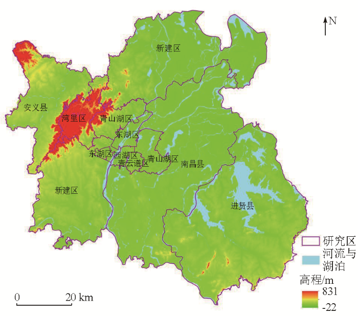
南昌市(处于E115°27'~116°35',N28°10'~29°11')位于江西省偏北位置,下辖6区(东湖区、西湖区、青山湖区、青云谱区、湾里区、新建区)3县(南昌县、安义县、进贤县)(2020年行政区划),是我国唯一一个同时毗邻长三角、珠三角及海峡西岸经济区的省会城市,具体位置见图1所示。随着南昌大都市圈、赣江新区等政策相继出台,红谷滩新区、瑶湖片区等新城的建设,南昌市这几年获得了巨大发展。2000—2020年,南昌市国内生态总值(gross domestic product,GDP)由552.37亿元上升至5 745.51亿元,城镇化率由44.02%上升至78.08%,耕地面积由274 715 hm2下降至274 433.90 hm2,城镇开发与粮食保护矛盾突出。
图1
1.2 数据源及其预处理
研究数据来源主要包括: ①土地利用数据即2020年南昌市第三次全国国土调查数据,来自南昌市自然资源与规划局; ②坡度、坡向等地形数据源自地理空间数据云网站(http://www.gscloud.cn/)的数字高程模型(digital elevation model,DEM)数据; ③基础教育设施、医疗设施等地理坐标数据,从百度地图地理坐标器(http://api.map.baidu.com/lbsapi/getpoint/)下载; ④人均耕地面积、人口密度等社会经济数据源于《江西省统计年鉴》(2021年)、《南昌市统计年鉴》(2021年)。所有空间数据在ArcGIS10.2中统一转换为CGCS 2000坐标,并划分为1 km×1 km栅格,形成7 567个评价单元。
2 研究方法
2.1 多目标适宜性评价模型的构建
2)指标处理、分级赋值及权重确定。根据指标性质与由来进行指标处理与分级赋值: ①坡度、坡向及海拔数据从地理空间数据云下载DEM数据,然后运用ArcGIS10.2的3D分析工具计算得到指标图层,分级赋值后得到因子图层; ②与建设用地的距离、距水体距离、与城镇中心的距离等指标运用解译数据做缓冲区分析,再采用自然断点法分级赋值得到因子图层; ③与教育基础设施的距离、与医疗设施的距离,这2个指标获取后导出至ArcGIS10.2并进行矢量化、缓冲区分析,最终分级赋值得到因子图层; ④景观破碎度、植被归一化指数从Landsat8影像中获取,ENVI4.8预处理得到结果后导入ArcGIS10.2中投影转换后分级赋值得到因子图层; ⑤人均耕地面积、单位耕地面积粮食产量及人口密度根据《南昌市统计年鉴2021年》中基础数据进行计算得到,并运用克里金插值(Kring)[23]实现空间化,分级赋值得到因子图层。
综合比较层次分析法和特尔斐法的结果来确定指标权重,最终结果见表1。
表1 南昌市多目标适宜性评价指标体系与权重表
Tab.1
| 目标层 | 因素层 | 指标 | 因子分级及分值 | 权重 | ||||
|---|---|---|---|---|---|---|---|---|
| 1 | 3 | 5 | 7 | 9 | ||||
| 生产 适宜 性 | 坡度/(°) | (25,+∞) | (15,25] | (6,15] | (2,6] | (-∞,2] | 0.053 7 | |
| 自然条件 | 海拔/m | [-22,0]∪[800,+∞) | (500,800) | (250,500] | (100,250] | (0,100] | 0.035 1 | |
| 坡向 | — | 阴坡 | 半阴坡 | 半阳坡 | 阳坡 | 0.031 5 | ||
| 距离河流距离/m | (2 000,+∞) | (1 500,2 000] | (1 000,1500] | (500,1 000] | (0,500] | 0.040 8 | ||
| 开发便利度 | 距道路距离/m | (5 000,+∞) | (3 500,5 000] | (2 000,3 500] | (500,2 000] | (0,500] | 0.030 2 | |
| 距居民点距离/m | (5 000,+∞) | (3 500,5 000] | (2 000,3 500] | (500,2 000] | (0,500] | 0.043 2 | ||
| 土地利用 现状 | 用地类型(三调地类编码) | 05,07,08,09 | 00,03,04,12 及其他 | 10,11 | 06 | 01,02,1202 | 0.055 2 | |
| 人均耕地面积(亩❶(❶ 1 亩≈666.67 m2)/人) | [0,0.05] | (0.05,1] | (1,1.5] | (1.5,2] | (2,+∞) | 0.036 8 | ||
| 利用水平 | 单位耕地面积粮食产量/(kg·hm-1) | [0,2 000] | (2 000,4 000] | (4 000,7 000] | (7 000,10 000] | (10 000,+∞) | 0.052 1 | |
| 生活 适宜 性 | 自然条件 | 坡度/(°) | (25,+∞) | (15,25] | (6,15] | (2,6] | (-∞,2] | 0.031 2 |
| 海拔/m | [-22,0]∪(1 000,+∞) | (800,1 000] | (600,800] | (400,600] | (0,400] | 0.024 5 | ||
| 土地利用 现状 | 用地类型(三调 地类编码) | 12,00,01,1102 | 02,03,04 | 06,09 | 10,11及其他 | 05,07,08 | 0.022 4 | |
| 与城镇中心的距离/m | (5 000,+∞) | (3 500,5 000] | (2 000,3 500] | (500,2 000] | (0,500] | 0.048 6 | ||
| 人口密度(人/hm2) | (0,500]∪(7 000,+∞) | (5 000,7 000] | (3 000,5 000] | (1 000,3 000] | (500,1 000] | 0.042 5 | ||
| 公共服务 | 与教育基础设施的 距离/m | (5 000,+∞) | (3 500,5 000] | (2 000,3 500] | (500,2 000] | (0,500] | 0.041 6 | |
| 与医疗设施的距离/m | (5 000,+∞) | (3 500,5 000] | (2 000,3 500] | (500,2 000] | (0,500] | 0.060 1 | ||
| 生态 适宜 性 | 自然条件 | 坡度/(°) | (25,+∞) | (15,25] | (6,15] | (2,6] | (-∞,2] | 0.030 2 |
| 海拔/m | (1 000,+∞) | (800,1 000] | (600,800] | (400,600] | [-22,400] | 0.031 9 | ||
| 景观破碎度 | 规则性差 | 规则性较差 | 规则性一般 | 规则性较好 | 规则性好 | 0.061 2 | ||
| 环境质量 | 植被指数 | [0,0.05] | (0.05,0.1] | (0.1,0.3] | (0.3,0.5] | (0.5,+∞) | 0.060 6 | |
| 生物丰度 | [0,1 259] | (1 259,3 568] | (3 568,7 136] | (7 136,11 613] | (11 613,+∞) | 0.051 2 | ||
区位因素 | 与建设用地的距离/m | (0,500] | (500,2 000] | (2 000,3 500] | (3 500,5 000] | (5 000,+∞) | 0.070 9 | |
| 距水体距离/m | (5 000,+∞) | (3 500,5 000] | (2 000,3 500] | (500,2 000] | (0,500] | 0.044 5 | ||
3)适宜性分值计算。各评价单元的总分用多因素综合加权模型计算[24],计算公式为:
式中:
4)适宜性等级划分。运用自然断点法评价各网格的得分,将生产、生活、生态适宜性分为最适宜、较适宜、一般适宜、弱适宜及不适宜5个级别。
2.2 土地利用冲突强度诊断模型
运用ArcGIS10.2将生产-生活-生态适宜性图进行叠加,使得每个评价单元具有“生产-生活-生态”属性,再运用排列组合的经验模型对土地利用冲突进行识别与强度诊断,如表2所示。选择具有2~3个相同适宜水平的土地利用类型作为潜在冲突区,将冲突强度分为剧烈冲突、强烈冲突、中度冲突、微弱冲突和适宜区5个水平,共16个组合。
表2 土地利用冲突识别经验模型表
Tab.2
| 一级冲突 类型区 | 二级冲突 类型区代码 | 二级冲突 类型区 | “三生”适宜性组合 | ||
|---|---|---|---|---|---|
| 生产 | 生活 | 生态 | |||
| 用地适宜区(P) | P1 | 生产适宜区 | 最适宜 | 较/一般/弱/不适宜 | 较/一般/弱/不适宜 |
| 较适宜 | 一般/弱/不适宜 | 一般/弱/不适宜 | |||
| P2 | 生活适宜区 | 较/一般/弱/不适宜 | 最适宜 | 较/一般/弱/不适宜 | |
| 一般/弱/不适宜 | 较适宜 | 一般/弱/不适宜 | |||
| P3 | 生态适宜区 | 较/一般/弱/不适宜 | 较/一般/弱/不适宜 | 最适宜 | |
| 一般/弱/不适宜 | 一般/弱/不适宜 | 较适宜 | |||
| 剧烈冲突区(HC) | HC1 | 生产与生活剧烈冲突区 | 最适宜 | 最适宜 | 较/一般/弱/不适宜 |
| HC2 | 生产与生态剧烈冲突区 | 最适宜 | 较/一般/弱/不适宜 | 最适宜 | |
| HC3 | 生活与生态剧烈冲突区 | 较/一般/弱/不适宜 | 最适宜 | 最适宜 | |
| HC4 | “三生”剧烈冲突区 | 最适宜 | 最适宜 | 最适宜 | |
| 强烈冲突区(SC) | SC1 | 生产与生活中度冲突区 | 较适宜 | 较适宜 | 一般/不适宜/弱适宜 |
| SC2 | 生产与生态强烈冲突区 | 较适宜 | 一般/不适宜/弱适宜 | 较适宜 | |
| SC3 | 生活与生态强烈冲突区 | 一般/不适宜/弱适宜 | 较适宜 | 较适宜 | |
| SC4 | “三生”强烈冲突区 | 较适宜 | 较适宜 | 较适宜 | |
| 中度冲突区(MC) | MC1 | 生产与生活中度冲突区 | 一般适宜 | 一般适宜 | 不适宜/弱适宜 |
| MC2 | 生产与生态中度冲突区 | 一般适宜 | 不适宜/弱适宜 | 一般适宜 | |
| MC3 | 生活与生态中度冲突区 | 不适宜/弱适宜 | 一般适宜 | 一般适宜 | |
| MC4 | “三生”中度冲突区 | 一般适宜 | 一般适宜 | 一般适宜 | |
| 微弱冲突区(LC) | LC | 微弱冲突区 | 一般适宜 | 弱/不适宜 | 弱/不适宜 |
| 弱/不适宜 | 一般适宜 | 弱/不适宜 | |||
| 弱/不适宜 | 弱/不适宜 | 一般/弱/不适宜 | |||
3 结果与分析
3.1 “三生”适宜性分析
图2
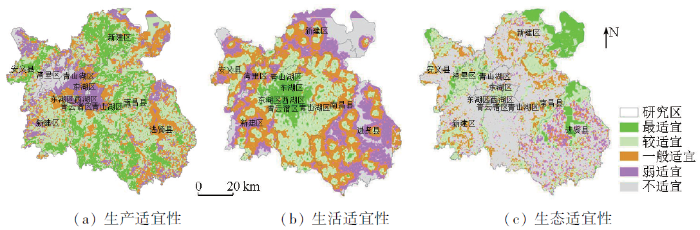
图2
南昌市生产、生活与生态适宜性的空间分布
Fig.2
Spatial distribution of production, life and ecological suitability in Nanchang
表3 “三生”适宜性评价结果表
Tab.3
| 适宜性等级 | 生产适宜性 | 生活适宜性 | 生态适宜性 | |||
|---|---|---|---|---|---|---|
| 面积/hm2 | 比例/% | 面积/hm2 | 比例/% | 面积/hm2 | 比例/% | |
| 最适宜 | 148 043.47 | 20.58 | 52 242.66 | 7.26 | 60 483.13 | 8.41 |
| 较适宜 | 261 413.48 | 36.33 | 201 816.26 | 28.05 | 163 820.13 | 22.77 |
| 一般适宜 | 169 848.58 | 23.61 | 213 672.35 | 29.70 | 104 812.65 | 14.57 |
| 弱适宜 | 105 498.56 | 14.66 | 167 532.29 | 23.28 | 53 983.64 | 7.50 |
| 不适宜 | 34 695.90 | 4.82 | 84 236.44 | 11.71 | 336 400.45 | 46.75 |
1)生产适宜性具有明显的“条带状”空间分布特征,总体呈现中北部、南部适宜强,中西部适宜性低的特征,这与南昌市农业发展区位较为一致。具体来看,南昌市土地利用生产最适宜区主要分布在南昌市中部,该区域坡度较低、离河流近,生产条件好; 土地利用生产较适宜区分布在最适宜区的周边,生产条件较最适宜区稍差,分布较为破碎; 一般适宜区主要分布在进贤县中部、新建区最北部,该区域普遍为坡度较高; 弱适宜区与不适宜区呈现“块状”结构,分布在南昌市主城区与湾里区,即生活中心与山脉。
2)生活适宜性表现出多个“中心-外围”的集聚状态,最终形成大组团、小组团及条状交错分布。最适宜区主要分布在主城区及各个县中心部分; 较适宜区则分布在最适宜区的四周,相对于最适宜的教育、医疗设施距离更远,但属于辐射范围内; 一般适宜区的共同点是邻近行政村的教育机构与医疗设施,故安义县、新建区、南昌县、进贤县有较多这样的区域存在; 弱适宜区与不适宜区主要分布在进贤县的中部、南部及新建区的最北部,尤其不适宜区在新建区北部呈现明显线状,这主要是根据《耕地保护法(草案)》(征求意见稿)非必要不占用耕地,将耕地划分为1分值,同时根据管控原则将鄱阳湖国家级自然保护区划分为1分值,这两者外围具有线状特征。
3)生态适宜区分布空间连通性差,这与近年来经济发展迅速、城市用地快速增加有关。生态最适宜区主要位于新建区北部、进贤县的北部及湾里区,这3个区域植被归一化指数高、林地多; 较适宜区主要分布在南昌市周边; 一般适宜区面积较少,主要分布在水域周边,这些区域生态适宜性较好; 弱适宜区与不适宜区面积过半,主要分布在南昌市主城区。
3.2 潜在土地冲突分布特征
图3
图3
南昌市潜在冲突识别结果
Fig.3
Identification results of potential land use conflict in Nanchang
表4 潜在土地利用冲突区结果统计
Tab.4
| 一级冲 突类型 | 面积/hm2 | 比例/% | 二级冲 突类型 | 面积/ hm2 | 比例/% |
|---|---|---|---|---|---|
| P | 498 054.77 | 69.22 | P1 | 263 220.44 | 36.58 |
| P2 | 94 367.48 | 13.12 | |||
| P3 | 140 466.85 | 19.52 | |||
| HC | 3 777.73 | 0.53 | HC1 | 3 481.87 | 0.48 |
| HC2 | 119.52 | 0.02 | |||
| HC3 | 172.48 | 0.02 | |||
| HC4 | 3.87 | 0.00 | |||
| SC | 135 348.99 | 18.81 | SC1 | 75 041.20 | 10.43 |
| SC2 | 37 758.39 | 5.25 | |||
| SC3 | 12 196.35 | 1.70 | |||
| SC4 | 10 353.05 | 1.44 | |||
| MC | 41 523.38 | 5.77 | MC1 | 22 268.29 | 3.09 |
| MC2 | 7 532.12 | 1.05 | |||
| MC3 | 4 256.37 | 0.59 | |||
| MC4 | 7 466.59 | 1.04 | |||
| LC | 40 795.12 | 5.67 | LC | 40 795.12 | 5.67 |
1)剧烈冲突区(HC)面积为3 777.73 hm2,占比0.53%,未来极有可能演变成实际冲突区域。在该区域,HC1面积最大,占剧烈冲突区总面积的92.17%,主要位于南昌县,原因是该地区的社会经济基础处于生产生活均适用时期,对生产生活活动具有很强的集聚效应。然而,随着经济社会发展加快,对生活用地的需求也会相应增加,这一地区将成为城市扩张和利用的关键,农业生产用地将在竞争中逐渐失去其经济优势。HC2及HC3面积均较小且相差不大。
2)强烈冲突区(SC)面积为135 348.99 hm2,占比18.81%,是所有冲突区占比最大的,虽然该区域短期内不太可能发生严重冲突,但风险仍然存在,是未来冲突缓解的重点区域。在强烈冲突区中SC1面积最大且分散于中心城区外的南昌县、安义县及新建区最南与最北部,这些地区属于平原且靠近集中生活区,不仅适宜生产,也具备生活优势,故形成了明显的生产生活中度冲突区。SC2面积次之,位于平原向山地的过渡地带,适宜生产,同时具有生态敏感性。
3)中度冲突区(MC)面积为41 523.38 hm2,占比5.77%,分布在SC区外围连接处,与SC类似,MC1面积最大。
4)微弱冲突区域(LC)占总的潜在冲突地区的5.67%,分散在进贤县东南部的钟陵乡及御前乡、新建区西南部山地丘陵区及安义县山区,其用地冲突较小,根据土地利用现状类型主导利用即可。
3.3 基于识别结果的分区识别及差异化调控措施
表5 南昌市分区调控表
Tab.5
| 分区调 控类型 | 分区依据 | 主导用 地类型 | 面积/hm2 | 占比/% | 调控措施 |
|---|---|---|---|---|---|
| 优先治理-城乡发展 区PM1 | 南昌大都市/安义绿色发展区/进贤综合发展区+剧烈冲突区/强烈冲突区 | 建设用地 | 33 267.99 | 4.62 | 优先治理,刚性与弹性的结合,一方面贯彻建设用地总量控制与永久基本农田保护,另一方面预留一定面积作为弹性用地,防止潜在土地利用冲突转化为现实 |
| 优先治理-粮食发展 区PM2 | 赣江下游粮食主产区/锦江流域粮食主产区/抚河流域粮食主产区/军山湖沿岸富硒农业区+剧烈冲突区/强烈冲突区 | 耕地、园地、其他农用地 | 82 352.32 | 11.45 | 优先治理,治理要点优先保护永久基本农田,HC3与SC3紧邻生活区的可划分为弹性城镇发展区 |
| 优先治理-生态保护 区PM3 | 鄱阳湖生态核心区/梅岭-峤岭/军山湖+剧烈冲突区/强烈冲突区 | 草地、林地、未利用地、水域 | 23 543.67 | 3.27 | 生态优先,HC1与HC2中连片性较好的划入耕地范围,严格管控建设用地扩张 |
| 重点治理-城乡发展 区KM1 | 南昌大都市/安义绿色发展区/进贤综合发展区+中度冲突区 | 建设用地 | 7 988.28 | 1.11 | 挖掘城市空间资源,防止优质耕地被建设用地占用,引导该区域发展设施农业和高价值经济作物来提升农业竞争力 |
| 重点治理-粮食发展 区KM2 | 赣江下游粮食主产区/锦江流域粮食主产区/抚河流域粮食主产区/军山湖沿岸富硒农业区+中度冲突区 | 耕地、园地、其他农用地 | 22 745.45 | 3.16 | 重点治理,治理要点优先保留生产适宜性,其他优化空间环境矛盾 |
| 重点治理-生态保护 区KM3 | 鄱阳湖生态核心区/梅岭-峤岭/军山湖+剧烈冲突区/强烈冲突区 | 草地、林地、未利用地、水域 | 10 586.07 | 1.47 | 生态优先,HC1与HC2中连片性较好的划入耕地范围,严格管控建设用地扩张 |
| 稳步推进-城乡发展 区SP1 | 南昌大都市/安义绿色发展区/进贤综合发展区+微弱冲突区/用地适宜区 | 建设用地 | 118 697.52 | 16.50 | 稳步持续推进城乡发展 |
| 稳步推进-粮食发展 区SP2 | 赣江下游粮食主产区/锦江流域粮食主产区/抚河流域粮食主产区/军山湖沿岸富硒农业区+微弱冲突区/用地适宜区 | 耕地、园地、其他农用地 | 265 407.20 | 36.89 | 稳步持续推进粮食种植 |
| 稳步推进-生态保护 区SP3 | 鄱阳湖生态核心区/梅岭-峤岭/军山湖+微弱冲突区/用地适宜区 | 草地、林地、未利用地、水域 | 154 911.50 | 21.53 | 可持续保护生态环境 |
图4
图4
南昌市土地利用冲突调控分区图
Fig.4
Types of land use conflict regulation in Nanchang City
4 讨论与结论
4.1 讨论
尽管本研究构建的城市生产、生活及生态适宜性评价模型、潜在土地利用冲突识别及强度诊断模型可以较为精准地揭示城市土地利用冲突的格局,但冲突发生的本质是争夺有限的土地资源的过程[27],这意味着冲突的缓解有赖于土地利用方式的转变,也要求多方利益主体的协调共治。探讨3大主体的利益均衡及土地利用适宜性角度下的土地利用冲突缓解策略是下一步的研究重点和方向。
4.2 结论
1)通过多目标适宜性评价模型方法评价南昌市“三生”适宜性,数量分析结果表明生产与生活一般及以上适宜区占比均超过65%,说明南昌市大部分土地同时具备生产生活条件,存在较大潜在土地利用冲突的可能性。南昌市生态、生产与生活适宜性的空间分布和结构组成各异,同一位置存在不同等级、不同类别的适宜区,说明研究区“三生”适宜性存在一定的交叉、聚集与重叠,潜在土地利用冲突发生概率较大。
2)2020年南昌市潜在土地利用冲突区占总面积的30.78%,剧烈冲突区、强烈冲突区、中度冲突区、微弱冲突区分别占冲突总量的1.72%,61.11%,18.75%和18.42%,强烈冲突区是潜在冲突区的主要部分,也是未来治理的核心区域。总体南昌市潜在土地利用冲突区的空间分布、表现状态及程度均有区别,这也决定了需要采用差别化治理措施缓解冲突矛盾。土地利用混乱对生态弱势区域的影响更加明显,土地利用冲突缓解十分有必要。
3)研究不仅考虑了土地适宜性,也兼顾了国土空间自身系统及社会经济发展需要,划分9大分区并提出了差别化调控建议。其中优先治理区是防止潜在土地利用冲突转化为现实的关键,重点治理区是进一步缓解土地利用冲突的重点,也是维持土地适宜性利用的关键地带。
参考文献
城镇化进程中土地利用冲突及其缓解机制研究——基于非合作博弈的视角
[J].
Research of the land use conflict and mitigation mechanism during the urbanization in China
[J].
Land use change and socio-environmental conflict in the Alt Empordà County (Catalonia,Spain)
[J].
Function-analysis and valuation as a tool to assess land use conflicts in planning for sustainable,multi-functional landscapes
[J].
Land use conflicts in central Sudan:Perception and local coping mechanisms
[J].
Land use evolution and management under recurrent conflict conditions:Umbundu agroforestry system in the Angolan Highlands
[J].
中国土地利用冲突研究进展
[J].
DOI:10.18306/dlkxjz.2020.02.011
[本文引用: 2]

中国正处于经济转型与社会发展的关键时期,土地利用面临着巨大的压力和挑战,土地利用结构失衡凸显,各类用地矛盾日趋激烈,由此引发的土地利用冲突问题日益受到重视,相关研究成果大量涌现却缺少系统的梳理与总结。论文运用文献资料法厘清国内土地利用冲突研究取得的成效,并通过文献总结和对比分析指出现有研究存在的不足,进而为中国土地利用冲突研究提出了新的方向。首先,在对已有文献中土地利用冲突相关概念辨析的基础上,指出土地利用冲突是土地资源利用过程中,利益相关者围绕土地利用方式与结构所产生的人地之间的空间竞争与权益冲突的现象。其次,从土地利用冲突的理论基础、土地利用冲突的利益相关者、土地利用冲突的识别与强度诊断、土地利用冲突的表现形式及分类、土地利用冲突的演变及其驱动机制、土地利用冲突的和解等6个方面对国内相关研究进行归纳和总结。最后,通过对国内外研究成果的梳理和比较提出了未来中国土地利用冲突研究的主要方向:① 经济社会转型背景下土地利用冲突理论体系的补充与完善;② 全球化背景下土地利用冲突研究的内容拓展与范式革新;③ 乡村振兴战略背景下城乡土地利用冲突的空间正义与效率;④ 参与式GIS技术支持下土地利用冲突的定量与定位治理;⑤ 国土空间规划体系整合下土地利用冲突的协调与权衡;⑥ 多学科融合视角下土地利用冲突的集成分析与成果应用。
Research progress and prospect of land-use conflicts in China
[J].
DOI:10.18306/dlkxjz.2020.02.011
[本文引用: 2]
China is in a critical period of economic transformation and social development, which brings great pressure and challenges to land use. Therefore, imbalanced land-use structure and conflicting land utilization become more common, which result in more attention to land-use conflicts and thus increasingly more related studies has appeared, but there is a lack of systematic review and compilation of existing research. This study examined the research related to land-use conflicts in China through literature analysis and comparative analysis, and identified the research trends. First, this article points out that land-use conflict refers to the phenomenon of spatial competition and conflicting interests between people and land caused by the way and structure of land use by stakeholders in the process of land use, which was defined by the comparison and identification among relevant concepts related to land-use conflicts in the existing literature. Second, the Chinese land-use conflict research results were summarized and elaborated from six aspects, including the theoretical basis of land-use conflicts, the stakeholders in land-use conflicts, the identification and intensity diagnosis of land-use conflicts, the forms and classification of land-use conflicts, the evolution of land-use conflicts and its driving mechanisms, and the reconciliation program of land-use conflicts. Finally, through reviewing and comparing Chinese and international research results, this article puts forward the future direction of China's land-use conflict research: 1) Complement and improvement of land-use conflicts theoretical system under the background of economic and social transformation. 2) Content expansion and paradigm innovation of land-use conflict research considering the global scale. 3) Spatial justice and efficiency of land-use conflict resolution in the context of rural revitalization strategy. 4) Quantitative and precision management of land-use conflicts with the support of participatory GIS. 5) Coordination and trade-off of land-use conflict resolution under the integration of national spatial planning systems. 6) Comprehensive analysis and results application of land-use conflicts from the perspective of multidisciplinary integration.
基于“风险—效应”的土地利用空间冲突识别与测度
[J].
Recognizing and measuring spatial conflict of land use via “risk-effect”
[J].
基于“三生”适宜性的县域土地利用冲突识别与分析
[J].
DOI:10.31497/zrzyxb.20210512
[本文引用: 2]
精准识别潜在土地利用冲突有利于预警权衡和协调冲突用地,有利于科学进行国土空间规划。以“三调”修正数据为基础,基于生产、生活、生态视角,构建高植被覆盖率县域生产、生活、生态即“三生”适宜性评价模型与土地利用冲突识别矩阵,并选取横峰县进行实证分析。结果表明:(1)横峰县“三生”适宜性用地的空间分布与面积构成差异显著,且存在明显的空间叠加特征,暗示着研究区土地利用存在冲突;(2)从潜在冲突识别的结果来看,土地利用适宜区、冲突激烈区、冲突中度区、冲突一般区及冲突微弱区面积占比分别为64.02%、9.66%、17.19%、1.66%、7.48%;(3)各个冲突类型区空间分布、表现形式的差异性决定了冲突和解的对策也需因地制宜。研究结果可为相关及类似县域的国土空间规划提供理论参考。
Recognition and analysis of land use conflicts at county level based on “production-living-ecological” suitability
[J].
乌鲁木齐市土地利用变化及其空间冲突测度
[J].
Measurement of land use change and spatial conflict in Urumqi
[J].
基于行动者网络的土地利用冲突及其治理机制研究——以广州市海珠区果林保护区为例
[J].
Land use conflicts and their governance mechanics on actors network theory: A case of fruit tree protection zone of Haizhu District,Guangzhou City
[J].
土地利用冲突的时空格局刻画与多情景模拟研究——以长江三角洲城市群为例
[J].
DOI:10.11821/dlyj020210375
[本文引用: 3]
科学刻画与模拟土地利用冲突的时空演化格局是精准认知区域土地利用结构进而寻求人地关系协调的基础。采用景观格局指数构建土地利用冲突模型,借助GIS等手段分析长江三角洲城市群1980—2020年间土地利用冲突的时空演化特征,并结合斑块生成土地利用变化模拟模型和多目标规划法多情景模拟2035年的土地利用冲突格局。结果表明:①长江三角洲城市群土地利用冲突受地形等因素影响呈现“北高南低”的分布格局,且在高速城镇化和城市无序蔓延等因素作用下,人地关系趋于不协调发展,土地利用冲突程度逐年加剧。②受人口迁徙和城镇化发展阶段的影响,土地利用冲突的热点区域由乡村空间转移至了城市空间。③在土地利用过程中,耕地是各利益主体争夺的核心区域,也是权衡土地利用冲突的“关键地带”。④可持续发展情景兼顾了经济发展与生态保护两方面的用地需求,是缓和土地利用冲突的一种合理选择。
Spatio-temporal pattern and multi-scenario simulation of land use conflict:A case study of the Yangtze River Delta urban agglomeration
[J].
新疆乌鲁木齐市“三生”用地的空间冲突研究
[J].
Spatial conflicts of productive-living-ecological land in Urumqi City of Xinjiang Wei Autonomous Region
[J].
基于F-H方法的漓江流域土地利用冲突识别
[J].
Land use conflict based on F-H method in the Lijiang River basin,China
[J].
基于土地利用冲突识别的国家公园社区调控研究——以钱江源国家公园为例
[J].
Community regulation in national park based on land use conflict identification:A case study on Qianjiangyuan National Park
[J].
基于演化博弈的土地利用冲突缓解机制研究——以沈抚新区为例
[J].
Mitigation mechanism of land use conflicts based on evolutionary game:A case study of Shenfu New Area
[J].
基于PSR模型的农区土地利用冲突强度的诊断
[J].
Diagnosis based on the PSR model of rural land-use conflicts intensity
[J].
DOI:10.11820/dlkxjz.2012.11.017
[本文引用: 1]
With the acceleration of industrialization and urbanization, rural land-use conflict has become more frequent. It is of great significance to rural development to analyze the forms of land-use conflict and assess its intensity in different rural areas. This paper presents the studies in the distinctive rural areas of Yanling County from 1990 to 2010. Using correlation analysis and principal component analysis, among the 32 driving factors in the categories of population, social economy and agriculture intensification that cause the changes of arable land-use in Yanling County, 6 major factors are identified. Based on the studies of structural changes of land-use as well as municipal policies and regulations and their effects on the social and ecological environment, an indicator system is established, and the intensity of the land-use conflict is evaluated by using Pressure-State-Response Index of Land-use (ILU). The results show that the pressure on land-use is increasing on yearly basis, the state is deteriorating, and the response is gradually strengthened. Overall, the intensity of land-use conflict in Yanling County has increased from 1990 to 2010. The three major causes for the intensified land-use conflict are as follows: (1) economic development and changes of economic structures. Increase of farmers’income brings changes to way of life and means of work, which in turn affects the composition of workforce and the choice of occupation, and then changes land-use and causes dramatic changes to the industrial structures of Yanling County, leading to intensified conflicts between arable land and construction land, and between arable land and forest land. (2) Changes of agricultural activities. The industrialization of flower and livestock business provides more economic benefits to rural households, constantly drives changes and adjustments in the structure of agricultural activities, and causes land-use conflicts. However, obviously the small business of family-owned contract service conflicts the large-scale operation required by modern agriculture. (3) Influences of the development in science and technology and the government policies, etc. Government policies serve to attenuate the land-use conflicts to some extent. From the conflict management perspective, we propose that government can regulate land-use by utilizing the self-adjustment mechanism of the market and reinforcing the policies on planning. Land-use conflict can be prevented or minimized by improving the effectiveness of land-use through multipurpose planning and balancing, and by standardizing the better ways to use the land.
Using multi-criteria analysis for the identification of spatial land-use conflicts in the Bucharest Metropolitan Area
[J].
干旱区河谷绿洲土地利用冲突格局分析
[J].
An analysis of the pattern of land-use conflicts in valley oases in arid areas
[J].
基于多目标适宜性和竞争力的区域潜在土地利用冲突的诊断研究
[J].
Research on regional potential land use conflict diagnosis based on multi-objective suitability and competitiveness
[J].
Smart land-use analysis:The LUCIS model land-use conflict identification strategy
[M].
基于“三生”适宜性的旅游度假区潜在土地利用冲突识别与治理
[J].
Identification and governance of potential land use conflicts in tourism resort based on ecological-production-living suitability
[J].
基于ArcGIS空间图形插值法的致密气资源评价——以俄罗斯蒂曼—伯朝拉盆地为例
[J].
Tight gas resourc evaluation based on ArcGIS spatial graph interpolation method:A case study of Timan-Pechora Basin in Russia
[J].
城乡规划编制中的“三生空间”划定思考
[J].
Reflections on delimiting the three basic spaces in the compilation of urban and rural plans
[J].
南昌市土地利用的空间冲突风险评估及分区优化研究——基于“三生空间”视角
[J].
DOI:10.3969/j.issn.1004-9479.2021.03.2019676
[本文引用: 1]
以土地利用的导向功能为基础,将南昌市1995、2005和2015三期20种土地利用类型划分为生态生产空间、生产生态空间、生态空间和生活生产空间。利用空间复杂性指数、空间脆弱性指数和空间稳定性指数3个因子构建冲突模型,借鉴倒“U”型模型,将空间冲突分为4类:稳定可控、基本可控、基本失控和严重失控,在冲突级别的基础上利用优化产业结构、生态系统修复等措施,建立10个亚功能区,优化土地资源,缓解空间冲突,实现可持续发展。研究结果表明:①1995—2015年中南昌市三生空间格局以生产生态空间为主,其次是生态空间、生态生产空间以及生活生产空间,生活生产空间所占比例在上升,其余均在减少,呈现“一升三降”特点;②1995—2015年南昌市三生空间空间冲突愈演愈烈,严重失控单元持续增长,但2005—2015年的增长速度较1995—2005年稍慢,南昌市三生空间冲突失控态势严峻;③不同空间类型冲突存在较大差异,均以可控级别为主,其中失控级别占比由大到小:生活生产空间?生产生态空间?生态生产空间?生态空间;④利用10个亚功能区优化南昌市70%以上的区域,其中以城镇用地等为主的两个亚功能区,70%以上属于允许建设区,以滩地、湖泊、林地等为主亚功能区65%以上属于禁止建设区,符合土地利用总体规划。
Research on spatial conflict calculation and zoning optimization of land use in Nanchang City from the perspective of “three living spaces”
[J].
南昌市土地利用的空间冲突测算与分析
[J].
Calculation and analysis of spatial conflicts in land use of Nanchang City
[J].
