

0 引言
河西走廊位于内陆干旱地区,水资源短缺,地下水作为地表水的补充,是河西地区农业灌溉、工矿和城市的重要水源,近年来,地下水利用比重不断上升导致地下水位显著下降,引起了局部地区地面沉降,直接影响了当地水资源管理、农业生产、生态保护和城市建设的可持续发展。因此,揭示地下水变化与地面沉降滞后性对该地区发展具有广泛而深远的影响[1]。
当前监测地下水变化主要是利用地下水井观测[2],该方法观测范围小,难以满足大尺度地下水变化[3],而由美国航天局与德国航天局联合研制的GRACE卫星因其不受地形、气候等因素影响为反演地下水动态变化提供了新的途径[4]。早期用于地表形变监测方法包括水准测量、全球定位系统等,然而这些方法获取数据所需成本高、覆盖范围小[5],耗时费力。随着合成孔径雷达干涉测量技术(interferometry synthetic aperture Radar,InSAR)发展,差分合成孔径雷达干涉测量(differential interferometric synthetic aperture Radar,D-InSAR)技术得到应用,与传统测量相比具有精度高、效率快、覆盖范围广等优点[6],已广泛运用于形变监测、滑坡灾害预测及地震形变[5],但D-InSAR技术易受时空失相干与大气延迟等因素制约[7]。为克服这些因素影响,研究人员提出了永久散射体InSAR技术(persistent scatters -InSAR,PS-InSAR)和小基线集InSAR技术(small baseline subset -InSAR,SBAS-InSAR)[7]。由此,Guo等[8]利用GRACE数据和SBAS-InSAR监测技术得到北京地区地下水变化和地表沉降数据以及两者之间的相关性; Vasco等[9]利用GRACE和合成孔径雷达(synthetic aperture Radar,SAR)数据得到图莱里盆地地表沉降与地下水储量变化的关系; Massoud等[10]通过GRACE数据反演得到黎巴嫩平原地下水变化趋势并结合SAR数据和监测井数据证实了研究结果。基于上述研究可知,将GRACE与InSAR数据结合能够更好地揭示地下水变化对地表沉降的影响[11],但针对河西地区相关研究较少,未能有效、明确地阐述当地地面沉降对地表水变化的滞后响应。
本文利用GRACE和GLDAS数据解算得到研究区地下水年内、年际变化数据(缺失月份数据采用奇异谱插值法将其补齐),并用监测井实测数据验证反演地下水变化数据的可靠性。采用SBAS-InSAR技术得到地表形变数据,用PS-InSAR技术对形变结果进行对比验证,在此基础上运用快速傅里叶变换(fast Fourier transform,FFT)将地下水变化和地表沉降数据进行解算得到地面沉降较地下水变化滞后天数,通过时滞互相关分析两者的相关性,为今后河西地区在水资源管理、土地利用规划和农业发展方面提供了科学依据。
1 研究区概况及数据源
1.1 研究区概况
1.2 数据源
SAR数据采用Sentinel-1A单式复数影像及同期卫星精密轨道数据[16]; 数字高程模型(digital elevation model,DEM)为GDEMV2 30m空间分辨率数据; GRACE数据采用德克萨斯大学空间研究中心(Center for Space Research at the University of Teaxs,CSR)提供的Level-2 RL06版本的GSM数据模型,时间范围为2003年3月—2017年6月,阶次为96; GLDAS数据为GLDAS_NOAH025_M_2.1版本的GLDAS模型数据[17],时间尺度为1个月,空间分辨率为0.25°
2 研究方法
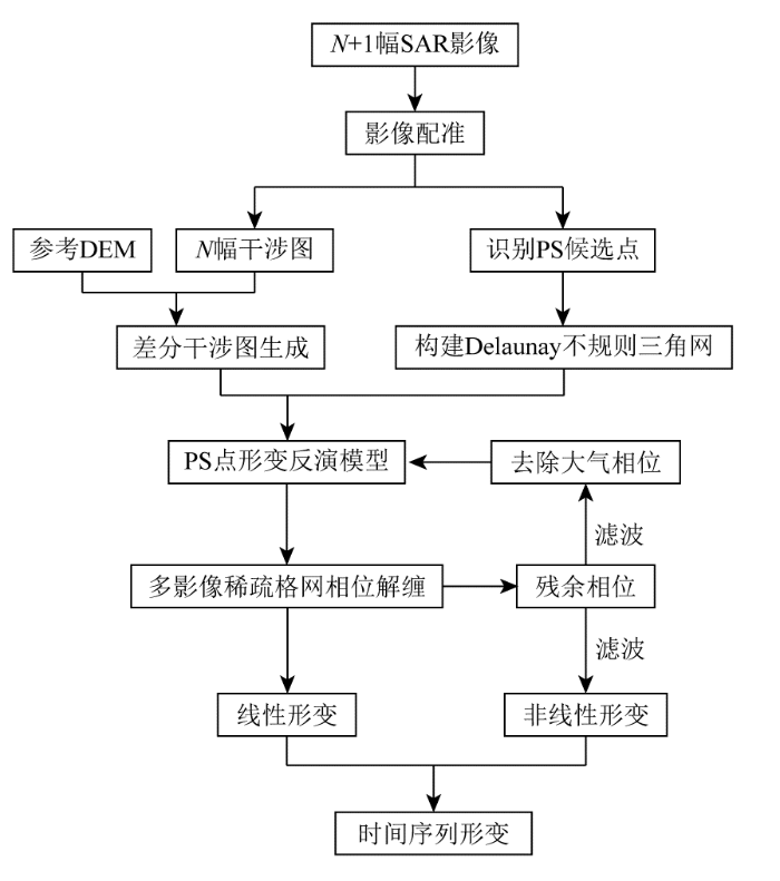
2.1 PS-InSAR技术原理
图1
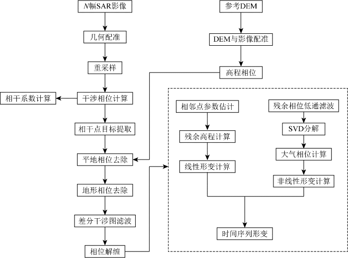
2.2 SBAS-InSAR技术原理
图2
2.3 GRACE时变重力场反演地下水储量
本文将GRACE数据中的低阶项C20用卫星激光测距所测精度更高的C20项替换,加入GRACE数据计算的地心改正项修正一阶系数[21],然后采用高斯滤波与去相关滤波方法,把获得的研究区域真实质量以等效水高表示为:
由GRACE数据得到的陆地水
式中: ΔGW为研究区地下水变化量,ΔTWS为研究区水储量变化量; ΔSM为土壤水变化量; ΔSWE为雪水当量变化量。
2.4 地面沉降与地下水变化滞后性
地下水变化与地面沉降是相关过程,通过FFT处理地下水变化与地面沉降数据,可得到二者在不同频率下的幅度和相位信息,若2个信号存在滞后关系,则它们在某些频率下的相位信息会发生变化,通过分析相位变化,可得到二者滞后时间。本文运用FFT将二者数据的时域信号转化为频域信号,然后共轭相乘,再进行FFT逆变换得到交叉相关性延迟数组,找到数组中最大值所对应的延迟位置,即为滞后时间。
设地下水变化与地面沉降的时间序列
式中:
3 结果与分析
3.1 地面沉降
3.1.1 形变监测结果
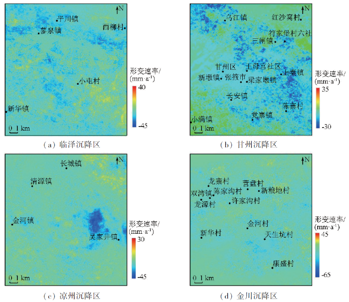
利用SBAS-InSAR技术对研究区Sentinel-1A数据进行地表形变特征信息提取,获得沉降区地表形变速率,如图3所示。由图可知,临泽沉降区地表形变速率在-45~40 mm/a之间,在平川镇、新华镇沉降达到了-36~-20 mm/a; 甘州沉降区地表形变速率在-30~35 mm/a之间,在上秦镇、长安镇地表形变速率达到了-25~-10 mm/a; 凉州沉降区地表形变速率在-45~30 mm/a之间, 在吴家井镇沉降达到了-30~-15 mm/a; 金川沉降区地表形变速率在-65~45 mm/a之间,在康盛村沉降达到了-45~-15 mm/a。实验结果与已有研究成果[13]一致。从图3可知,研究区局部区域有抬升现象,依据现有的文献资料,原因有: ①随着时间推移,局部地区地下水位会通过灌溉水、降雨等方式得到恢复,导致局部区域出现隆起现象[16]; ②人为土地利用也会使地表产生不同程度的抬升与沉降[23]; ③季节性或年际地下水位波动可能会导致局部区域抬升[24]。
图3
3.1.2 PS-InSAR结果差异性对比
由于缺少同期地面观测数据,本文对各个沉降区利用PS-InSAR技术得到的PS点和SBAS-InSAR技术得到的散射体位移场点(scatterer displacement field point, SDFP)进行统计分析,结果如图4所示。
图4-1
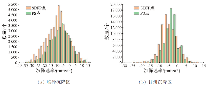
图4-2
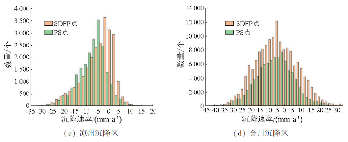
为进一步探究2种监测结果之间的差异,利用ArcGIS软件在沉降区域选取同名点(具有相同地理坐标)建立回归方程,分析2种结果之间的相关性,如图5所示。由图可知,PS点和SDFP点形变速率具有较高相关性,4个沉降区R2分别为0.837 23,0.781 44,0.813 82,0.796 93,说明2种方法得到的年平均沉降速率具有一致性,也证明了数据的可靠性。
图5
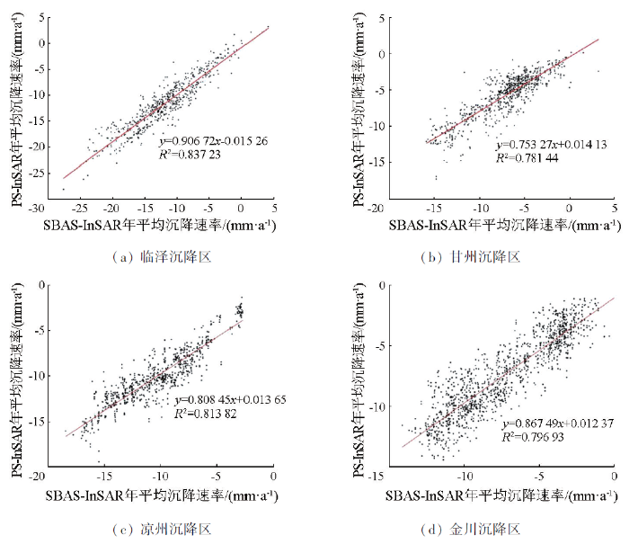
图5
PS与SBAS年平均沉降速率相关性
Fig.5
Correlation between PS and SBAS annual average subsidence rate
3.2 地下水储量变化
3.2.1 地下水储量变化速率空间分布
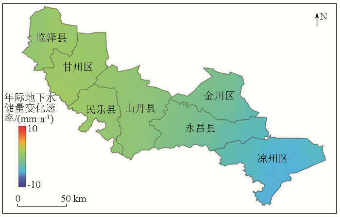
用反演的地下水变化数据可得到2010年1月—2017年6月年际地下水变化速率,如图6所示,临泽县、甘州区地下水变化速率为0~4 mm/a,水储量呈现缓慢增长趋势;金川区、凉州区地下水变化速率为-10~0 mm/a,水储量变化较临泽县、甘州区亏损严重。
图6
3.2.2 地下水变化验证
为验证反演得到的地下水变化数据,本文采用研究区监测井实测数据与其进行对比,由于与GRACE结果相当的等效水位只能通过实测地下水与给水度之积得到,因此只对二者趋势进行定性分析,如图7所示。
图7
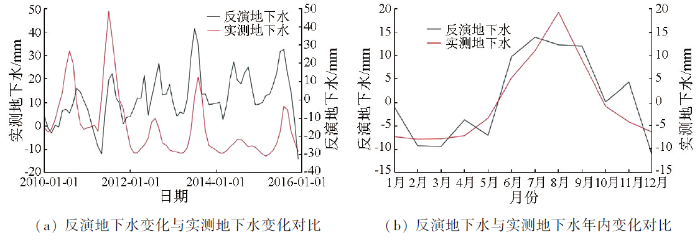
图7
反演地下水与实测地下水变化
Fig.7
Changes in inverted groundwater and measured groundwater changes
3.3 地面沉降与地下水变化滞后性分析
3.3.1 滞后时间计算
采用FFT将不同沉降区地下水变化与地面沉降数据进行解算,结果如表1所示。
表1 地面沉降与地下水变化滞后时间
Tab.1
| 地区 | 地表沉降速率/(mm·a-1) | 滞后时间/d |
|---|---|---|
| 临泽沉降区 | -36 ~-20 | 74~86 |
| 甘州沉降区 | -25 ~-10 | 61~80 |
| 凉州沉降区 | -30 ~-15 | 80~99 |
| 金川沉降区 | -45 ~-15 | 74~99 |
3.3.2 时滞互相关分析
表2 地面沉降与地下水变化相关系数
Tab.2
| 地区 | 时滞互相关系数 | 所占比例/% |
|---|---|---|
| 临泽沉降区 | 0.541~0.593 | 61.90 |
| 甘州沉降区 | 0.589~0.689 | 69.23 |
| 凉州沉降区 | 0.600~0.750 | 78.42 |
| 金川沉降区 | 0.543~0.630 | 68.30 |
3.3.3 地面沉降与地下水变化关系
通过对每个沉降区若干点进行多项式拟合,得到各个沉降区地下水变化与地面沉降时间变化曲线,如图8所示。
图8
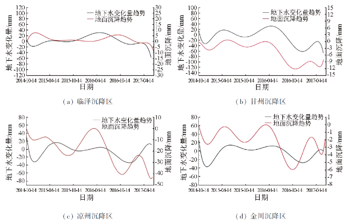
图8
地表沉降与地下水变化关系
Fig.8
Relationship between land subsidence and groundwater change
引起地表沉降的因素很多,且不同地区所属地理环境与地质土层结构不一样,为了进一步分析滞后时间与相关系数在空间上的表现,采用反距离平均插值法得到滞后时间及相关系数的空间变化,如图9所示。
图9
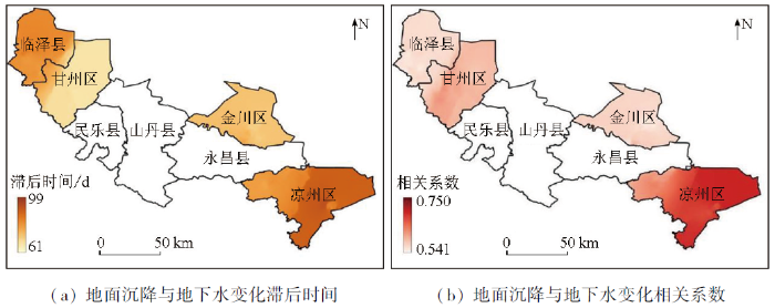
图9
滞后时间及相关系数空间变化
Fig.9
Spatial distribution of lag time and spatial variation of correlation coefficient
4 结论
利用SBAS-InSAR技术和GRACE时变重力场反演数据得到了研究区地下水变化与地面沉降数据,并采用PS-InSAR技术和实测地下水数据验证了实验数据的可靠性。运用FFT和时滞互相关分析解算了地面沉降较地下水变化滞后时间及相关系数,主要结论如下:
1)2010年1月—2017年6月,凉州、金川地区地下水变化速率在-10~0 mm/a,水储量呈现亏损状态; 临泽、甘州地区地下水变化速率在0~4 mm/a。通过与实测地下水数据进行年内相关性分析(R为0.867),为极强相关,验证了地下水数据的可靠性。
2)利用SBAS-InSAR技术,得到了沉降区地表形变数据,采用PS-InSAR技术对形变数据进行对比验证,得出2种方法得到的年平均沉降速率具有一致性,证明了数据的可靠性。
3)采用FFT计算地面沉降较地下水变化滞后时间,得到临泽、甘州、凉州、金川沉降区地面沉降较地下水变化滞后时间分别为74~86 d,61~80 d,80~99 d,74~99 d,通过时滞互相关计算,得到相关系数区间分别为0.541~0.593,0.589~0.689,0.600~0.750,0.543~0.630。
4)通过对地面沉降较地下水变化滞后时间及二者相关系数空间分析可知,当地下水变化时,地表会发生相应的变化,二者相关性与滞后时间变化规律具有一致性。
本文通过FFT和时滞互相关分析得出了河西地区地下水变化滞后时间及相关系数,为河西地区水资源管理、土地利用规划和农业发展等提供科学依据,但本研究只是单一分析了地下水变化与地面沉降滞后性,对研究区部分区域抬升现象和不同沉降等级下二者滞后性问题触及较少,下一步需结合水准、水位和降雨等数据进一步分析滞后性规律和抬升区域驱动机制。
参考文献
新水情下利用InSAR-GRACE卫星的新兴风险预警与城市地下空间安全展望
[J].
Emerging risks and the prospect of urban underground space security based on InSAR-GRACE satellite under the new hydrological background
[J].
Assessing groundwater depletion and dynamics using GRACE and InSAR: Potential and limitations
[J].
DOI:10.1111/gwat.12453
PMID:27576068
[本文引用: 1]

In the last decade, remote sensing of the temporal variation of ground level and gravity has improved our understanding of groundwater dynamics and storage. Mass changes are measured by GRACE (Gravity Recovery and Climate Experiment) satellites, whereas ground deformation is measured by processing synthetic aperture radar satellites data using the InSAR (Interferometry of Synthetic Aperture Radar) techniques. Both methods are complementary and offer different sensitivities to aquifer system processes. GRACE is sensitive to mass changes over large spatial scales (more than 100,000 km ). As such, it fails in providing groundwater storage change estimates at local or regional scales relevant to most aquifer systems, and at which most groundwater management schemes are applied. However, InSAR measures ground displacement due to aquifer response to fluid-pressure changes. InSAR applications to groundwater depletion assessments are limited to aquifer systems susceptible to measurable deformation. Furthermore, the inversion of InSAR-derived displacement maps into volume of depleted groundwater storage (both reversible and largely irreversible) is confounded by vertical and horizontal variability of sediment compressibility. During the last decade, both techniques have shown increasing interest in the scientific community to complement available in situ observations where they are insufficient. In this review, we present the theoretical and conceptual bases of each method, and present idealized scenarios to highlight the potential benefits and challenges of combining these techniques to remotely assess groundwater storage changes and other aspects of the dynamics of aquifer systems.© 2016, National Ground Water Association.
Quantitative mapping of groundwater depletion at the water management scale using a combined GRACE/InSAR approach
[J].
Satellite-based estimates of groundwater depletion in India
[J].
基于时序InSAR的新疆阿希矿区地表形变监测与分析
[J].
Time-series InSAR-based monitoring and analysis of surface deformation in the Axi mining area,Xinjiang
[J].
黄河三角洲地面沉降现状及影响因素分析
[J].
Analysis of land subsidence status and influencing factors in Yellow River Delta
[J].
甘肃金川矿区地表三维形变InSAR监测
[J].
InSAR monitoring of 3D surface deformation in Jinchuan mining area,Gansu Province
[J].
Surface subsidence analysis by multi-temporal InSAR and GRACE: A case study in Beijing
[J].
Using Sentinel-1 and GRACE satellite data to monitor the hydrological variations within the Tulare Basin,California
[J].
Groundwater depletion signals in the Beqaa Plain,Lebanon:Evidence from GRACE and Sentinel-1 data
[J].
利用GRACE与Sentinel-1反演地下水变化与地表沉降研究
[J].
Study on inversion of ground-water change and surface subsidence using GRACE and Sentinel-1
[J].
河西走廊西部沙尘暴时空差异及其动力分析
[J].
Temporal and spatial differences and dynamic analysis of sandstorms in the west of Hexi Corridor
[J].
甘肃省地下水超采区地面沉降控制区判定方法和结果探讨
[J].在调查中,未发现地面沉降现象的情况下,结合地下水超采区多年的地下水位动态监测数据,根据含水层厚度、岩性和水位降幅等资料,采用水文地质条件比拟法划定甘肃省地下水超采区地面沉降控制区。对地下水超采区地面沉降控制区进行了分级,分级结果均为三级,并对地面沉降控制区进行了命名,可初步作为甘肃省地面沉降控制区范围,以便为制定地面沉降控制区地下水压采方案提供依据。首次提出了在没有地面沉降监测资料的情况下进行地面沉降控制区范围划定的方法。
Determination method and discussion of ground subsidence control area of groundwater overmining area in Gansu Province
[J].
Monitoring and analysis of surface deformation in mining area based on InSAR and GRACE
[J].
Improving the resolution of GRACE/InSAR groundwater storage estimations using a new subsidence feature weighted combination scheme
[J].
Monitoring of ground movement and groundwater changes in London using InSAR and GRACE
[J].
Groundwater vo-lume loss in Mexico City constrained by InSAR and GRACE observations and mechanical models
[J].
Monitoring groundwater change in California’s central valley using Sentinel-1 and GRACE observations
[J].
Nonlinear subsidence rate estimation using permanent scatterers in differential SAR interferometry
[J].
A new algorithm for surface deformation monitoring based on small baseline differential SAR interferograms
[J].
利用GRACE数据研究柴达木盆地区域水储量时空变化及干旱特征
[J].
Application of GRACE data in analysis on temporal and spatial changes of water reserves and drought characteristics of Qaidam Basin
[J].
气候因子与植被的时滞相关分析——以广西为例
[J].
Analysis on the time-lag correlation between vegetation and climatic factors:Take Guangxi as an example
[J].
PS-InSAR based monitoring of land subsidence by groundwater extraction for Lahore Metropolitan City,Pakistan
[J].
Mapping groundwater level and aquifer storage variations from InSAR measurements in the Madrid aquifer,Central Spain
[J].
PS-InSAR和SBAS-InSAR技术对昆明主城区地面沉降监测的对比分析
[J].
Analysis and comparison of PS-InSAR and SBAS-InSAR for ground subsidence monitoring in the main city of Kunming
[J].
