

0 引言
山西作为煤炭大省,人均水资源量为381 m3,仅为全国人均水平的17%,更是远低于人均500 m3的国际极度缺水标准[1]。自20世纪70年代以来,太原市工农业发展迅速,为满足能源基地建设以及农业灌溉需求,长期过度依赖地下水的开采。截至2010年,太原市承压水年开采量为69 457.9×10⁴ m3,潜水年开采量为1 218.7×10⁴ m3[2]。由于地下水的过度超采,地下水严重亏损,地下水位持续降低,引发了大范围区域性地面沉降。监测资料显示,1956—2003年,太原地面沉降涉及面积达到548 km2,在空间上形成了吴家堡、万柏林、下元和西张4个沉降漏斗中心,中心累计沉降量分别达到2 815 mm,951 mm,1 414 mm和697 mm[3]。2001年以后,随着太原南部小店经济技术开发区的发展,吴家堡沉降漏斗逐渐向南扩展,在小店区附近形成了新的沉降漏斗中心,其最大年均沉降速率达到100 mm/a[4]。
地面沉降是由于自然或人为因素导致地下松散岩土体固结压缩而引起地面标高降低的一种缓慢性地质灾害,其影响范围广、持续时间长等特点始终威胁着城市安全和经济社会可持续发展[5]。近年来,太原市大力实施严格的地下水资源管理制度,在严格控制地下水开采的同时,大力发展节水型产业,提高农业灌溉用水效率。另外,“引黄入晋”引水工程的实施,使太原市的用水结构由地下水开采为主转向从黄河调入的地表水为主。这些措施的实施极大地缓解了太原市水资源短缺问题,优化了用水结构,地下水位逐步回升。在地下水位持续抬升的过程中,各土层变形量及变形特征发生明显变化,地面沉降减缓,甚至出现地表回弹现象。因此,如何科学地评估地下水位回升对地面沉降的影响对于太原市进一步优化地面沉降防控措施和跨流域调水背景下的地下水资源管理具有重要意义。
星载干涉合成孔径雷达(interferometric synthetic aperture Radar, InSAR)可以全天时、全天候、大范围获取地面沉降信息,精度达到毫米至厘米级[6-
为此,本文基于覆盖太原市的2003—2010年ENVISAT ASAR数据和2017—2021年Sentinel-1的合成孔径雷达(synthetic aperture radar,SAR)数据,侧重于研究太原市在地下水位回升条件下地面沉降的时空变化。利用PS-InSAR时序分析处理技术,获得2个时间段太原市地面沉降速率以及沉降中心时间序列,对比分析跨越2个时间段地面沉降的时空变化,借以评估地下水位回升对地面沉降的影响效应。本文研究成果可以为太原市的地下水资源管理和地面沉降治理提供一定的参考价值。
1 研究区概况及数据源
1.1 研究区概况
图1
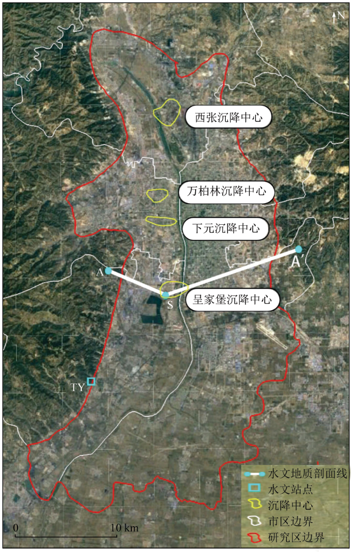
图2
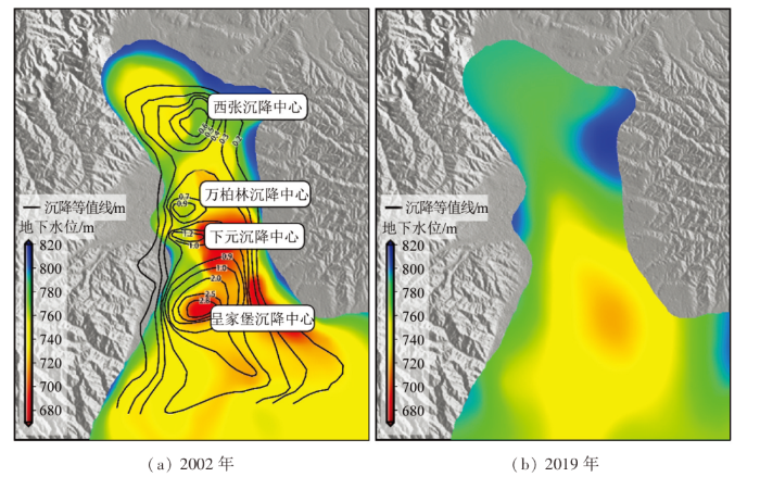
图3
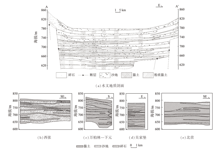
图3
太原市水文地质剖面及沉降中心剖面图
Fig.3
Hydrogeological profile and subsidence center profile in Taiyuan City
1.2 研究数据源
1.2.1 SAR数据
本文选取2003—2010年共39期ENVISAT ASAR数据和2017—2021年共113期Sentinel-1数据,用以获取2个时段太原市的地面沉降分布信息。通过对比2个时段的地面沉降数据从而研究太原市近20 a来地面沉降的时空演变格局。同时,本文从山西省测绘局获得了太原市 2个GNSS 站点坐标时间序列数据,用以验证InSAR 形变结果。
1.2.2 地下水数据
本文从山西省水利厅官网(
2 研究方法
本文基于PS-InSAR方法对2003—2010年39期ENVISAT影像和2017—2021年113期Sentinel-1影像进行处理,获取太原市地面沉降速率及其时间序列变化。
式中:
根据StaMPS算法文献[21],
式中:
基于筛选后的PS点进行三维相位解缠处理,最后利用最小二乘反演获取每个PS点对应的平均形变速率和时序形变。
3 结果和讨论
3.1 不同时段太原市地面沉降速率比较
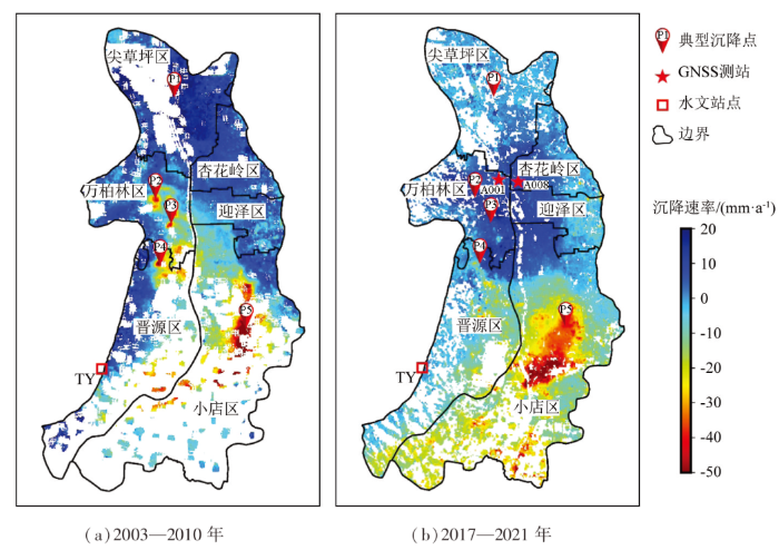
图4展示了利用PS-InSAR方法得到的太原市2个时段的地表形变速率,图中蓝色部分代表抬升,红色部分代表沉降。同时,在图中标注出5个典型沉降点位置(P1—P5)、2个GNSS测站位置(A001和A008)以及1个水文站点位置(TY)。从图4(a)中看出,太原市2003—2010年地面沉降集中在太原中部的主城区以及南部的小店区。主城区出现了几个局部的地面沉降漏斗,对应为万柏林、下元和吴家堡,这与前人的研究结果一致[3]。城区沉降最大的地区位于吴家堡,最大沉降速率达到56 mm/a,小店区沉降漏斗面积最大,最大沉降速率达到78 mm/a。在北部尖草坪区的西张,地面出现抬升,这表明西张沉降区(1956—2000年为沉降状态)率先出现了反弹。这与太原市率先在西张地区实施“关井压采”、该地区率先出现地下水位抬升一致。
图4
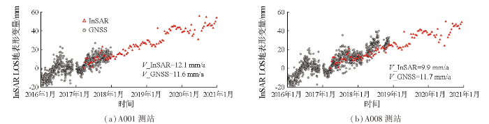
PS-InSAR结果与图4中2个GNSS测站的地表形变数据对比见图5。因GNSS数据只与本文的Sentinel-1数据在时间上具有重叠,所以本文只能比较这两者的形变,且图5中GNSS三维形变已转换到雷达视线方向(line-of-sight, LOS)。拟合计算得到A001测站PS-InSAR和GNSS分别测得的地面形变速率V_InSAR为12.1 mm/a,V_GNSS为11.6 mm/a,A008测站V_InSAR为9.9 mm/a,V_GNSS为11.7 mm/a。发现二者的形变时间序列较为吻合,同时这也体现出地面处于抬升状态,这也验证了图4(b)中地面抬升的结果。二者累计形变量RMSE约为5 mm,速率RMSE约为1.3 mm/a,验证了本文PS-InSAR形变提取结果的可靠性。
图5
3.2 太原市沉降中心形变时间序列比较
图6
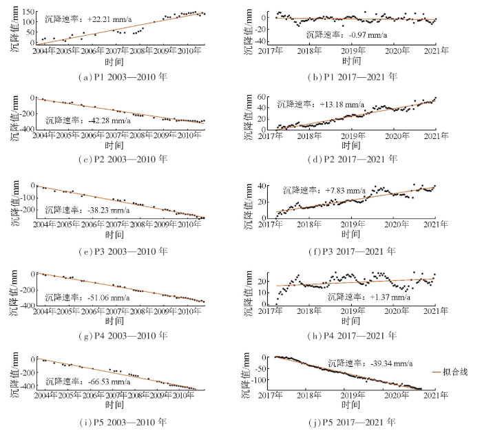
图6
2个时段5个沉降中心的沉降时间序列
Fig.6
Time series of displacement in 5 subsidence centers in two periods
表1 5个沉降中心在2个时间段的年平均沉降速率及变化
Tab. 1
| 点号 | 地区 | (mm· a-1) | (mm· a-1) | ΔV/ (mm· a-1) | 状态变化 |
|---|---|---|---|---|---|
| P1 | 西张-北固碾村 | +22.21 | -0.97 | -23.18 | 抬升→稳定 |
| P2 | 万柏林-良源小区 | -42.28 | +13.18 | +55.46 | 沉降→抬升 |
| P3 | 下元-华景苑 | -38.23 | +7.83 | +46.06 | 沉降→抬升 |
| P4 | 吴家堡-悦泉苑 | -51.06 | +1.37 | +52.43 | 沉降→抬升 |
| P5 | 小店-富士康 科技园 | -66.53 | -39.34 | +27.19 | 沉降速率减小 |
对比2003—2010和2017—2021时段,从图6和表1可以看出,太原北部的西张—北固碾村(P1)由地面抬升转为稳定,由抬升速率+22.21 mm/a变为-0.97 mm/a。中部城区包括万柏林—良源小区(P2)、下元—华景苑(P3)和吴家堡-悦泉苑(P4)由地面沉降转为抬升,平均的形变速率变化量
3.3 太原市地面沉降与地下水开采的关系分析
基于山西省水资源公报,获取了太原市地下水开采量以及“引黄入晋”工程引水量,如图7所示。从图7可以看出,1996—2002年,太原市地下水开采量呈逐年上升趋势,至2002年地下水开采量达到最高峰,为4.62亿m3。这一阶段对应于太原市地面沉降持续急剧扩展阶段[3]。之后,地下水开采量虽然在2005—2006年有所回升,但总体上呈逐年下降的趋势。这一阶段对应太原市地面沉降逐渐减缓的阶段。至2021年,地下水开采量降为2.01亿m3,不足2002年最高峰时的50%。这主要归功于太原市实施的水源置换、关井压采等措施。从图7中看出,太原市2007—2020年每年引入的黄河水量呈逐渐增加的趋势,2020年达到2.8亿m3。通过引黄补水,有效缓解了太原市水资源短缺问题,地下水开采减少,地下水位持续回升(图7中红色线)。
图7
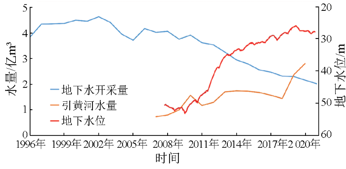
图7
太原市地下水开采量、“引黄入晋”引水量和地下水位
Fig.7
The amount of groundwater extraction, “Diversion of Yellow River into shanxi” water diversion and the groundwater level in Taiyuan City
为了定量化比较地表形变与地下水位的关系,本文获取了太原水位站点(图4(b)中的TY点)地下水位数据并与2个时段的地表形变进行比较,如图8所示。从图8可看出,该点处地下水位在2007—2010年期间趋于稳定,此后逐年上升,2010—2013年上升显著。2007—2021年地下水位总体回升了23 m,上升速率为+2.3 mm/a。2003—2010年,ENVISAT观测到该站点处地表形变表现为微弱的沉降(-1.5 mm/a); 2017—2021年,Sentinel-1观测到该站点处地表形变表现为微弱的抬升(+1.3 mm/a)。虽然该站点没有位于太原市地面沉降严重的区域,但从2个时段内的地表变形趋势看,这种变形的转变受地下水位变化的控制作用明显。太原市地面沉降主要是长期高强度开采地下水,使含水层中孔隙压力减少,土地有效应力增加,含水层土体发生压实,传到地表表现为高程降低,即地面沉降。当地下水位回升时,含水层孔隙压力恢复,有效应力降低,进而引起被压实的含水层系统弹性松弛,导致地表抬升,这种现象称为弹性或孔隙弹性反弹。
图8
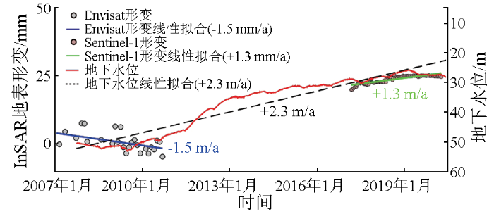
图8
太原市地下水位与地表形变对比
Fig.8
Comparison of groundwater level and surface deformation in Taiyuan City
4 结论
本文基于PS-InSAR技术,处理了2003—2010年39期ENVISAT影像和2017—2021年113期Sentinel-1影像,获得太原市地面沉降速率及其时间序列变化。通过对比2个时间段地面沉降的时空变化,并与太原市地下水位开采量、“引黄入晋”工程引水量及地下水位数据进行对比研究,得出以下结论:
1)2003—2010年,太原市地面沉降集中于城区和南部小店区。城区形成了吴家堡、下元、万柏林沉降中心; 南部的小店区沉降最为严重,最大沉降速率达到78 mm/a; 北部西张老沉降区表现为地表抬升。2017—2021年,太原市城区沉降中心已由地面沉降演变为地面抬升,抬升速率达到20 mm/a; 南部小店区沉降面积增大,地面沉降速率减弱,沉降中心南移; 北部西张老沉降区地表趋于稳定。
2)2017—2021年与2003—2010年相比,万柏林沉降中心变化最显著,由-42.28 mm/a变为+13.18 mm/a,这与万柏林地区的黏性土层数多、累计厚度较大有关。
3)太原地面沉降趋缓甚至出现抬升的主要原因是地下水位的持续回升。地下水位恢复,使含水层孔隙压力增加,有效应力降低,进而引起被压实的含水层系统弹性松弛,导致地表抬升。这种转变充分说明太原市地下水超采治理取得显著成效,部分地区实现采补平衡,地下水生态环境得到明显改善。
参考文献
山西太原盆地地裂缝与地下水开采、地面沉降关系分析
[J].
Relationship between ground fissures,groundwater exploration and land subsidence in Taiyuan Basin
[J].
太原市地层空间异质性对地面沉降分布的影响
[J].
Effect of strata heterogeneity on spatial pattern of land subsidence in Taiyuan City
[J].
太原市地面沉降发展概况及其危害
[J].
General situation and harm of land subsidence in Taiyuan City
[J].
国内外地面沉降现状与研究
[J].
Domestic and international recent situation and research of land subsidence disasters
[J].
Sentinel-1A京津冀平原区2016—2018年地面沉降InSAR监测
[J].
Monitoring of land subsidence in Beijing-Tianjin-Hebei Plain during 2016—2018 based on InSAR and Sentinel-1A data
[J].
北京东部平原区地面沉降时空演化特征及预测
[J].
Spatial-temporal evolution characteristics and prediction of land subsidence in the eastern plain of Beijing
[J].
太原盆地地面沉降时序InSAR监测与季节性变形小波分析
[J].
Monitoring land subsidence by time series InSAR and wavelet analysis of seasonal deformation in Taiyuan Basin
[J].
Permanent scatterers in SAR interferometry
[J].
永久散射体雷达干涉测量技术
[J].
Progress of permanent scatterer interferometry
[J].
Nonlinear subsidence rate estimation using permanent scatterers in differential SAR interferometry
[J].
A small-baseline approach for investigating deformations on full-resolution differential SAR interferograms
[J].
A new algorithm for surface deformation monitoring based on small baseline differential SAR interferograms
[J].
Persistent scatterer interferometric synthetic aperture radar for crustal deformation analysis,with application to Volcán Alcedo,Galápagos
[J].
Dynamics of slow-moving landslides from permanent scatterer analysis
[J].
PMID:15218146

High-resolution interferometric synthetic aperture radar (InSAR) permanent scatterer data allow us to resolve the rates and variations in the rates of slow-moving landslides. Satellite-to-ground distances (range changes) on landslides increase at rates of 5 to 7 millimeters per year, indicating average downslope sliding velocities from 27 to 38 millimeters per year. Time-series analysis shows that displacement occurs mainly during the high-precipitation season; during the 1997-1998 El Niño event, rates of range change increased to as much as 11 millimeters per year. The observed nonlinear relationship of creep and precipitation rates suggests that increased pore fluid pressures within the shallow subsurface may initiate and accelerate these features. Changes in the slope of a hill resulting from increases in the pore pressure and lithostatic stress gradients may then lead to landslides.
华北地区的水平运动场与昆仑山8.1级地震的可能关系
[J].
Possible relation of horizontal movement field in North China to Kunlun Mountain Ms8.1 earthquake
[J].
Urban-target recognition by means of repeated spaceborne SAR images
[J].
太原市地面沉降的计算与预测
[J].
Computation and prediction of the land subsidence in Taiyuan
[J].
太原市地面沉降数值模拟
[J].
Numerical simulation of land subsidence of Taiyuan City
[J].
基于小基线DInSAR技术监测太原市2003—2009年地表形变场
[J].
Ground deformation monitoring using small baseline DInSAR technique:A case study in Taiyuan City from 2003 to 2009
[J].
A new method for measuring deformation on volcanoes and other natural terrains using InSAR persistent scatterers
[J].
