0 引言
地表形变监测在预防地表沉降、滑坡、地震等相关地质灾害方面发挥着至关重要的作用,可有效降低灾害风险。具体而言,通过对地表形变的持续精准监测,可以及时发现潜在的地质灾害隐患,为灾害预警和应急处置提供科学依据,从而降低灾害发生的可能性和危害程度[1 3] 。合成孔径雷达干涉测量(interferometric synthetic aperture radar, InSAR)技术能够全天候、全天时的以低成本、高空间分辨率和高效率监测大范围的地表形变,具有传统形变监测技术无可比拟的优越性[4 7] 。随着对InSAR技术研究的不断深入,国内外学者先后提出了一系列的时序InSAR方法[6 ,8 10] 。其基本原理是通过对长时间序列覆盖同一区域的SAR影像进行处理,提取后向散射特性较强的高相干点目标的形变信息,理论上的监测精度可达毫米级[11 -12 ] 。
但是,针对人工目标稀少的非城市区域,由于受到去相关的强烈影响,这些传统的时序InSAR技术在实际应用中常常面临难以提取到数量充足且分布密度较高的高相干点目标这一问题[13 ] 。相位解缠是InSAR技术中的关键环节,相干目标不足会导致解缠过程出现错误,进而影响整个形变监测的有效性和可靠性。与永久散射体(persistent scatterer, PS)相比,分布式散射体(dispersion of amplitude, DS)具有更为广泛的空间分布特点,其通常出现在裸地、荒漠以及稀疏植被覆盖区域等[14 -15 ] 。因此,分布式散射体干涉测量技术(DS-InSAR)可以很好地弥补传统时序InSAR技术在非城市区域监测点数量不足的问题,可以为非城市区域的地表形变监测提供更有力的技术支持[16 18] 。
另一方面,受极化SAR干涉测量技术(polarimetric InSAR, PolInSAR)[19 ] 的启发,一些研究人员提出利用多极化SAR影像中包含的极化信息对干涉相位进行优化。因此,Pipia等[20 ] 于2009年基于全极化地基SAR数据成功将极化优化算法应用于PSI技术。随着卫星技术的发展,近年来多极化SAR卫星(TerraSAR-X,ALOS-2,Sentinel-1A,GF-3等)陆续发射升空,获取了大量的多极化SAR数据,为极化SAR干涉测量技术提供了最为坚实的数据基础[21 -22 ] 。利用多极化SAR数据,国内外学者开展了大量的研究工作,提出了多种基于PSI技术的极化优化技术(polarimetric persistent scatterer interferometry, PolPSI)[23 ] 。研究表明,极化通道的极化信息蕴含着丰富的目标特性。所以,通过利用不同极化通道的极化信息,搜索目标的最佳散射机制(scattering mechanism,SM),可以降低SAR像元因去相关引起的干涉相位噪声,优化散射体相位质量,提高监测点的空间密度和相位质量,极大助力在中低相干区的时序形变监测能力[24 27] 。
目前最常用的极化优化方法有最优极化通道(BEST)和遍历搜索极化优化算法(exhaustive search polarimetric optimization, ESPO)等[28 ] 。BEST方法仅在HH,VV和VH极化通道中选择最佳极化通道,该方法简单高效,但并没有充分发挥极化通道的潜力。ESPO则是遍历极化空间的最优解,但计算负担非常高,会限制其在大型场景中的实际应用[29 ] 。通常将相位质量指标振幅离差法(dispersion of amplitude, DA)作为最佳极化通道的判断准则。由于极化优化会导致相邻像元之间的极化方式存在差异,而DS-InSAR中同质像元识别的原理是基于幅度或强度影像以统计推断为手段度量邻域像元与中心像元的相似度进行判断[30 32] ,因此现有的极化优化方法会降低DS点的选取数量。那么如何利用极化信息,提高DS点的数量,将极化优化算法应用于DS-InSAR技术值得进一步的研究。
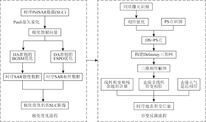
目前,学术界提出了多种PolPSI技术,但是由于DS-InSAR中同质像元识别原理的限制,常用的PolPSI并不适用于DS-InSAR技术,并且计算非常耗时。因此,为了更好地提高InSAR技术在复杂地形的形变监测效果,本文在永久散射体干涉测量技术(PS-InSAR)和DS-InSAR技术的基础上,结合极化优化算法及一种基于群体智能的优化算法,提出了一种顾及DS的高效的极化时序InSAR技术方法,该方法解决同质像元识别原理对极化优化的限制,并大幅提高了极化优化效率。基于本文提出的方法,选取浙江省宁波市部分区域为研究区,使用双极化Sentinel-1数据进行实验,并对极化优化前后的相关结果进行讨论。
1 研究区概况及数据源
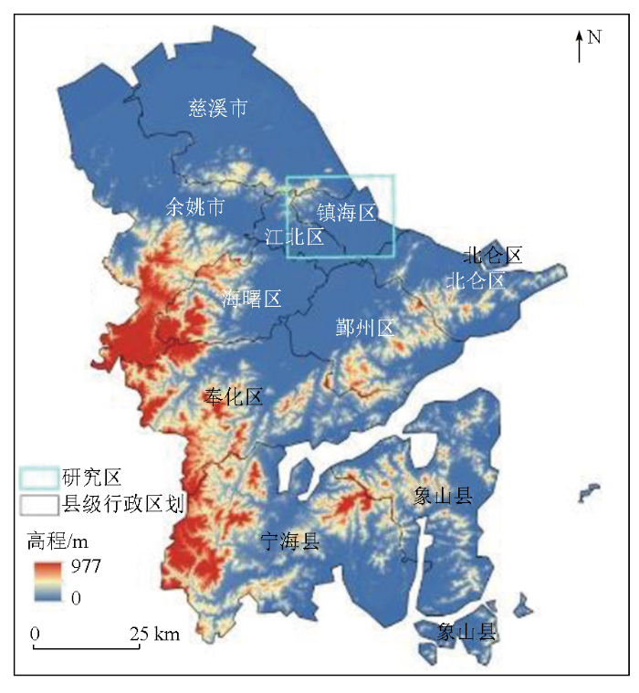
浙江省宁波市地处宁波平原,地势呈现西南高、东北低的特点。该市地貌主要涵盖山脉、丘陵、盆地和平原等类型,其具体的地形分布情况如图1 所示。目前,宁波市以现代化滨海大都市为总体框架,积极建设“全球海洋中心城市”,构建“一核、三湾、六片”发展格局,涵盖对前湾新区、镇海北仑片区、象山港片区和三门湾片区的产业开发。这些地区有不少沿海围垦区,需采取填海造地等方式解决土地资源问题。在未固结的泥沙填土上开展工程建设会导致地面沉降广泛出现[33 ] 。
图1
图1
研究区域地形图
Fig.1
Topographic map of study area
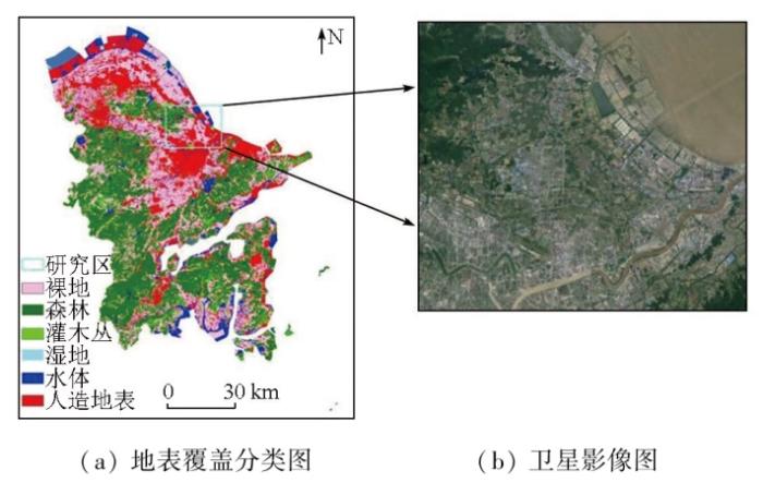
本文使用2022-01-20—2023-12-17间的40景Sentinel-1 IW模式的双极化(VV+VH)数据,首先对数据进行预处理,包括配准、裁剪等操作,得到研究区域的VV,VH这2种极化方式的单视复数(single look complex, SLC)影像,之后基于本研究的方法对宁波市进行时序形变监测。具体研究区为图1 所示的2 000×2 500像元的沿海区域,该区域包含了人造设施及大量裸地、植被等自然地表,地形地貌较为复杂,研究区地表覆盖分类及卫星影像如图2 所示。
图2
图2
研究区地表覆盖分类及卫星影像图
Fig.2
Land cover classification and satellite image map of the study area
2 极化时序InSAR技术
2.1 时序极化优化
在全极化数据下,对于每个SAR像元,散射矩阵S 表示为一个2×2的复矩阵,通常情况下它包含了散射体的完整信息,其目标散射矩阵S [19 ] 如下:
(1) S =$\left[\begin{array}{ll}{S}_{HH}& {S}_{HV}\\ {S}_{VH}& {S}_{VV}\end{array}\right]$ ,
式中: S HH 和S VV 为同极化分量; S VH 和S HV 为交叉极化分量。假设满足互异性,即S HV =S VH ,散射矩阵S 经Pauli基矢量化后可得极化散射向量k [4 ] ,计算公式为:
(2) k =$\frac{1}{\sqrt{2}}{\left[{S}_{HH}+{S}_{VV},{S}_{HH}-{S}_{VV},2{S}_{HV}\right]}^{\mathrm{T}}$ ,
式中: T表示转置。当全极化向双极化转变时,式(2)可转化为:
(3) kVV/VH =$\frac{1}{\sqrt{2}}{\left[{S}_{VV},2{S}_{HV}\right]}^{\mathrm{T}}$ ,
(4) kHH/VH =$\frac{1}{\sqrt{2}}{\left[{S}_{HH},2{S}_{HV}\right]}^{\mathrm{T}}$ ,
(5) kHH/VV =$\frac{1}{\sqrt{2}}{\left[{S}_{HH}+{S}_{VV},{S}_{HH}-{S}_{VV}\right]}^{\mathrm{T}}$ 。
极化优化是一种通过选择受去相关影响最小的极化状态来提高高质量相干点的数量及其相位质量的方法[23 ] ,即通过表征散射机制的复数投影向量ω [25 ] ,在极化空间中遍历使像元质量最佳的极化方式μ ,计算公式为:
(7) $ \omega=\left[\begin{array}{c} \cos \alpha \\ \sin \alpha \cdot \mathrm{e}^{j \vartheta} \end{array}\right] \begin{array}{c} (0 \leqslant \alpha \leqslant \pi / 2) \\ (-\pi \leqslant \vartheta \leqslant \pi) \end{array},$
式中: α ,ϑ 分别为不同散射机制的Pauli参数。
振幅离差指数(DA )是一种常用的相位质量评价指标[11 ,15 ] ,表示为时间序列上同一像元的振幅A 的标准差σA 与均值$\stackrel{-}{A}$ DA 表示为:
(8) DA =$\frac{{\sigma }_{A}}{\stackrel{-}{A}}$ =$\frac{1}{\overline{\left|{\omega }^{†}k\right|}\sqrt{N}}\sqrt{\stackrel{N}{\sum _{i=1}}{(\left|{\omega }^{†}{k}_{i}\right|-\overline{\left|{\omega }^{†}k\right|})}^{2}}$ ,
式中: N 为影像数量; $\left|\stackrel{-}{·}\right|$
因此时序极化优化的主要目的就是在二维空间中搜索使DA 最小的投影向量ω ,求解参数α 和ϑ 。需要指出的是,由于极化优化需要遍历每个SAR像元的所有极化空间,计算成本较高,会限制其在大型场景中的实际应用。
2.2 双极化时序InSAR形变监测
不同于以往的PolPSI技术,为了进一步提高监测点的密度,本文将DS-InSAR引入时序极化优化中。根据DS点选取受邻域像元影响的问题,本文将时序SAR数据的强度信息和相位信息分别使用不同的极化优化方法,以此得到极化优化后的SLC影像,并使用优化后的影像联合PS点和DS点进行地表形变监测,具体流程如图3 所示。
图3
图3
双极化时序InSAR形变监测处理流程
Fig.3
Processing flow of dual-polarization time-series InSAR deformation monitoring
首先,为不影响DS点的选取,根据同质像元识别的原理可知,规定所有SAR像元必须在同一极化状态下,因此针对时序SAR影像的强度信息,本文采用全局优化策略,即最佳全局散射机制(best global scattering mechanism, BGSM)法[34 ] 。该方法的原理是针对整个SAR影像数据对极化空间进行搜索,并通过最小化整个影像的的平均值找到对于全局最优的投影向量ω 。该方法的优势在于规定了整幅影像都在同一极化状态下,不会改变邻域像元的相似度,能够提高同质像元识别数量。
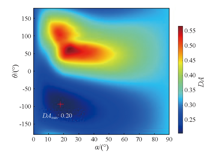
其次,为最大程度降低SAR数据的相位噪声,提高相位质量,针对时序SAR影像的相位数据,逐像元进行极化优化处理。ESPO方法[35 ] 对每个像元在整个极化空间上执行二维搜索,通过使每个像元的DA 最小找到最优极化状态,图4 展示了某SAR像元的极化空间参数搜索结果。但是,该方法的搜索耗时是一个不可否认的缺点。因此,为了减轻负担,本文在ESPO算法的基础上,将粒子群优化(particle sswarm optimization, PSO)算法加入其中,使其能够快速找到近似最优的极化空间,而不必遍历所有可能的情况,以提高算法的运行效率。
图4
图4
SAR像元的极化空间参数搜索结果
Fig.4
Search results of polarization space parameters of SAR pixels
最后基于双极化优化得到的SLC影像,联合PS和DS技术,进行时序地表形变监测,并对监测结果进行讨论与分析。
3 结果与分析
为分析极化优化对PS点和DS点选取数量的提升效果,实验分别对比分析了2种方法在识别PS点的过程中不同阈值下的点数量,以及同质像元识别结果和最终DS点的选点结果。
3.1 算法性能评估
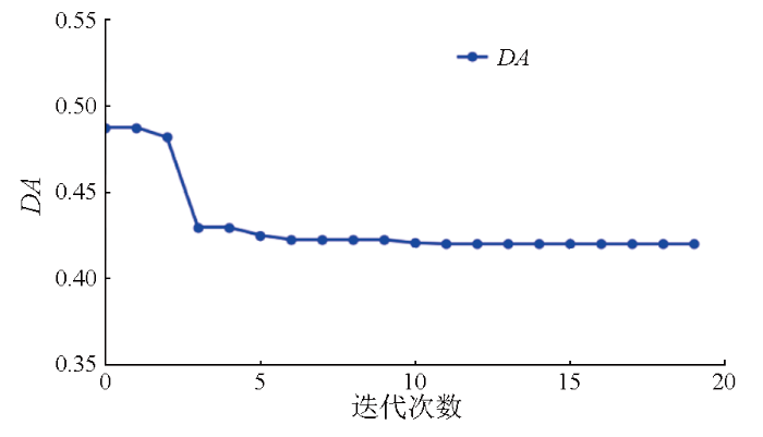
为了验证加入PSO算法对运行效率的提升,分别针对单个像元及研究区整体运行时间及运算结果进行分析。电脑配置为12th Gen Intel(R) Core(TM) i7-12 700单线程运算,对于单一像元[566,1 151],在设置ESPO方法搜索步长为3°情况下,运行时间为0.08 s,最小DA值为0.4 198; 加入PSO算法后,在设置粒子数5,迭代次数20的情况下,同一像元的优化时间为0.003 s,最小DA值为0.4 196,其具体迭代情况如图5 所示。对于研究区整体来说,其大小为2 000×2 500像元,在设置参数不变的前提下,ESPO方法预计需要120 h,而PSO算法仅需2.5 h。由此可以看出PSO算法能够极大提高极化优化效率,且求出的最小DA值也要优于ESPO方法。为了更合理地设置PSO算法的参数,以提高运行效率,经过多次实验得出,在设置粒子数5,迭代次数10的情况下,绝大多数像元均能达到收敛状态,因此在接下来的实验中,PSO算法采用该参数设置。
图5
图5
PSO算法收敛性分析
Fig.5
Convergence analysis of the PSO algorithm
3.2 选点结果分析
为了深入分析VV极化与极化优化后这2种不同数据对PS点识别所产生的影响,本实验基于振幅离差(DA )对PS点的选取结果进行分析。通常情况下,相干目标的后向散射性越强,其在时序上的表现就会越稳定,相应的DA 值也就越小。所以,那些DA 低于特定阈值的点,便可以被选作PS点。通过这样的方式,可以更加准确地识别出具有稳定后向散射特性的PS点,从而为后续的形变监测和分析提供可靠的数据基础。同时,不同的极化方式和极化优化处理会对相干目标的后向散射性产生不同的影响,进而影响到PS点的选取结果。因此,对这2种不同数据下的PS点识别进行分析,有助于更好地理解极化和极化优化在InSAR形变监测中的作用,为进一步提高形变监测的精度和可靠性提供有益的参考。
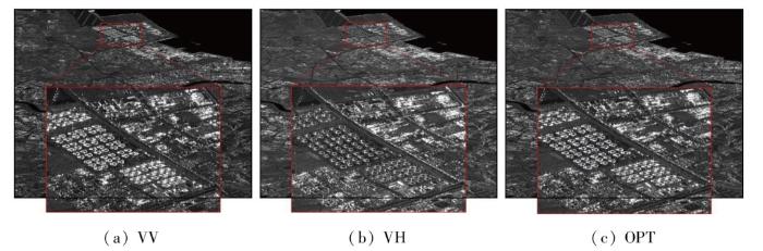
研究表明,经极化优化后,强度影像的旁瓣效应与噪声均在一定程度上有所减轻。图6 呈现了VV,VH,极化优化后(OPT)这3种方式获取的时序平均强度图,从红色方框内放大的子区域能够更清晰地看出,VV极化因人工建筑等强散射体对周围弱散射体回波信号产生严重干扰,致使建筑物边界模糊; VH极化因强弱散射体回波信号均较弱,使得地物难以辨别; 而极化优化处理有力地抑制了旁瓣效应,提升了不同地物间的对比度。
图6
图6
不同极化方式下的平均强度图
Fig.6
Plot of average intensity for different polarisation models
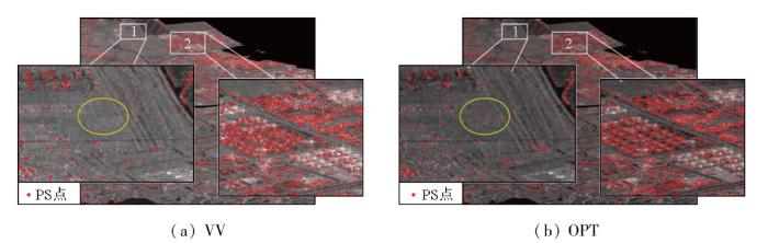
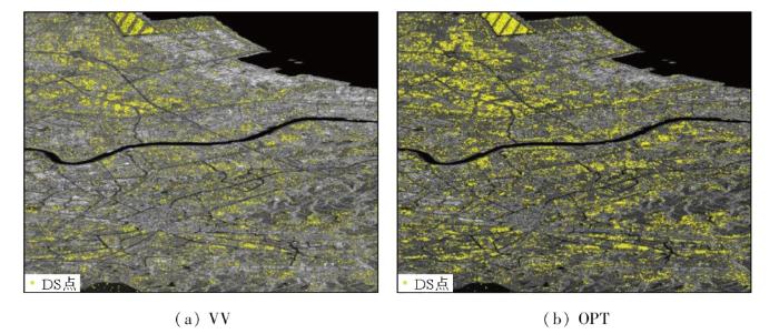
为定性分析极化优化对提高PS点数量的效果,选取研究区中的2种典型区域进行研究,如图7 所示,分别为裸地、农田区域(白框1)和工厂厂区(白框2),其中底图为研究区的平均强度图,红色点表示PS点,框1中PS点个数分别为1 033和1 167个,框2中分别为15 078和15 830个。根据图7 分析: 针对裸地、农田区域,通过黄色圆圈对比分析可知,极化优化能够提高PS点的数量,这是由于该区域在SAR影像分辨单元内存在大量的散射体导致散射回波信号较弱,通过双极化优化寻找最优散射机制,有利于改善SAR影像分辨单元的散射回波信号,因此极化优化能够作用于该区域。但是对于工厂厂区,极化优化并没有体现出很好的效果,这是因为在人工建筑物较多的区域,散射回波信号强,SAR分辨单元本来就具有较高的稳定性。其次,为定量分析极化优化对提高PS点数量的效果,不同阈值下点数量的统计结果如表1 所示。在不同的DA 指标范围下极化优化后选取的点数量均多于VV极化,并且优化效果明显,在阈值设为0.4时,PS点数量能够提升约20%。
图7
图7
2种典型区域的PS点数量对比
Fig.7
Comparison of the number of PS points in 2 typical areas
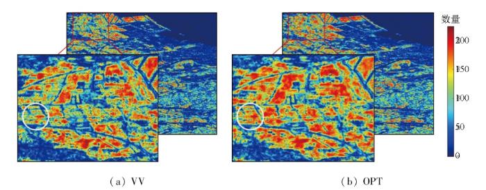
为分析VV极化与极化优化2种不同数据对DS点识别的影响,实验分别对同质像元识别结果和最终DS点的选点结果分析讨论。图8 分别显示了2种方法得到的同质像元识别数量分布图。结合图2 进行分析可以看出,地表覆盖类型会对同质像元的识别产生影响。以城市区域为例,城市的建筑物散射特性较强,导致选取的同质像元数量相对较少。相比之下,裸地或低矮植被覆盖区域等属于典型的分布式目标集中区域,所以在这些地方选取的同质像元数量会比较多。由此可见,不同的地表覆盖类型具有不同的散射特性,进而影响了同质像元的识别结果。为了更直观地对比优化的效果,实验选择红框区域进行对比分析,通过图8 对比分析可得: 极化优化能够显著提高同质像元识别的数量,并且能够提高同质像元识别的准确性。如图8 中白圈区域所示,(b)中该区域的同质像元数量明显高于(a),并且地物框架则十分明显,说明此时同质像元和异质像元能够被很好地区分。
图8
图8
同质像元识别数量对比
Fig.8
Comparison of the number of identified homogeneous pixels
之后基于同质像元识别结果,进行DS点选择。DS识别分布对比如图9 所示,其中底图为研究区的平均强度图,黄色点表示DS点。经统计得出,VV极化下DS点数量为358 869个,而极化优化处理后识别出的DS点数量为565 117,增长了约57.5%。
图9
图9
DS点识别分布对比图
Fig.9
Comparison diagram of DS point identification distribution
3.3 差分干涉图结果分析
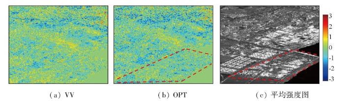
选取一幅长时间基线(20230103—20221128)的差分干涉图进行质量评价。分析区域位于研究区东部沿海码头区域。图10(a)(b) 分别显示了VV极化差分干涉图和极化优化后的差分干涉图,图10(c) 为对应区域的平均强度图,红色虚线显示该码头的范围。通过对比优化前后的差分干涉图能够明显看出,极化优化后的干涉图条纹要比原始干涉图清晰得多。在原始干涉图中,码头内部构筑物的边缘区域干涉相位十分模糊,经过优化之后,能够降低差分干涉图的噪声水平,从而使得构筑物的轮廓更加清晰可见。
图10
图10
局部区域干涉图优化前后对比
Fig.10
Comparison of local area interferograms before and after optimization
为定量分析极化优化对差分干涉图的优化效果,选用定量指标对差分干涉图质量进行评价。基于优化前后的差分干涉图,分别计算其残差点数(residue point number, RPN)、相位差之和(sum of phase differences, SPD)及干涉相干性(coherence, COH)。RPN和SPD越小,表明干涉图的质量越好。采用[15×15]规则窗口分别对优化前后的差分干涉图进行相干性估计,COH越大,对干涉图的优化效果越好。表2 显示了在不同时间基线下,极化优化对差分干涉图的优化效果。结果表明: 极化优化对于长时间基线,使干涉图的RPN和SPD分别降低了11.1%和4.9%,使干涉图的COH提高了11.4%; 对于短时间基线,使干涉图的RPN和SPD分别降低了13.5%和6.2%,使干涉图的COH提高了15.2%。
3.4 形变监测结果分析
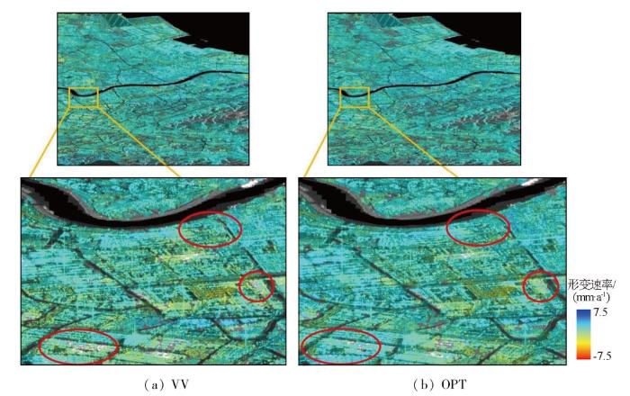
图11 为利用VV极化数据和极化优化后数据进行时序InSAR形变监测获得的研究区地表形变结果,方框中为宁波市鄞州区部分区域的地表形变速率结果。对比2种方法获得的整体形变趋势结果与已有研究数据[33 ,36 ] 的平均沉降速率基本一致,且极化优化后的形变监测结果的监测点的密度更高,说明在该区域极化优化技术能够更加详细地反映区域形变状况。
图11
图11
研究区地表形变速率图
Fig.11
Surface deformation rate map of the study area
从图11 的3处红圈区域更加清晰地看出,在极化优化之后,由于形变监测点的密度较大,所以所反演出来的形变细节也更为清晰。此外,在最左侧红圈区域中2种方法的监测形变结果呈现出显著的差异,产生这种差异的主要原因是在时间序列InSAR相位解缠的过程中,相干目标需事先构建空间网络,之后再进行模糊度解算,而空间网络的构建方式会直接影响到后续模糊度解算的准确性,进而对形变监测的结果产生很大的影响。目前Delaunay三角网是当前时序相位解缠的主流构网方法,评价构网质量的主要指标有三角网的密度以及三角网边的相位梯度大小,若网络形态包含高相位梯度边缘,导致违背相位连续性假设,会对形变监测结果产生较大影响[37 ] 。通过前文的分析可知,经极化优化处理后得到的形变监测点的数量及其相位质量都有明显的提升,因此优化后使得相干目标的连接更加紧密,构建的三角网密度更大,效果更好,能够更加准确地捕捉到细微的形变变化,可以更详细地反演真实地表形变,从而提高了地表形变监测能力。
4 结论
为了进一步提高InSAR技术在复杂区域的形变监测能力,针对提高高相干点数量和干涉相位质量进行研究,提出了一种估计DS的极化时序InSAR技术方法,并以浙江省宁波市为例,对比分析单极化方法与本文方法的形变监测效果,结论如下:
1)通过加入PSO算法,大幅提高极化优化的运算效率,比ESPO方法时间减少约48倍。
2)本文所提的方法能很好地保持PS目标分辨率,提高PS点数量,并提升DS点识别的准确性和数量,相较单极化数据,DS点增幅达57.5%。
3)通过对相位数据的优化,能够明显提升差分干涉相位图的质量,干涉平均相干性能够提升15%以上。
4)通过提高监测点密度及其干涉相位质量,可以得到更详细的研究区地表形变监测结果,为提高InSAR技术在复杂区域监测效果的问题提供了一种新的思路和方法。
参考文献
View Option
[1]
Zhu C H Wang C S Zhang B C et al . Differential interferometric synthetic aperture radar data for more accurate earthquake catalogs
[J]. Remote Sensing of Environment , 2021 ,266:112690.
[本文引用: 1]
[2]
Cigna F Tapete D . Present-day land subsidence rates,surface faulting hazard and risk in Mexico City with 2014-2020 Sentinel-1 IW InSAR
[J]. Remote Sensing of Environment , 2021 ,253:112161 .
[3]
Liu Y F Yang H L Wang S Z et al . Monitoring and stability analy-sis of the deformation in the woda landslide area in Tibet,China by the DS-InSAR method
[J]. Remote Sensing , 2022 , 14 (3 ):532 .
DOI:10.3390/rs14030532
URL
[本文引用: 1]
The Woda area in the upper Jinsha River has steep terrain and broken structures, causing landslide disasters frequently. Here, we used the distributed scatterer interferometric SAR (DS-InSAR) method to monitor and analyze the Woda landslide area. With the DS-InSAR method, we derived the deformation of the Woda landslide area from 106 Sentinel-1A ascending images acquired between 5 November 2014 and 4 September 2019 and 102 Sentinel-1A descending images acquired between 31 October 2014 and 11 September 2019. The obvious advantage of the DS-InSAR method compared to the persistent scatterer (PS) InSAR (PS-InSAR) method is that the densities of the monitoring points were increased by 25.1% and 22.9% in the ascending and descending images, respectively. The two-dimensional deformation of the landslide area shows that the maximum surface deformation rate in the normal direction was −80 mm/yr, and in the east–west direction, 118 mm/yr. According to the rescaled range (R/S) analysis, the Hurst index values of the deformation trends were all greater than 0.5, which means the deformation trend will continue for some time. In addition, we analyzed the influencing factors and the deformation mechanism of the Woda landslide area and found that the surface deformation is closely related to the geological structure and precipitation, among which precipitation is the main factor triggering the deformation. Our monitoring results will help the local government to conduct regular inspections and strengthen landslide disaster prevention in low-coherence mountainous areas.
[4]
Zhao F Wang T Zhang L X et al . Polarimetric persistent scatterer interferometry for ground deformation monitoring with VV-VH sentinel-1 data
[J]. Remote Sensing , 2022 , 14 (2 ):309 .
DOI:10.3390/rs14020309
URL
[本文引用: 3]
With the launch of the Sentinel-1 satellites, it becomes easy to obtain long time-series dual-pol (i.e., VV and VH channels) SAR images over most areas of the world. By combining the information from both VV and VH channels, the polarimetric persistent scatterer interferometry (PolPSI) techniques is supposed to achieve better ground deformation monitoring results than conventional PSI techniques (using only VV channel) with Sentinel-1 data. According to the quality metric used for polarimetric optimizations, the most commonly used PolPSI techniques can be categorized into three main categories. They are PolPSI-ADI (amplitude dispersion index as the phase quality metric), PolPSI-COH (coherence as the phase quality metric), and PolPSI-AOS (taking adaptive optimization strategies). Different categories of PolPSI techniques are suitable for different study areas and with different performances. However, the study that simultaneously applies all the three types of PolPSI techniques on Sentinel-1 PolSAR images is rare. Moreover, there has been little discussion about different characteristics of the three types of PolPSI techniques and how to use them with Sentinel-1 data. To this end, in this study, three data sets in China have been used to evaluate the three types of PolPSI techniques’ performances. Based on results obtained, the different characteristics of PolPSI techniques have been discussed. The results show that all three PolPSI techniques can improve the phase quality of interferograms. Thus, more qualified pixels can be used for ground deformation estimation by PolPSI methods with respect to the PSI technique. Specifically, this pixel density improvement is 50%, 12%, and 348% for the PolPSI-ADI, PolPSI-COH, and POlPSI-AOS, respectively. PolPSI-ADI is the most efficient method, and it is the first choice for the area with abundant deterministic scatterers (e.g., urban areas). Benefitting from its adaptive optimization strategy, PolPSI-AOS has the best performances at the price of highest computation cost, which is suitable for rural area applications. On the other hand, limited by the medium resolution of Sentinel-1 PolSAR images, PolPSI-COH’s improvement with respect to conventional PSI is relatively insignificant.
[5]
Blanco-Sánchez P Mallorquí J J Duque S et al . The coherent pixels technique (CPT):An advanced DInSAR technique for nonlinear deformation monitoring
[J]. Pure and Applied Geophysics , 2008 , 165 (6 ):1167 -1193 .
DOI:10.1007/s00024-008-0352-6
URL
[6]
Ferretti A Prati C Rocca F . Permanent scatterers in SAR interferometry
[C]// Proceedings of SAR Image Analysis,Modeling,and Techniques II. SPIE-International Society for Optical Engineering , 1999 :132 -139 .
[本文引用: 1]
[7]
安炳琪 , 罗海滨 , 丁海勇 , 等 . 基于SBAS-InSAR技术的西宁地表形变监测
[J]. 遥感技术与应用 , 2021 , 36 (4 ) :838 -846 .
DOI:10.11873/j.issn.1004-0323.2021.4.0838
[本文引用: 1]
地表形变引发的地质灾害给自然环境和社会带来了巨大威胁,小基线集合成孔径雷达干涉测量(SBAS-InSAR)技术以其监测精度高、监测范围大和非接触等优势,成为地表形变监测的重要手段,为预防地质灾害发生、降低灾害损失,实现地表形变有效监测具有重要意义。利用SBAS-InSAR技术对青海省西宁市2018年1月7日至11月27日27景Sentinel-1A数据进行处理,得到西宁市地表平均形变速率分布图。与同期8个西宁南山GPS地面观测点比较,除一个点误差较大外,其余7个点均方根误差都在3 mm以内,证明了SBAS-InSAR监测结果的可靠性。SBAS-InSAR监测结果表明:山体滑坡是西宁市地表形变的主要形式,特别是沿互助北山和G6京藏高速公路一带滑坡运动尤为明显。实验首次获取了西宁市火车站东北滑坡灾害点定量形变数据,为分析该灾害点状况、保障西宁火车站安全运行提供有价值的参考。
An B Q Luo H B Ding H Y et al . Monitoring of surface deformation in Xining based on SBAS-InSAR
[J]. Remote Sensing Technology and Application , 2021 , 36 (4 ):838 -846 .
[本文引用: 1]
[8]
Ferretti A Prati C Rocca F . Nonlinear subsidence rate estimation using permanent scatterers in differential SAR interferometry
[J]. IEEE Transactions on Geoscience and Remote Sensing , 2000 , 38 (5 ):2202 -2212 .
DOI:10.1109/36.868878
URL
[本文引用: 1]
[9]
Zhang L Lu Z Ding X L et al . Mapping ground surface deformation using temporarily coherent point SAR interferometry:Application to Los Angeles Basin
[J]. Remote Sensing of Environment , 2012 ,117:429 -439 .
[10]
Fan H D Gao X X Yang J K et al . Monitoring mining subsidence using a combination of phase-stacking and offset-tracking methods
[J]. Remote Sensing , 2015 , 7 (7 ):9166 -9183 .
DOI:10.3390/rs70709166
URL
[本文引用: 1]
An approach to study the mechanism of mining-induced subsidence, using a combination of phase-stacking and sub-pixel offset-tracking methods, is reported. In this method, land subsidence with a small deformation gradient was calculated using time-series differential interferometric synthetic aperture radar (D-InSAR) data, whereas areas with greater subsidence were calculated by a sub-pixel offset-tracking method. With this approach, time-series data for mining subsidence were derived in Yulin area using 11 TerraSAR-X (TSX) scenes from 13 December 2012 to 2 April 2013. The maximum mining subsidence and velocity values were 4.478 m and 40 mm/day, respectively, which were beyond the monitoring capabilities of D-InSAR and advanced InSAR. The results were compared with the GPS field survey data, and the root mean square errors (RMSE) of the results in the strike and dip directions were 0.16 m and 0.11 m, respectively. Four important results were obtained from the time-series subsidence in this mining area: (1) the mining-induced subsidence entered the residual deformation stage within about 44 days; (2) the advance angle of influence changed from 75.6° to 80.7°; (3) the prediction parameters of mining subsidence; (4) three-dimensional deformation. This method could be used to predict the occurrence of mining accidents and to help in the restoration of the ecological environment after mining activities have ended.
[11]
何倩 . 联合PS和DS的时序InSAR地表沉降监测方法研究 [D]. 徐州 : 中国矿业大学 , 2022 .
[本文引用: 2]
He Q . Study on time-series InSAR method for monitoring surface subsidence with persistent and distributed scatterers [D]. Xuzhou : China University of Mining and Technology , 2022 .
[本文引用: 2]
[12]
Huang J L Bai Y Lei S G et al . Time-series SBAS pixel offset tracking method for monitoring three-dimensional deformation in a mining area
[J]. IEEE Access , 2020 ,8:118787 -118798 .
[本文引用: 1]
[13]
张路 , 廖明生 , 董杰 , 等 . 基于时间序列InSAR分析的西部山区滑坡灾害隐患早期识别——以四川丹巴为例
[J]. 武汉大学学报(信息科学版) , 2018 , 43 (12 ):2039 -2049 .
[本文引用: 1]
Zhang L Liao M S Dong J et al . Early detection of landslide hazards in mountainous areas of West China using time series SAR interferometry—a case study of Danba,Sichuan
[J]. Geomatics and Information Science of Wuhan University , 2018 , 43 (12 ):2039 -2049 .
[本文引用: 1]
[14]
Ferretti A Fumagalli A Novali F et al . A new algorithm for processing interferometric data-stacks:SqueeSAR
[J]. IEEE Transactions on Geoscience and Remote Sensing , 2011 , 49 (9 ):3460 -3470 .
DOI:10.1109/TGRS.2011.2124465
URL
[本文引用: 1]
[15]
赵立峰 . 基于DS-InSAR的矿区地表形变监测方法研究——以沛北矿区为例 [D]. 徐州 : 中国矿业大学 , 2022 .
[本文引用: 2]
Zhao L F . Study on surface deformation monitoring method based on DS-InSAR in mining area [D]. Xuzhou : China University of Mining and Technology , 2022 .
[本文引用: 2]
[16]
Goel K Adam N . A distributed scatterer interferometry approach for precision monitoring of known surface deformation phenomena
[J]. IEEE Transactions on Geoscience and Remote Sensing , 2014 , 52 (9 ):5454 -5468 .
DOI:10.1109/TGRS.2013.2289370
URL
[本文引用: 1]
[17]
Li T T Zhang H Z Fan H D et al . Position inversion of goafs in deep coal seams based on DS-InSAR data and the probability integral methods
[J]. Remote Sensing , 2021 , 13 (15 ):2898 .
DOI:10.3390/rs13152898
URL
The goafs caused by coal mining cause great harm to the surface farmland, buildings, and personal safety. The existing monitoring methods cost a lot of workforce and material resources. Therefore, this paper proposes an inversion approach for establishing the locations of underground goafs and the parameters of the probability integral method (PIM), thus integrating distributed scatter interferometric synthetic aperture radar (DS-InSAR) data and the PIM. Firstly, a large amount of surface deformation observation data above the goaf are obtained by DS-InSAR, and the line-of-sight deformation is regarded as the true value. Secondly, according to the obtained surface deformations, the ranges of eight goaf location parameters and three PIM parameters are set. Thirdly, a correlation function between the surface deformation and the underground goaf location is constructed. Finally, a particle swarm optimization algorithm is used to search for the optimal parameters in the range of the set parameters to meet the requirement for minimum error between the surface deformation calculated by PIM and the line-of-sight deformation obtained by DS-InSAR. These optimal parameters are thus regarded as the real values of the position of the underground goaf and the PIM parameters. The simulation results show that the maximum relative error between the position of the goaf and the PIM parameters is 2.11%. Taking the 93,604 working face of the Zhangshuanglou coal mine in the Peibei mining area as the research object and 12 Sentinel-1A images as the data source, the goaf location and PIM parameters of the working face were successfully inverted. The inversion results show that the maximum relative error in the goaf location parameters was 16.61%, and the maximum relative error in the PIM parameters was 26.67%.
[18]
Chen B Q Yang J L Li Z H et al . A new sequential homogeneous pixel selection algorithm for distributed scatterer InSAR
[J]. GIScience & Remote Sensing , 2023 , 60 (1 ):31 .
[本文引用: 1]
[19]
Cloude S R Papathanassiou K P . Polarimetric SAR interferometry
[J]. IEEE Transactions on Geoscience and Remote Sensing , 1998 , 36 (5 ):1551 -1565 .
DOI:10.1109/36.718859
URL
[本文引用: 2]
[20]
Pipia L Fabregas X Aguasca A et al . Polarimetric differential SAR interferometry:First results with ground-based measurements
[J]. IEEE Geoscience and Remote Sensing Letters , 2009 , 6 (1 ):167 -171 .
DOI:10.1109/LGRS.2008.2009007
URL
[本文引用: 1]
[21]
赵峰 , 张雷昕 , 王腾 , 等 . 城市地表形变的双极化Sentinel-1数据极化时序InSAR技术监测
[J]. 武汉大学学报(信息科学版) , 2022 , 47 (9 ):1507 -1514 .
[本文引用: 1]
Zhao F Zhang L X Wang T et al . Polarimetric persistent scatterer interferometry for urban ground deformation monitoring with sentinel-1 dual polarimetric data
[J]. Geomatics and Information Science of Wuhan University , 2022 , 47 (9 ):1507 -1514 .
[本文引用: 1]
[22]
Iglesias R Fabregas X Aguasca A . A new technique for Atmospheric Phase Screen(APS) compensation based on a 2D MultiplernRegression Model in Ground-Based SAR
[C]// 9th European Conference on Synthetic Aperture Radar.Nuremberg,Germany:VDE Verlag GMBH , 2012 :12 -15 .
[本文引用: 1]
[23]
冯瀚 , 赵峰 , 汪云甲 , 等 . 双极化Sentinel-1数据极化时序InSAR技术地表形变监测——以上海市浦东机场为例
[J]. 遥感学报 , 2022 , 26 (12 ):2531 -2541 .
[本文引用: 2]
Feng H Zhao F Wang Y J et al . Dual-polarization Sentinel-1 data polarization time series InSAR technology surface deformation monitoring—Taking Shanghai Pudong airport as an example
[J]. National Remote Sensing Bulletin , 2022 , 26 (12 ):2531 -2541 .
DOI:10.11834/jrs.20210423
URL
[本文引用: 2]
[24]
Navarro-Sanchez V D Lopez-Sanchez J M Vicente-Guijalba F . A contribution of polarimetry to satellite differential SAR interferometry:Increasing the number of pixel candidates
[J]. IEEE Geoscience and Remote Sensing Letters , 2010 , 7 (2 ):276 -280 .
DOI:10.1109/LGRS.2009.2033013
URL
[本文引用: 1]
[25]
Iglesias R Monells D Fabregas X et al . Phase quality optimization in polarimetric differential SAR interferometry
[J]. IEEE Transactions on Geoscience and Remote Sensing , 2014 , 52 (5 ):2875 -2888 .
DOI:10.1109/TGRS.2013.2267095
URL
[本文引用: 1]
[26]
Iglesias R Monells D López-Martínez C et al . Polarimetric optimization of temporal sublook coherence for DInSAR applications
[J]. IEEE Geoscience and Remote Sensing Letters , 2015 , 12 (1 ):87 -91 .
DOI:10.1109/LGRS.2014.2326684
URL
[27]
赵峰 . 面向PSI技术的高质量SAR像元识别与干涉相位极化优化方法研究
[J]. 地理与地理信息科学 , 2020 , 36 (3 ):141 .
[本文引用: 1]
Zhao F . Advanced pixel selection and optimization algorithms for persistent scatterer interferometry (PSI)
[J]. Geography and Geo-Information Science , 2020 , 36 (3 ):141 .
[本文引用: 1]
[28]
Navarro-Sanchez V D Lopez-Sanchez J M . Improvement of persistent-scatterer interferometry performance by means of a polarimetric optimization
[J]. IEEE Geoscience and Remote Sensing Letters , 2012 , 9 (4 ):609 -613 .
DOI:10.1109/LGRS.2011.2176715
URL
[本文引用: 1]
[29]
桂阳归 , 汪长城 , 卢丽君 , 等 . 顾及极化最优的时序双极化InSAR形变监测方法
[J]. 测绘科学 , 2021 , 46 (12 ):75 -82 .
[本文引用: 2]
Gui Y G Wang C C Lu L J et al . A time-series dual-polarization InSAR method based on polarimetric optimization for monitoring deformation
[J]. Science of Surveying and Mapping , 2021 , 46 (12 ):75 -82 .
[本文引用: 2]
[30]
蒋弥 , 丁晓利 , 何秀凤 , 等 . 基于快速分布式目标探测的时序雷达干涉测量方法:以Lost Hills油藏区为例
[J]. 地球物理学报 , 2016 , 59 (10 ):3592 -3603 .
DOI:10.6038/cjg20161007
[本文引用: 1]
针对当前分布式目标雷达干涉测量运算效率低、选点困难等问题,本文提出了一种建立在快速同质点选取下的干涉数据处理框架.相比之前的时序数据处理方法,新方法具有选点快速、自适应性强的特点,能在保留影像分辨率基础之上增加空间点密度.另外,在统计推断的基础上,提出基于无偏空间相干性估计的分布式目标选择方法,进而弥补了传统经验阈值设定的缺陷.本文以美国加州Lost Hills油田区为例,在论证数据处理框架的可行性基础之上,分析了因孔隙流体萃取和孔隙压力降低引起的地表变形.
Jiang M Ding X L He X F et al . FaSHPS-InSAR technique for distributed scatterers:A case study over the lost hills oil field,California
[J]. Chinese Journal of Geophysics , 2016 , 59 (10 ):3592 -3603 .
[本文引用: 1]
[31]
蒋弥 , 丁晓利 , 李志伟 . 时序InSAR同质样本选取算法研究
[J]. 地球物理学报 , 2018 , 61 (12 ):4767 -4776 .
DOI:10.6038/cjg2018L0490
分布式雷达目标时序InSAR技术是目前InSAR形变监测领域的主流方向,其中同质样本选取是该技术的基础,其估计精度直接影响SAR影像分辨率与后续参数解算精度.本文在追踪最新研究进展之上,系统回顾了当今统计同质选点算法的优缺点.在参数与非参数两类统计方法的应用中,采用蒙特卡罗方法和真实数据验证定量比较算法差异以及适用场景.根据之前的研究结论,提出一种改进的最优参数统计同质样本选择方法.最后,论文介绍了团队研发的MATLAB开源工具包,涵盖了同质样本提取和时序InSAR协方差矩阵估计两部分内容,为InSAR科研人员和后续数据处理提供高质量、全分辨率的观测源.
Jiang M Ding X L Li Z W . Homogeneous pixel selection algorithm for multitemporal InSAR
[J]. Chinese Journal of Geophysics , 2018 , 61 (12 ):4767 -4776 .
[32]
Jiang M Yong B Tian X et al . The potential of more accurate InSAR covariance matrix estimation for land cover mapping
[J]. ISPRS Journal of Photogrammetry and Remote Sensing , 2017 ,126:120 -128 .
[本文引用: 1]
[33]
方海伦 , 胡荣荣 , 邱雨欣 . 基于PS-InSAR技术的宁波市地面沉降监测研究
[J]. 地质灾害与环境保护 , 2023 , 34 (4 ):50 -55 .
[本文引用: 2]
Fang H L Hu R R Qiu Y X . Study on land subsidence monitoring basing on ps-insar technique
[J]. Journal of Geological Hazards and Environment Preservation , 2023 , 34 (4 ):50 -55 .
[本文引用: 2]
[34]
Azadnejad S Maghsoudi Y Perissin D . Evaluation of polarimetric capabilities of dual polarized Sentinel-1 and TerraSAR-X data to improve the PSInSAR algorithm using amplitude dispersion index optimization
[J]. International Journal of Applied Earth Observation and Geoinformation , 2020 ,84:101950.
[本文引用: 1]
[35]
Iglesias R Mallorqui J J López-Dekker P . DInSAR pixel selection based on sublook spectral correlation along time
[J]. IEEE Transactions on Geoscience and Remote Sensing , 2014 , 52 (7 ):3788 -3799 .
DOI:10.1109/TGRS.2013.2276023
URL
[本文引用: 1]
[36]
温浩 , 高峰 , 胡在凰 , 等 . 地面沉降InSAR监测数据融合方法——以宁波市为例
[J]. 测绘通报 , 2024 (s2 ):12 -16 .
[本文引用: 1]
Wen H Gao F Hu Z H et al . Data fusion method of ground subsidence InSAR monitoring—a case study of Ningbo City
[J]. Bulletin of Surveying and Mapping , 2024 (s2 ):12 -16 .
[本文引用: 1]
[37]
马张烽 , 蒋弥 , 李桂华 , 等 . 空间网络对时序InSAR相位解缠的影响——以Delaunay与Dijkstra网络为例
[J]. 测绘学报 , 2022 , 51 (2 ):248 -257 .
DOI:10.11947/j.AGCS.2022.20200469
[本文引用: 1]
在时间序列InSAR相位解缠的过程中,相干目标需事先构建空间网络之后再进行模糊度解算。Delaunay三角网是当前时序相位解缠的主流构网方法,但其网络形态易包含高相位梯度的边缘,导致违背相位连续性假设。考虑到目前很少有关于空间网络对解缠影响的研究及相位解缠对InSAR技术测量精度的主导地位,本文在量化分析Delaunay网络对解缠影响的基础上,提出引入图论中的Dijkstra最短路径算法优化Delaunay网络中所有边的相位梯度,进而改善时序相位解缠的精度。本文采用模拟和真实数据对基于Delaunay网络和基于优化网络的相位解缠进行了对比验证。结果表明,本文提出的构网方法能够更好地满足相位连续性假设,减少约33%由解缠误差所导致的不闭合三角环数。较传统研究聚焦解缠方法和目标函数的改进而言,本文研究揭示了空间网络的改善对时间序列相位解缠的重要性。
Ma Z F Jiang M Li G H et al . Effects of spatial network on time series InSAR phase unwrapping:Take the Delaunay and Dijkstra networks for example
[J]. Acta Geodaetica et Cartographica Sinica , 2022 , 51 (2 ):248 -257 .
[本文引用: 1]
Differential interferometric synthetic aperture radar data for more accurate earthquake catalogs
1
2021
... 地表形变监测在预防地表沉降、滑坡、地震等相关地质灾害方面发挥着至关重要的作用,可有效降低灾害风险.具体而言,通过对地表形变的持续精准监测,可以及时发现潜在的地质灾害隐患,为灾害预警和应急处置提供科学依据,从而降低灾害发生的可能性和危害程度[1 3 ] .合成孔径雷达干涉测量(interferometric synthetic aperture radar, InSAR)技术能够全天候、全天时的以低成本、高空间分辨率和高效率监测大范围的地表形变,具有传统形变监测技术无可比拟的优越性[4 7 ] .随着对InSAR技术研究的不断深入,国内外学者先后提出了一系列的时序InSAR方法[6 ,8 10 ] .其基本原理是通过对长时间序列覆盖同一区域的SAR影像进行处理,提取后向散射特性较强的高相干点目标的形变信息,理论上的监测精度可达毫米级[11 -12 ] . ...
Present-day land subsidence rates,surface faulting hazard and risk in Mexico City with 2014-2020 Sentinel-1 IW InSAR
0
2021
Monitoring and stability analy-sis of the deformation in the woda landslide area in Tibet,China by the DS-InSAR method
1
2022
... 地表形变监测在预防地表沉降、滑坡、地震等相关地质灾害方面发挥着至关重要的作用,可有效降低灾害风险.具体而言,通过对地表形变的持续精准监测,可以及时发现潜在的地质灾害隐患,为灾害预警和应急处置提供科学依据,从而降低灾害发生的可能性和危害程度[1 3 ] .合成孔径雷达干涉测量(interferometric synthetic aperture radar, InSAR)技术能够全天候、全天时的以低成本、高空间分辨率和高效率监测大范围的地表形变,具有传统形变监测技术无可比拟的优越性[4 7 ] .随着对InSAR技术研究的不断深入,国内外学者先后提出了一系列的时序InSAR方法[6 ,8 10 ] .其基本原理是通过对长时间序列覆盖同一区域的SAR影像进行处理,提取后向散射特性较强的高相干点目标的形变信息,理论上的监测精度可达毫米级[11 -12 ] . ...
Polarimetric persistent scatterer interferometry for ground deformation monitoring with VV-VH sentinel-1 data
3
2022
... 地表形变监测在预防地表沉降、滑坡、地震等相关地质灾害方面发挥着至关重要的作用,可有效降低灾害风险.具体而言,通过对地表形变的持续精准监测,可以及时发现潜在的地质灾害隐患,为灾害预警和应急处置提供科学依据,从而降低灾害发生的可能性和危害程度[1 3 ] .合成孔径雷达干涉测量(interferometric synthetic aperture radar, InSAR)技术能够全天候、全天时的以低成本、高空间分辨率和高效率监测大范围的地表形变,具有传统形变监测技术无可比拟的优越性[4 7 ] .随着对InSAR技术研究的不断深入,国内外学者先后提出了一系列的时序InSAR方法[6 ,8 10 ] .其基本原理是通过对长时间序列覆盖同一区域的SAR影像进行处理,提取后向散射特性较强的高相干点目标的形变信息,理论上的监测精度可达毫米级[11 -12 ] . ...
... 式中: S HH 和S VV 为同极化分量; S VH 和S HV 为交叉极化分量.假设满足互异性,即S HV =S VH ,散射矩阵S 经Pauli基矢量化后可得极化散射向量k [4 ] ,计算公式为: ...
... 对于双极化数据[4 ,29 ] ,其投影向量ω 为: ...
The coherent pixels technique (CPT):An advanced DInSAR technique for nonlinear deformation monitoring
0
2008
Permanent scatterers in SAR interferometry
1
1999
... 地表形变监测在预防地表沉降、滑坡、地震等相关地质灾害方面发挥着至关重要的作用,可有效降低灾害风险.具体而言,通过对地表形变的持续精准监测,可以及时发现潜在的地质灾害隐患,为灾害预警和应急处置提供科学依据,从而降低灾害发生的可能性和危害程度[1 3 ] .合成孔径雷达干涉测量(interferometric synthetic aperture radar, InSAR)技术能够全天候、全天时的以低成本、高空间分辨率和高效率监测大范围的地表形变,具有传统形变监测技术无可比拟的优越性[4 7 ] .随着对InSAR技术研究的不断深入,国内外学者先后提出了一系列的时序InSAR方法[6 ,8 10 ] .其基本原理是通过对长时间序列覆盖同一区域的SAR影像进行处理,提取后向散射特性较强的高相干点目标的形变信息,理论上的监测精度可达毫米级[11 -12 ] . ...
基于SBAS-InSAR技术的西宁地表形变监测
1
2021
... 地表形变监测在预防地表沉降、滑坡、地震等相关地质灾害方面发挥着至关重要的作用,可有效降低灾害风险.具体而言,通过对地表形变的持续精准监测,可以及时发现潜在的地质灾害隐患,为灾害预警和应急处置提供科学依据,从而降低灾害发生的可能性和危害程度[1 3 ] .合成孔径雷达干涉测量(interferometric synthetic aperture radar, InSAR)技术能够全天候、全天时的以低成本、高空间分辨率和高效率监测大范围的地表形变,具有传统形变监测技术无可比拟的优越性[4 7 ] .随着对InSAR技术研究的不断深入,国内外学者先后提出了一系列的时序InSAR方法[6 ,8 10 ] .其基本原理是通过对长时间序列覆盖同一区域的SAR影像进行处理,提取后向散射特性较强的高相干点目标的形变信息,理论上的监测精度可达毫米级[11 -12 ] . ...
Nonlinear subsidence rate estimation using permanent scatterers in differential SAR interferometry
1
2000
... 地表形变监测在预防地表沉降、滑坡、地震等相关地质灾害方面发挥着至关重要的作用,可有效降低灾害风险.具体而言,通过对地表形变的持续精准监测,可以及时发现潜在的地质灾害隐患,为灾害预警和应急处置提供科学依据,从而降低灾害发生的可能性和危害程度[1 3 ] .合成孔径雷达干涉测量(interferometric synthetic aperture radar, InSAR)技术能够全天候、全天时的以低成本、高空间分辨率和高效率监测大范围的地表形变,具有传统形变监测技术无可比拟的优越性[4 7 ] .随着对InSAR技术研究的不断深入,国内外学者先后提出了一系列的时序InSAR方法[6 ,8 10 ] .其基本原理是通过对长时间序列覆盖同一区域的SAR影像进行处理,提取后向散射特性较强的高相干点目标的形变信息,理论上的监测精度可达毫米级[11 -12 ] . ...
Mapping ground surface deformation using temporarily coherent point SAR interferometry:Application to Los Angeles Basin
0
2012
Monitoring mining subsidence using a combination of phase-stacking and offset-tracking methods
1
2015
... 地表形变监测在预防地表沉降、滑坡、地震等相关地质灾害方面发挥着至关重要的作用,可有效降低灾害风险.具体而言,通过对地表形变的持续精准监测,可以及时发现潜在的地质灾害隐患,为灾害预警和应急处置提供科学依据,从而降低灾害发生的可能性和危害程度[1 3 ] .合成孔径雷达干涉测量(interferometric synthetic aperture radar, InSAR)技术能够全天候、全天时的以低成本、高空间分辨率和高效率监测大范围的地表形变,具有传统形变监测技术无可比拟的优越性[4 7 ] .随着对InSAR技术研究的不断深入,国内外学者先后提出了一系列的时序InSAR方法[6 ,8 10 ] .其基本原理是通过对长时间序列覆盖同一区域的SAR影像进行处理,提取后向散射特性较强的高相干点目标的形变信息,理论上的监测精度可达毫米级[11 -12 ] . ...
2
2022
... 地表形变监测在预防地表沉降、滑坡、地震等相关地质灾害方面发挥着至关重要的作用,可有效降低灾害风险.具体而言,通过对地表形变的持续精准监测,可以及时发现潜在的地质灾害隐患,为灾害预警和应急处置提供科学依据,从而降低灾害发生的可能性和危害程度[1 3 ] .合成孔径雷达干涉测量(interferometric synthetic aperture radar, InSAR)技术能够全天候、全天时的以低成本、高空间分辨率和高效率监测大范围的地表形变,具有传统形变监测技术无可比拟的优越性[4 7 ] .随着对InSAR技术研究的不断深入,国内外学者先后提出了一系列的时序InSAR方法[6 ,8 10 ] .其基本原理是通过对长时间序列覆盖同一区域的SAR影像进行处理,提取后向散射特性较强的高相干点目标的形变信息,理论上的监测精度可达毫米级[11 -12 ] . ...
... 振幅离差指数(DA )是一种常用的相位质量评价指标[11 ,15 ] ,表示为时间序列上同一像元的振幅A 的标准差σA 与均值$\stackrel{-}{A}$ DA 表示为: ...
Time-series SBAS pixel offset tracking method for monitoring three-dimensional deformation in a mining area
1
2020
... 地表形变监测在预防地表沉降、滑坡、地震等相关地质灾害方面发挥着至关重要的作用,可有效降低灾害风险.具体而言,通过对地表形变的持续精准监测,可以及时发现潜在的地质灾害隐患,为灾害预警和应急处置提供科学依据,从而降低灾害发生的可能性和危害程度[1 3 ] .合成孔径雷达干涉测量(interferometric synthetic aperture radar, InSAR)技术能够全天候、全天时的以低成本、高空间分辨率和高效率监测大范围的地表形变,具有传统形变监测技术无可比拟的优越性[4 7 ] .随着对InSAR技术研究的不断深入,国内外学者先后提出了一系列的时序InSAR方法[6 ,8 10 ] .其基本原理是通过对长时间序列覆盖同一区域的SAR影像进行处理,提取后向散射特性较强的高相干点目标的形变信息,理论上的监测精度可达毫米级[11 -12 ] . ...
基于时间序列InSAR分析的西部山区滑坡灾害隐患早期识别——以四川丹巴为例
1
2018
... 但是,针对人工目标稀少的非城市区域,由于受到去相关的强烈影响,这些传统的时序InSAR技术在实际应用中常常面临难以提取到数量充足且分布密度较高的高相干点目标这一问题[13 ] .相位解缠是InSAR技术中的关键环节,相干目标不足会导致解缠过程出现错误,进而影响整个形变监测的有效性和可靠性.与永久散射体(persistent scatterer, PS)相比,分布式散射体(dispersion of amplitude, DS)具有更为广泛的空间分布特点,其通常出现在裸地、荒漠以及稀疏植被覆盖区域等[14 -15 ] .因此,分布式散射体干涉测量技术(DS-InSAR)可以很好地弥补传统时序InSAR技术在非城市区域监测点数量不足的问题,可以为非城市区域的地表形变监测提供更有力的技术支持[16 18 ] . ...
A new algorithm for processing interferometric data-stacks:SqueeSAR
1
2011
... 但是,针对人工目标稀少的非城市区域,由于受到去相关的强烈影响,这些传统的时序InSAR技术在实际应用中常常面临难以提取到数量充足且分布密度较高的高相干点目标这一问题[13 ] .相位解缠是InSAR技术中的关键环节,相干目标不足会导致解缠过程出现错误,进而影响整个形变监测的有效性和可靠性.与永久散射体(persistent scatterer, PS)相比,分布式散射体(dispersion of amplitude, DS)具有更为广泛的空间分布特点,其通常出现在裸地、荒漠以及稀疏植被覆盖区域等[14 -15 ] .因此,分布式散射体干涉测量技术(DS-InSAR)可以很好地弥补传统时序InSAR技术在非城市区域监测点数量不足的问题,可以为非城市区域的地表形变监测提供更有力的技术支持[16 18 ] . ...
2
2022
... 但是,针对人工目标稀少的非城市区域,由于受到去相关的强烈影响,这些传统的时序InSAR技术在实际应用中常常面临难以提取到数量充足且分布密度较高的高相干点目标这一问题[13 ] .相位解缠是InSAR技术中的关键环节,相干目标不足会导致解缠过程出现错误,进而影响整个形变监测的有效性和可靠性.与永久散射体(persistent scatterer, PS)相比,分布式散射体(dispersion of amplitude, DS)具有更为广泛的空间分布特点,其通常出现在裸地、荒漠以及稀疏植被覆盖区域等[14 -15 ] .因此,分布式散射体干涉测量技术(DS-InSAR)可以很好地弥补传统时序InSAR技术在非城市区域监测点数量不足的问题,可以为非城市区域的地表形变监测提供更有力的技术支持[16 18 ] . ...
... 振幅离差指数(DA )是一种常用的相位质量评价指标[11 ,15 ] ,表示为时间序列上同一像元的振幅A 的标准差σA 与均值$\stackrel{-}{A}$ DA 表示为: ...
A distributed scatterer interferometry approach for precision monitoring of known surface deformation phenomena
1
2014
... 但是,针对人工目标稀少的非城市区域,由于受到去相关的强烈影响,这些传统的时序InSAR技术在实际应用中常常面临难以提取到数量充足且分布密度较高的高相干点目标这一问题[13 ] .相位解缠是InSAR技术中的关键环节,相干目标不足会导致解缠过程出现错误,进而影响整个形变监测的有效性和可靠性.与永久散射体(persistent scatterer, PS)相比,分布式散射体(dispersion of amplitude, DS)具有更为广泛的空间分布特点,其通常出现在裸地、荒漠以及稀疏植被覆盖区域等[14 -15 ] .因此,分布式散射体干涉测量技术(DS-InSAR)可以很好地弥补传统时序InSAR技术在非城市区域监测点数量不足的问题,可以为非城市区域的地表形变监测提供更有力的技术支持[16 18 ] . ...
Position inversion of goafs in deep coal seams based on DS-InSAR data and the probability integral methods
0
2021
A new sequential homogeneous pixel selection algorithm for distributed scatterer InSAR
1
2023
... 但是,针对人工目标稀少的非城市区域,由于受到去相关的强烈影响,这些传统的时序InSAR技术在实际应用中常常面临难以提取到数量充足且分布密度较高的高相干点目标这一问题[13 ] .相位解缠是InSAR技术中的关键环节,相干目标不足会导致解缠过程出现错误,进而影响整个形变监测的有效性和可靠性.与永久散射体(persistent scatterer, PS)相比,分布式散射体(dispersion of amplitude, DS)具有更为广泛的空间分布特点,其通常出现在裸地、荒漠以及稀疏植被覆盖区域等[14 -15 ] .因此,分布式散射体干涉测量技术(DS-InSAR)可以很好地弥补传统时序InSAR技术在非城市区域监测点数量不足的问题,可以为非城市区域的地表形变监测提供更有力的技术支持[16 18 ] . ...
Polarimetric SAR interferometry
2
1998
... 另一方面,受极化SAR干涉测量技术(polarimetric InSAR, PolInSAR)[19 ] 的启发,一些研究人员提出利用多极化SAR影像中包含的极化信息对干涉相位进行优化.因此,Pipia等[20 ] 于2009年基于全极化地基SAR数据成功将极化优化算法应用于PSI技术.随着卫星技术的发展,近年来多极化SAR卫星(TerraSAR-X,ALOS-2,Sentinel-1A,GF-3等)陆续发射升空,获取了大量的多极化SAR数据,为极化SAR干涉测量技术提供了最为坚实的数据基础[21 -22 ] .利用多极化SAR数据,国内外学者开展了大量的研究工作,提出了多种基于PSI技术的极化优化技术(polarimetric persistent scatterer interferometry, PolPSI)[23 ] .研究表明,极化通道的极化信息蕴含着丰富的目标特性.所以,通过利用不同极化通道的极化信息,搜索目标的最佳散射机制(scattering mechanism,SM),可以降低SAR像元因去相关引起的干涉相位噪声,优化散射体相位质量,提高监测点的空间密度和相位质量,极大助力在中低相干区的时序形变监测能力[24 27 ] . ...
... 在全极化数据下,对于每个SAR像元,散射矩阵S 表示为一个2×2的复矩阵,通常情况下它包含了散射体的完整信息,其目标散射矩阵S [19 ] 如下: ...
Polarimetric differential SAR interferometry:First results with ground-based measurements
1
2009
... 另一方面,受极化SAR干涉测量技术(polarimetric InSAR, PolInSAR)[19 ] 的启发,一些研究人员提出利用多极化SAR影像中包含的极化信息对干涉相位进行优化.因此,Pipia等[20 ] 于2009年基于全极化地基SAR数据成功将极化优化算法应用于PSI技术.随着卫星技术的发展,近年来多极化SAR卫星(TerraSAR-X,ALOS-2,Sentinel-1A,GF-3等)陆续发射升空,获取了大量的多极化SAR数据,为极化SAR干涉测量技术提供了最为坚实的数据基础[21 -22 ] .利用多极化SAR数据,国内外学者开展了大量的研究工作,提出了多种基于PSI技术的极化优化技术(polarimetric persistent scatterer interferometry, PolPSI)[23 ] .研究表明,极化通道的极化信息蕴含着丰富的目标特性.所以,通过利用不同极化通道的极化信息,搜索目标的最佳散射机制(scattering mechanism,SM),可以降低SAR像元因去相关引起的干涉相位噪声,优化散射体相位质量,提高监测点的空间密度和相位质量,极大助力在中低相干区的时序形变监测能力[24 27 ] . ...
城市地表形变的双极化Sentinel-1数据极化时序InSAR技术监测
1
2022
... 另一方面,受极化SAR干涉测量技术(polarimetric InSAR, PolInSAR)[19 ] 的启发,一些研究人员提出利用多极化SAR影像中包含的极化信息对干涉相位进行优化.因此,Pipia等[20 ] 于2009年基于全极化地基SAR数据成功将极化优化算法应用于PSI技术.随着卫星技术的发展,近年来多极化SAR卫星(TerraSAR-X,ALOS-2,Sentinel-1A,GF-3等)陆续发射升空,获取了大量的多极化SAR数据,为极化SAR干涉测量技术提供了最为坚实的数据基础[21 -22 ] .利用多极化SAR数据,国内外学者开展了大量的研究工作,提出了多种基于PSI技术的极化优化技术(polarimetric persistent scatterer interferometry, PolPSI)[23 ] .研究表明,极化通道的极化信息蕴含着丰富的目标特性.所以,通过利用不同极化通道的极化信息,搜索目标的最佳散射机制(scattering mechanism,SM),可以降低SAR像元因去相关引起的干涉相位噪声,优化散射体相位质量,提高监测点的空间密度和相位质量,极大助力在中低相干区的时序形变监测能力[24 27 ] . ...
A new technique for Atmospheric Phase Screen(APS) compensation based on a 2D MultiplernRegression Model in Ground-Based SAR
1
2012
... 另一方面,受极化SAR干涉测量技术(polarimetric InSAR, PolInSAR)[19 ] 的启发,一些研究人员提出利用多极化SAR影像中包含的极化信息对干涉相位进行优化.因此,Pipia等[20 ] 于2009年基于全极化地基SAR数据成功将极化优化算法应用于PSI技术.随着卫星技术的发展,近年来多极化SAR卫星(TerraSAR-X,ALOS-2,Sentinel-1A,GF-3等)陆续发射升空,获取了大量的多极化SAR数据,为极化SAR干涉测量技术提供了最为坚实的数据基础[21 -22 ] .利用多极化SAR数据,国内外学者开展了大量的研究工作,提出了多种基于PSI技术的极化优化技术(polarimetric persistent scatterer interferometry, PolPSI)[23 ] .研究表明,极化通道的极化信息蕴含着丰富的目标特性.所以,通过利用不同极化通道的极化信息,搜索目标的最佳散射机制(scattering mechanism,SM),可以降低SAR像元因去相关引起的干涉相位噪声,优化散射体相位质量,提高监测点的空间密度和相位质量,极大助力在中低相干区的时序形变监测能力[24 27 ] . ...
双极化Sentinel-1数据极化时序InSAR技术地表形变监测——以上海市浦东机场为例
2
2022
... 另一方面,受极化SAR干涉测量技术(polarimetric InSAR, PolInSAR)[19 ] 的启发,一些研究人员提出利用多极化SAR影像中包含的极化信息对干涉相位进行优化.因此,Pipia等[20 ] 于2009年基于全极化地基SAR数据成功将极化优化算法应用于PSI技术.随着卫星技术的发展,近年来多极化SAR卫星(TerraSAR-X,ALOS-2,Sentinel-1A,GF-3等)陆续发射升空,获取了大量的多极化SAR数据,为极化SAR干涉测量技术提供了最为坚实的数据基础[21 -22 ] .利用多极化SAR数据,国内外学者开展了大量的研究工作,提出了多种基于PSI技术的极化优化技术(polarimetric persistent scatterer interferometry, PolPSI)[23 ] .研究表明,极化通道的极化信息蕴含着丰富的目标特性.所以,通过利用不同极化通道的极化信息,搜索目标的最佳散射机制(scattering mechanism,SM),可以降低SAR像元因去相关引起的干涉相位噪声,优化散射体相位质量,提高监测点的空间密度和相位质量,极大助力在中低相干区的时序形变监测能力[24 27 ] . ...
... 极化优化是一种通过选择受去相关影响最小的极化状态来提高高质量相干点的数量及其相位质量的方法[23 ] ,即通过表征散射机制的复数投影向量ω [25 ] ,在极化空间中遍历使像元质量最佳的极化方式μ ,计算公式为: ...
A contribution of polarimetry to satellite differential SAR interferometry:Increasing the number of pixel candidates
1
2010
... 另一方面,受极化SAR干涉测量技术(polarimetric InSAR, PolInSAR)[19 ] 的启发,一些研究人员提出利用多极化SAR影像中包含的极化信息对干涉相位进行优化.因此,Pipia等[20 ] 于2009年基于全极化地基SAR数据成功将极化优化算法应用于PSI技术.随着卫星技术的发展,近年来多极化SAR卫星(TerraSAR-X,ALOS-2,Sentinel-1A,GF-3等)陆续发射升空,获取了大量的多极化SAR数据,为极化SAR干涉测量技术提供了最为坚实的数据基础[21 -22 ] .利用多极化SAR数据,国内外学者开展了大量的研究工作,提出了多种基于PSI技术的极化优化技术(polarimetric persistent scatterer interferometry, PolPSI)[23 ] .研究表明,极化通道的极化信息蕴含着丰富的目标特性.所以,通过利用不同极化通道的极化信息,搜索目标的最佳散射机制(scattering mechanism,SM),可以降低SAR像元因去相关引起的干涉相位噪声,优化散射体相位质量,提高监测点的空间密度和相位质量,极大助力在中低相干区的时序形变监测能力[24 27 ] . ...
Phase quality optimization in polarimetric differential SAR interferometry
1
2014
... 极化优化是一种通过选择受去相关影响最小的极化状态来提高高质量相干点的数量及其相位质量的方法[23 ] ,即通过表征散射机制的复数投影向量ω [25 ] ,在极化空间中遍历使像元质量最佳的极化方式μ ,计算公式为: ...
Polarimetric optimization of temporal sublook coherence for DInSAR applications
0
2015
面向PSI技术的高质量SAR像元识别与干涉相位极化优化方法研究
1
2020
... 另一方面,受极化SAR干涉测量技术(polarimetric InSAR, PolInSAR)[19 ] 的启发,一些研究人员提出利用多极化SAR影像中包含的极化信息对干涉相位进行优化.因此,Pipia等[20 ] 于2009年基于全极化地基SAR数据成功将极化优化算法应用于PSI技术.随着卫星技术的发展,近年来多极化SAR卫星(TerraSAR-X,ALOS-2,Sentinel-1A,GF-3等)陆续发射升空,获取了大量的多极化SAR数据,为极化SAR干涉测量技术提供了最为坚实的数据基础[21 -22 ] .利用多极化SAR数据,国内外学者开展了大量的研究工作,提出了多种基于PSI技术的极化优化技术(polarimetric persistent scatterer interferometry, PolPSI)[23 ] .研究表明,极化通道的极化信息蕴含着丰富的目标特性.所以,通过利用不同极化通道的极化信息,搜索目标的最佳散射机制(scattering mechanism,SM),可以降低SAR像元因去相关引起的干涉相位噪声,优化散射体相位质量,提高监测点的空间密度和相位质量,极大助力在中低相干区的时序形变监测能力[24 27 ] . ...
Improvement of persistent-scatterer interferometry performance by means of a polarimetric optimization
1
2012
... 目前最常用的极化优化方法有最优极化通道(BEST)和遍历搜索极化优化算法(exhaustive search polarimetric optimization, ESPO)等[28 ] .BEST方法仅在HH,VV和VH极化通道中选择最佳极化通道,该方法简单高效,但并没有充分发挥极化通道的潜力.ESPO则是遍历极化空间的最优解,但计算负担非常高,会限制其在大型场景中的实际应用[29 ] .通常将相位质量指标振幅离差法(dispersion of amplitude, DA)作为最佳极化通道的判断准则.由于极化优化会导致相邻像元之间的极化方式存在差异,而DS-InSAR中同质像元识别的原理是基于幅度或强度影像以统计推断为手段度量邻域像元与中心像元的相似度进行判断[30 32 ] ,因此现有的极化优化方法会降低DS点的选取数量.那么如何利用极化信息,提高DS点的数量,将极化优化算法应用于DS-InSAR技术值得进一步的研究. ...
顾及极化最优的时序双极化InSAR形变监测方法
2
2021
... 目前最常用的极化优化方法有最优极化通道(BEST)和遍历搜索极化优化算法(exhaustive search polarimetric optimization, ESPO)等[28 ] .BEST方法仅在HH,VV和VH极化通道中选择最佳极化通道,该方法简单高效,但并没有充分发挥极化通道的潜力.ESPO则是遍历极化空间的最优解,但计算负担非常高,会限制其在大型场景中的实际应用[29 ] .通常将相位质量指标振幅离差法(dispersion of amplitude, DA)作为最佳极化通道的判断准则.由于极化优化会导致相邻像元之间的极化方式存在差异,而DS-InSAR中同质像元识别的原理是基于幅度或强度影像以统计推断为手段度量邻域像元与中心像元的相似度进行判断[30 32 ] ,因此现有的极化优化方法会降低DS点的选取数量.那么如何利用极化信息,提高DS点的数量,将极化优化算法应用于DS-InSAR技术值得进一步的研究. ...
... 对于双极化数据[4 ,29 ] ,其投影向量ω 为: ...
基于快速分布式目标探测的时序雷达干涉测量方法:以Lost Hills油藏区为例
1
2016
... 目前最常用的极化优化方法有最优极化通道(BEST)和遍历搜索极化优化算法(exhaustive search polarimetric optimization, ESPO)等[28 ] .BEST方法仅在HH,VV和VH极化通道中选择最佳极化通道,该方法简单高效,但并没有充分发挥极化通道的潜力.ESPO则是遍历极化空间的最优解,但计算负担非常高,会限制其在大型场景中的实际应用[29 ] .通常将相位质量指标振幅离差法(dispersion of amplitude, DA)作为最佳极化通道的判断准则.由于极化优化会导致相邻像元之间的极化方式存在差异,而DS-InSAR中同质像元识别的原理是基于幅度或强度影像以统计推断为手段度量邻域像元与中心像元的相似度进行判断[30 32 ] ,因此现有的极化优化方法会降低DS点的选取数量.那么如何利用极化信息,提高DS点的数量,将极化优化算法应用于DS-InSAR技术值得进一步的研究. ...
The potential of more accurate InSAR covariance matrix estimation for land cover mapping
1
2017
... 目前最常用的极化优化方法有最优极化通道(BEST)和遍历搜索极化优化算法(exhaustive search polarimetric optimization, ESPO)等[28 ] .BEST方法仅在HH,VV和VH极化通道中选择最佳极化通道,该方法简单高效,但并没有充分发挥极化通道的潜力.ESPO则是遍历极化空间的最优解,但计算负担非常高,会限制其在大型场景中的实际应用[29 ] .通常将相位质量指标振幅离差法(dispersion of amplitude, DA)作为最佳极化通道的判断准则.由于极化优化会导致相邻像元之间的极化方式存在差异,而DS-InSAR中同质像元识别的原理是基于幅度或强度影像以统计推断为手段度量邻域像元与中心像元的相似度进行判断[30 32 ] ,因此现有的极化优化方法会降低DS点的选取数量.那么如何利用极化信息,提高DS点的数量,将极化优化算法应用于DS-InSAR技术值得进一步的研究. ...
基于PS-InSAR技术的宁波市地面沉降监测研究
2
2023
... 浙江省宁波市地处宁波平原,地势呈现西南高、东北低的特点.该市地貌主要涵盖山脉、丘陵、盆地和平原等类型,其具体的地形分布情况如图1 所示.目前,宁波市以现代化滨海大都市为总体框架,积极建设“全球海洋中心城市”,构建“一核、三湾、六片”发展格局,涵盖对前湾新区、镇海北仑片区、象山港片区和三门湾片区的产业开发.这些地区有不少沿海围垦区,需采取填海造地等方式解决土地资源问题.在未固结的泥沙填土上开展工程建设会导致地面沉降广泛出现[33 ] . ...
... 图11 为利用VV极化数据和极化优化后数据进行时序InSAR形变监测获得的研究区地表形变结果,方框中为宁波市鄞州区部分区域的地表形变速率结果.对比2种方法获得的整体形变趋势结果与已有研究数据[33 ,36 ] 的平均沉降速率基本一致,且极化优化后的形变监测结果的监测点的密度更高,说明在该区域极化优化技术能够更加详细地反映区域形变状况. ...
Evaluation of polarimetric capabilities of dual polarized Sentinel-1 and TerraSAR-X data to improve the PSInSAR algorithm using amplitude dispersion index optimization
1
2020
... 首先,为不影响DS点的选取,根据同质像元识别的原理可知,规定所有SAR像元必须在同一极化状态下,因此针对时序SAR影像的强度信息,本文采用全局优化策略,即最佳全局散射机制(best global scattering mechanism, BGSM)法[34 ] .该方法的原理是针对整个SAR影像数据对极化空间进行搜索,并通过最小化整个影像的的平均值找到对于全局最优的投影向量ω .该方法的优势在于规定了整幅影像都在同一极化状态下,不会改变邻域像元的相似度,能够提高同质像元识别数量. ...
DInSAR pixel selection based on sublook spectral correlation along time
1
2014
... 其次,为最大程度降低SAR数据的相位噪声,提高相位质量,针对时序SAR影像的相位数据,逐像元进行极化优化处理.ESPO方法[35 ] 对每个像元在整个极化空间上执行二维搜索,通过使每个像元的DA 最小找到最优极化状态,图4 展示了某SAR像元的极化空间参数搜索结果.但是,该方法的搜索耗时是一个不可否认的缺点.因此,为了减轻负担,本文在ESPO算法的基础上,将粒子群优化(particle sswarm optimization, PSO)算法加入其中,使其能够快速找到近似最优的极化空间,而不必遍历所有可能的情况,以提高算法的运行效率. ...
地面沉降InSAR监测数据融合方法——以宁波市为例
1
2024
... 图11 为利用VV极化数据和极化优化后数据进行时序InSAR形变监测获得的研究区地表形变结果,方框中为宁波市鄞州区部分区域的地表形变速率结果.对比2种方法获得的整体形变趋势结果与已有研究数据[33 ,36 ] 的平均沉降速率基本一致,且极化优化后的形变监测结果的监测点的密度更高,说明在该区域极化优化技术能够更加详细地反映区域形变状况. ...
地面沉降InSAR监测数据融合方法——以宁波市为例
1
2024
... 图11 为利用VV极化数据和极化优化后数据进行时序InSAR形变监测获得的研究区地表形变结果,方框中为宁波市鄞州区部分区域的地表形变速率结果.对比2种方法获得的整体形变趋势结果与已有研究数据[33 ,36 ] 的平均沉降速率基本一致,且极化优化后的形变监测结果的监测点的密度更高,说明在该区域极化优化技术能够更加详细地反映区域形变状况. ...
空间网络对时序InSAR相位解缠的影响——以Delaunay与Dijkstra网络为例
1
2022
... 从图11 的3处红圈区域更加清晰地看出,在极化优化之后,由于形变监测点的密度较大,所以所反演出来的形变细节也更为清晰.此外,在最左侧红圈区域中2种方法的监测形变结果呈现出显著的差异,产生这种差异的主要原因是在时间序列InSAR相位解缠的过程中,相干目标需事先构建空间网络,之后再进行模糊度解算,而空间网络的构建方式会直接影响到后续模糊度解算的准确性,进而对形变监测的结果产生很大的影响.目前Delaunay三角网是当前时序相位解缠的主流构网方法,评价构网质量的主要指标有三角网的密度以及三角网边的相位梯度大小,若网络形态包含高相位梯度边缘,导致违背相位连续性假设,会对形变监测结果产生较大影响[37 ] .通过前文的分析可知,经极化优化处理后得到的形变监测点的数量及其相位质量都有明显的提升,因此优化后使得相干目标的连接更加紧密,构建的三角网密度更大,效果更好,能够更加准确地捕捉到细微的形变变化,可以更详细地反演真实地表形变,从而提高了地表形变监测能力. ...


