A change detection method for vector map and remote sensing imagery based on object heterogeneity
Liang LI1(), Lei WANG1, Kai WANG2, Sheng LI1
1. The Third Academy of Engineering of Surveying and Mapping, Chengdu 610500, China 2. Planning and Research Institute of Resettlement, Changjiang Institute of Survey, Planning, Design and Research, Wuhan 430010, China
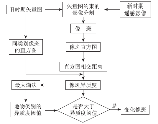
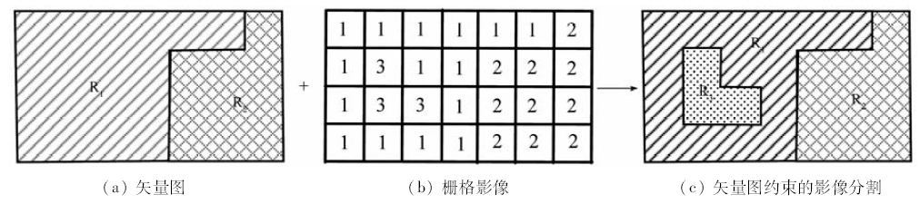
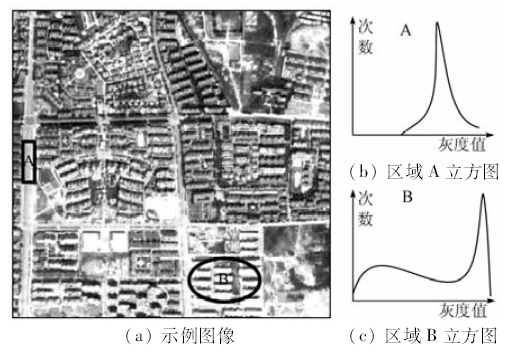
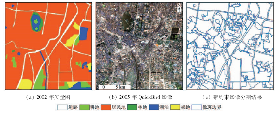
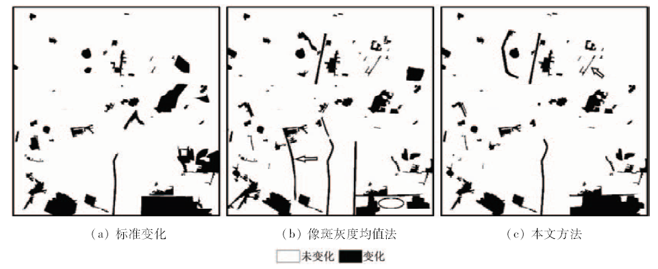
In order to realize the automatic change detection with vector map and remote sensing imagery, a change detection method based on the object heterogeneity for vector map and remote sensing imagery is proposed in the paper. Image segmentation under the constraint of vector map was employed to get image objects using marker-based watershed algorithm. The features of the object were extracted by histogram which describes both gray feature and texture feature. The histogram intersection distance was adopted to measure the feature distance. The object heterogeneity was built by the average of the distance between the object and the other objects with the same class in old period. Change/nochange label of the objects can be determined by comparison the object heterogeneity with the heterogeneity threshold of the class which was calculated by Maximum Entropy Principle automatically. Experiments on QuickBird remote sensing images verified the effectiveness of the proposed method ,and the correct rate of the change detection is up to 95%.
李亮, 王蕾, 王凯, 李胜. 基于像斑异质度的矢量图与遥感影像变化检测[J]. 国土资源遥感, 2018, 30(1): 30-36.
Liang LI, Lei WANG, Kai WANG, Sheng LI. A change detection method for vector map and remote sensing imagery based on object heterogeneity. Remote Sensing for Land & Resources, 2018, 30(1): 30-36.
Huang W,Huang J L,Wang L H,et al.Remote sensing image change detection based on change vector analysis of PCA component[J].Remote Sensing for Land and Resources,2016,28(1):22-27.doi:10.6046/gtzyyg.2016.01.04.
[2]
Xu M,Cao C X,Zhang H,et al.Change detection of an earthquake-induced barrier lake based on remote sensing image classification[J].International Journal of Remote Sensing,2010,31(13):3521-3534.
Zhao M,Chen W P,Wang H Y.Updating of topographic maps based on change detection for remote sensing image[J]. Bulletin of Surveying and Mapping, 2013(4):65-67.
[4]
Mas J F.Monitoring land-cover changes:A comparison of change detection techniques[J].International Journal of Remote Sensing,1999,20(1):139-152.
[5]
Lu D,Mausel P,Brondízio E,et al.Change detection techniques[J].International Journal of Remote Sensing,2004,25(12):2365-2401.
Li D R.Change detection from remote sensing images[J].Geomatics and Information Science of Wuhan University,2003,28(s1):7-12.
[7]
Walter V.Object-based classification of remote sensing data for change detection[J].ISPRS Journal of Photogrammetry and Remote Sensing,2004,58(3/4):225-238.
Zhang J X,Yang G J.Automatic land use and land cover change detection with one temporary remote sensing image[J].Journal of Remote Sensing,2005,9(3):294-299.
Xie R W,Niu Z,Sun R,et al.The detection of land use change based on the statistic test with multi-band image[J].Remote Sensing for Land and Resources,2009,21(2):66-70.doi:10.6046/gtzyyg.2009.02.14.
[10]
Meyer F.Color image segmentation[C]//Proceedings of the international conference on image processing and its applications.Maastricht, Netherlands:IEEE,1992:303-306.
Wu Z C,Hu Z W,Zhang Q,et al.On combining spectral, textural and shape features for remote sensing image segmentation[J].Acta Geodaetica et Cartographica Sinica,2013,42(1):44-50.
[12]
Wang A P,Wang S G,Lucieer A.Segmentation of multispectral high-resolution satellite imagery based on integrated feature distributions[J].International Journal of Remote Sensing,2010,31(6):1471-1483.
Li L,Zhang Y,Li S,et al.Classification of remote sensing images based on the fusion of spatial relationship[J].Remote Sensing for Land and Resources,2017,29(3):10-16. doi:10.6046/gtzyyg.2017.03.02.
[14]
Ojala T,Pietikäinen M.Unsupervised texture segmentation using feature distributions[J].Pattern Recognition,1999,32(3):477-486.
You H J,Fu K.SAR change detection based on cluster distribution divergence[J].Geomatics and Information Science of Wuhan University,2008,33(5):454-456.
[16]
Swain M J,Ballard D H.Color indexing[J].International Journal of Computer Vision,1991,7(1):11-32.
[17]
Chen K M,Chen S Y.Color texture segmentation using feature distributions[J].Pattern Recognition Letters,2002,23(7):755-771.
[18]
Otsu N.A threshold selection method from gray-level histograms[J].Automatica,1975,11:23-27.
[19]
Sahoo P,Wilkins C,Yeager J.Threshold selection using Renyi’s entropy[J].Pattern Recognition,1997,30(1):71-84.
Li L, Shu N, Wang K, et al.Change detection method for remote sensing images based on multi-features fusion[J]. Acta Geodaetica et Cartographica Sinica,2014,43(9):945-953.
 2018, Vol. 30
  ), 王蕾1, 王凯2, 李胜1