Please wait a minute...
 
国土资源遥感  2018, Vol. 30 Issue (1): 238-242    DOI: 10.6046/gtzyyg.2018.01.33
  本期目录 | 过刊浏览 | 高级检索 |
内存数据库在ZY1-02C海量数据空间检索中的应用
王彦佐(), 周伟, 冯磊
中国国土资源航空物探遥感中心,北京 100083
Application of main memory database to spatial query of mass ZY1-02C data
Yanzuo WANG(), Wei ZHOU, Lei FENG
China Aero Geophysical Survey and Remote Sensing Center for Land and Resources, Beijing 100083, China
全文: PDF(906 KB)   HTML  
输出: BibTeX | EndNote (RIS)      
摘要 

实现海量空间数据的高效检索是资源一号02C(ZY1-02C)卫星数据应用的重要前提。在传统基于关系型数据库的空间查询模式中,频繁的磁盘I/O及内外存交换对查询性能有较大影响,而完全基于内存的内存数据库技术可有效规避这一问题,显著提升效率。基于Key-Value型内存数据库Redis,研究并设计了矢量数据在Redis中的存储结构,并实现了基于Key-Value型存储结构的空间R树索引。经实际应用检验,该存储及索引架构能够有效提升海量空间数据的查询检索性能。

服务
把本文推荐给朋友
加入引用管理器
E-mail Alert
RSS
作者相关文章
王彦佐
周伟
冯磊
关键词 内存数据库空间索引矢量数据    
Abstract

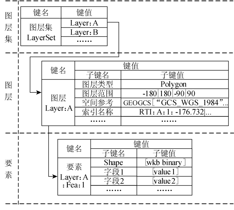
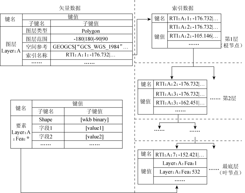
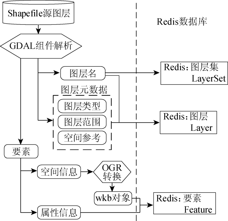
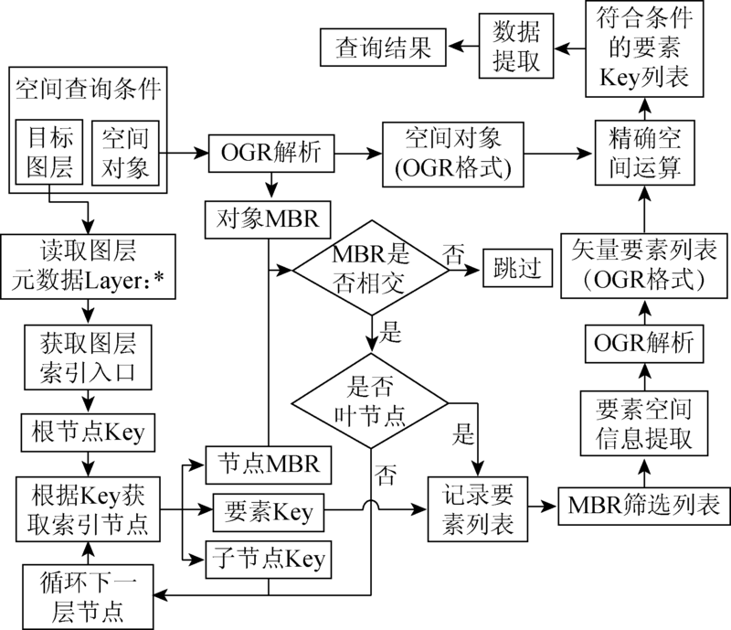
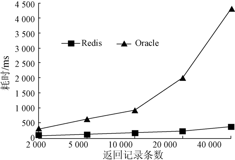
Fast spatial query is the foundation of the mass ZY1-02C data application. In the traditional spatial query structure using relational database, frequent disk I/Os and data swaps degrade the query performance a lot. In contrast, main memory database which is completely based on the memory can significantly improve the searching efficiency. In this study, a vector data storage and R-tree indexing structure was designed and implemented based on the Redis database, which is a main memory database of Key-Value type. This structure was used in practice and the efficiency of spatial query was improved.

Key wordsmain memory database    spatial index    vector data
收稿日期: 2016-06-29      出版日期: 2018-02-08
:  TP302  
基金资助:国土资源部公益性行业科研专项项目“资源一号02C星地质矿产与地质灾害环境应用模式及关键技术研究”(编号: 201311036)资助
作者简介:

第一作者: 王彦佐(1986- ),男,硕士,主要从事地理信息系统方面的研究。Email:wangyanzuo@foxmail.com

引用本文:   
王彦佐, 周伟, 冯磊. 内存数据库在ZY1-02C海量数据空间检索中的应用[J]. 国土资源遥感, 2018, 30(1): 238-242.
Yanzuo WANG, Wei ZHOU, Lei FENG. Application of main memory database to spatial query of mass ZY1-02C data. Remote Sensing for Land & Resources, 2018, 30(1): 238-242.
链接本文:  
https://www.gtzyyg.com/CN/10.6046/gtzyyg.2018.01.33      或      https://www.gtzyyg.com/CN/Y2018/V30/I1/238
Fig.1  存储结构示例
Fig.2  R树存储结构示例
Fig.3  矢量数据转换入库流程
Fig.4  空间数据检索流程
Fig.5  空间数据检索效率测试
[1] 薛涛,刁明光,李建存,等.资源环境遥感海量空间数据存储、检索和访问方法[J].国土资源遥感,2013,25(2):168-173.doi:10.6046/gtzyyg.2013.02.28.
Xue T,Diao M G,Li J C,et al.Approach to storing, retrieving and accessing mass spatial data in resources and environments remote sensing[J].Remote Sensing for Land and Resources,2013,25(2):168-173.doi:10.6046/gtzyyg.2013.02.28.
[2] 杨武军,张继荣,屈军锁.内存数据库技术综述[J].西安邮电学院学报,2005,10(3):95-99.
Yang W J,Zhang J R,Qu J S.An overview of main-memory database technologies[J].Journal of Xi’an University of Post and Telecommunications,2005,10(3):95-99.
[3] 王珊,肖艳芹,刘大为,等.内存数据库关键技术研究[J].计算机应用,2007,27(10):2353-2357.
Wang S,Xiao Y Q,Liu D W,et al.Research of main memory database[J].Computer Applications,2007,27(10):2353-2357.
[4] Wikipedia.Key-value database[EB/OL].(2016-05-16)[2016-06-27].
[5] Redislabs.Redis[EB/OL].(2016-06-17)[2016-06-27]..
[6] 朱进,胡斌,邵华,等.基于内存数据库Redis的轻量级矢量地理数据组织[J].地理信息科学,2014,16(2):165-172.
Zhu J,Hu B,Shao H,et al.Research of lightweight vector geographic data management based on main memory database Redis[J].Journal of Geo-information Science,2014,16(2):165-172.
[7] 阎超德,赵学胜.GIS空间索引方法述评[J].地理与地理信息科学,2004,20(4):23-26,39.
Yan C D,Zhao X S.The review of spatial indexes in GIS[J].Geography and Geo-Information Science,2004,20(4):23-26,39.
[8] 史文中,郭薇,彭奕彰.一种面向地理信息系统的空间索引方法[J].测绘学报,2001,30(2):156-161.
Shi W Z,Guo W,Peng Y Z.A spatial indexing method for GIS[J].Acta Geodaetica et Cartographica Sinica,2001,30(2):156-161.
[9] 黄晓明,杨红雨,闫觅.基于R树的空管GIS数据模型索引的设计[J].微计算机信息,2008,24(8-3):144-146.
Huang X M,Yang H Y,Yan M.The index design for ATC GIS data model based on R tree[J].Microcomputer Information,2008,24(8-3):144-146.
[10] 罗琪,李军,陈荦.基于GIS平台的R树索引模型研究与实现[J].计算机工程与科学,2003,25(6):93-96.
Luo Q,Li J,Chen L.Research and implementation of a R-tree index model based on the GIS platform[J].Computer Engineering and Science,2003,25(6):93-96.
[1] 李亮, 应国伟, 文学虎, 何鑫. 融合时间特征的高分辨率遥感影像分类[J]. 国土资源遥感, 2016, 28(2): 91-98.
[2] 刘理想, 唐远彬, 刘仁义, 张丰, 刘南. 基于夹角判断的复杂多边形边界排序算法[J]. 国土资源遥感, 2011, 23(2): 15-18.
[3] 刘祥磊, 马静. 基于ArcEngine的ArcGIS矢量数据到KML文件转换方法研究[J]. 国土资源遥感, 2007, 19(3): 98-101.
[4] 本刊. ERDAS IMAGINE遥感图像处理系统的特点[J]. 国土资源遥感, 2002, 14(3): 78-79.
[5] 富融科技有限公司. ERDAS(IMAGINE)——遥感领域专业分析软件的排头兵[J]. 国土资源遥感, 2002, 14(2): 69-69.
[6] 富融科技有限公司. ERDAS(IMAGINE)——遥感领域专业分析软件的排头兵[J]. 国土资源遥感, 2002, 14(1): 69-69.
Viewed
Full text


Abstract

Cited

  Shared   
  Discussed   
京ICP备05055290号-2
版权所有 © 2015 《自然资源遥感》编辑部
地址:北京学院路31号中国国土资源航空物探遥感中心 邮编:100083
电话:010-62060291/62060292 E-mail:zrzyyg@163.com
本系统由北京玛格泰克科技发展有限公司设计开发