Please wait a minute...
 
国土资源遥感  2018, Vol. 30 Issue (3): 48-54    DOI: 10.6046/gtzyyg.2018.03.07
     本期目录 | 过刊浏览 | 高级检索 |
基于人工蜂群算法的多角度遥感影像分类
杨雪峰, 叶茂(), 毛东雷
新疆师范大学地理科学与旅游学院,乌鲁木齐 830054
Multi-angle remote sensing image classification based on artificial bee colony algorithm
Xuefeng YANG, Mao YE(), Donglei MAO
College of Geography Science and Tourism, Xinjiang Normal University, Urumqi 830054, China
全文: PDF(1216 KB)   HTML  
输出: BibTeX | EndNote (RIS)      
摘要 

人工蜂群(artificial bee colony,ABC)算法在最优化领域有广泛的应用,但在遥感影像分类应用中研究较少。通过使用ABC算法构建基于规则的分类系统,对塔里木河中下游多角度遥感观测数据构建的多维数据集进行分类,生成决策规则集; 并与最大似然分类法(maximum likelihood classification,MLC)、C4.5决策树法和支持向量机(support vector machine,SVM)分类结果进行比较。结果表明,ABC算法总体分类精度高于MLC和C4.5,但低于SVM。通过对规则中分类属性的频数分析,证明使用ABC算法可有效发现多角度数据观测结果与不同土地覆被类型之间的关系。

服务
把本文推荐给朋友
加入引用管理器
E-mail Alert
RSS
作者相关文章
杨雪峰
叶茂
毛东雷
关键词 人工蜂群(ABC)算法多角度遥感土地覆被塔里木河中下游    
Abstract

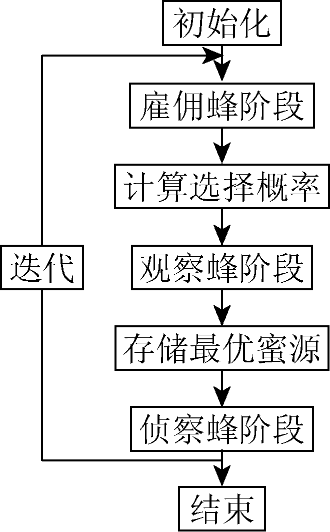
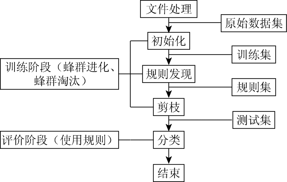
Artificial bee colony(ABC)algorithm is widely used in optimization field, but the study of the applications of the remote sensing image classification is inadequate. Through the use of ABC algorithm,the classification system was constructed on the basis of rules. The multi-dimensional data sets consisting of the multi-angle remote sensing observation data originating from the middle and lower reaches of Tarim River were investigated so as to generate the decision rules. A comparison with the classification results of the maximum likelihood method(MLC), C4.5 decision tree and support vector machine(SVM) shows that classification accuracy of ABC is higher than that of MLC and C4.5 overall, but lower than that of SVM. At the same time, through the frequency analysis of the classification attributes in the rules, it is proved that ABC can effectively discover the relationship between the results of the multi-angle data observation and different land cover types.

Key wordsartificial bee colony(ABC)algorithm    multi-angle remote sensing    land cover    middle and lower reaches of Tarim River
收稿日期: 2016-12-29      出版日期: 2018-09-10
:  TP79  
基金资助:国家自然科学基金项目“塔里木河胡杨径向生长与水分关系研究”(41461045)
通讯作者: 叶茂
作者简介: 杨雪峰(1972-),男,硕士,讲师,主要从事干旱区资源环境遥感技术应用研究。Email: geomanyxf@sina.com。
引用本文:   
杨雪峰, 叶茂, 毛东雷. 基于人工蜂群算法的多角度遥感影像分类[J]. 国土资源遥感, 2018, 30(3): 48-54.
Xuefeng YANG, Mao YE, Donglei MAO. Multi-angle remote sensing image classification based on artificial bee colony algorithm. Remote Sensing for Land & Resources, 2018, 30(3): 48-54.
链接本文:  
https://www.gtzyyg.com/CN/10.6046/gtzyyg.2018.03.07      或      https://www.gtzyyg.com/CN/Y2018/V30/I3/48
Fig.1  ABC算法流程
Fig.2  基于ABC算法的数据分类流程
波段 MISR各角度影像波段空间分辨率
DF CF BF AF AN AA BA CA DA
近红外 1 100 1 100 1 100 1 100 275 1 100 1 100 1 100 1 100
红光 275 275 275 275 275 275 275 275 275
蓝光 1 100 1 100 1 100 1 100 275 1 100 1 100 1 100 1 100
绿光 1 100 1 100 1 100 1 100 275 1 100 1 100 1 100 1 100
Tab.1  全球模式下MISR各角度影像波段空间分辨率
类型 样地数 覆盖度/% 描述
灌木 1 888 >5 灌木、半灌木
林地 1 148 >5 胡杨林
水体 95 0 水库、天然水体
未利用地 647 <5 沙地、盐碱地
耕地 383 >40 农田
草地 206 >5 盐生草本植物
Tab.2  土地覆被类型
类型 灌木 林地 水体 未利
用地
耕地 草地 总数 用户
精度
灌木 337 138 0 102 6 40 623 0.54
林地 62 266 0 34 1 15 378 0.70
水体 0 0 34 0 0 1 35 0.97
未利用地 22 4 0 187 0 4 217 0.86
耕地 1 0 0 0 130 0 131 0.99
草地 7 5 0 6 0 40 58 0.69
总数 429 413 34 329 137 100 1 442
生产者
精度
0.79 0.64 1.00 0.57 0.95 0.40
Tab.3  MLC法分类结果混淆矩阵
类型 灌木 林地 水体 未利
用地
耕地 草地 总数 用户
精度
灌木 466 101 0 44 1 11 623 0.75
林地 155 203 0 16 0 4 378 0.54
水体 1 0 34 0 0 0 35 0.97
未利用地 52 12 0 151 0 2 217 0.70
耕地 2 0 0 0 126 3 131 0.96
草地 17 5 0 4 1 31 58 0.53
总数 693 321 34 215 128 51 1 442
生产者
精度
0.67 0.63 1.00 0.70 0.98 0.61
Tab.4  C4.5法分类结果混淆矩阵
类型 灌木 林地 水体 未利
用地
耕地 草地 总数 用户
精度
灌木 490 93 0 32 0 8 623 0.79
林地 150 210 0 16 0 2 378 0.56
水体 2 0 33 0 0 0 35 0.94
未利用地 65 9 0 143 0 0 217 0.66
耕地 2 0 0 0 127 2 131 0.97
草地 30 1 0 1 0 26 58 0.45
总数 739 313 33 192 127 38 1 442
生产者
精度
0.66 0.67 1.00 0.74 1.00 0.68
Tab.5  ABC算法分类结果混淆矩阵
类型 灌木 林地 水体 未利
用地
耕地 草地 总数 用户
精度
灌木 498 96 0 22 1 6 623 0.80
林地 104 259 0 9 0 6 378 0.69
水体 0 0 27 0 8 0 35 0.77
未利用地 46 12 0 157 1 1 217 0.72
耕地 1 0 0 1 129 0 131 0.98
草地 10 5 0 1 0 42 58 0.72
总数 659 372 27 190 139 55 1 442
生产者
精度
0.76 0.70 1.00 0.83 0.93 0.76
Tab.6  SVM分类结果混淆矩阵
Fig.3  ABC算法规则属性频数分布曲线
[1] Paul M, Brandt T. Classification Methods for Remotely Sensed Data[M].2nd ed. Boca Raton: CRC Press, 2009.
[2] Al-doski J, Mansor S B, Shafri H Z M . Image classification in remote sensing[J]. Journal of Environment and Earth Science, 2013,3(10):141-148.
[3] 贾坤, 李强子, 田亦陈 , 等. 遥感影像分类方法研究进展[J]. 光谱学与光谱分析, 2011,31(10):2618-2623.
Jia K, Li Q Z, Tian Y C , et al. A review of classification methods of remote sensing imagery[J]. Spectroscopy and Spectral Analysis, 2011,31(10):2618-2623.
[4] Abburu S, Babu G S . Satellite image classification methods and techniques:A review[J]. International Journal of Computer Applications, 2015,119(8):20-25.
doi: 10.5120/21088-3779
[5] 白秀莲, 巴雅尔 , 哈斯其其格.基于C5.0的遥感影像决策树分类实验研究[J]. 遥感技术与应用, 2014,29(2):338-343.
doi: 10.11873j.issn.1004-0323.2014.2.0338
Bai X L, Wuliangha B , Hasiqiqige.The study of the remote sensing image classification based on C5.0 algorithm of decision tree[J]. Remote Sensing Technology and Application, 2014,29(2):338-343.
[6] 王小明, 毛梦祺, 张昌景 , 等. 基于支持向量机的遥感影像分类比较研究[J]. 测绘与空间地理信息, 2013,36(4):17-20,23.
Wang X M, Mao M Q, Zhang C J , et al. Comparative study on classification of remote seining image by support vector machine[J]. Geomatics and Spatial Information Technology, 2013,36(4):17-20,23.
[7] Holden N P, Freitas A A. A hybrid PSO/ACO algorithm for classification [C]//Proceedings of the 9th annual Conference Genetic and Evolutionary Computation.London:ACM, 2007: 2745-2750.
[8] Parpinelli R S, Lopes H S, Freitas A A . Data mining with an ant colony optimization algorithm[J]. IEEE Transactions on Evolutionary Computation, 2002,6(4):321-332.
doi: 10.1109/TEVC.2002.802452
[9] Tereshko V . Reaction-diffusion model of a honeybee colony’s foraging behaviour[M] //Schoenauer M,Deb K,Rudolph G,et al.Parallel Problem Solving from Nature PPSN VI Lecture Notes in Computer Science.Berlin,Heidelberg:Springer, 2000: 807-816.
[10] Karaboga D, Basturk B. Artificial bee colony (ABC) optimization algorithm for solving constrained optimization problems [C]//Proceedings of the 12th International Fuzzy Systems Association World Congress on Foundations of Fuzzy Logic and Soft Computing.Cancun,Mexico:Springer, 2007: 789-798.
[11] Çelik M, Karaboğa D,Köylü F.Artificial bee colony data miner (ABC-Miner) [C]//Proceedings of 2011 International Symposium on Innovations in Intelligent Systems and Applications.Istanbul,Turkey:IEEE, 2011: 96-100.
[12] Lichman M.UCI Machine Learning Repository[DB/OL].[ 2015- 05- 05]. .
[13] Shukran M A M, Chung Y Y, Yeh W C , et al. Artificial bee colony based data mining algorithms for classification tasks[J]. Modern Applied Science, 2011,5(4):217-231.
doi: 10.5539/mas.v5n4p217
[14] Jayanth J, Koliwad S, Kumar T A . Classification of remote sensed data using artificial bee colony algorithm[J]. Egyptian Journal of Remote Sensing and Space Science, 2015,18(1):119-126.
doi: 10.1016/j.ejrs.2015.03.001
[15] 曹敏, 史照良, 阳建逸 . 一种基于蜂群智能算法的遥感影像分类方法[J]. 测绘学报, 2013,42(5):745-751.
Cao M, Shi Z L, Yang J Y . An innovative method to classify remote sensing images using artificial bee colony algorithm[J]. Acta Geodaetica et Cartographica Sinica, 2013,42(5):745-751.
[16] 王慧颖, 刘建军, 王全洲 . 改进的人工蜂群算法在函数优化问题中的应用[J]. 计算机工程与应用, 2012,48(19):36-39.
Wang H Y, Liu J J, Wang Q Z . Modified artificial bee colony algorithm for numerical function optimization[J]. Computer Engineering and Applications, 2012,48(19):36-39.
[17] Diner D J,Martonchik J V,Borel C,et al.Multi-angle imaging spectro-radiometer level 2 surface retrieval algorithm theoretical basis document[EB/OL].( 2000- 08- 05)[2015-10-01] .
[18] 杨雪峰, 王雪梅, 毛东雷 . 塔里木河下游土地利用覆被MISR多角度遥感制图[J]. 吉林大学学报(地球科学版), 2016,46(2):617-626.
doi: 10.13278/j.cnki.jjuese.201602306
Yang X F, Wang X M, Mao D L . Mapping land use and land cover through MISR multi-angle imagery in the lower Tarim River[J]. Journal of Jilin University (Earth Science Edition), 2016,46(2):617-626.
[19] 梁禹, 刘宇 . 蜂群算法优化性能综合测试研究[J]. 计算机工程与应用, 2015,51(21):138-143.
Liang Y, Liu Y . Comprehensive test and study of artificial bee colony algorithm[J]. Computer Engineering and Applications, 2015,51(21):138-143.
[20] ENVI.Homepage[EB/OL].( 2010- 10- 01)[2015-10-01]. .
[21] Weka.Homepage[EB/OL].( 2002- 03- 28)[2015-10-01]. .
[22] Chang C C,Lin C J.LIBSVM:A library for support vector ma-chines[EB/OL].( 2001- 01- 28)[2015-10-1]. .
[1] 牟晓莉, 李贺, 黄翀, 刘庆生, 刘高焕. Google Earth Engine在土地覆被遥感信息提取中的研究进展[J]. 国土资源遥感, 2021, 33(2): 1-10.
[2] 金楷仑, 郝璐. 基于遥感数据与SEBAL模型的江浙沪地区地表蒸散反演[J]. 国土资源遥感, 2020, 32(2): 204-212.
[3] 马超, 蔡盼丽. 徂徕山—莲花山地区环境生态指数时空变化与驱动因素分析[J]. 国土资源遥感, 2019, 31(4): 199-208.
[4] 孟庆林, 李明玉, 任春颖, 王宗明, 田艳林. 基于HSI模型的吉林省东部地区生境质量动态评价[J]. 国土资源遥感, 2019, 31(3): 140-147.
[5] 宋宏利, 张晓楠. 国家尺度异源土地覆被遥感产品精度评价[J]. 国土资源遥感, 2018, 30(3): 26-32.
[6] 孙宇翼, 赵军利, 王苗苗, 刘勇. 基于J48决策树的面向对象方法的土地覆被信息提取[J]. 国土资源遥感, 2016, 28(4): 156-163.
[7] 崔林林, 罗毅, 包安明. NWFE结合纹理特征的SVM土地覆被分类方法研究[J]. 国土资源遥感, 2012, 24(1): 36-42.
[8] 李玲, 王红, 刘庆生, 宁吉才. 基于纹理特征和支持向量机的ALOS图像土地覆被分类[J]. 国土资源遥感, 2011, 23(4): 58-63.
[9] 李伟萍, 曾源, 张磊, 尹锴, 袁超, 吴炳方. 丹江口水库消落区土地覆被空间格局分析[J]. 国土资源遥感, 2011, 23(4): 108-114.
[10] 张磊, 吴炳方. 关于土地覆被遥感监测的几点思考[J]. 国土资源遥感, 2011, 23(1): 15-20.
[11] 叶宝莹, 祝艳, 季玮, 张养贞, 张树文. 基于遥感和GIS的三江平原农业景观空间格局与土地利用变化研究[J]. 国土资源遥感, 2007, 19(3): 78-81.
[12] 庄家礼, 徐希孺. 遗传算法在组分温度反演中的应用[J]. 国土资源遥感, 2000, 12(1): 28-33.
[13] 高峰. GPS引导下的多角度遥感图像自动匹配[J]. 国土资源遥感, 1997, 9(4): 47-53.
Viewed
Full text


Abstract

Cited

  Shared   
  Discussed   
京ICP备05055290号-2
版权所有 © 2015 《自然资源遥感》编辑部
地址:北京学院路31号中国国土资源航空物探遥感中心 邮编:100083
电话:010-62060291/62060292 E-mail:zrzyyg@163.com
本系统由北京玛格泰克科技发展有限公司设计开发