Comparison and analysis of estimation models of soil organic matter content established by hyperspectral on ground
Yongmin WANG1, Xican LI2, Linya TIAN1, Bin JIA3, Hui YANG4
1.School of Earth Sciences and Engineering, Hohai University, Nanjing 211100, China 2.College of Information Science and Engineering, Shandong Agricultural University, Taian 271018, China 3.CCFED the Third Construction Engineering Co., Zunyi 563000, China 4.School of Transportation, Southeast University, Nanjing 210000, China
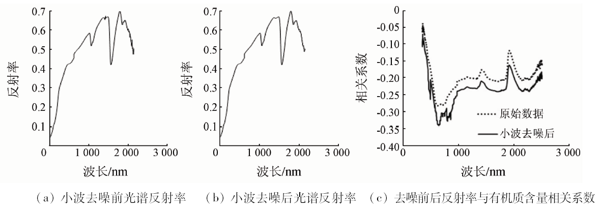
Using the data obtained by hyperspectral techniques to estimate the content of soil organic matter is a hotspot in recent years. For the purpose of determining the effective estimation modeling method, specific data such as reflectance obtained by hyperspectral on ground and organic matter content were used in this paper. Wavelet analysis was used to remove the noise, and continuum removal was used to extract the parameters and compress the data. Combining a variety of different data transformation methods and utilizing BP neural networks, multiple linear regression (MLR) and least squares regression (LSR), many different estimation models of soil were established. It is found that the neural network method is superior to the regression model among various data transformation methods after comparing different estimation models established by the three modeling methods. The optimal estimation model is the model established by the combination of logarithmic square transformation and neural network. The R2 of the model is 0.933 and the RMSE is 0.069. The authors creatively carried out the data transformation at the modeling factor level and established the good estimation model. It is shown that the learning mechanism of BP + LS model is suitable for hyperspectral estimation of soil organic matter and works well. The methods, models and conclusions of this paper have some reference significance for the hyperspectral estimation of soil organic matter.
王永敏, 李西灿, 田林亚, 贾斌, 杨惠. 土壤有机质含量地面高光谱估测模型对比分析[J]. 国土资源遥感, 2019, 31(1): 110-116.
Yongmin WANG, Xican LI, Linya TIAN, Bin JIA, Hui YANG. Comparison and analysis of estimation models of soil organic matter content established by hyperspectral on ground. Remote Sensing for Land & Resources, 2019, 31(1): 110-116.
Qiu H X, Huang Z Y, Li X C . Data transformation model analysis on spectral retrieved deduction of soil properties index[J]. Science of Surveying and Mapping, 2013,38(3):131-133.
Guo C F, Guo X Y . Estimation of wetland plant leaf chlorophyll content based on continuum removal in the visible domain[J]. Acta Ecologica Sinica, 2016,36(20):6538-6546.
[4]
Kokaly R F, Clark R N . Spectroscopic determination of leaf biochemistry using band-depth analysis of absorption features and stepwise multiple linear regression[J]. Remote Sensing of Environment, 1999,67(3):267-287.
doi: 10.1016/S0034-4257(98)00084-4
Chen Z W, Chen G S, Zhong X F , et al. Review on estimation of soil organic carbon content based on hyperspectral measurements[J]. Journal of Subtropical Resources and Environment, 2009,4(1):78-87.
Peng J, Zhang Y Z, Zhou Q , et al. The progress on the relationship physics-chemistry properties with spectrum characteristic of the soil[J]. Chinese Journal of Soil Science, 2009,40(5):1204-1208.
Liao Q H, Gu X H, Li C J , et al. Estimation of fluvo-aquic soil organic matter content from hyperspectral reflectance based on continuous wavelet transformation[J]. Transactions of the Chinese Society of Agricultural Engineering, 2012,28(23):132-139.
[8]
Liu H J, Zhang Y Z, Zhang B , et al. Novel hyperspectral reflectance models for estimating black-soil organic matter in Northeast China[J]. Environmental Monitoring and Assessment, 2009,154(1-4):147-154.
doi: 10.1007/s10661-008-0385-4
pmid: 18560985
[9]
Karnieli A, Verchovsky I, Hall J K , et al. Geographic information system for semi-detailed mapping of soils in semi-arid region[J]. Geocarto International, 1998,13(3):29-42.
doi: 10.1080/10106049809354650
Shen R P, Ding G X, Wei G S , et al. Retrieval of soil organic matter content from hyper-spectrum based on ANN[J]. Acta Pedologica Sinica, 2009,46(3):391-397.
Yu L, Hong Y S, Zhou Y , et al. Inversion of soil organic matter content using hyperspectral data based on continuous wavelet transformation[J]. Spectroscopy and Spectral Analysis, 2016,36(5):1428-1433.
Peng X T, Gao W X, Wang J J . Inversion of soil parameters from hyperspectra based on continuum removal and partial least squares regression[J]. Geomatics and Information Science of Wuhan University, 2014,39(7):862-866.
Kong L J. Super Learning Manual of Wavelet Analysis Based on MATLAB[M]. Beijing: Posts and Telecom Press, 2014: 100-160.
[14]
Ben-Dor E, Banin A . Visible and near infrared(0.4 -1.1 μm) analysis of arid and semiarid soil[J]. Remote Sensing of Environment, 1994,48(3):261-274.
doi: 10.1016/0034-4257(94)90001-9
Li X C, Wang J, Li Y H , et al. High spectral retrieved deduction of soil quality index based on fuzzy sets analysis[J]. Geography and Geo-Information Science, 2008,24(4):25-28.
Shen S Z, Zhang X L, Heng W . Improved Harris corner detection algorithm based on auto-adaptive threshold and pre-selection[J]. Journal of Data Acquisition and Processing, 2011,26(2):207-213.
Deng X L, Wang C Y, Kang Q , et al. An adaptive matching algorithm for ground control point of remote sensing image based on corner extraction[J]. Journal of Astronautics, 2006,27(1):45-50,88.
He T, Wang J, Lin Z J , et al. Spectral features of soil organic matter[J]. Geomatics and Information Science of Wuhan University, 2006,31(11):975-979.
Guo D D, Huang S M, Zhang S Q , et al. Comparative analysis of various hyperspectral prediction models of fluvo-aquicsoil organic matter[J]. Transactions of the Chinese Society of Agricultural Engineering, 2014,30(21):192-200.
 2019, Vol. 31