Please wait a minute...
 
国土资源遥感  2019, Vol. 31 Issue (1): 264-270    DOI: 10.6046/gtzyyg.2019.01.34
  地理信息系统 本期目录 | 过刊浏览 | 高级检索 |
实景模型在传统村落数字博物馆中的应用
李佳俊, 徐辉, 赵大伟
中国城市规划设计研究院学术信息中心,北京 100044
The application of real scene model to digital museum of traditional villages
Jiajun LI, Hui XU, Dawei ZHAO
Academic Information Center, China Academy of Urban Planning & Design, Beijing 100044, China
全文: PDF(4288 KB)   HTML  
输出: BibTeX | EndNote (RIS)      
摘要 

利用三维实景建模进行传统村落数字化具有效率高、还原度真实的优势。以安徽省黄山市13个村落为研究区开展模型重建试验,首先,采用多旋翼飞行器挂载五镜头倾斜相机完成对村落影像数据的采集和预处理; 然后,结合ContextCapture软件进行空三解算和重建模型; 最后,得到村落模型成果并将该模型窗口在中国传统村落数字博物馆的网页中调用。结果表明,该方法适用于村落范围的模型构建,能够自动生产出空间分辨率高、拓扑关系良好、细节表现丰富的实景模型,对于中国传统村落数字博物馆的建设起到了积极作用; 同时通过分析多个村落的数据处理时间,得到了空三解算时间与数据采集时间的内在关系,并给出了在地貌环境复杂的传统村落环境下实施飞行任务的若干建议。

服务
把本文推荐给朋友
加入引用管理器
E-mail Alert
RSS
作者相关文章
李佳俊
徐辉
赵大伟
关键词 三维实景模型传统村落ContextCapture航线规划重建模型    
Abstract

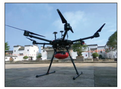
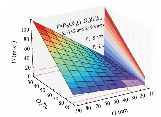
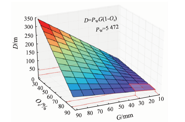
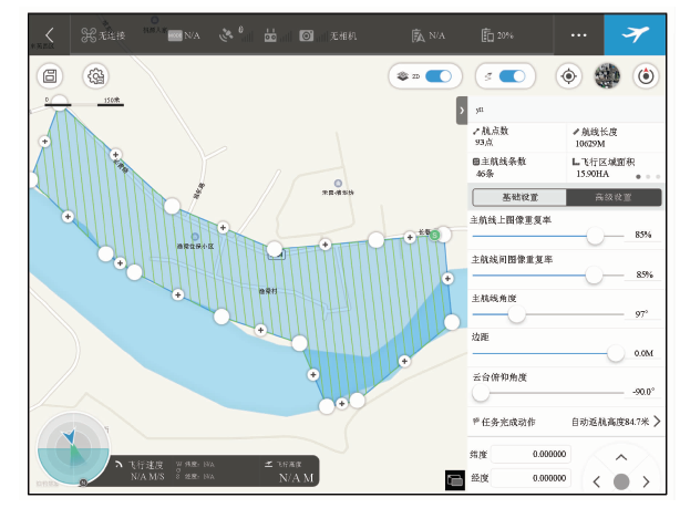
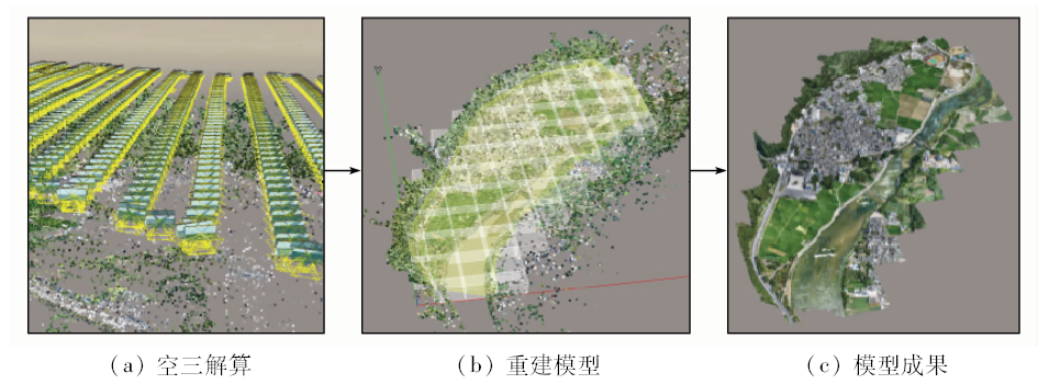
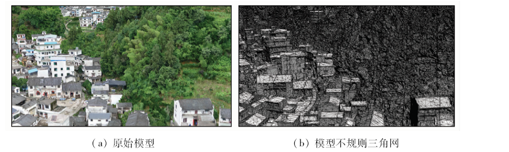
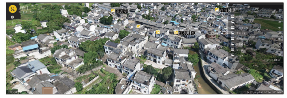
Using three-dimensional landscape modeling to do traditional village digitization has the advantages of high efficiency and reduction degree. By launching the reconstruction of 13 villages in southern Anhui, with multi-rotor aircraft which carries five cameras to complete the villages’ image data acquisition and preprocessing and, in combination with ContextCapture software to complete aerial triangulation and reconstruction, the model of village model is finally acquired and the model window is transferred and used in the website of the digital museum of the traditional village of China. The results show that this method can be applied to village of model building, and automatically produce dioramas with high resolution, good topological relations and rich details, thus playing an important role in the construction of digital museum of Chinese traditional village. Through the analysis of the data processing time of multiple villages, the authors have obtained the intrinsic relationship between aerial triangulation calculating time and data acquisition time, and give some suggestions on the implementation of the aerial task under the context of traditional villages.

Key words3D scene model    traditional villages    ContextCapture    route planning    model reconstruction
收稿日期: 2017-11-02      出版日期: 2019-03-14
:  TP79P231  
基金资助:住房和城乡建设部研究项目"完善传统村落保护管理信息系统"(建村[2017]100号)
作者简介: 李佳俊(1990-),男,硕士,助理工程师,研究方向为车载、机载、船载移动测量系统集成和应用。Email: 1162077712@qq.com。
引用本文:   
李佳俊, 徐辉, 赵大伟. 实景模型在传统村落数字博物馆中的应用[J]. 国土资源遥感, 2019, 31(1): 264-270.
Jiajun LI, Hui XU, Dawei ZHAO. The application of real scene model to digital museum of traditional villages. Remote Sensing for Land & Resources, 2019, 31(1): 264-270.
链接本文:  
https://www.gtzyyg.com/CN/10.6046/gtzyyg.2019.01.34      或      https://www.gtzyyg.com/CN/Y2019/V31/I1/264
Fig.1  数据采集系统硬件部分
飞行器参数 传感器参数 航线参数
飞行高度(H)/m 传感器宽度(Sw)/mm 航向重叠率(Oh)/%
飞行速度(V)/
(m·s-1)
传感器高度(Sh) /mm 旁向重叠率(Os)/%
飞行时间(T)/s 长边像素数(Pw)/像素 曝光间距(Ds)/m
短边像素数(Ph)/像素 航带间距(D)/m
焦距(f)/mm 地面分辨率(G)/m
曝光时间间隔(Ts)/s 航线角度(A)/(°)
Tab.1  参数列表
Fig.2  飞行速度关系
Fig.3  航带间距关系
Fig.4  渔梁村部分航线规划
连接点数量/个 反投影中
误差/像素
反投影标
准差/像素
地面点到摄站点
距离标准差/m
220 409 0.61 0.79 0.021
Tab.2  龙川村空三解算结果报告
Fig.5  数据采集时间占空三解算时间的比例
Fig.6  重建模型流程(龙川村)
Fig.7  模型面积与数据量关系
Fig.8  瀹坑村原始模型与其不规则三角网的对比
Fig.9  唐模村数字博物馆三维实景模型窗口
[1] 王桂娟, 徐铁权 . 美丽乡村建设中的传统村落文化保护[J]. 河南农业, 2017,23(8):58-60.
Wang G J, Xu T Q . The protection of traditional villages in the construction of beautiful countryside[J]. Agriculture of Henan, 2017,28(8):58-60.
[2] 陈继腾 . 传统村落保护发展应关注的问题和建议——以黄山市传统村落为例[J]. 安徽建筑, 2015,22(4):14-15.
doi: 10.16330/j.cnki.1007-7359.2015.04.002
Chen J T . Issues and suggestions needing attention in protection and development of traditional village[J]. Anhui Architecture, 2015,22(4):14-15.
[3] 王军, 夏健 . 传统村落保护的动态监控体系建构研究[J]. 城市发展研究, 2016,23(7):58-63.
Wang J, Xia J . Research on the construction of dynamic monitoring system of the protection of traditional village[J]. Urban Development Studies, 2016,23(7):58-63.
[4] 张福友 . 基于大疆无人机的Context Capture三维实景建模探讨[J]. 广东水利水电, 2017,46(8):88-91.
Zhan F Y . Real 3D modeling with Context Capture base on DJI UAV[J]. Guangdong Water Resources and Hydropower, 2017,46(8):88-91.
[5] 李伟哲 . 基于ContextCapture实景建模及应用[J]. 西北水电, 2018(3):27-31.
Li W Z . Scenic modeling and application based on ContextCapture[J]. Northwest Hydropower, 2018(3):27-31.
[6] 赵明 . Pix4D mapper软件在无人机航空摄影与工程地质调查中的数据处理[J]. 水电站设计, 2017,33(2):47-48,62.
Zhao M . Data processing of Pix4D mapper in UAV aerial photography and engineering geological survey[J]. Design of Hydroelectric Power Station, 2017,33(2):47-48,62.
[7] 李亚星 . Smart 3D在风景园林测绘中的应用[J]. 现代园艺, 2017,40(2):126.
Li Y X . Application of smart 3D in landscape architecture surveying[J]. Xiandai Horticulture, 2017,40(2):126.
[8] 刘尚蔚, 王维洋, 魏群 . 三维实景建模技术及其应用[J]. 中国水运, 2016,16(11):132-134.
Liu S W, Wang W Y, Wei Q . Real three-dimensional modeling and application[J]. China Water Transport, 2016,16(11):132-134.
No related articles found!
Viewed
Full text


Abstract

Cited

  Shared   
  Discussed   
京ICP备05055290号-2
版权所有 © 2015 《自然资源遥感》编辑部
地址:北京学院路31号中国国土资源航空物探遥感中心 邮编:100083
电话:010-62060291/62060292 E-mail:zrzyyg@163.com
本系统由北京玛格泰克科技发展有限公司设计开发