Please wait a minute...
 
国土资源遥感  2020, Vol. 32 Issue (2): 154-161    DOI: 10.6046/gtzyyg.2020.02.20
  技术应用 本期目录 | 过刊浏览 | 高级检索 |
广西自然资源调查监测体系构建
黄景金, 唐长增(), 李毅, 左天惠, 杨郑贝
广西壮族自治区自然资源调查监测院,南宁 530023
System construction for survey and monitoring of natural resources in Guangxi
Jingjin HUANG, Changzeng TANG(), Yi LI, Tianhui ZUO, Zhengbei YANG
Guangxi Insititute of Natural Resources Survey and Monitoring,Nanning 530023,China
全文: PDF(2182 KB)   HTML  
输出: BibTeX | EndNote (RIS)      
摘要 

此前,我国自然资源实行分头管理,各要素的调查监测分别由国土、水利、农业、林业、海洋等部门组织开展,这导致了各类要素调查监测存在数出多门、标准不一、成果矛盾和难以共享等问题。为解决上述问题,需要对广西自然资源全要素进行统一调查监测。广西自然资源调查监测体系的构建,将为自然资源不动产登记、国土空间规划和用途管制、生态环境保护与修复等提供准确、可靠、科学和权威的自然资源基础数据。首先,从调查监测理论体系研究入手,研究符合广西区情的调查监测方案,并强化应急监测的作用; 再重点研究了调查监测的云平台架构,分别从多维立体观测网络的搭建、遥感大数据的云计算、数据成果的分发服务等方面进行讨论; 然后,分析了体系构建中涉及的主要关键技术; 最后对基于调查监测成果的应用前景进行了展望。

服务
把本文推荐给朋友
加入引用管理器
E-mail Alert
RSS
作者相关文章
黄景金
唐长增
李毅
左天惠
杨郑贝
关键词 自然资源调查监测体系构建广西    
Abstract

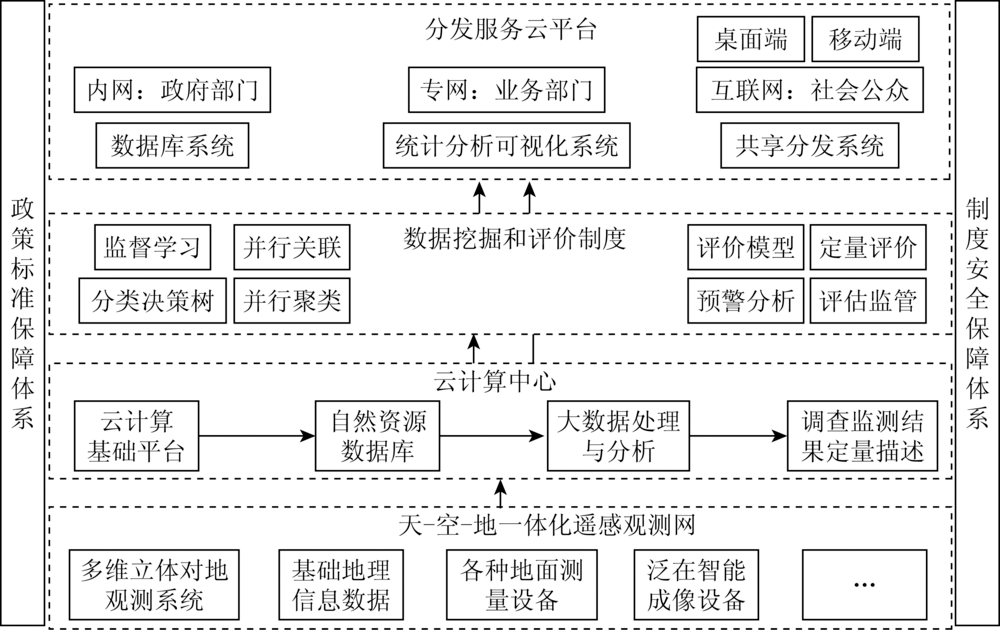
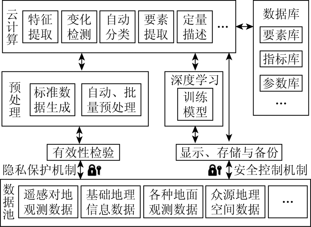
In the past, different historical periods had different important missions and, as aresult, the work of surveying and monitoring of natural resources elements of Guangxi was organized by different administrative departments. In the past, the China's natural resources were managed separately. the survey and monitoring of each element are organized and managed separately by land resources department, water resources department, agriculture department, forestry,department and marine department, etc. This led to the existence of many problems, such as multiple sources, different criteria, contradictory results and difficult share. For the purpose of solving these problems, all elements of natural resources in Guangxi need to be surveyed and monitored uniformly. The construction of a system for surveying and monitoring can provide an accurate, reliable, scientific and authoritative basic data for the registration of realestate of natural resources, the land space planning and use control, and the protection and remediation of ecological environment, etc. Starting with the theory system, the authors found the approach suitable for the situations in Guangxi and highlighted the effect of emergency monitoring. Then the architecture of cloud platform was studied and discussed, which included the multidimensional-stereoscopic observation network, the cloud computing of remote sensing big data, and the shared service of the data and results. Meanwhile, the key technologies of the system construction were analyzed. Finally, the prospect of survey and monitoring results-based applications was predicted.

Key wordsnatural resources    survey and monitoring    system construction    Guangxi
收稿日期: 2019-05-17      出版日期: 2020-06-18
:  TP79  
基金资助:第四批广西院士工作站“广西自然资源监测与地理信息应用技术研究院士工作站”(桂科成字[2018]121号);国家自然科学基金项目“基于深度卷积神经网络和超像素CRF模型的高空间分辨率遥感图像多尺度征提取与分类识别研究”(41601365);中国地震局星火计划攻关项目“面向地震应急的空间智能决策方法研究”(XH15019)
通讯作者: 唐长增
作者简介: 黄景金(1988-),男,博士,主要研究方向为自然资源调查监测和星上遥感图像实时处理。Email: jingjin_huang@tju.edu.cn。
引用本文:   
黄景金, 唐长增, 李毅, 左天惠, 杨郑贝. 广西自然资源调查监测体系构建[J]. 国土资源遥感, 2020, 32(2): 154-161.
Jingjin HUANG, Changzeng TANG, Yi LI, Tianhui ZUO, Zhengbei YANG. System construction for survey and monitoring of natural resources in Guangxi. Remote Sensing for Land & Resources, 2020, 32(2): 154-161.
链接本文:  
https://www.gtzyyg.com/CN/10.6046/gtzyyg.2020.02.20      或      https://www.gtzyyg.com/CN/Y2020/V32/I2/154
序号 调查类型 调查周期/a 调查内容
1 基础调查 10 各类自然资源在广西陆海全域空间的水平分布调查,对山水林田湖草海矿等自然资源要素进行统一调查,解决标准不一和空间重叠问题
2 专项调查 5 各类自然资源要素质量和生态状况调查、地理国情调查等,特别是广西作为生态和农业优势省区,海洋资源和有色矿产资源富集区,要更加注重对这些要素的专项调查,如: 土地利用现状、基本农田、主要经济作物、人工林、水资源、红树林、石漠化、海岸线、有色矿山开发状况和矿山环境恢复治理等情况
3 变更调查 1 广西作为沿边沿海后发展西部地区,又是林业农业大省区,自然资源多样性丰富,各类资源在水平分布、质量、生态状况方面存在各种变化,后期要更加注重变更调查工作开展,以保证调查结果的现势性
Tab.1  “1+X”型调查体系
序号 监测类型 监测周期 应用场景 数据来源
1 宏观监测 1 a 针对广西多雨多云多山情况,需要综合利用多种天基和空基观测网监测自然资源在宏观上的变化,如: 对基本农田、石漠化治理修复、三区三线、自然保护区的监测 系列遥感卫星(光学卫星、SAR卫星、视频卫星)+有人机+GNSS
2 常规监测 1~3月 针对广西林业、农业、矿产资源丰富情况,通过合理调整和增加监测内容与指标,及时掌握主要自然资源要素的时-空变化,如: 用途管制、自然资源执法监督、尾矿库的监测[12] 系列遥感卫星(光学卫星、SAR卫星、视频卫星)+有人机+中/短航时无人机+GNSS
3 精细监测 1周~1月 针对特定地区、重点工程和重点自然资源要素变化,如: 对重点产业园、高标准农田、违法建设和违法用地的监测 中/短航时无人机+移动智能终端+GNSS
4 应急监测 随时 针对突发自然灾害和特殊重点自然资源要素变化,如: 对洪水淹没地区、山体滑坡、地面塌陷的监测 有人机+中/短航时无人机+移动智能终端+GNSS
Tab.2  监测体系
Fig.1  云平台架构
Fig.2  天-空-地一体化遥感观测网
Fig.3  遥感大数据的云计算处理流程
[1] 黄贤金, 杨达源. 山水林田湖生命共同体与自然资源用途管制路径创新[J]. 上海国土资源, 2016,37(3):1-4.
Huang X J, Yang D Y. Orderly ecological system for mountains,rivers,forest,farmland and lakes,and innovation path of purpose regulation of natural resources[J]. Shanghai Land and Resources, 2016,37(3):1-4.
[2] 奋力开创自然资源调查监测新局面——访谈自然资源调查监测司司长白贵霞[J].国土资源, 2018(11):6-8.
Strive to create a new situation of investigation and monitoring in natural resources-interview Bai GuiXia-the director of investigation and monitoring in natural resources[J].Land and Resources, 2018(11):6-8.
[3] 深化党和国家机构改革方案(摘要)[EB/OL].(2018-3-29)[2019-3-27]. http://www.mnr.gov.cn/jg/jggg/201806/t20180620_1798741.html.
Deepening reform scheme of party and government institutions(Abstract)[EB/OL].(2018-3-29)[2019-3-27]. http://www.mnr.gov.cn/jg/jggg/201806/t20180620_1798741.html.
[4] 一图详解:《广西壮族自治区机构改革方案》[EB/OL].(2018-10-26)[2019-3-29] http://www.gxzf.gov.cn/tj/20181026-718976.shtml.
A figure:《Reform scheme of institutions of Guangxi Zhuang Autonomous Region》[EB/OL].(2018-10-26)[2019-3-29]. http://www.gxzf.gov.cn/tj/20181026-718976.shtml.
[5] 汪洋.在广西壮族自治区成立60周年大会上的讲话[EB/OL].( 2018- 12- 11)[2019-3-29] http://news.cctv.com/2018/12/11/ARTIp0IMtXVk0aiX2J7Liv4A181211.shtml?spm=C94212.PrwsCuCg3jyS.S52214.3
Wang Y.A speech on the 60th anniversary of the founding of Guangxi zhuang autonomous region[EB/OL].( 2018- 12- 11)[2019-3-27]. http://news.cctv.com/2018/12/11/ARTIp0IMtXVk0aiX2J7Liv4A181211.shtml?spm=C94212.PrwsCuCg3jyS.S52214.3.
[6] 我国将构建自然资源统一调查监测体系[EB/OL].(2018-8-2)[2019-3-27]. http://www.gov.cn/xinwen/2018-08/02/content_5311319.htm.
China will construct a system of the unified survey and monitoring of natural resources[EB/OL].(2018-8-2)[2019-3-27]. http://www.gov.cn/xinwen/2018-08/02/content_5311319.htm.
[7] 2019年广西自然资源工作会议在南宁召开[EB/OL]. http://www.mnr.gov.cn/dt/dfdt/201903/t20190329_2403370.html.
The 2019 working meeting of Guangxi natural resources was held in Nanning city[EB/OL].(2019-3-29)[2019-3-29]. http://www.mnr.gov.cn/dt/dfdt/201903/t20190329_2403370.html.
[8] 广西概况[EB/OL].(2017-12-1)[2019-7-30]. http://www.gxdqw.com/flbg/#floor_gxgk.
Guangxi situation[EB/OL].(2017-12-1)[2019-7-30]. http://www.gxdqw.com/flbg/#floor_gxgk.
[9] 陈玲, 贾佳, 王海庆. 高分遥感在自然资源调查中的应用综述[J]. 国土资源遥感, 2019,31(1):1-7.doi: 10.6046/gtzyyg.2019.01.01.
Chen L, Jia J, Wang H Q. An overview of applying high resolution remote sensing to natural resources survey[J]. Remote Sensing for Land and Resources, 2019,31(1):1-7.doi: 10.6046/gtzyyg.2019.01.01.
[10] 杨如军, 谢国雪. 国产卫星数据在国土资源监管中的探讨——以广西壮族自治区为例[J]. 国土资源遥感, 2017,29(s1):52-57.
Yang R J, Xie G X. A discussion on domestic satellite data in land and resources supervision:Taking Guangxi Zhuang Autonomous Region as example[J]. Remote Sensing for Land and Resources, 2017,29(s1):52-57.
[11] 丁宇雪. 基于国产卫星数据自然资源调查研究——以黑龙江省中西部地区为例[J]. 国土资源遥感, 2017,29(s1):121-126.doi: 10.6046/gtzyyg.2017.s1.20.
Ding Y X. Research on natural resources based on domestic satellite data:Exemplified by midwest Heilongjiang Province[J]. Remote Sensing for Land and Resources, 2017,29(s1):121-126.doi: 10.6046/gtzyyg.2017.s1.20.
[12] 王立娟, 靳晓, 贾虎军, 等. 基于国产高分卫星数据的矿山环境变化检测[J]. 国土资源遥感, 2018,30(3):151-158.doi: 10.6046/gtzyyg.2018.03.21.
Wang L J, Jin X, Jia H J, et al. Change detection for mine environment based on domestic high-resolution satellite images[J]. Remote Sensing for Land and Resources, 2018,30(3):151-158.doi: 10.6046/gtzyyg.2018.03.21.
[13] 李德仁, 张良培, 夏桂松. 遥感大数据自动分析与数据挖掘[J]. 测绘学报, 2014,43(12):1211-1216.
Li D R, Zhang L P, Xia G S. Automatic analysis and mining of remote sensing big data[J]. Acta Geodaetica et Cartographica Sinica, 2014,43(12):1211-1216.
[14] 张兵. 遥感大数据时代与智能信息提取[J]. 武汉大学学报(信息科学版), 2018,43(12):1861-1871.
Zhang B. Remotely sensed big data era and intelligent information extraction[J]. Geomatics and Information Science of Wuhan University, 2018,43(12):1861-1871.
[15] 史园莉, 孙中平, 姜俊, 等. 环境遥感云服务平台与高性能平台对比分析[J]. 国土资源遥感, 2019,31(2):240-245.doi: 10.6046/gtzyyg.2019.02.33.
Shi Y L, Sun Z P, Jiang J, et al. Comparison and analysis of cloud service platform and high-performance platform for environmental remote sensing[J]. Remote Sensing for Land and Resources, 2019,31(2):240-245.doi: 10.6046/gtzyyg.2019.02.33.
[16] 张继贤, 顾海燕, 鲁学军, 等. 地理国情大数据研究框架[J]. 遥感学报, 2016,20(5):1017-1026.
Zhang J X, Gu H Y, Lu X J, et al. Research framework of geographical conditions and big data[J]. Journal of Remote Sensing, 2016,20(5):1017-1026.
[17] 李振举, 李学军, 刘涛, 等. 遥感云计算:研究现状与展望[J]. 装备学院学报, 2015,26(5):95-100.
Li Z J, Li X J, Liu T, et al. Remote sensing cloud computing:Current and prospect[J]. Journal of Equipment Academy, 2015,26(5):95-100.
[18] 随欣欣, 王彦佐, 晋佩东, 等. 基于RasterCatalog的海量遥感数据存储及快速浏览技术研究[J]. 国土资源遥感, 2017,29(4):214-218.doi: 10.6046/gtzyyg.2017.04.32.
Sui X X, Wang Y Z, Jin P D, et al. Research on mass remote sensing image storage and rapid browse based on RasterCatalog[J]. Remote Sensing for Land and Resources, 2017,29(4):214-218.doi: 10.6046/gtzyyg.2017.04.32.
[19] 吴炳方, 张淼, 曾红伟, 等. 大数据时代的农情监测与预警[J]. 遥感学报, 2016,20(05):1027-1037.
Wu B F, Zhang M, Zeng H W, et al. Agricultural monitoring and early warning in the era of big data[J]. Journal of Remote Sensing, 2016,20(05):1027-1037.
[20] 关于印发自然资源科技创新发展规划纲要的通知[EB/OL].(2018-10-16)[2019-4-1]. http://gi.mnr.gov.cn/201811/t20181113_2358751.html.
Notice of the issued planning outline of the technological innovation and development for natural resources[EB/OL].(2018-10-16)[2019-4-1]. http://gi.mnr.gov.cn/201811/t20181113_2358751.html.
[1] 熊育久, 赵少华, 鄢春华, 邱国玉, 孙华, 王艳林, 秦龙君. 城市绿地资源多尺度监测与评价方法探讨[J]. 国土资源遥感, 2021, 33(1): 54-62.
[2] 晏红波, 韦晚秋, 卢献健, 黄俞惠. 基于TRMM数据与SPI指数的广西地区旱涝演变分析[J]. 国土资源遥感, 2021, 33(1): 158-166.
[3] 王跃峰, 武慧智, 何姝珺, 黄頔, 白朝军. 河南省信阳市浉河区自然资源智能化信息提取技术方法研究[J]. 国土资源遥感, 2020, 32(4): 244-250.
[4] 张朝忙, 叶远智, 邓轶, 王建邦. 我国自然资源监测技术装备发展综述[J]. 国土资源遥感, 2020, 32(3): 8-14.
[5] 陈玲, 贾佳, 王海庆. 高分遥感在自然资源调查中的应用综述[J]. 国土资源遥感, 2019, 31(1): 1-7.
[6] 赵玉灵. 粤港澳大湾区自然资源遥感调查与保护建议[J]. 国土资源遥感, 2018, 30(4): 139-147.
[7] 黄树春, 张苑平, 姜锋. 张家界市水土流失遥感调查与监测[J]. 国土资源遥感, 2010, 22(s1): 130-133.
[8] 陈华, 宋志宏, 王永江. 特殊地质地貌条件对水蚀型荒漠化的影响分析—以广西壮族自治区为例[J]. 国土资源遥感, 2010, 22(s1): 169-173.
[9] 陈凌云, 胡自宁, 黎广钊, 钟仕全, 石剑龙. 遥感技术在广西海岛调查中的应用[J]. 国土资源遥感, 2005, 17(4): 78-81.
Viewed
Full text


Abstract

Cited

  Shared   
  Discussed   
京ICP备05055290号-2
版权所有 © 2015 《自然资源遥感》编辑部
地址:北京学院路31号中国国土资源航空物探遥感中心 邮编:100083
电话:010-62060291/62060292 E-mail:zrzyyg@163.com
本系统由北京玛格泰克科技发展有限公司设计开发