Different remote sensing image matching methods based on multiple constraints
Bai1(), Yuying2, Chengling3, Yanru2, Shihu1
1. Land Satellite Remote Sensing Application Center, Ministry of Natural Resources, Beijing 100048, China 2. China Aero Geophysical Survey and Remote Sensing Center for Natural Resources, Beijing 100083,China 3. Beijing GEOWAY Software Co., Ltd., Beijing 100043, China
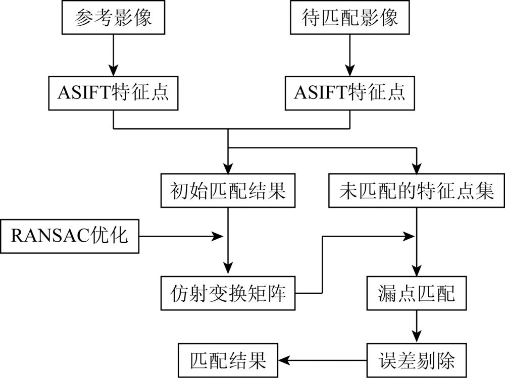
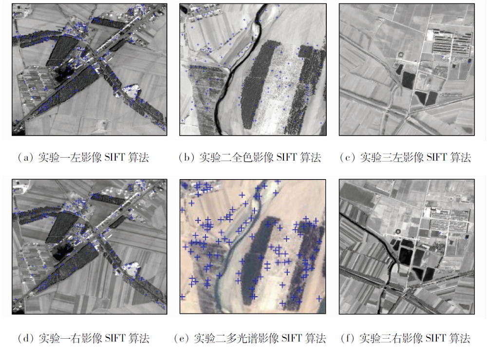
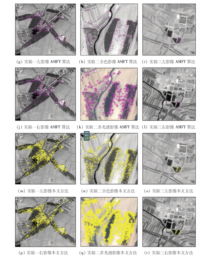
In order to solve the problem that there are large geometric deformation and gray difference between different remote sensing satellite image and it is difficult to match a large number of feature points, the authors put forward a multi-source remote sensing image matching method under multiple constraints in this paper. First, ASIFT algorithm is used to extract high-quality feature points and complete the initial matching, and the matching results are optimized by RANSAC algorithm. Secondly, affine transformation matrix of the two images is calculated by using the matching feature points set, and the remaining feature points are matched again by combining affine transformation and gray correlation coefficient. Finally, support vector regression (SVR) is used to check the matching results. Satellite images of ZY3-01, ZY3-02 and GF-1 were selected in the experiment. The experimental results show that, compared with SIFT and ASIFT algorithms, the proposed method can greatly increase the number of matching points between multi-source remote sensing images and improve the matching accuracy.
Wang J X, Zhang J. Adaptive window stereo matching algorithm combining local affine transformation[J]. Science of Surveying and Mapping, 2019,9(44):125-131.
Tang X M, Wang H Y, Zhu X Y. Technology and application of surveying and mapping for ZY-3 Satellites[J]. Acta Geodaetica et Cartographica Sinica, 2017,46(10):284-293.
[3]
谢萍. 基于Harris角点与SIFT特征的近景影像匹配[D]. 长沙:中南大学, 2011.
Xie P. Close-range image matching based on harris corners and SIFT features[D]. Changsha:Central South University, 2011.
Zhu H, Song W D, Yang D, et al. Dense matching method of inserting point into the Delaunay triangulation for close-range image[J]. Science of Surveying and Mapping, 2016,41(4):1032-1038.
Wang J X, Zhang J, Zhang X. A dense matching algorithm of close-range images constrained by iterative triangle network[J]. Journal of Signal Processing, 2018,34(3):347-356.
Zhu H, Song W D, Tan H, et al. A tiny facet primitive remote sensing image registration algorithm based on optimized delaunay triangulation[J]. Journal of Signal Processing, 2016,32(9):1032-1038.
Wang Q, Song W D, Wang J X. Stereo image dense matching method with triangle net constraint[J]. Geomatics & Spatial Information Technology, 2019,42(5):247-250.
Ye Y X, Shen L, Chen M, et al. An automatic matching method based on local phase feature descriptor for multi-source remote sensing images[J]. Geomatics and Information Science of Wuhan University, 2017,42(9):1278-1284.
Lu Di Lin X. An improved adaptive support-weight stereo matching algorithm with sparse region[J]. Journal of Harbin University of Science and Technology, 2016,21(1):83-88.
Ling Z G, Liang Y, Cheng Y M, et al. A robust multi-source remote-sensing image registration method based on feature matching[J]. Acta Electronica Sinica, 2010,38(12):2892-2897.
[11]
Lowe D G. Distinctive image features from scale-invariant keypoints[J]. International Journal of Computer Vision, 2004,60(2):91-110.
doi: 10.1023/B:VISI.0000029664.99615.94
Du C P, Li J S. A multi-sensor remote sensing image automatic matching method based on topological information and SIFT features[J].Bulletin of Surveying and Mapping 2017(10):125-129.
[13]
李建晔. 点、线结合下的多源高分辨率遥感影像匹配[D]. 阜新:辽宁工程技术大学, 2011.
Li J Y. The Matching of multi-source high resolution image based on points and lines[D]. Fuxin:Liaoning Technical University, 2011.
Qin X, Hou J. An improved SIFT-PCA algorithm application in image retrieval[J]. Journal of Southwest University of Science and Technology, 2011,26(4):65-70.
[15]
Mikolajczyk K, Schmid C. A performance evaluation of local descriptors[J]. IEEE Trans on Pattern Analysis and Matchine Intelligence, 2005,27(10):1615-1630.
[16]
Marr D, Poggio T. A computational theory of human stereo vision[J]. Proceedings of the Royal Society B(Biological Sciences), 1979,204(1156):301-328.
Guo J, Shen H, Li S X, et al. Global affine motion estimation for aerial video registration[J]. Application Research of Computers, 2011,28(6):2342-2345.
Hou W G, Wu Z C, Ding M Y. Densely stereo image matching using SURF and TPS[J]. Huazhong University of Science & Technology (Natural Science Edition), 2010,38(7):91-94.
[19]
Morel J M, Yu G. ASIFT:A new framework for fully affine invariant image comparison[J]. Siam Journal on Imaging Sciences, 2010,2(2):438-469.
doi: 10.1137/080732730
[20]
Kim T, Im Y J. Automatic satellite image registration by combination of matching and random sample consensus[J]. IEEE Transactions on Geoscience & Remote Sensing, 2003,41(5):1111-1117.
[21]
Fischler M A. Readings in computer vision random sample consensus:A paradigm for model fitting with applications to image analysis and automated cartography[J]. Readings in Computer Vision, 1987: 726-740.
Wang Z Y, Zhang K D, Wu Y, et al. Target tracking in infrared image sequences by combining SVM and Adaboost[J]. Journal of Image and Graphics, 2007,12(11):2052-2057.
doi: 10.11834/jig.20071118
Han J, Xie Y, Wu G X, et al. Research on the self-adaptive matching method of GF-1 satellite imagery considering the features of multi-camera mosaic imaging[J]. Remote Sensing for Land and Resources, 2017,29(4):13-19.doi: 10.6046/gtzyyg.2017.04.03.
 2020, Vol. 32
  ), 付钰莹2, 崔成玲3, 宋艳茹2, 赵世湖1