Fog removal effect optimization of aerial image based on dark channel prior
LI Li1(), HU Xiao2, PENG Jun1
1. Hubei Meteorological Information and Technical Support Center, Wuhan 430074, China 2. National Intellectual Property Administration, PRC Patent Bureau, Beijing 100088, China
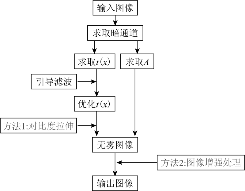
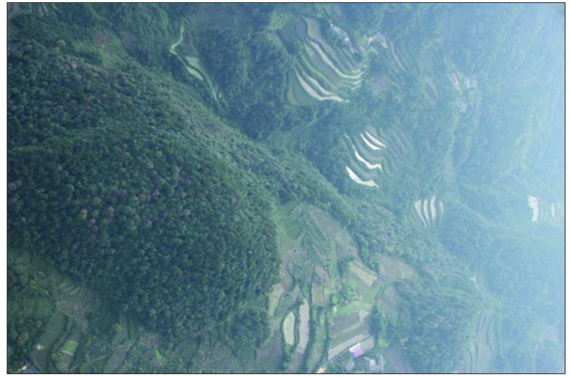
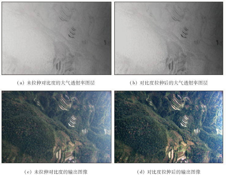
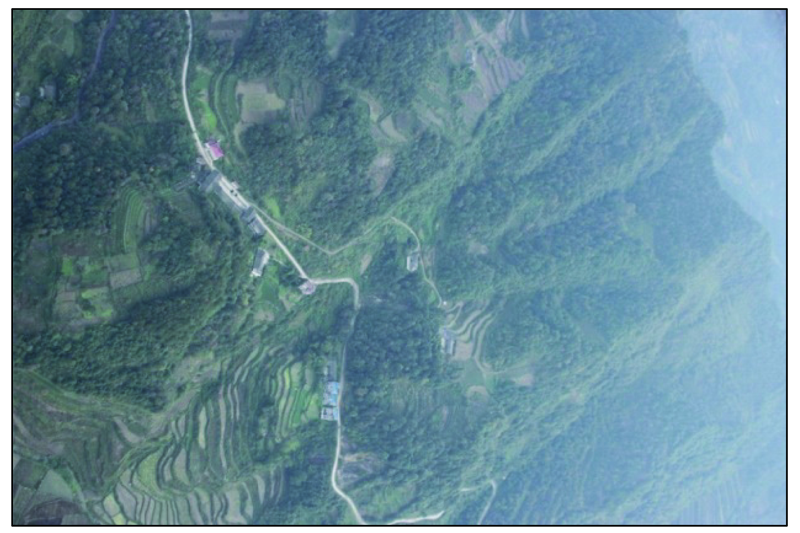
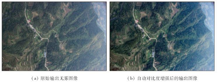
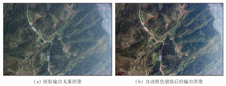
After observing a large number of aerial images, it is found that the effect is not ideal and the contrast is still not high. In this paper, through the study of the dark channel prior defogging algorithm, the process of fog image degradation is analyzed, and an aerial image defogging effect optimization method based on the dark channel prior is proposed. When the original image is uneven, the method of enhancing the contrast of atmospheric transmittance layer is used to improve the quality of the output image. In addition, for all the input images with fog, an image processing method of automatic contrast or automatic color enhancement is used to enhance the brightness of the output image. The optimization algorithm uses the objective image quality evaluation method without reference to evaluating the image effect before and after optimization. The analytical results show that, on the basis of ensuring the operation time, the optimized algorithm makes the output defog image more clear and meets the requirements of UAV aerial image data quality control.
李力, 胡潇, 彭军. 基于暗通道先验的航拍图像去雾效果优化[J]. 国土资源遥感, 2021, 33(1): 108-114.
LI Li, HU Xiao, PENG Jun. Fog removal effect optimization of aerial image based on dark channel prior. Remote Sensing for Land & Resources, 2021, 33(1): 108-114.
Oakley J P, Hong B. Correction of simple contrast loss in color images[J]. IEEE Transactions on Image Processing, 2007,16(2):511-522.
pmid: 17269643
[2]
Oakley J P, Satherley B L. Improving image quality in poor visibility conditions using a physical model for contrast degradation[J]. IEEE Transactions on Image Processing, 1998,7(2):167-179.
pmid: 18267391
[3]
Tan K K, Oakley J P. Physics-based approach to color image enhancement in poor visibility conditions[J]. Journal of the Optical Society of America A-Optics, 2001,18(10):2460-2467.
[4]
Wang W, Xu L. Retinex Algorithm on changing scales for haze removal with depth map[J]. International Journal of Hybrid Information Technology, 2014,7(4):353-364.
[5]
He K, Sun J, Tang X. Single image haze removal using dark channel prior[J]. IEEE Transactions on Pattern Analysis and Machine, 2011,33(12):2341-2353.
doi: 10.1109/TPAMI.2010.168
[6]
Narasimhan S G, Nayar S K. Vision and the atmosphere[J]. International Journal of Computer Vision, 2002,48(3):233-254.
[7]
Fiveland W A. Discrete-ordinates solutions of the radiative transport equation for rectangular enclosures[J]. Journal of Heat Transfer, 1984,106(4):699-706.
Song Y, Cai Z P. Normalized method of intrusion detection data based on information theory in big data environment[J]. Journal of Wuhan University(Natural Science Edition), 2018,64(2):121-126.
Cheng T, Li G Y, Bi K. Research on the geospatial correction method of water extracting products considering the characteristics of time points[J]. Remote Sensing for Land and Resources, 2019,31(2):96-101.doi: 10.6046/gtzyyg.2019.02.14.
Wang Z S, Dong B T, Zhao F C, et al. Improved dehazing method for traffic images based on dark channel prior[J]. Control and Decision, 2018,33(3):486-490.
Han L, Dai X A, Shao H Y, et al. An improved method for atmospheric transmissivity inversion based on field atmospheric modes[J]. Remote Sensing for Land and Resources, 2016,28(4):88-92.doi: 10.6046/gtzyyg.2016.04.14.
Tang M, Li Y S, Li X, et al. Local enhancement method and its applications to UAV image matching[J]. Remote Sensing for Land and Resources, 2013,25(4):53-57.doi: 10.6046/gtzyyg.2013.04.09.
Yao B X, Huang L, Xu Y S. A high resolution remote sensing image segmentation method based on superpixel and graph theory[J]. Remote Sensing for Land and Resources, 2019,31(3):72-79.doi: 10.6046/gtzyyg.2019.03.10.
Yuan Y C, Liu Y P, Gao H W. Image quality assessment method based on edge structure similarity[J]. Application Research of Computers, 2015,32(9):2870-2873.
 2021, Vol. 33
  ), 胡潇2, 彭军1