Application of information value model based on symmetrical factors classification method in landslide hazard assessment
LING Xiao1(), LIU Jiamei2,3(), WANG Tao2,3, ZHU Yueqin4, YUAN Lingling4, CHEN Yangyang1
1. School of Information Engineering and Technology, China University of Geosciences (Beijing), Beijing, 100083, China 2. Institute of Geomechanics, Chinese Academy of Geological Sciences, Beijing, 100081, China 3. Key Laboratory of Neotectonics Movement and Geohazard, Beijing, 100081, China 4. Development and Research Center, China Geological Survey, Beijing, 100037, China
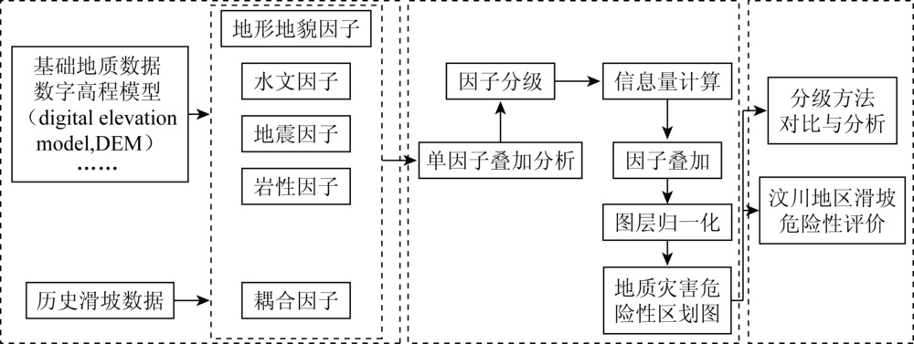
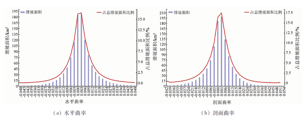
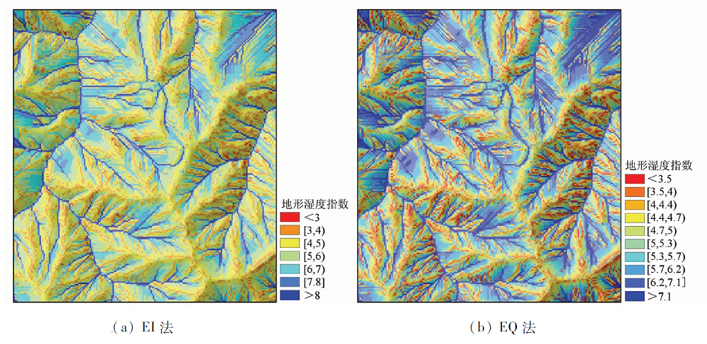
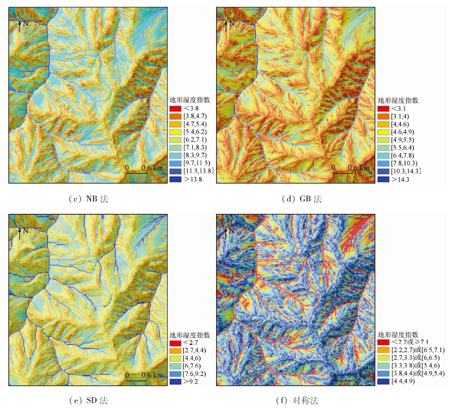
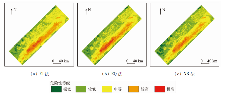
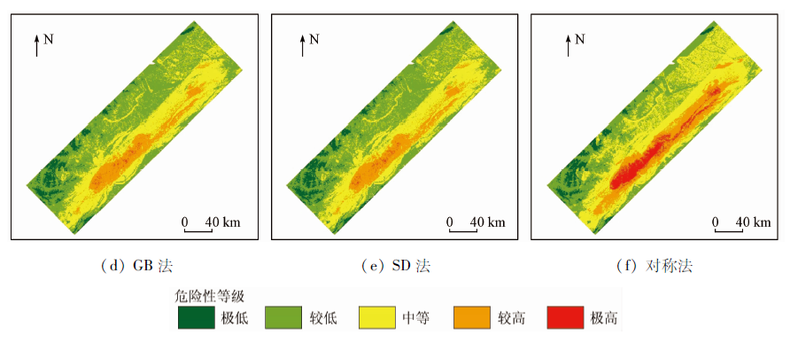
The information value model (IVM) is a statistical prediction method derived from information theory, which is widely used in natural hazard risk assessment. The problem as to how to formulate a suitable factor classification method to maximize the advantages of pre- single factor statistical analysis remains a key issue. In order to solve this problem, the authors processed a method of factor classification by combining symmetrical intervals. Statistical knowledge related to normal distribution was referred, the factors was pre-segmented by 1/2 standard deviation, and the intervals were merged symmetrically from outside to inside. After that, factors approximately fitting normal distribution, such as slope angel and topographic wetness index (TWI), were classified based on this method, and IVM was built, which was later used in landslide hazard susceptibility analysis in Wenchuan area. Meanwhile, 5 standard classification methods were selected and tested as comparative experiments for rationality verification, namely equal quantile (EQ) classification method, natural break (NB) classification method, geometric break (GB) classification method and standard deviation (SD) classification method. The results show that the IVM using symmetrical method as factor classification method stands out among the rests. The actual landslide area ratio in the high and extremely high-risk areas in the susceptibility map reached 80.87%, higher than that obtained by other standard classification methods. This proves that the symmetrical classification method performs well.
凌晓, 刘甲美, 王涛, 朱月琴, 袁玲玲, 陈扬洋. 基于致灾因子对称法分级的信息量模型在地震滑坡危险性评价中的应用[J]. 国土资源遥感, 2021, 33(2): 172-181.
LING Xiao, LIU Jiamei, WANG Tao, ZHU Yueqin, YUAN Lingling, CHEN Yangyang. Application of information value model based on symmetrical factors classification method in landslide hazard assessment. Remote Sensing for Land & Resources, 2021, 33(2): 172-181.
Liu F M, Zhang L H, Liu H Q, et al. Danger assessment of earthquake-included geological disasters in China[J]. Journal of Geomechanics, 2006, 12(2):127-131.
[3]
Pourghasemi H R, Pradhan B, Gokceoglu C. Application of fuzzy logic and analytical hierarchy process (AHP) to landslide susceptibility mapping at Haraz Watershed,Iran[J]. Natural Hazards, 2012, 63(2):965-996.
doi: 10.1007/s11069-012-0217-2
Liu L N, Xu C, Xu X W, et al.GIS-based landslide hazard evaluation using AHP method in the 2013 Lushan earthquake region[J]. Journal of Catastrophology, 2014(4):183-191.
He P, Tong L Q, Guo Z C, et al. Evaluation research on the landslide disaster liability in Zhada region of tibet[J]. Science Technology and Engineering, 2016, 16(25):193~200.
Zhuang J Q, Cui P, Ge Y G, et al. Distribution characteristics and impact factors assessment of collapses and landslides caused by 5.12 Wenchuan earthquake:Taking Dujiangyan-Wenchuan Highway as a sample[J]. Bulletin of Geological Science and Technology, 2009, 28(2):16-22.
[7]
He Y, Beighley R E. GIS-based regional landslide susceptibility mapping:A case study in southern California[J]. Earth Surface Processes & Landforms, 2010, 33(3):380-393.
[8]
Roberta P, Paolo F, Giuseppe S, et al. Landslide susceptibility assessment in Apulian southern Apennine:Heuristic vs.statistical method[J]. Environmental Earth Sciences, 2014, 72(4):1097-1108.
doi: 10.1007/s12665-013-3026-3
[9]
Yilmaz I. Comparison of landslide susceptibility mapping methodologies for Koyulhisar,Turkey:Conditional probability,logistic regression,artificial neural networks and support vector machine[J]. Environmental Earth Sciences, 2010, 61(4):821-836.
doi: 10.1007/s12665-009-0394-9
[10]
Youssef A M, Pourghasemi H R, Pourtaghi Z S, et al. Landslide susceptibility mapping using random forest,boosted regression tree,classification and regression tree and general linear models and comparison of their performance at Wadi Tayyah Basin,Asir region,Saudi Arabia[J]. Landslides, 2016, 13(5):839-856.
doi: 10.1007/s10346-015-0614-1
[11]
Wei C, Xie X S, Peng J B, et al. GIS-based landslide susceptibility evaluation using a novel hybrid integration approach of bivariate statistical based random forest method[J]. Catena, 2018, 164(5):135-149.
doi: 10.1016/j.catena.2018.01.012
Cong W Q, Pan M, Li T F, et al. Key research on landslide and debris flow hazard zonation based on GIS[J]. Earth Science Frontiers, 2006, 13(1):185-190.
[13]
Shannon C E. A mathematical theory of communication[J]. The Bell System Technical Journal, 1948, 27(8):623-656.
doi: 10.1002/bltj.1948.27.issue-4
[14]
Van W C. Statistical landslide hazard analysis[C]// Application Guide.ILWIS 21 for Windows.Enschede:ITC, 1997:73-84.
Du J, Yang Q H, Yan J, et al. Hazard evaluation of secondary geological disaster based on GIS and information value method[J]. Editorial Committee of Earth Science,Journal of China University of Geosciences, 2010, 35(2):168-174.
Luo Z F. Landslide hazard evaluation in debris flow catchment area based on GIS and information method[D]. Chengdu:Chengdu Univerisity of Technology, 2011.
[17]
Afungang R N, Valdir D M B C, Nkwemoh C A, Assessing the spatial probability of landslides using GIS and informative value model in the Bamenda highlands[J]. Arabian Journal of Geosciences, 2017, 10(17):384-399.
doi: 10.1007/s12517-017-3155-1
[18]
Laxmi D V, Rajeshwar B, Desh D P. Comparative evaluation of GIS based landslide hazard zonation maps using different approaches[J]. Journal of the Geological Society of India, 2019, 93(6):684-692.
doi: 10.1007/s12594-019-1247-0
[19]
Chen Y, Wang Q, Wei Y, et al. Application of information index model in landslide susceptibility mapping on Tonggu Jiangxi province,China[C]// IGARSS IEEE International Geoscience & Remote Sensing Symposium,IEEE, 2014.
[20]
殷坤龙. 滑坡灾害预测预报[M]. 北京: 中国地质大学出版社, 2004.
Yin K L. Forecast of landslide hazard[M]. Beijing: China University of Geosciences Press, 2004.
Xu C, Xu X W, Wu X Y, et al. Detailed catalog of landslides triggered by the 2008 Wenchuan earthquake and statistical analyses of their spatial distribution[J]. Journal of Engineering Geology, 2013, 21(1):27-46.
Lan H X, Wu F Q, Zhou C H, et al. GIS based spatial database for landslide assessment——A case study in Yunnan Xiaojiang river valley[J]. The Chinese Journal of Geological Hazard and Control, 2002, 13(4):10-16.
Meng X R, Pei X J, Liu Q H, et al. GIS-based susceptibility assessment of geological hazards along the road from Dujiangyan to Wenchuan by factor analysis[J]. The Chinese Journal of Geological Hazard and Control, 2016, 27(3):112-121.
Xu C, Dai F C, Yao X, et al. Earthquake triggered landslide susceptibility evaluation based on GIS platform and weight-of-evidence modeling[C]// Proceedings of the 10th (2010) Annual Conference of the Institute of Geology and Geophysics, Chinese Academy of Sciences, 2011.
Sun D L. Mapping landslide susceptibility based on machine learning and forecast warning of landslide induced by rainfall[D]. Shanghai:East China Normal University, 2019.
Zhao W D, Gong J H, Zhao J T, et al. Research on topographic wetness index and its implications of surface water environment considering micro-reliefs on plains[J]. Journal of Hefei University of Technology(Natural Science), 2019, 42(1):119-124.
Tao S, Hu D Y, Zhao W J, et al. Susceptibility assessment of secondary landslides triggered by earthquakes:A case study of northern Wenchuan[J]. Geographical Research, 2010, 29(9):60-71.
 2021, Vol. 33
  ), 刘甲美2,3(