Application of domestic low-cost micro-satellite images in urban bare land identification
SUN Yiming1(), ZHANG Baogang1(), WU Qizhong1, LIU Aobo1, GAO Chao2, NIU Jing3, HE Ping3
1. College of Global Change and Earth System Science, Beijing Normal University, Beijing 100875, China 2. Unit 63921 of People’s Liberation Army, Beijing 100094, China 3. Shenzhen Aerospace Dongfanghong Satellite Ltd., Shenzhen 518000, China
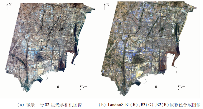
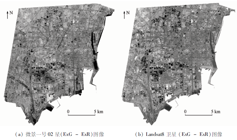
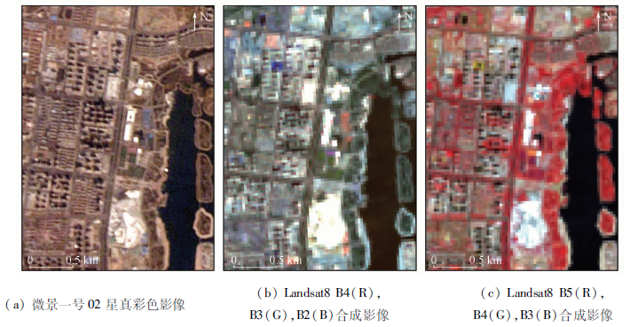
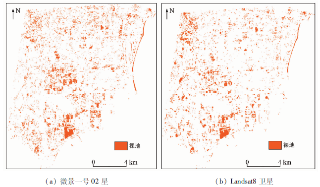
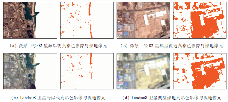
Low-cost microsatellites and their constellations are important directions in the development of satellite remote sensing in recent years. This is because they can effectively alleviate the questions such as the low transit frequency of a single satellite and the high networking cost of satellites. Monitoring using remote sensing satellites is an important means to obtain bare land information in the ecological field owing to its wide coverage area and immunity to man-made interference. This study carried out exploratory research on urban bare land identification using the remote sensing images of low-cost micro-satellites of MV-1 Constellation. The identification results were compared to those obtained using Landsat8 images to explore the reliability of the implication of domestic low-cost micro-satellite images in urban bare land identification. To this end, this study selected Donggang District, Rizhao City, Shandong Province as an example and developed the extraction method that combines unsupervised vegetation indices-excess green and excess red (ExG-ExR)-with the maximum likelihood method. The results are as follows. ① The panchromatic images with a resolution of 5 m that were shot by Micro-satellite No. 02 of MV-1 Constellation can clearly reflect the current status of Donggang District. They have higher resolution and perform better in capturing details of ground features. However, they lack wave band advantages over Landsat8 images. ② The images of Micro-satellite No. 02 had an overall classification accuracy of 93.3% and a Kappa coefficient of up to 0.85. Therefore, the micro-satellites of MV-1 Constellation are reliable in bare land identification to some extent. ③ The difference between the bare land area in the Donggang urban area identified using Micro-satellite No. 02 images and Landsat8 images was 1.5 percentage points. This indicates that micro-satellites of MV-1 Constellation have equivalent inversion capacity in urban bare land identification to mainstream satellites under the conditions of proper algorithms, close shooting time, and consistent geo-coordinate correction.
Hu M, Tang Q, Peng J F, et al. Study on characterization and source apportionment of atmospheric particulate matter in China[J]. Environment and Sustainable Development, 2011, 36(5):15-19.
Huang H J, Liu H N, Jiang W M, et al. Physical and chemical characteristics and source apportionment of PM2.5 in Nanjing[J]. Climatic and Environmental Research, 2006, 11(6):713-722.
Chen R M, Wu Y, Kang W Y, et al. Analysis of pollutant concentrations and characteristics of continuous smoggy weather[J]. Climatic and Environmental Research, 2014, 19(2):209-218.
Wang S K, Wang T J, Shi R, et al. Estimation of different fugitive dust emission inventory in Nanjing[J]. Journal of University of Chinese Academy of Sciences, 2014, 31(3):351-359.
Fang X Z, Sun L, Bi X H, et al. The chemical compositions and sources apportionment of re-suspended dust in Ningbo[J]. Environmental Pollution and Control, 2014, 36(1):55-59.
[6]
Gillette D A, Passi R. Modeling dust emission caused by wind erosion[J]. Journal of Geophyysical Research-Atmospheres, 1988, 93(d11):14233-14242.
Pan Y Y, Li N, Zheng J Y, et al. Emission inventory and characteristics of anthropogenic air pollutant sources in Guangdong Province[J]. Acta Scientiae Circumstantiae, 2015, 35(9):2655-2669.
Xue Y F, Zhou Z, Huang Y H, et al. Fugitive dust emission characteristics from building construction sites of Beijing[J]. Environmental Science, 2017, 38(6):2231-2237.
Liu A B, Wu Q Z, Chen Y T, et al. Estimation of dust emissions from bare soil erosion over Beijing plain area[J]. China Environmental Science, 2018, 38(2):471-477.
Yang W F, Cheng Z, Zhang J, et al. Research on emission inventory and distribution characteristics of wind erosion dust from bare ground in Changzhou[J]. The Administration and Technique of Environmental Monitoring, 2020, 32(2):56-60.
Xiong W C, Xu Y M, Li J R, et al. Urban dust pollution sources monitoring based on medium and high resolution satellite imagery in Tianjin[J]. Remote Sensing Information, 2017, 32(3):45-49.
Deng Y Y, Wu Z C, Yi L N, et al. Research on object-oriented classification of agricultural land based on high resolution images[J]. Remote Sensing for Land and Resources, 2010, 22(4):117-121.doi: 10.6046/gtzyyg.2016.02.15.
doi: 10.6046/gtzyyg.2016.02.15
Li L, Ying G W, Wen X H, et al. Classification of high spatial resolution remotely sensed images by temporal feature fusion[J]. Remote Sensing for Land and Resources, 2016, 28(2):91-98.doi: 10.6046/gtzyyg.2016.02.15.
doi: 10.6046/gtzyyg.2016.02.15
Xu Y Q, Jiang N, Yan Q S, et al. Research on emission inventory of bareness wind erosion dust in Zhengzhou[J]. Environmental Pollution and Control, 2016, 38(4):22-27.
Zhang L K, Li L J, Jiang L, et al. Spatial and temporal distribution characteristics and fugitive dust emission of building sites in Beijing[J]. Environmental Science, 2019, 40(1):135-142.
doi: 10.1021/es048761f
Li D, Mei X D, Zhao H, et al. Comparative analysis of GF-1 and Landsat8 image land use remote sensing interpretation[J]. Engineering of Surveying and Mapping, 2018, 27(10):42-45.
[18]
牛静. 京师一号卫星[J]. 卫星应用, 2019(10):70.
Niu J. Jingshi-1(BNU-1) microsat[J]. Satellite Application, 2019(10):70.
Xu H Q, Tang F. Analysis of new characteristics of the first Landsat8 image and their ecoenvironmental significance[J]. Acta Ecologica Sinica, 2013, 33(11):3249-3257.
doi: 10.5846/stxb
Wang Z W, Sun J J, Yu Z Y, et al. Review of remote sensing image classification based on support vector machine[J]. Computer Science, 2016, 43(9):11-17.
Wu F Q, Ma H Z, Sha Z J, et al. Combining the decision tree and supervised,unsupervised technique to classify the satellite images[J]. Journal of Salt Lake Research, 2005, 13(4):9-13.
Bo Y C, Wang J F. Combining multiple classifiers for thematic classification of remotely sensed data[J]. Journal of Remote Sensing, 2005, 9(5):555-563.
Wu Z J, Zhao S H. A study of enhanced index-based built-up index based on Landsat TM imagery[J]. Remote Sensing for Land and Resources, 2012, 24(2):50-55.doi: 10.6046/gtzyyg.2012.02.10.
doi: 10.6046/gtzyyg.2012.02.10
[24]
Meyer G E, Neto J C. Verification of color vegetation indices for automated crop imaging applications[J]. Computers and Electronics in Agriculture, 2008, 63(2):282-293.
doi: 10.1016/j.compag.2008.03.009
[25]
Woebbecke D M, Meyer G E, Vonbargen K, et al. Color indexes for weed identification under various soil,residue,and lighting conditions[J]. Transactions of The ASAE, 1995, 38(1):259-269.
doi: 10.13031/2013.27838
[26]
Meyer G, Hindman T, Laksmi K. Machine vision detection parameters for plant species identification[J]. Proceedings of SPIE - The International Society for Optical Engineering, 1999, 3543.
[27]
Sezgin M, Sankur B. Survey over image thresholding techniques and quantitative performance evaluation[J]. Journal of Electronic Imaging, 2004, 13(1):146-168.
doi: 10.1117/1.1631315
Cui F N, Song X Y, Sun B S, et al. Change detection of winter wheat area based on multi-temporal TM images[J]. Remote Sensing Information, 2012, 27(5):89-95.
Wu Y Q, Meng T L, Wu S H. Research progress of image thresholding methods in recent 20 years(1994—2014)[J]. Journal of Data Acquisition and Processing, 2015, 30(1):1-23.
[30]
周钰哲. 微小卫星特性与应用发展概述[J]. 数字通信世界, 2018(12):26-27.
Zhou Y Z. Overview of microsatellite characteristics and application development[J]. Digital Communication World, 2018(12):26-27.
 2022, Vol. 34
  ), 张宝钢1(