Classification of wolfberry planting areas based on ensemble learning and multi-temporal remote sensing images
SHI Feifei1,2,3,4,5(), GAO Xiaohong1,3,4,6(), XIAO Jianshe2,5, LI Hongda1,3,4, LI Runxiang1,3,4, ZHANG Hao1,3,4
1. School of Geographical Sciences, Qinghai Normal University, Xining 810008, China 2. Institute of Qinghai Meteorological Science Research, Xining 810008, China 3. Key Laboratory of Physical Geography and Environmental Process of Qinghai Province, Xining 810008, China 4. Ministry of Education Key Laboratory of Tibetan Plateau Land Surface Processes and Ecological Conservation, Xining 810008, China 5. Key Laboratory of Disaster Prevention and Mitigation of Qinghai Province, Xining 810008, China 6. Academy of Plateau Science and Sustainability, Xining 810008, China
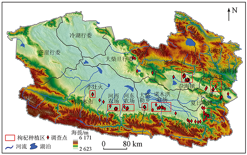
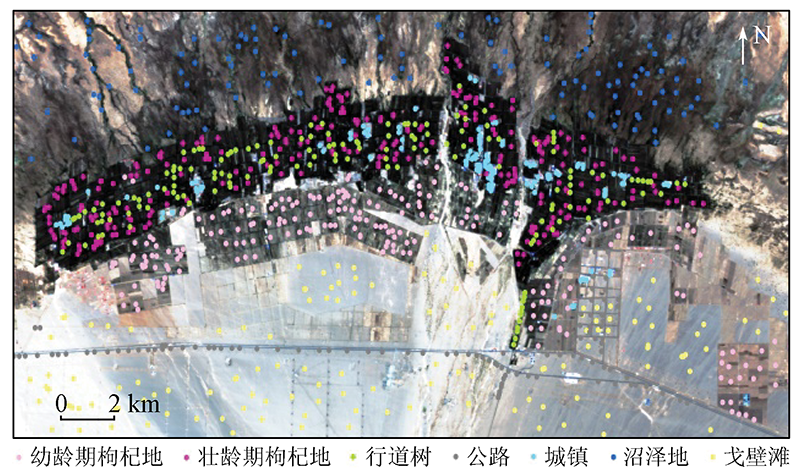
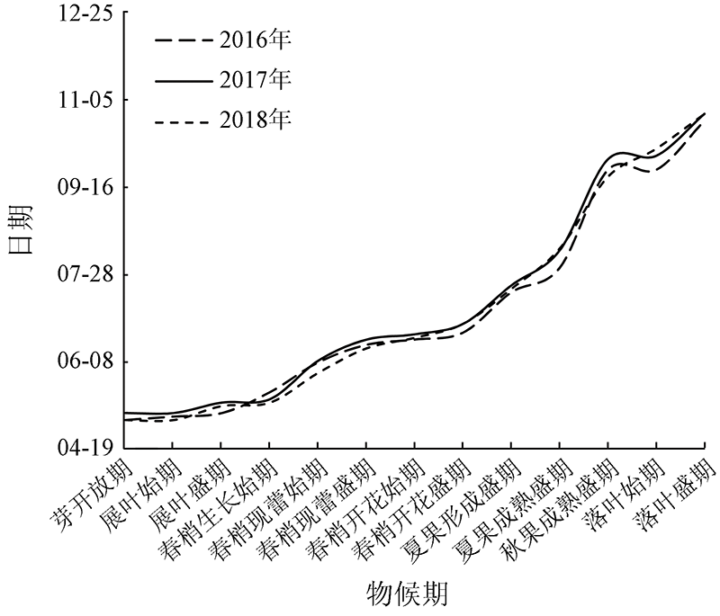
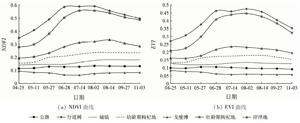
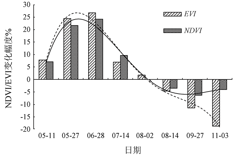
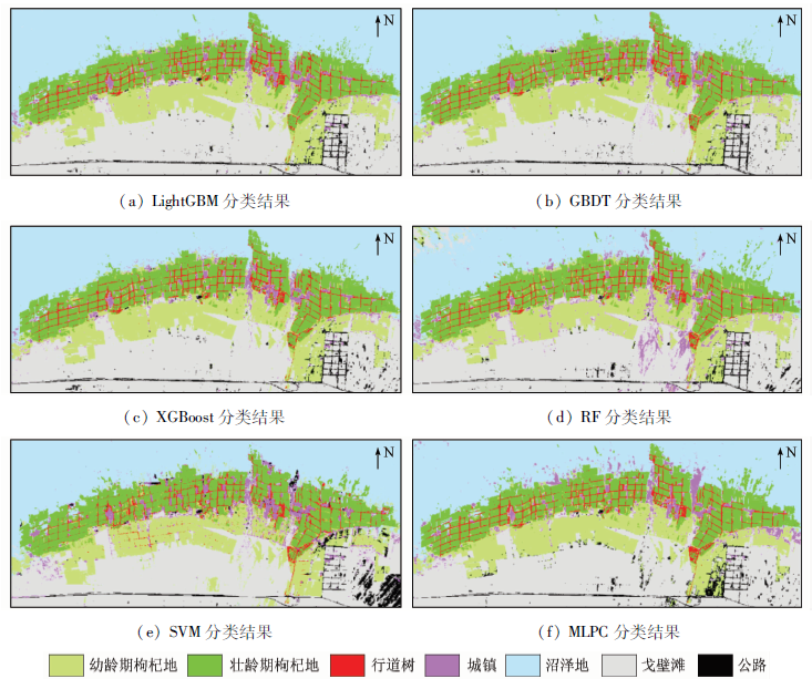
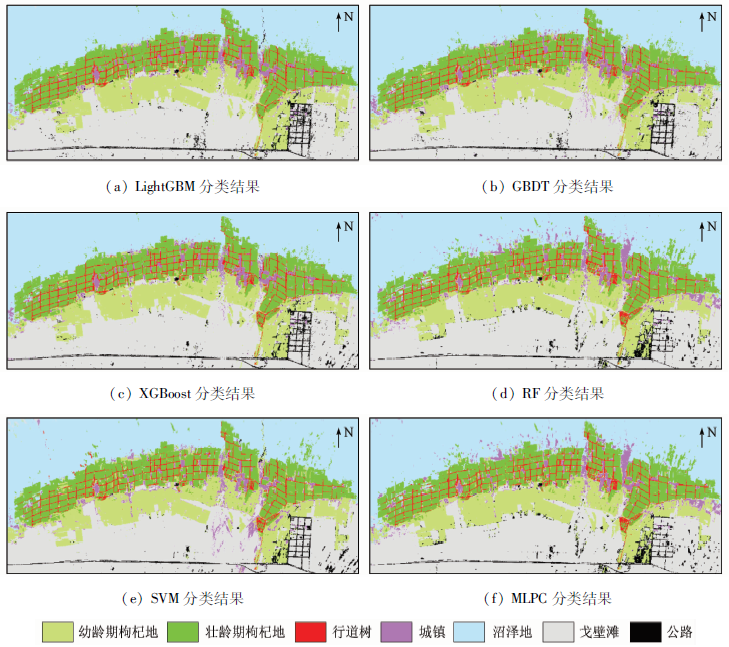
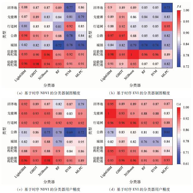
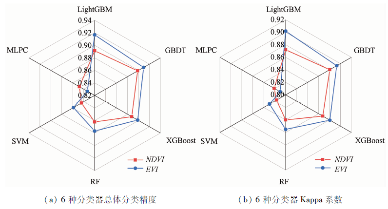
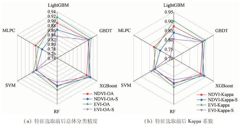
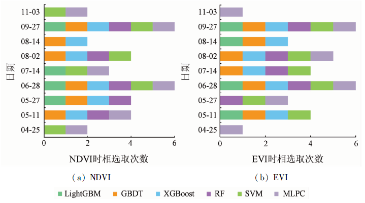
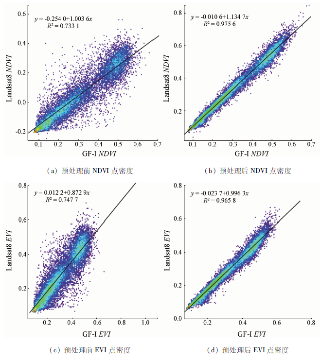
It is significant for the market management and regulation of local government to accurately extract wolfberry planting areas in the Qaidam Basin using remote sensing technology. Taking the Nuomuhong Farm, a typical wolfberry planting area, as an example, this study selected Landsat8 OLI and GF-1 WFV images to construct the time-series NDVI/EVI data of the crop growth period. Then, this study employed four novel ensemble learning classifiers (i.e., LightGBM, GBDT, XGBoost, and RF) and two widely used machine learning classifiers (SVM and MLPC) to classify wolfberry planting areas. The results show that: ① Relatively high classification accuracy were obtained using LightGBM (90.4%), GBDT (90.4%), XGBoost (89.31%), and RF (86.96%). Most especially, LightGBM-EVI yielded the highest overall classification accuracy (91.67%), with a Kappa coefficient of 0.90; ② Enhanced vegetation index (EVI) is more sensitive in the middle-late stage of the wolfberry growth period. For the same classifier, better mapping effects of wolfberry planting areas can be obtained when time-series EVI data were used; ③ Data redundancy can be further reduced while obtaining high classification accuracy by determining the optimal temporal features of NDVI/EVI classification using the feature importance scores of the GBDT, XGBoost, and RF classifiers.
史飞飞, 高小红, 肖建设, 李宏达, 李润祥, 张昊. 基于集成学习和多时相遥感影像的枸杞种植区分类[J]. 自然资源遥感, 2022, 34(1): 115-126.
SHI Feifei, GAO Xiaohong, XIAO Jianshe, LI Hongda, LI Runxiang, ZHANG Hao. Classification of wolfberry planting areas based on ensemble learning and multi-temporal remote sensing images. Remote Sensing for Natural Resources, 2022, 34(1): 115-126.
Xu C Q, Liu S, Xu R, et al. Investigation of production status in major wolfberry producing areas of China and some suggestions[J]. China Journal of Chinese Materia Medica, 2014, 39(11):1979-1984.
Zhu S J, Xie S J, Yu Q Y, et al. Research on the problem of supply and demand mismatch of special agricultural products in remote areas:Taking Qinghai wolfberry as an example[J]. Modern Business Trade Industry, 2020, 41(2):25-27.
Dong J W, Wu W B, Huang J X, et al. State of the art and perspective of agricultural land use remote sensing information extraction[J]. Journal of Geo-Information Science, 2020, 22(4):772-783.
[4]
Yi Z W, Jia L, Chen Q T. Crop classification using multi-temporal Sentinel-2 data in the Shiyang River basin of China[J]. Remote Sensing, 2020, 12(24):4052-4073.
doi: 10.3390/rs12244052
[5]
Zhong L H, Gong P, Biging G S. Efficient corn and soybean mapping with temporal extendability:A multi-year experiment using Landsat imagery[J]. Remote Sensing of Environment, 2014, 140:1-13.
doi: 10.1016/j.rse.2013.08.023
[6]
Conese C, Maselli F. Use of multitemporal information to improve classification performance of TM scenes in complex terrain[J]. ISPRS Journal of Photogrammetry and Remote Sensing, 1991, 46(4):187-197.
doi: 10.1016/0924-2716(91)90052-W
[7]
Pena M A, Brenning A. Assessing fruit-tree crop classification from Landsat8 time series for the Maipo Valley,Chile[J]. Remote Sensing of Environment, 2015, 171:234-244.
doi: 10.1016/j.rse.2015.10.029
[8]
Lobell D B, Asner G P. Cropland distributions from temporal unmixing of MODIS data[J]. Remote Sensing of Environment, 2004, 93:412-422.
doi: 10.1016/j.rse.2004.08.002
[9]
Richard M, Sankey T T, Congalton R G, et al. MODIS phenology-derived,multi-year distribution of conterminous US crop types[J]. Remote Sensing of Environment, 2017, 198:490-503.
doi: 10.1016/j.rse.2017.06.033
Xu Q Y, Yang G J, Long H L, et al. Crop information identification based on MODIS NDVI time-series data[J]. Transactions of the Chinese Society of Agricultural Engineering, 2014, 30(11):134-144.
Ping Y P, Zang S Y. Crop identification based on MODIS NDVI time-series data and phenological characteristics[J]. Journal of Natural Resources, 2016, 31(3):503-514.
Guo Y S, Liu Q S, Liu G H, et al. Extraction of main crops in Yellow River delta based on MODIS NDVI time series[J]. Journal of Natural Resources, 2017, 32(10):1808-1818.
Wang X Q, Qiu P X, Li Y L, et al. Crops identification in Kaikong River basin of Xinjiang based on time series Landsat remote sensing images[J]. Transactions of the Chinese Society of Agricultural Engineering, 2019, 35(16):180-188.
Bai Y Y, Gao J L, Zhang B L. Extraction of crop planting structure based on time-series NDVI of Landsat8 images[J]. Arid Land Geography, 2019, 42(4):893-901.
[15]
Pareeth S, Karimi P, Shafiei M, et al. Mapping agricultural landuse patterns from time series of Landsat8 using random forest based hierarchial approach[J]. Remote Sensing, 2019, 11(5):601-615.
doi: 10.3390/rs11050601
Wei P F, Xu X G, Yang G J, et al. Remote sensing classification of crops based on the change characteristics of multi-phase vegetation index[J]. Journal of Agricultural Science and Technology, 2019, 21(2):54-61.
Du B J, Zhang J, Wang Z M, et al. Crop mapping based on Sentinel-2A NDVI time series using object-oriented classification and decision tree model[J]. Journal of Geo-Information Science, 2019, 21(5):740-751.
[19]
Ali N, Nicolas B, Mario M, et al. A novel approach for mapping wheat areas using high resolution Sentinel-2 images[J]. Sensors, 2018, 18(7):2089-2110.
doi: 10.3390/s18072089
[20]
Vrieling A, Meroni M, Darvishzadeh R, et al. Vegetation phenology from Sentinel-2 and field cameras for a Dutch Barrier island[J]. Remote Sensing of Environment, 2018, 215:517-529.
doi: 10.1016/j.rse.2018.03.014
Gu X H, Zhang Y, Sang H Y, et al. Research on crop classification method based on Sentinel-2 time series combined vegetation index[J]. Remote Sensing Technology and Application, 2020, 35(3):702-711.
Li Y F, Dong H B. Classification of remote sensing image based on convolutional neural network[J]. CAAI Transactions on Intelligent Systems, 2018, 13(4):550-556.
[23]
Masoud M, Bahram S, Mohammad R, et al. Very deep convolutional neural networks for complex land cover mapping using multispectral remote sensing imagery[J]. Remote Sensing, 2018, 10(7):1119-1140.
doi: 10.3390/rs10071119
Xu G Z, Xu H Q. Cross-comparison of Sentinel-2A MSI and Landsat8 OLI multispectral information[J]. Remote Sensing Technology and Application, 2021, 36(1):165-175.
[25]
Mancino G, Ferrara A, Padula A, et al. Cross-comparison between Landsat8(OLI)and Landsat7(ETM+)derived vegetation indices in a mediterranean environment[J]. Remote Sensing, 2020, 12(2):291-311.
doi: 10.3390/rs12020291
Shi F F, Lei C M, Xiao J S, et al. Classification of crops in complicated topography area based on multisource remote sensing data[J]. Geography and Geo-Information Science, 2018, 34(5):49-55,2.
[27]
Zhang H, Li Y, Jiang Y, et al. Hyperspectral classification based on Lightweight 3-D-CNN with transfer learning[J]. IEEE Transactions on Geoscience and Remote Sensing, 2019, 57(8):5813-5828.
doi: 10.1109/TGRS.36
[28]
Markus I, Clement A, Tatjana K. Tree species classification with random forest using very high spatial resolution 8-band WorldView-2 satellite data[J]. Remote Sensing, 2012, 4(9):2661-2693.
doi: 10.3390/rs4092661
Cai Y T, Liu S T, Lin H, et al. Extraction of paddy rice based on convolutional neural network using multi -source remote sensing data[J]. Remote Sensing for Land and Resources, 2020, 32(4):97-104.doi: 10.6046 /gtzyyg.2020.04.14.
doi: 10.6046 /gtzyyg.2020.04.14
Cui Y L, Liu F, Hao Q C, et al. Characteristics of hydrogen and oxygen isotopes and renewability of groundwater in the Nuomuhong alluvial fan[J]. Hydrogeology and Engineering Geology, 2015, 42(6):1-7.
[31]
Foga S, Scaramuzza P L, Guo S, et al. Cloud detection algorithm comparison and validation for operational Landsat data products[J]. Remote Sensing of Environment, 2017, 194:379-390.
doi: 10.1016/j.rse.2017.03.026
[32]
Villa P, Bresciani M, Braga F, et al. Comparative assessment of broadband vegetation indices over aquatic vegetation[J]. IEEE Journal of Selected Topics in Applied Earth Observations and Remote Sensing, 2014, 7(7):3117-3127.
doi: 10.1109/JSTARS.4609443
Bai Y Y, Gao J L, Zhang B L. Monitoring of crops growth based on NDVI and EVI[J]. Transactions of the Chinese Society for Agricultural Machinery, 2019, 50(9):153-161.
Xie Y, Zhang Y Q, Xun L, et al. Crop classification based on multi-source remote sensing data fusion and LSTM algorithm[J]. Transactions of the Chinese Society of Agricultural Engineering, 2019, 35(15):129-137.
[35]
Huang G M, Wu L F, Ma X, et al. Evaluation of CatBoost method for prediction of reference evapotranspiration in humid regions[J]. Journal of Hydrology, 2019, 574:1029-1041.
doi: 10.1016/j.jhydrol.2019.04.085
[36]
Su H, Yang X, Lu W F, et al. Estimating subsurface thermohaline structure of the global ocean using surface remote sensing observations[J]. Remote Sensing, 2019, 11(13):1598-1620.
doi: 10.3390/rs11131598
[37]
周志华. 机器学习[M]. 北京: 清华大学出版社, 2016:171-196.
Zhou Z H. Machine learning[M]. Beijing: Tsinghua University Press, 2016:171-196.
Li H D, Gao X H, Tang M. Land cover classification for different spatial resolution images from CNN[J]. Remote Sensing Technology and Application, 2020, 35(4):749-758.
[39]
Pleoianu A I, Stupariu M S, Sandric I, et al. Individual tree-crown detection and species classification in very high-resolution remote sensing imagery using a deep learning ensemble model[J]. Remote Sensing, 2020, 12(15):2426-2448.
doi: 10.3390/rs12152426
Song J W, Zhang Y J, Li X C, et al. Comparison between GF-1 and Landsat8 images in land cover classification[J]. Progress in Geography, 2016, 35(2):255-263.
[41]
Vasilakos C, Kavroudakis D, Georganta A. Machine learning classification ensemble of multitemporal Sentinel-2 images:The case of a mixed mediterranean ecosystem[J]. Remote Sensing, 2020, 12(12):2005-2030.
doi: 10.3390/rs12122005
 2022, Vol. 34
  ), 高小红1,3,4,6(