Estimation of maize seedling number based on UAV multispectral data
ZHAO Xiaowei1,2(), HUANG Yang1(), WANG Yongqiang1, CHU Ding1
1. Heilongjiang Provincial Research Institute of Surveying and Mapping, Harbin 150081, China 2. Northeast Institute of Geography and Agroecology, Chinese Academy of Sciences, Changchun 130102, China
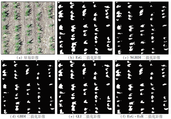
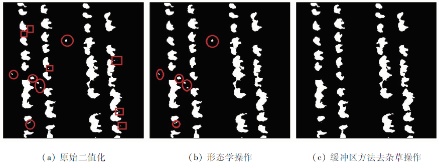
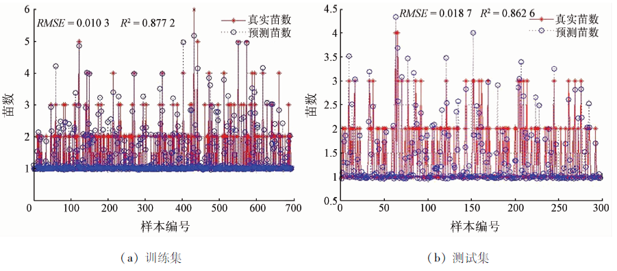
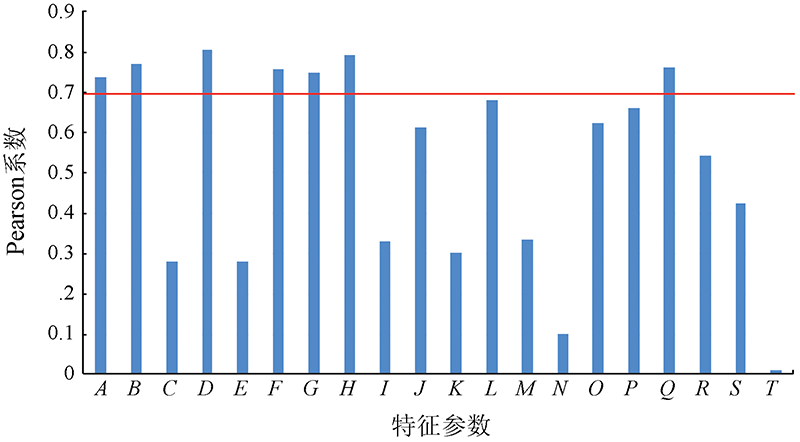
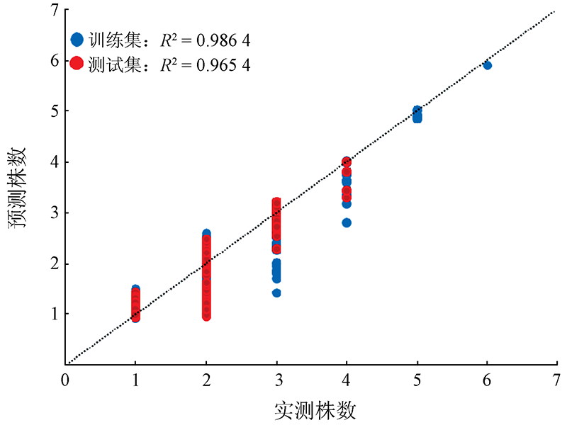
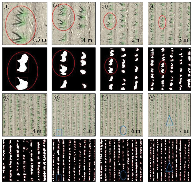
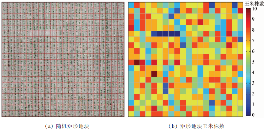
To monitor and evaluate maize seedlings in Northeast China and estimate their number in time, this study provided effective support for the rapid estimation of the maize seedling number using unmanned aerial vehicle (UAV) remote sensing images. Using the multispectral UAV data, the color indexes ExG, GBDI, ExG-ExR, NGRDI, and GLI were compared to segment maize seedlings from the soil background. Then, the optimal threshold was determined using the Otsu algorithm, and ExG was selected as the optimal color index. According to optimization, the best combination of morphological parameters consists of area (A), perimeter (B), rectangle length (D), rectangle perimeter (G), ellipse long axis length (H), and shape factor (Q). Then, the number of maize seedlings was predicted using the support vector regression (SVR) model and the prediction accuracy was assessed. Finally, the spatial distribution map of the local maize seedling number was developed. Tests revealed that the accuracy and the statistical error of the SVR model were 96.54% and 0.6%, respectively. These results allow the number and growth trends of maize seedlings to be predicted quickly and accurately in a short time.
Liu P, Guo W S, Xu Y M, et al. Effect of planting density on grain yield and quality of weak gluten and medium-gluten wheat[J]. Journal of Triticeae Crops, 2006, 26:117-121.
Dai J G, Zhang G S, Guo P, et al. Information extraction of cotton lodging based on multi-spectral image from UAV remote sensing[J]. Transactions of the Chinese Society of Agricultural Engineering, 2019, 35(2):63-70.
[5]
Mitch B, Reid A, Ramos F, et al. Airbornevision based mapping and classification of large farmland environments[J]. Journal of Field Robotics, 2010, 27(5):632-655.
doi: 10.1002/rob.20343
Ding L L, Li Q Z, Du X, et al. Vegetation extraction method based on color indices from UAV images[J]. Remote Sensing for Land and Resources, 2016, 28(1):78-86.doi: 10.6046/gtzyyg.2016.01.12.
doi: 10.6046/gtzyyg.2016.01.12
Wang X Q, Wang M M, Wang S Q, et a1. Extraction of vegetation information from visible unmanned aerial vehicle images[J]. Transactions of the Chinese Society of Agricultural Engineering, 2015, 31(5):152-159.
Lan Y B, Deng X L, Zeng G L. Advances in diagnosis of crop diseases,pests and weeds by UAV remote sensing[J]. Smart Agriculture, 2019, 1(2):1-19.
[9]
Zheng X L, Zhang X F, Cheng J Y, et al. Using the multispectral image data acquired by unmanned aerial vehicle to build an estimation model of the number of seedling stage cotton plants[J]. Journal of Image and Graphics, 2020, 25(3):520-534.
Dai J G, Xue J L, Zhao Q Z, et al. Extraction of cotton seedling growth information using UAV visible light remote sensing images[J]. Transactions of the Chinese Society of Agricultural Engineering, 2020, 36(4):63-71.
Liu S B, Yang G J, Zhou C Q, et al. Extraction of maize seedling number information based on UAV imagery[J]. Transactions of the Chinese Society of Agricultural Engineering, 2018, 34(22):69-77.
[12]
Zhao B, Zhang J, Yang C H, et al. Rapeseed seedling stand counting and seeding performance evaluationat two early growth stages based on unmanned aerial vehicle imagery[J]. Frontiers in Plant Science, 2018, 9:1362.
doi: 10.3389/fpls.2018.01362
[13]
Han L, Yang G J, Dai H Y, et al. Modeling maize above-ground biomass based on machine learning approaches using UAV remote-sensing data[J]. Plant Methods, 2019, 15(1):10.
doi: 10.1186/s13007-019-0394-z
[14]
Woebbecke D M, Meyer G E, Bargen K V, et al. Color indices for weed identification under various soil,residue,and lighting conditions[J]. Transactions of the ASABE, 1995, 38(1):259-269.
[15]
Verrelst J, Schaepman M E, Koetz B, et al. Angular sensitivity analysis of vegetation indices derived from CHRIS/PROBA data[J]. Remote Sensing of Environment, 2008, 112(5):2341-2353.
doi: 10.1016/j.rse.2007.11.001
[16]
Motohka T, Nasahara K N, Oguma H, et al. Applicability of green-red vegetation index for remote sensing of vegetation phenology[J]. Remote Sensing, 2010, 2(10):2369-2387.
doi: 10.3390/rs2102369
[17]
Liu G R, Huang Z, Mao S C, et al. Application study about OTSU optimal threshold method in cotton seedling recognition[J]. Cotton Science, 2013, 25(1):86-89.
Liu G R, Huang Z, Mao S C, et al. Application study about OTSU optimal threshold method in cotton seedling recognition[J]. Cotton Science, 2013, 25(1):86-89.
[19]
Otsu N. A threshold selection method from gray-level histograms[J]. IEEE Transactions on Systems,Man and Cybernetics, 1979, 9(1):62-66.
doi: 10.1109/TSMC.1979.4310076
[20]
Pal M. Kernel methods in remote sensing:A review[J]. ISH Journal of Hydraulic Engineering, 2009:15194-15215.
[21]
Bakhshipour A, Jafari A. Evaluation of support vector machine and artificial neural networks in weed detection using shape features[J]. Computers and Electronics in Agriculture, 2018, 145:153-160.
doi: 10.1016/j.compag.2017.12.032
[22]
Zheng Y, Zhu Q B, Huang M, et al. Maize and weed classification using color indices with support vector data description in outdoor fields[J]. Computers and Electronics in Agriculture, 2017, 141:215-222.
doi: 10.1016/j.compag.2017.07.028
 2022, Vol. 34
  ), 黄杨1(