Please wait a minute...
 
自然资源遥感  2023, Vol. 35 Issue (1): 258-264    DOI: 10.6046/zrzyyg.2021428
  地理信息系统 本期目录 | 过刊浏览 | 高级检索 |
基于云+端的天基遥感服务模式研究
龙恩(), 吕守业(), 钱国栋, 连翠萍, 杨宇科, 陈玲艳
北京市遥感信息研究所,北京 100011
A space-based remote sensing service mode based on cloud+ terminals
LONG En(), LYU Shouye(), QIAN Guodong, LIAN Cuiping, YANG Yuke, CHEN Lingyan
Institute of Remote Sensing Information of Beijing, Beijing 100011, China
全文: PDF(1685 KB)   HTML  
输出: BibTeX | EndNote (RIS)      
摘要 

随着我国各类民商卫星的蓬勃发展及应用的不断深入,为满足不同用户日趋复杂的天基遥感应用需求,针对目前天基遥感服务应用模式单一、针对性不强、灵活性不够等问题,本文在分析各类遥感用户主要应用需求基础上,研制提出基于云+端的天基遥感应用服务模式,设计了3大类8小类的具体服务模式构成,并对各服务模式特点、应用流程等进行详细分析及制定,最后给出单人独立及多人协同两种典型场景下潜在应用。研究成果为各类天基遥感地面系统研制建设及优化奠定基础,促进面向不同遥感用户、不同应用需求、不同应用场景下的天基遥感服务能力的进一步提升。

服务
把本文推荐给朋友
加入引用管理器
E-mail Alert
RSS
作者相关文章
龙恩
吕守业
钱国栋
连翠萍
杨宇科
陈玲艳
关键词 天基遥感云+端应用需求服务模式应用流程    
Abstract

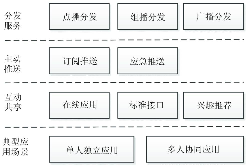
With the vigorous development and in-depth application of civilian and commercial satellites, the space-based remote sensing application demands of different users become increasingly complex. However, the current space-based remote sensing services face problems such as single application mode, weak pertinence, and insufficient flexibility. Based on the analysis of the major application demands of various remote sensing users, this study proposed a space-based remote sensing application service mode based on cloud + terminals. This mode covers eight subcategories in three categories, whose characteristics and application process were analyzed and formulated individually. Last, this study presented the potential applications under two typical scenarios, namely single-person independent application and multi-person collaborative application. The results of this study will lay a foundation for the development, construction, and optimization of various space-based remote sensing ground systems and further improve the space-based remote sensing service capabilities for different users, different application demands, and different application scenarios.

Key wordsspace-based remote sensing    cloud + terminal    application need    service mode    application process
收稿日期: 2021-12-05      出版日期: 2023-03-20
ZTFLH:  TP751.1  
基金资助:“十三五”预先研究项目(30503050504)
通讯作者: 吕守业(1979-),男,博士,高级工程师,主要研究方向为天基信息处理与应用。Email: lvshouye@126.com
作者简介: 龙恩(1977-),女,博士,高级工程师,主要研究方向为高分辨率遥感图像处理与应用。Email: 5883654@qq.com
引用本文:   
龙恩, 吕守业, 钱国栋, 连翠萍, 杨宇科, 陈玲艳. 基于云+端的天基遥感服务模式研究[J]. 自然资源遥感, 2023, 35(1): 258-264.
LONG En, LYU Shouye, QIAN Guodong, LIAN Cuiping, YANG Yuke, CHEN Lingyan. A space-based remote sensing service mode based on cloud+ terminals. Remote Sensing for Natural Resources, 2023, 35(1): 258-264.
链接本文:  
https://www.gtzyyg.com/CN/10.6046/zrzyyg.2021428      或      https://www.gtzyyg.com/CN/Y2023/V35/I1/258
应用类型 应用需求
应用用户 不同层级 国家部委用户、省市级用户、地县级用户、企业用户等
不同类别 政府部门、科研研所、院校机构、企业用户等
任务需求 常规保障 时效需求: 通常优于72 h,即从受领任务至提供产品在12~72 h内完成
内容需求: 影像数据、文字报告、点位信息、地形图及矢量数据、专题图等
专项保障 时效需求: 一般较强计划性,会根据任务需求实行定制保障,时效不一
内容需求: 影像数据、专题分析图(如洪水、覆冰、滑坡、泥石流等、罂粟种植区、违建信息等)及矢量信息、系列比例尺地图、对象特征(性质、位置、要害部位等属性信息)、数据切片、声像类产品等
灾害应急
保障
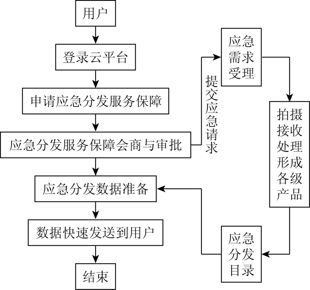
时效需求: 要求较高,数据类产品一般为近实时保障,文字报告产品一般优于24 h
内容需求: 一般多需实时影像数据、气象条件及基础地理信息等,时相要求高。如灾害或突发区域影像图、重要设施位置图、救援力量部署信息、人员及财产受损情况、救援进展动向情况、受灾评估、大比例尺地形图、救援区域植被覆盖、道路通行能力、安置区域等信息
场景需求 陆环境 平原场景需求: 标准影像、地图,正射影像、专题成果、数字高程模型(digital elevation model,DEM),道路、河流水系、土质、居民地、交通枢纽等
丘陵场景需求: 影像、道路、河流水系、坡度、高地、植被、通视、高程等
山地场景需求: 影像、道路(山区小路)、河流山谷、高程、坡度、通视、高地鞍息、冲沟陡崖、植被、方位等
沙漠戈壁场景需求: 影像、绿洲、道路、干河床、方位息、高程等信息
水网场景需求: 影像、河流湖泊息、船舶通行、桥梁渡口、季节、居民地等信息;
山林场景需求: 影像、道路(山区小路)、植被、河流山谷、方位、坡度、通视、居民地、高程等信息
城市场景需求: 影像、城市、重要建筑物、道路(关键街道)、高地等信息
海环境 海岸带场景需求: 影像,濒海标注、周边陆地与岛屿分布、岸滩质地、地表情况、海滩状态、陆地植被、道路等近海岸信息等
近海场景需求: 影像、近海战场周边陆地与岛屿分布、近海特性(海水特性/岸滩质地/地表情况/障碍情况)、海区情况(面积/形状与开放程度—)、海底情况(地形/底质/海峡/通道及港湾分布等)
远海场景需求: 卫星像、濒海标注材料、周边陆地与岛屿分布\海图、潮汐资料、航海通告等
内容需求 数据需求 成像遥感数据产品: 1级产品、2级产品、3级产品、4级产品、5级产品、6级产品
气象遥感数据产品: 值预报产品、卫星云图、雷达资料、热带气旋、灾害天气信息、气候产品等气象数据
地理信息产品: 海域及海陆的划界、海底地形及海洋地质等
产品需求 文字类产品: 刊物类产品、趋势类产品等
测绘类产品: 地理信息产品、各系列比例尺地图、正射影像、镶嵌影像、专题产品
气象类产品: 天气形势预报产品、气象要素预报产品、海洋物理要素产品等
定制化产品: 地理环境定制化产品、设施评估类产品等
Tab.1  遥感主要应用需求
Fig.1  基于云+端的天基遥感主要服务应用模式构成
Fig.2  订阅推送服务应用流程
Fig.3  应急推送服务应用流程
Fig.4  在线应用服务应用流程
Fig.5  标准接口服务应用流程
Fig.6  兴趣推荐应用流程
服务模式 特点 执行方式 适用范围
分发
服务
模式
点播 针对性强
面向少量用户
事件驱动
系统自动执行
突发事件
组播 方向性强
面向特定用户组
事件驱动
系统自动执行
突发事件
区域环境
广播 面向所有用户 系统自动执行 区域环境
主动
推送
模式
订阅
推送
针对性强
时效性高
用户驱动
系统自动执行
区域环境
应急
推送
需对信息分析
时效性高
事件驱动
系统自动执行
突发事件
互动
共享
模式
在线
应用
需要用户探索
针对性由用户经验和对天基遥感的了解决定
时效性弱
用户在线查询
用户在线浏览
历史信息
标准
接口
用户需了解接口
针对性较强
时效性强
用户在线访问
功能执行
信息处理等
接口功能
兴趣
推荐
需画像模型支持
针对性强
时效性强
用户在线查询,系统立即推荐响应,交互迭代执行 新用户
Tab.2  各服务模式特点比较
[1] 李晨辉, 郝利娜, 许强, 等. 基于面向对象的高分辨率遥感影像地震滑坡分层识别[J/OL]. 自然资源遥感, https://kns.cnki.net/kcms/detail/10.1759.P.20220707.1106.022.html.
Li C H, Hao L N, Xu Q, et al. Object-oriented earthquake-induced landslide hierarchical recognition based on high-resolution remote sensing images[J/OL]. Remote Sensing for Natural Resources, https://kns.cnki.net/kcms/detail/10.1759.P.20220707.1106.022.html.
[2] 董继红, 马志刚, 梁京涛, 等. 基于时序InSAR技术的滑坡隐患识别对比研究[J]. 自然资源遥感, 2022, 34(3):73-81.doi:10.6046/zrzyyg.2021333.
doi: 10.6046/zrzyyg.2021333
Dong J H, Ma Z G, Liang J T, et al. Comparative study of landslide hidden danger identification based on time-series InSAR technology[J] Remote Sensing for Natural Resources, 2022, 34(3):73-81.doi:10.6046/zrzyyg.2021333.
doi: 10.6046/zrzyyg.2021333
[3] 杨显华, 魏鹏, 吕军, 等. 基于多源遥感的采空塌陷识别技术应用研究[J]. 自然资源遥感, 2022, 34(2):162-167.doi:10.6046/zrzyyg.2021195.
doi: 10.6046/zrzyyg.2021195
Yang X H, Wei P, Lyu J, et al. Application of mining collapse recognition technology based on multi-source remote sensing[J] Remote Sensing for Natural Resources, 2022, 34(2):162-167.doi:10.6046/zrzyyg.2021195.
doi: 10.6046/zrzyyg.2021195
[4] 刘文, 王猛, 宋班, 等. 基于光学遥感技术的冰崩隐患遥感调查及链式结构研究——以西藏自治区藏东南地区为例[J]. 自然资源遥感, 2022, 34(1):265-276.doi:10.6046/zrzyyg.2021076.
doi: 10.6046/zrzyyg.2021076
Liu W, Wang M, Song B, et al. Surveys and chain structure study of potential hazards of ice avalanches based on optical remote sensing technology:A case study of southeast Tibet[J] Remote Sensing for Natural Resources, 2022, 34(1):265-276.doi:10.6046/zrzyyg.2021076.
doi: 10.6046/zrzyyg.2021076
[5] 李德仁, 沈欣, 李迪龙, 等. 论军民融合的卫星通信、遥感、导航一体天基信息实时服务系统[J]. 武汉大学学报·信息科学版, 2017, 42(11):1501-1505.
Li D R, Shen X, Li D L, et al. On Civil-military integrated spaced-based real-time information service system[J]. Geomatics and Information Science of Wuhan University, 2017, 42(11):1501-1505.
[6] 张满超, 王犇. 天基资源信息服务体系构建[J]. 指挥信息系统与技术, 2017, 8(5):62-69.
Zhang M C, Wang B. Construction of space-based resource information service system[J]. Command Information System and Technology, 2017, 8(5):62-69.
[7] 李德仁. 论“互联网+”天基信息服务[J]. 遥感学报, 2016, 20(5):708-715.
Li D R. The “Internet Plus” space-based information services[J]. Journal of Remote Sensing, 2016, 20(5):708-715.
[8] 管清波, 冯书兴, 马彦华. 天基信息服务模式研究[J]. 装备学院学报, 2012, 23(6):66-70.
Guan Q B, Feng S X, Ma Y H. Research on mode of space-based intelligence service[J]. Journal of Academy of Equipment, 2012, 23(6):66-70.
[9] 李德仁, 丁霖, 邵振峰. 面向实时应用的遥感服务技术[J]. 遥感学报, 2021, 25(1):15-24.
Li D R, Ding L, Shao Z F. Application-oriented real-time remote sensing service technology[J]. National Remote Sensing Bulletin, 2021, 25(1):15-24.
[10] 柳罡, 陆洲, 胡金晖. 基于云架构的天基信息应用服务系统设计[J]. 中国电子科学研究院学报, 2018, 13(5):526-531.
Liu G, Lu Z, Hu J H, et al. Study on the spatial information service system based on cloud architecture[J]. Journal of CAEIT, 2018, 13(5):526-531.
[11] 胡金晖, 秦智超, 石磊. 空间信息云服务平台架构及应用研究[J]. 中国电子科学研究院学报, 2016,(1):51-58.
Hu J H, Qin Z C, Shi L, et al. Research on spatial information cloud service platform and application[J]. Journal of CAEIT, 2016,(1):51-58.
[12] 李德仁, 沈欣. 我国天基信息实时智能服务系统发展战略研究[J]. 中国工程科学, 2020, 22(2):138-143.
Li D R, Shen X. Research on the development strategy of real-time and intelligent space-based information service system in China[J]. Chinese Engineering Science, 2020, 22(2):138-143.
[13] 史园莉, 孙中平, 姜俊, 等. 环境遥感云服务平台与高性能平台对比分析[J]. 国土资源遥感, 2019, 31(2):240-245.doi:10.6046/gtzyyg.2019.02.33.
doi: 10.6046/gtzyyg.2019.02.33
Shi Y L, Sun Z P, Jiang J, et al. Comparison and analysis of cloud service platform and high performance platform for environmental remote sensing[J]. Remote Sensing for Land and Resources, 2019, 31(2):240-245.doi:10.6046/gtzyyg.2019.02.33.
doi: 10.6046/gtzyyg.2019.02.33
[14] 程滔. 大数据时代遥感数据管理与服务模式[J]. 国土资源遥感, 2016, 28(4):202-206.doi:10.6046/gtzyyg.2016.04.31.
doi: 10.6046/gtzyyg.2016.04.31
Cheng T. Exploring management and service mode for remote sensing data in big data era[J]. Remote Sensing for Land and Resources, 2016, 28(4):202-206.doi:10.6046/gtzyyg.2016.04.31.
doi: 10.6046/gtzyyg.2016.04.31
[15] 龙恩, 吕守业, 岑鹏瑞, 等. 顾及用户画像的多源遥感信息智能推荐方法[J]. 测绘学报. http://kns.cnki.net/kcms/detail/11.2089.p.20220530.1711.004.html.
Long E, Lyu S Y, Cen P R, et al. An Intelligent Recommendation Method of Multi-Source Remote Sensing Information Considering User Portrait[J]. Acta Geodaetica et Cartographica Sinica. http://kns.cnki.net/kcms/detail/11.2089.p.20220530.1711.004.html.
[16] 王密, 仵倩玉. 面向星群的遥感影像智能服务关键问题[J]. 测绘学报, 2022, 51(6):1008-1016.
Wang M, Wu Q Y. Key problems of remote sensing images intelligent service for constellation[J]. Acta Geodaetica et Cartographica Sinica, 2022, 51(6):1008-1016.
[1] 张振华, 甘甫平, 王军. 面向应用需求的星载多光谱相机指标设置探讨[J]. 国土资源遥感, 2015, 27(2): 1-7.
[2] 王宜礼. 我国资源卫星资料应用对空间分辨率的需求[J]. 国土资源遥感, 2002, 14(2): 1-3.
Viewed
Full text


Abstract

Cited

  Shared   
  Discussed   
京ICP备05055290号-2
版权所有 © 2015 《自然资源遥感》编辑部
地址:北京学院路31号中国国土资源航空物探遥感中心 邮编:100083
电话:010-62060291/62060292 E-mail:zrzyyg@163.com
本系统由北京玛格泰克科技发展有限公司设计开发