Remote sensing monitoring method for flooded farmland based on domestic GF-3 radar images
YANG Chiyi1,2(), GUAN Haixiang1,2, WU Wei3, LIU Meiyu3, LI Ying4,5, SU Wei1,2()
1. College of Land Science and Technology, China Agricultural University, Beijing 100083,China 2. Key Laboratory of Remote Sensing for Agri-Hazards, Ministry of Agriculture, Beijing 100083, China 3. National Disaster Reduction Center of China, Ministry of Emergency Management of the People’s Republic of China, Beijing 100124,China 4. Henan Agrometeorological Support and Applied Technique Key Laboratory, China Meteorological Administration, Zhengzhou 450003, China 5. Henan Institute of Meteorological Sciences, Zhengzhou 450003, China
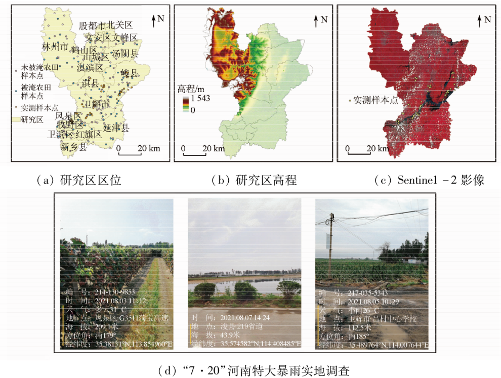
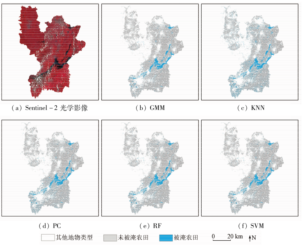
Against the backdrop of global warming, increasingly frequent floods become a primary agricultural disaster that causes reduced crop production in China. Radar remote sensing technology, possessing all-weather earth observation capabilities, serves as a critical means for rapid monitoring of regional flood information. With the advancement in artificial intelligence, machine learning methods have been extensively applied in the remote sensing-based monitoring of floods. Despite the high accuracy of their algorithms, their training processes often entail extensive field investigations or numerous samples for remote sensing image interpretation. This study aims to overcome sample labeling limitations and improve regional flood monitoring accuracy. Based on the catastrophic flood that occurred in northern Henan on July 20, 2021, this study constructed a flooded crop monitoring method based on the weakly supervised Gaussian mixture model (GMM) using domestic GF-3 HH-HV radar images. Then this method was applied to extract the flooding range of farmland in some areas of northern Henan. Compared to four typical machine learning methods, i.e., random forest (RF), support vector machine (SVM), K-nearest neighbor classification, and parallelepiped classification, the weakly supervised GMM in this study enjoyed the highest accuracy, with overall precision of 0.95 and a Kappa coefficient of 0.90. This study holds great significance for enhancing the accuracy and universality of regional crop flooding monitoring based on remote sensing technology and synthetic aperture radars (SARs).
Tong X H, Luo X, Liu S G, et al. An approach for flood monitoring by the combined use of Landsat 8 optical imagery and COSMO-SkyMed radar imagery[J]. ISPRS Journal of Photogrammetry and Remote Sensing, 2018, 136:144-153.
doi: 10.1016/j.isprsjprs.2017.11.006
Xu Z X, Liu L, Yang X J. Study on extreme climate events and drought/flood disasters:Review and prospect[J]. China Flood & Drought Management, 2017, 27(1):66-74.
Cao L D, Li J L. Integrated risk assessment of flood disaster in Zhejiang Province based on RS and GIS[J]. Journal of Natural Disasters, 2015, 24(4): 111-119.
Wang G J, Hu Y F, Zhang S, et al. Water identification from the GF-1 satellite image based on the deep convolutional neural networks[J]. National Remote Sensing Bulletin, 2022, 26(11): 2304-2316.
doi: 10.11834/jrs.20210175
Liu Y C, Gao Y N. Surface water extraction in Yangtze River basin based on sentinel time series image[J]. National Remote Sensing Bulletin, 2022, 26(2):358-372.
doi: 10.11834/jrs.20211287
[6]
Shao J L, Gao H, Wang X, et al. Application of Fengyun-4 satellite to flood disaster monitoring through a rapid multi-temporal synthesis approach[J]. Journal of Meteorological Research, 2020, 34(4):720-731.
doi: 10.1007/s13351-020-9184-9
[7]
Cohen J, Riihimäki H, Pulliainen J, et al. Implications of boreal forest stand characteristics for X-band SAR flood mapping accuracy[J]. Remote Sensing of Environment, 2016, 186: 47-63.
doi: 10.1016/j.rse.2016.08.016
[8]
Jedlovec G. Advances in geoscience and remote sensing[M]. London:Intech, 2009:679-708.
[9]
Brisco B, Touzi R, Van der Sanden J J, et al. Water resource applications with RADARSAT-2:A preview[J]. International Journal of Digital Earth, 2008, 1(1):130-147.
doi: 10.1080/17538940701782577
[10]
Hess L L, Melack J M. Remote sensing of vegetation and flooding on Magela Creek Floodplain (Northern Territory,Australia) with the SIR-C synthetic aperture radar[J] .Hydrobiologia, 2003, 500:65-82.
doi: 10.1023/A:1024665017985
Zhang Q J. System design and key technologies of the GF-3 satellite[J]. Acta Geodaetica et Cartographica Sinica, 2017, 46(3): 269-277.
doi: 10.11947/j.AGCS.2017.20170049
Guo S C, Du P J, Meng Y P, et al. Dynamic monitoring on flooding situation in the middle and lower reaches of Yangtze River region using Sentinel-1A time series[J]. National Remote Sensing Bulletin, 2021, 25(10): 2127-2141.
doi: 10.11834/jrs.20210547
Yu Z Q, Wang Y H, Liu W S, et al. Flood extent extraction method based on the texture features of GF-3 images[J]. Bulletin of Surveying and Mapping, 2022, 542(5): 26-31.
[14]
Nemni E, Aylett B J, Belabbes S, et al. Fully convolutional neural network for rapid flood segmentation in synthetic aperture radar Imagery[J]. Remote Sensing, 2020(12):2532.
[15]
Lyu W T, Yu Q Z, Yu W X. Water extraction in SAR images using GLCM and Support Vector Machine[C]// IEEE 10th International Conference on Signal Processing Proceedings,IEEE, 2010: 740-743.
[16]
Zhang S C, Ma Z M, Li Z H, et al. Using CYGNSS data to map flood inundation during the 2021 extreme precipitation in Henan Province,China[J]. Remote Sensing, 2021, 13 (24):5181.
doi: 10.3390/rs13245181
[17]
Li Z P, Liu Y L, Cheng Y F, et al. Sentinel-2A MSI and Landsat 8 OLI provide complementary information for estimating chlorophyll-a concentration in a turbid and eutrophic reservoir[J]. Remote Sensing of Environment, 2016, 173:236-247.
Huang M M. Research on flood disaster monitoring and prediction in Shouguang City based on Seminel-1/2 data[D]. Nanjing: Nanjing University of information Science & Technology, 2022.
[24]
Wang L H, Ma H, Li J L, et al. An automated extraction of small- and middle-sized rice fields under complex terrain based on SAR time series:A case study of Chongqing[J]. Computers and Electronics in Agriculture, 2022(200):107232.
 2023, Vol. 35
  ), 官海翔1,2, 吴玮3, 刘美玉3, 李颖4,5, 苏伟1,2(