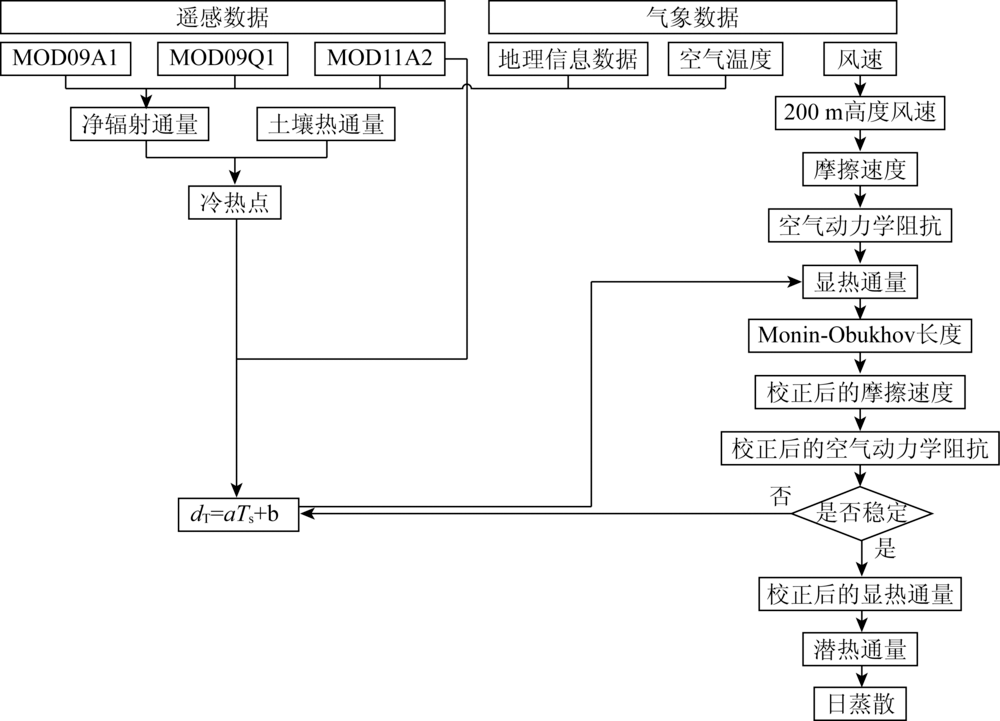
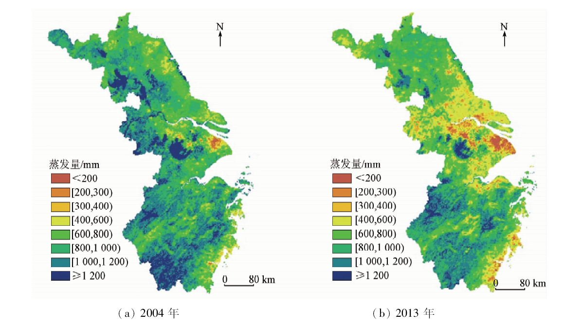
地表蒸散的准确估算对于研究区域尺度上因气候或土地利用变化引起的水量-能量变化有着重要的意义。本研究集成MODIS数据,利用陆面能量平衡模型(surface energy balance algorithm for land,SEBAL),对江苏、浙江和上海市地区(以下简称江浙沪)地区2002—2015年间生长季的蒸散进行了估算,并使用蒸渗仪地表观测数据对模型进行了验证。在总结蒸散时间扩展方法的基础上,对区域蒸散进行了月、季节尺度的扩展,计算得到区域月、季节尺度的蒸散量。并选取特征年2004年与2013年来分析日尺度与生长季尺度的空间蒸散特征。研究表明,SEBAL模型较适用于江浙沪地区的蒸散估算,该地区的年生长季蒸散范围跨度较大,在空间上呈现南高北低的特征,2004年区域生长季蒸散平均值为930 mm; 2013年为758 mm,低于2004年的蒸散值。对特定地物提取的生长季日平均蒸散进行统计发现,江浙沪地区的自然地物蒸散要高于人造地物,而在自然地物中,水体>林地>滩涂滩地>草地>未利用地。而对于人造地物,城镇的蒸散值很低,而水田、旱地以及农村居民点的蒸散值较高。
The evapotranspiration in the Jiangsu-Zhejiang-Shanghai Area during the 2004 and 2013 growing seasons was estimated by integrating the MODIS remote sensing data and using the Surface Energy Balance Algorithm for Land (SEBAL) model, and the model was validated using the surface observation data of the lysimeter. On the basis of summarizing the evapotranspiration time-space expansion method, the crop volatility method was used to expand the regional evapotranspiration on the monthly and seasonal scales, and the evapotranspiration of the regional monthly and seasonal scales was calculated. The results show that the SEBAL model is more suitable for evapotranspiration estimation in this region. The evapotranspiration range of the annual growing season in the Jiangsu-Zhejiang-Shanghai Area is wider, and the southern evapotranspiration is higher in the region. The average evapotranspiration in the regional growing season in 2013 was 758 mm. It was lower than the average evapotranspiration of about 930 mm in the growing season in 2004 . According to the statistics of the average daily evapotranspiration of the growing seasons, the authors have found that the natural land use evapotranspiration of the Jiangsu-Zhejiang-Shanghai Area is higher than that of the artificial land use, while in natural land use, the evapotranspiration is in order of water>forest>beach land>grassland>unused land. For artificial land use, the evapotranspiration of urban area is significantly low, while the evapotranspiration values of paddy fields, dry land and rural area are relatively high, and the difference is insignificant.
金楷仑, 郝璐. 基于遥感数据与SEBAL模型的江浙沪地区地表蒸散反演[J]. 国土资源遥感, 2020, 32(2): 204-212.
Kailun JIN, Lu HAO. Evapotranspiration estimation in the Jiangsu-Zhejiang-Shanghai Area based on remote sensing data and SEBAL model. Remote Sensing for Land & Resources, 2020, 32(2): 204-212.
Jiang L, Islam S, Guo W, et al. A satellite-based daily actual evapotranspiration estimation algorithm over South Florida[J]. Global and Planetary Change, 2009,67(1-2):62-77.
doi: 10.1016/j.gloplacha.2008.12.008
Zhang Y H, Wang X L, Hu G C. Evapotranspiration estimation of Hailiu River Basin based on MODIS data[J]. Earth Science—Journal of China University of Geosciences, 2012,37(2):375-380.
Han S J, Zhang B Z. Advances of evapotraspiration research based on the Penman approach and complementary principle[J]. Journal of Hydraulic Engineering, 2018,49(9):1158-1168.
[5]
Penman H L. Natural evaporation from open water,bare soil and grass[J]. Proceedings of the Royal Society of London, 1948,193(1032):120-145.
[6]
Monteith J I L. Evaporation and environment[J]. Symposia of the Society for Experimental Biology, 1965,19:205-234.
[7]
Cai J, Liu Y, Lei T, et al. Estimating reference evapotranspiration with the FAO Penman-Monteith equation using daily weather forecast messages[J]. Agricultural and Forest Meteorology, 2007,145(1-2):22-35.
[8]
Wilm H G, Thornthwaite C W, Colman E A, et al. Report of the committee on transpiration and evaporation,1943—44[J]. Eos Transactions American Geophysical Union, 1944,25(5):683-693.
[9]
Swinbank W. The measurement of vertical transfer of heat and water vapor by eddy the lower atmosphere[J]. Meteorol, 1951,8(3):135-145.
Zhang R H, Du J P, Sun R. Review of estimation and validation of regional evapotranspiration based on remote sensing[J]. Advances in Earth Science, 2012,27(12):1295-1307.
Yao Y J, Cheng J, Zhao S H, et al. Estimation of farmland evapotranspiration:A review of methods using thermal infrared remote sensing data[J]. Advances in Earth Science, 2012,27(12):1308-1318.
[12]
Bhattarai N, Shaw S B, Quackenbush L J, et al. Evaluating five remote sensing based single-source surface energy balance models for estimating daily evapotranspiration in a humid subtropical climate[J]. International Journal of Applied Earth Observation & Geoinformation, 2016,49:75-86.
[13]
Bastiaanssen W G M. SEBAL-based sensible and latent heat fluxes in the irrigated Gediz Basin,Turkey[J]. Journal of Hydrology(Amsterdam), 2000,229(1-2):87-100.
[14]
Hao L, Sun G, Liu Y Q, et al. Urbanizaiton dramatically altered the water balances of a paddy field-dominated basin in southern China[J]. Hydrology and Earth System Sciences, 2015,19(7):3319-3331.
[15]
Hao L, Huang X L, Qin M S, et al. Ecohydrological processes explain urban dry island effects in a wet region,southern China[J]. Water Resources Research, 2018,54(9):6757-6771.
Feng T M. Study of Evapotranspiration estimaition by remote sensing of eastern agricultural area in Qinghai Province based on SEBAL model[D]. Yang Ling:Northwest F&A University, 2015: 13-14.
[17]
刘志红 Li L T, Mcvicar T R, et al. 专用气候数据空间插值软件ANUSPLIN及其应用[J]. 气象, 2008,34(2):92-100.
Liu Z H, Li L T, Mcvicar T R, et al. Introduction of the professional interpolataion software for meteorlogy data:ANUSPLIN[J]. Meteorlogical Monthly, 2008,34(2):92-100.
[18]
Raúl E.Rivas, Carmona F. Evapotranspiration in the Pampean Region using field measurements and satellite data[J]. Physics and Chemistry of the Earth Parts A/B/C, 2013,55(2):27-34.
[19]
Du J, Song K S, Wang Z M, et al. Evapotranspiration estimation based on MODIS products and surface energy balance algorithms for land mdoel in Sanjiang Plain northeast China[J]. Chinese Geographical Science, 2013,23:73-91.
Wu G P, Liu Y B, Zhao X S, et al. Spatial-temporal variation of evapotranspiration in Poyang Lake Basin using MOD16 products[J]. Geographical Rsearch, 2013,32(4):617-627.
[21]
Li X, He Y, Zeng Z, et al. Spatiotemporal pattern of terrestrial evapotranspiration in China during the past thirty years[J]. Agricultural & Forest Meteorology, 2018,259:131-140.
Yang L Z, Zhang Q, Hao X C, et al. Estimation of surface evapotranspiration and spatial distribution analysis in Loess Plateau[C]// Annual meeting of China Meteorological Society s12 Annual meeting of China Meteorological Society. 2014: 239-256.
Feng F, Yao Y J, Zhang Y B, et al. Spatio-temporal variations of evapotranspiration in Sanjiang Plain using MOD16 products[J]. Ecology and Environmental Sciences, 2015,24(11):1858-1864.
Du J, Zhang B, Song K S, et al. Estimated evapotranspiration based on NOAA/AVHRR data in the Sanjiang Plain[J]. Research of Soil and Water Conservation, 2009,16(2):56-62.
Huang F Y, He B F, Wang X, et al, Spatio-temporal variations of evapotranspiration in Anhui Province based on MOD16 products[J]. Agricultural Science & Technology, 2017,18(11):2092-2097.
[26]
Timmermans W J, Kustas W P, Anderson M C, et al. An intercomparison of the surface energy balance algorithm for land(SEBAL) and the two-source energy balance(TSEB) modeling schemes[J]. Remote Sensing of Environment, 2007,108(4):369-384.
doi: 10.1016/j.rse.2006.11.028
[27]
Yang Y, Shang S, Jiang L. Remote sensing temporal and spatial patterns of evapotranspiration and the responses to water management in a large irrigation district of North China[J]. Agricultural and Forest Meteorology, 2012,164:112-122.
doi: 10.1016/j.agrformet.2012.05.011
Zhou Y Z, Zhou J, Li Y, et al. Simulating the evapotranspiration with SEBAL and modified SEBAL(M-SEBAL) models over the desert and oasis of the middle reaches of the Heihe River[J]. Journal of Glaciology and Geocryology, 2014,36(6):1526-1537.
doi: 10.7522/j.issn.1000-0240.2014.0183
[29]
Sun Z, Wei B, Su W, et al. Evapotranspiration estimation based on the SEBAL model in the Nansi Lake Wetland of China[J]. Mathematical & Computer Modelling, 2011,54(3):1086-1092.
Du J, Zhang B, Song K S, et al. Study on daily evapotranspiration estimation of Sanjiang Plain based on MODIS product and SEBAL model[J]. Chinese Journal of Agrometeorology, 2010,31(1):104-110.
[31]
Li Z, Liu X, Ma T, et al. Retrieval of the surface evapotranspiration patterns in the alpine grassland-wetland ecosystem applying SEBAL model in the source region of the Yellow River,China[J]. Ecological Modelling, 2013,270:64-75.
doi: 10.1016/j.ecolmodel.2013.09.004
 2020, Vol. 32
  )
)