Design and development of an information system for the accounting of state-owned land resource assets
HUANG Tao1(), LIU Xiaoping2, WU Jiaping3,4(), XIAO Yanling1, ZHANG Yuchen1
1. Guangdong Provincial Land and Resources Technology Center, Guangzhou 510075, China 2. School of Geograhy and Planning, Sun Yat-sen University, Guangzhou 510275, China 3. Key Laboratory of Carbon Neutral and Territorial Spatial Optimization, Ministry of Natural Resources, Nanjing 210023, China 4. Guangdong Guodi Resources and Environment Research Institute, Guangzhou 510650, China
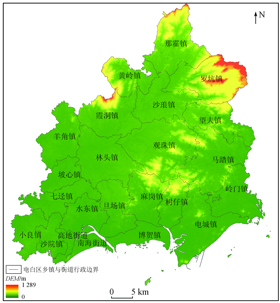
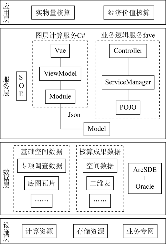
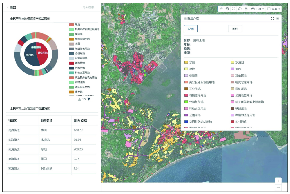
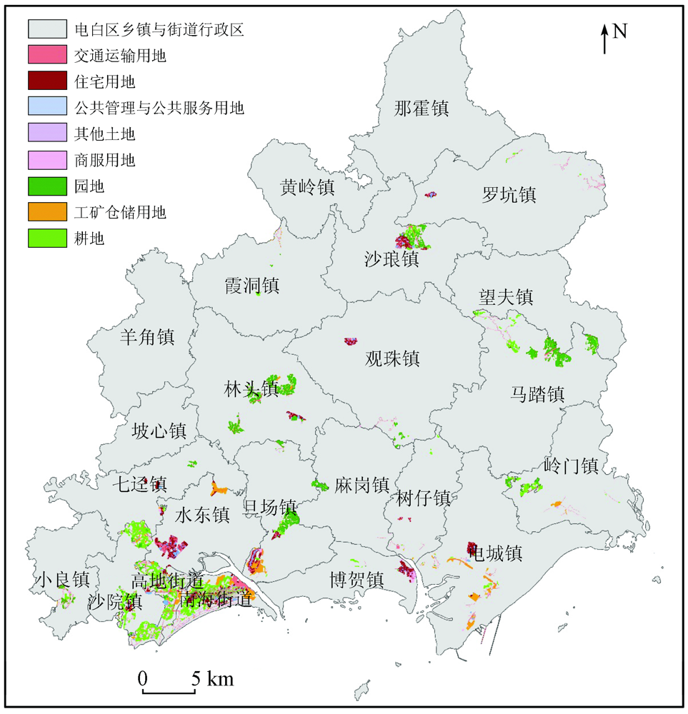
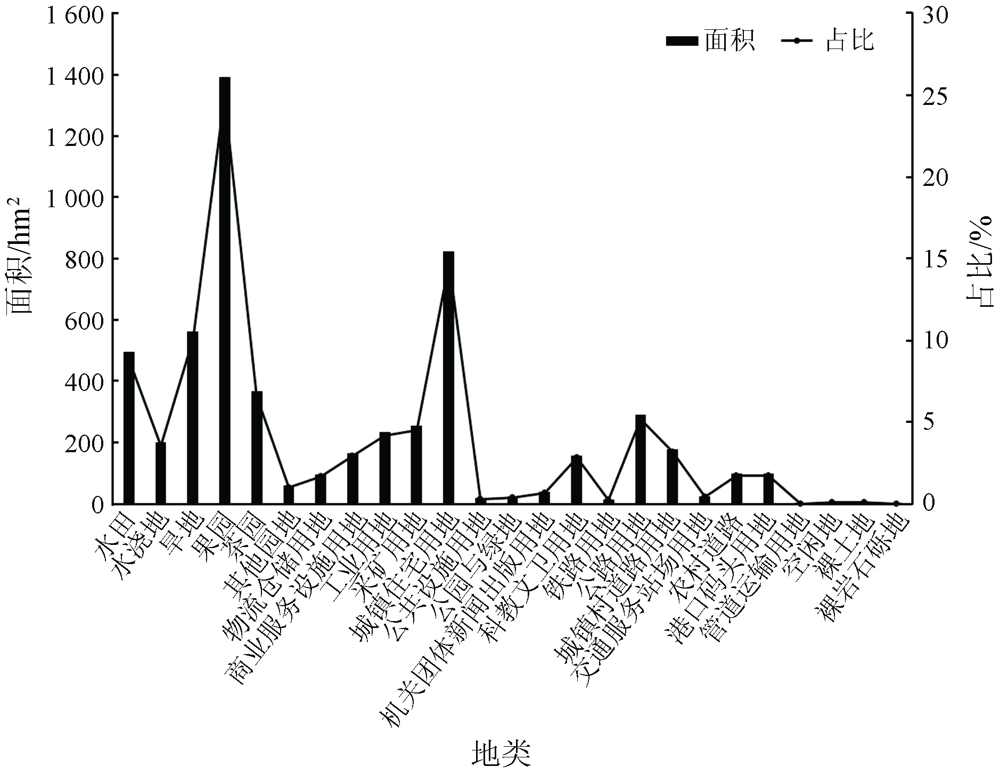
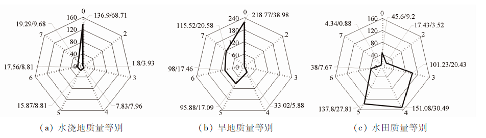
Accounting for natural resource assets is the main part in ascertaining the state-owned natural resource assets and is also a fundamental task in determining various natural resources. It is of great practical significance to design and develop an information system for the accounting treatment of state-owned land resource assets. Taking the accounting treatment of the state-owned land resource assets in Dianbai District, Guangdong Province as an example, this study designed and developed an automatic accounting system of state-owned land resource assets using the WebGIS integrated architecture based on the data from land surveys, parcels of land, and benchmark land prices and following the methods and procedures for the accounting treatment of state-owned land resource assets. The research results are as follows. The state-owned land resources in Dianbai District have a total area of 5 582.31 hm2, among which, the cultivated land has an area of 1 255.94 hm2. There is a small amount of high-quality cultivated land, with the second-class land only covering an area of 17.43 hm2. The economic value of state-owned agricultural land and construction land is approximately RMB 1 397.360 5 million and RMB 1 639.014 4 million, respectively. The results of this study will provide technical references for ascertaining the state-owned natural resource assets and preparing the balance sheets, thereby promoting the information-based management of natural resource assets.
黄韬, 刘小平, 吴佳平, 肖燕玲, 张雨辰. 国有土地资源资产核算信息化设计与实现[J]. 自然资源遥感, 2022, 34(3): 249-256.
HUANG Tao, LIU Xiaoping, WU Jiaping, XIAO Yanling, ZHANG Yuchen. Design and development of an information system for the accounting of state-owned land resource assets. Remote Sensing for Natural Resources, 2022, 34(3): 249-256.
Yang H L, Wei Q W, Chen J K. Quantifying the payments for ecosystem services and the value of natural resources based on the indicator of optional capacity value:A case study on water resources supply in Zhujiang River basin,China[J]. Acta Ecologica Sinica, 2020, 40(10):3218-3228.
Xue Z C, Min H M, Yang Y Z, et al. Design and empirical study of a land resource accounting system for natural resources asset balance-sheet compilation[J]. Resources Science, 2015(9):43-49.
Kong H X, Shen L, Zhong S, et al. Research progress and controversial issues of natural resources accounting[J]. Journal of Natural Resources, 2016, 31(3):363-376.
Zhu D L, Zhang H, Duan W J, et al. Discussion on the logical rules of natural resources asset accounting and the methods of land resource asset accounting[J]. China Land Sciences, 2019, 33(11):1-7.
Zhang Y, Pan J. Research on China’s forest resource asset accounting and liability sheet compilation:Based on forest resource inventory data[J]. Journal of China University of Geosciences(Social Sciences Edition), 2016(6):46-53.
Sun D M, Zeng W H. Design and implementation of universal industry geographic information acquisition platform[J]. Science of Surveying and Mapping, 2020, 45(6):7.
Yu J, Tong Q Y, Zhu B, et al. Design and implementation of the hybrid-pattern-based land investigation APP:Taking Wuhan City land planning law enforcement monitoring mobile system as an example[J]. Science of Surveying and Mapping, 2018(1):151-156.
Mi X Y. The research and design on information system of temporal forest resource management based on open source WebGIS[D]. Changsha: Central South University of Forestry & Technology, 2017.
Zeng Y M, Lyu M. The online publication system of five mini-conservancy projects based on WebGIS[J]. Bulletin of Surveying and Mapping, 2019(s1):263-265.
Wang Q Z, Zhao X W, Yang J, et al. An intelligent subervision method for soil remediation project[J]. Science of Surveying and Mapping, 2019, 44(3):15-20.
Wang Y J, Di Z Z. On land classification conversion between the second and the third national land surveying[J]. Standardization of Surveying and Mapping, 2019, 35(2):6.
Yan H M, Feng Z M, Yang Y Z, et al. First report of the national natural resources balance sheet for Huzhou City and Anji County[J]. Resources Science, 2017, 39(9):1634-1645.
Shi W, Xu A T, Li J C, et al. Study on the preparation of natural resources balance sheet: A case study of forest resources[J]. Journal of Natural Resources, 2018(4):541-551.
Yu Y Y, Li X, Chen Y P. Design of terminal adaptive dynamic form based on frontend-backend separation[J]. Computer Systems & Applications, 2018, 27(4):70-75.
[17]
Psaila G. Virtual DOM:An efficient virtual memory representation for large XML documents[C]// International Workshop on Database & Expert Systems Applications.IEEE, 2008.
Chen J M. A application of SOE in web distribution service system for surveying and mapping results[J]. Geomatics & Spatial Information Technology, 2016(7):104-105.
Xu L. Study of method about server object extension based on ArcGIS Server[J]. Geomatics & Spatial Information Technology, 2016, 39(1):67-69.
[22]
Johnson R, Hoeller J, Arendsen A, et al. Spring,Java/J2EE Application Framework[EB/OL]. https://docs.spring.io/spring-framework/docs/1.2.x/reference/index.html.
Liu J B, Yu J T, Yu L S, et al. Design and implementation of “one map” system of agricultural geology in Shandong Province[J]. Journal of Shandong Agricultural University (Natural Science Edition), 2021, 52(3):496-499.
Zhao Y H, Guo X W, Cao X, et al. Design of geographic information system for water pollution automatic monitoring in Henan Province[J]. Journal of Henan University(Natural Science), 2019, 49(5):559-566.
 2022, Vol. 34
  ), 刘小平2, 吴佳平3,4(