Multifactor-based assessment of forest fire risk in Chongqing City, China
CHEN Yanying1(), YOU Yangsheng2(), YANG Qian3, WANG Yanbo4
1. CMA Key Open Laboratory of Transforming Climate Resources to Economy, Chongqing Institute of Meteorological Sciences, Chongqing 401147, China 2. School of Civil Engineering,Chongqing University Chongqing 400045, China 3. Chongqing Meteorological Station, Chongqing 401147, China 4. Chaoyang Normal University, Chaoyang 122000, China
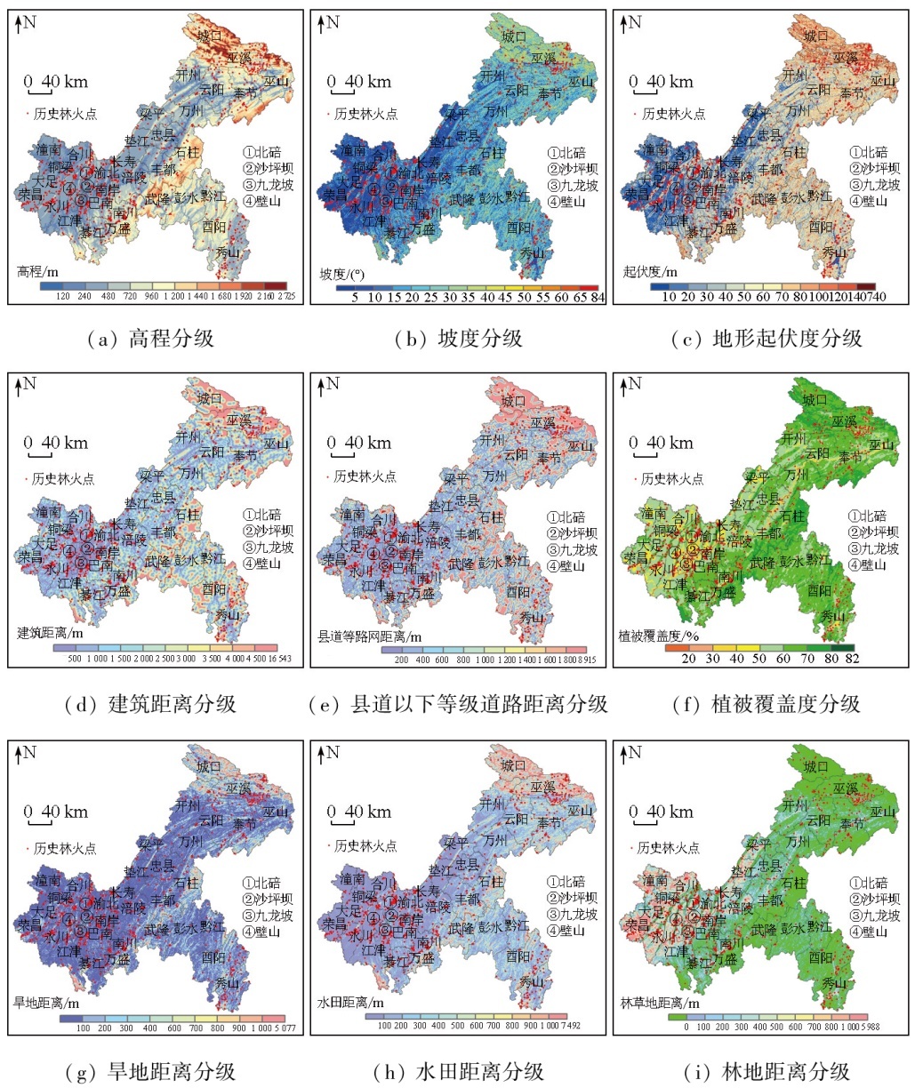
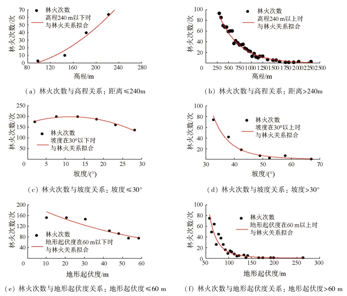
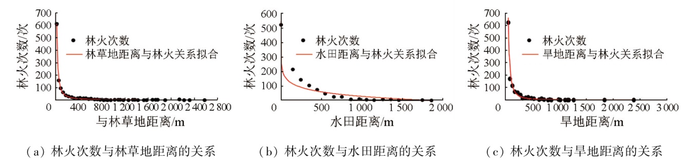
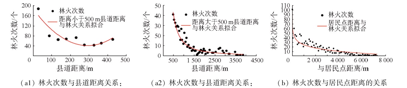
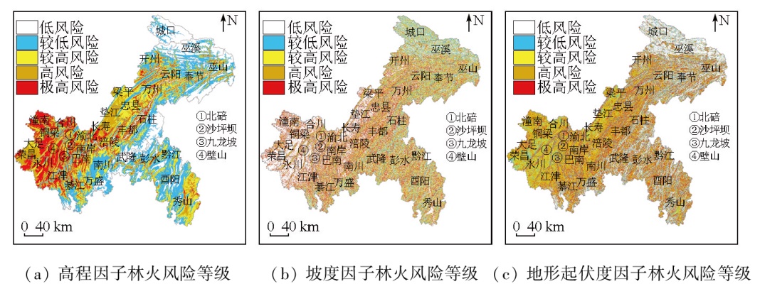
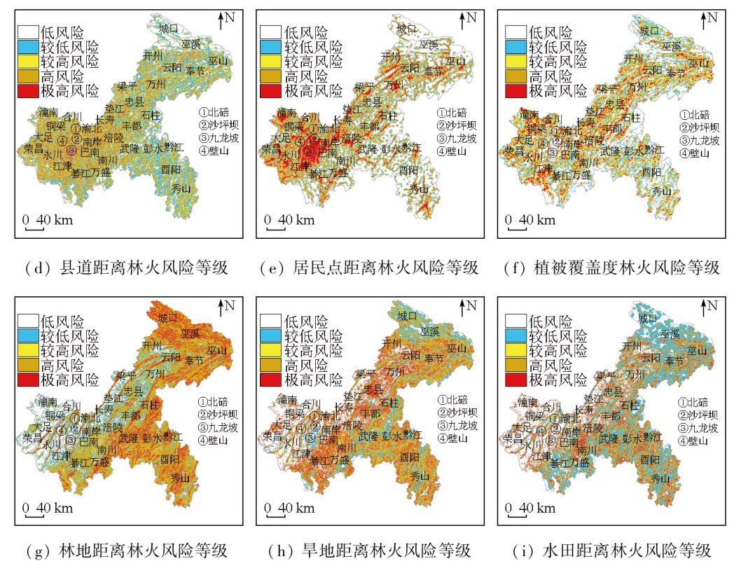
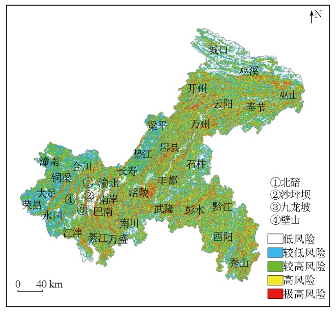
By objectively assessing the response of forest fires to factors like terrain, vegetation, and human activities, this study aims to provide technical guidance for forest fire prevention and risk zoning in Chongqing City, China. In this study, 1 206 historical forest fire data of Chongqing City from 2000 to 2022 were used as dependent variables. The height, slope, terrain ruggedness, vegetation cover, land cover classification, and road network distance data were utilized as forest fire risk factors. With these data, a piecewise function was established to obtain the single-factor risk probabilities of forest fires. Based on the criteria importance through intercriteria correlation (CRITIC), the weights of the single-factor risk probabilities of forest fires were calculated to derive the spatial distribution of weighted forest fire risk probabilities in Chongqing City. Finally, according to the risk probabilities of forest fires, the forest fire risk in Chongqing City was divided into the low, relatively low, relatively high, high, and extremely high levels. The results indicate that among nine forest fire risk factors, the contributions of forest land, dry land, and vegetation cover to forest fire risk ranked top three, whereas the slope, height, and terrain ruggedness contributed little to forest fire risk. The forest fire risk levels of Chongqing City based on the weights of single-factor risk probabilities demonstrated satisfactory verification effects. Forest fires falling in zones at relatively high and above risk levels represented 83 %. In contrast, forest fires falling in zones at low and relatively low risk levels represented 8.33 % and 8.67 %, respectively. The forest fire risk in Chongqing City was intimately associated with the terrain trend, land use, and human activities. The high-risk and extremely high-risk zones were primarily distributed in low to middle mountain forest areas subjected to frequent human activities. Additionally, the areas surrounding forest land, located near farmland, rural roads, residential areas, and cemeteries, were also classified into high-risk zones since the frequent use of fire for production and daily life was prone to induce forest fires. The low-risk zones included primarily low and flat non-forest areas and steep forest areas, along with building land, water bodies, and paddy and dry lands that are far from forest land. Overall, the results of this study can be used to assess the spatial distribution of forest fire risk, providing scientific guidance for forest fire prevention.
陈艳英, 游扬声, 杨茜, 汪艳波. 基于多因子的重庆市林火风险评价[J]. 自然资源遥感, 2025, 37(3): 152-161.
CHEN Yanying, YOU Yangsheng, YANG Qian, WANG Yanbo. Multifactor-based assessment of forest fire risk in Chongqing City, China. Remote Sensing for Natural Resources, 2025, 37(3): 152-161.
Wang A, Wang C H, Gao G Y, et al. Analysis of dominant causes and rescue casualties of forest fires in China from 2000 to 2022[J]. Forest and Grassland Resources Research, 2024(1):1-7.
Huang C Y, Wei L Y, He L Y, et al. Analysis of meteorological grade characteristics and causes of forest fire risk in Guangxi from 1981 to 2020[J]. Meteorological Science and Technology, 2023, 51(6):879-887.
Du J H, Gong Y T, Jiang L W. Study on the characteristics of forest fires in China and their relationship with major climatic factors[J]. Forest Resources Management, 2019(2):7-14.
Liu X G, Zhang J. Weather situation with high forest fire risk and its climatic characteristics and forecast[J]. Journal of Natural Disasters, 2010, 19(1):192-198.
Yang Y, Pan J, Wang X Z, et al. A method for predicting forest fire risk levels by integrating meteorological and soil factors:China,202311741191.2[P]. 2023-12-18.
Fu Z Q, Dai E F. Seasonal dynamic characteristics and climatic condition analysis of forestry fire risk in Daxing’an Mountains[J]. Journal of Natural Disasters, 2001, 10(4):113-116.
Wang D L, Yang X B, Luo X M, et al. Discussion on meteorological forecast grade model of forest fire danger in villages and towns in southern Anhui mountainous area[J]. Modern Agricultural Science and Technology, 2022(10):149-152.
Li R, Fu Y, Hu J, et al. Method for estimating forest fire frequency and intensity based on satellite microwave index and meteorological index:China,CN113886763B[P]. 2023-08-29.
[14]
陈安猛. 基于SAR图像地表参数反演的山火预警方法研究[D]. 成都: 电子科技大学, 2015.
Chen A M. Method research of forest fire warning based on SAR images[D]. Chengdu: University of Electronic Science and Technology of China, 2015.
Su L J, He Y J, Chen S Z. Temporal and spatial characteristics and risk analysis of forest fires in China from 1950 to 2010[J]. Scientia Silvae Sinicae, 2015, 51(1):88-96.
Zhu Z, Zhao F, Wang Q H, et al. Driving factors of forest fire and fire risk zoning in Kunming City[J]. Journal of Zhejiang A and F University, 2022, 39(2):380-387.
Wang S, Zhang G, Tan S Q, et al. Assessment of forest fire risk in Hunan Province based on spatial logistic model[J]. Journal of Central South University of Forestry and Technology, 2020, 40(9):88-95.
Deng O, Li Y Q, Feng Z K, et al. Model and zoning of forest fire risk in Heilongjiang Province based on spatial Logistic[J]. Transactions of the Chinese Society of Agricultural Engineering, 2012, 28(8):200-205.
Li H P, Long Z H, Yang Z H, et al. Analysis of forest fire risk in Sichuan Liangshan based on Logistic model[J]. Journal of Safety and Environment, 2021, 21(2):498-505.
Chen Y Y, You Y S, Tang Y H. Research of forest fire zoning based on local topography and fire numbers[J]. Journal of Natural Disasters, 2015, 24(2):228-234.
Zheng Z, Gao Y H, Yang Q Y. et al. Research on the construction of composite risk prediction model for forest fire in the mountainous area of southwestern China:Taking Chongqing City as an example[J]. Journal of Natural Disasters, 2020, 29(1):152-161.
Jia X. Distribution characteristics and risk assessment of fire in Inner Mongolia based on remote sensing data[D]. Hohhot: Inner Mongolia Agricultural University, 2018.
Tan S Q, Lin Q, Zhang S, et al. Study on forest fire danger division based on variable fuzzy sets method[J]. Journal of Central South University of Forestry & Technology, 2015, 35(9):35-38.
Wang L T, Zhou Y, Qiao D J. et al. Fire danger rating assessment and spatial-temporal characteristic analysis of forest and grassland in North China using remote sensing[J]. Remote Sensing Information, 2011, 26(3):44-49.
Chen Y Y, You Y S, He Z M, et al. Analysis on temporal-spatial feature of forest fires in Chongqing[J]. Chinese Agricultural Science Bulletin, 2014, 30(13):51-58.
doi: 10.11924/j.issn.1000-6850.2013-2849
Lu Q H, Wang X Q, Cao H, et al. Remote sensing monitoring of forest fire in Liangshan Prefecture,Sichuan Province[J]. Surveying and Mapping of Geology and Mineral Resources, 2020, 36(4):9-12.
Liu Y, Deng W, Song X Q, et al. Population density correction method in mountain areas based on relief degree of land surface:A case study in the upper Minjiang River Basin[J]. Scientia Geographica Sinica, 2015, 35(4):464-470.
doi: 10.13249/j.cnki.sgs.2015.04.464
Zhang J, Li X D, Chen C Y, et al. Analysis of the relief amplitude in Xinjiang[J]. Journal of Lanzhou University (Natural Sciences), 2008, 44(s1):10-13,19.
Zhou C H, Cheng W M, Qian J K, et al. Research on the classification system of digital land geomorphology of 1∶1 000 000 in China[J]. Journal of Geo-Information Science, 2009, 11(6):707-724.
[31]
周成虎. 地貌学辞典[M]. 北京: 中国水利水电出版社, 2006.
Zhou C H. A dictionary of geomorphology[M]. Beijing: China Water and Power Press, 2006.
Ha K, Ding Q L, Men M X, et al. Spatial distribution of land use and its relationship with terrain factors in hilly area[J]. Geographical Research, 2015, 34(5):909-921.
 2025, Vol. 37
  ), 游扬声2(