Remote sensing monitoring and spatiotemporal variation analysis of vegetation cover under coal mining activities in the Shendong mining area from 1986 to 2023
WANG Yi1(), ZHANG Yicong2, CHENG Yang1, XU Lianhang1, GUO Junting3, WANG Hui2, LI Jun2(), DU Shouhang2
1. China Energy Shendong Coal Group Co., Ltd., Yulin 719315, China 2. College of Geoscience and Surveying Engineering, China University of Mining and Technology - Beijing, Beijing 100083, China 3. State Key Laboratory of Water Resources Protection and Utilization in Coal Mining, Beijing 100011, China
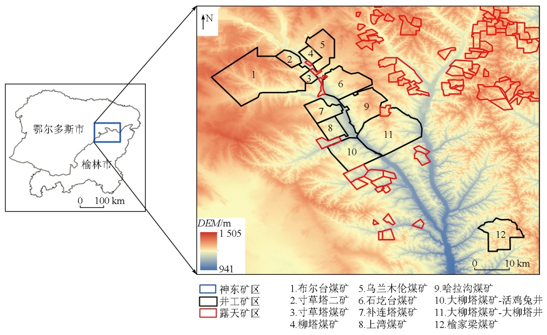
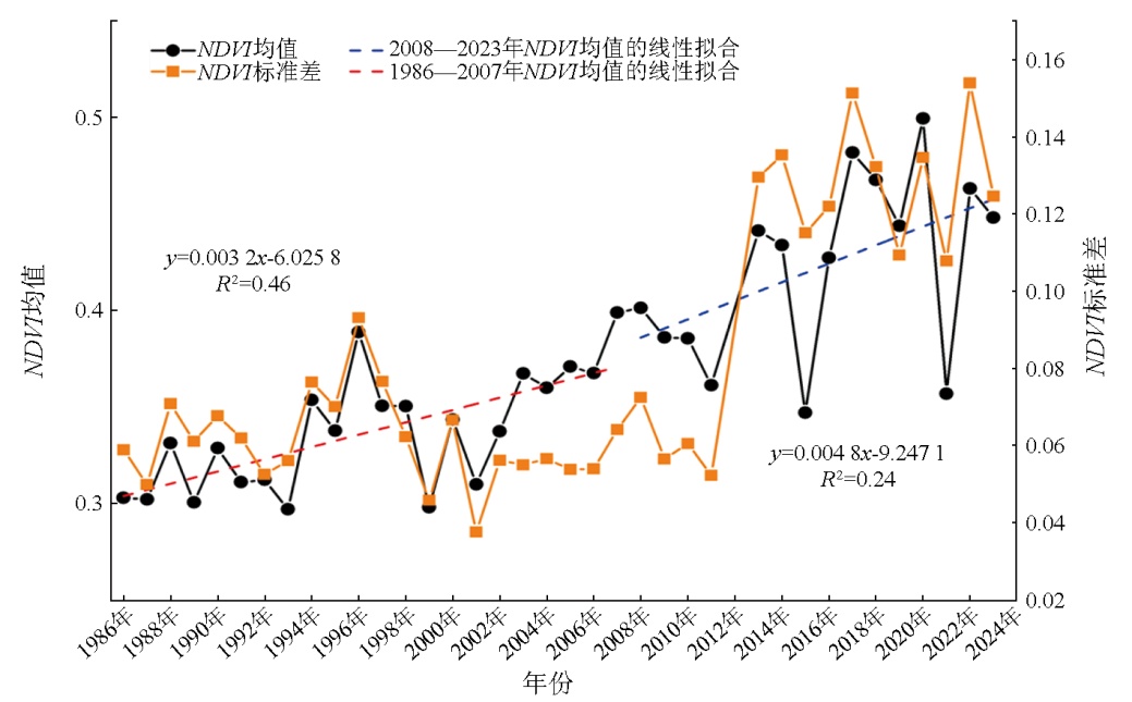
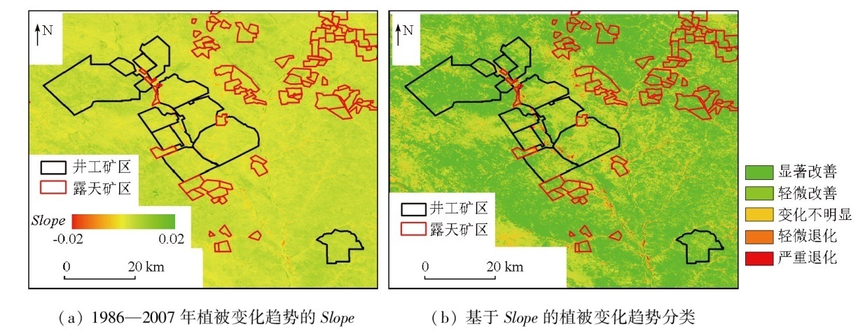
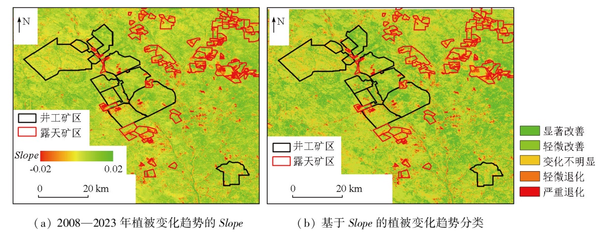
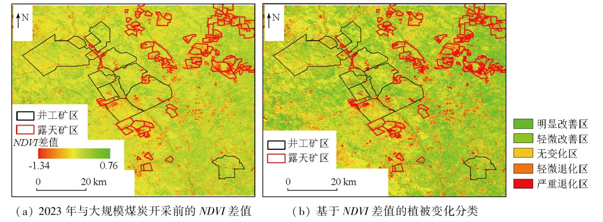
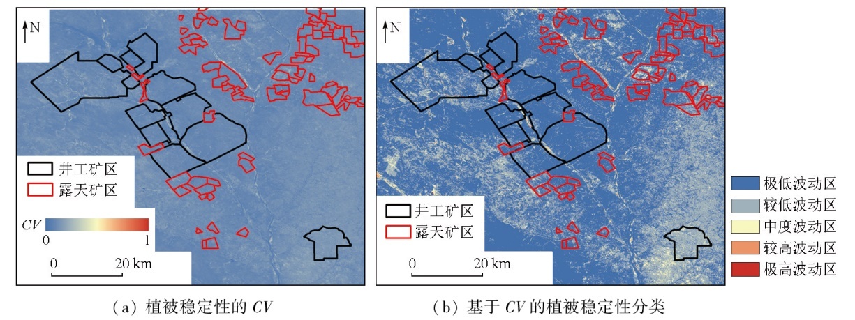
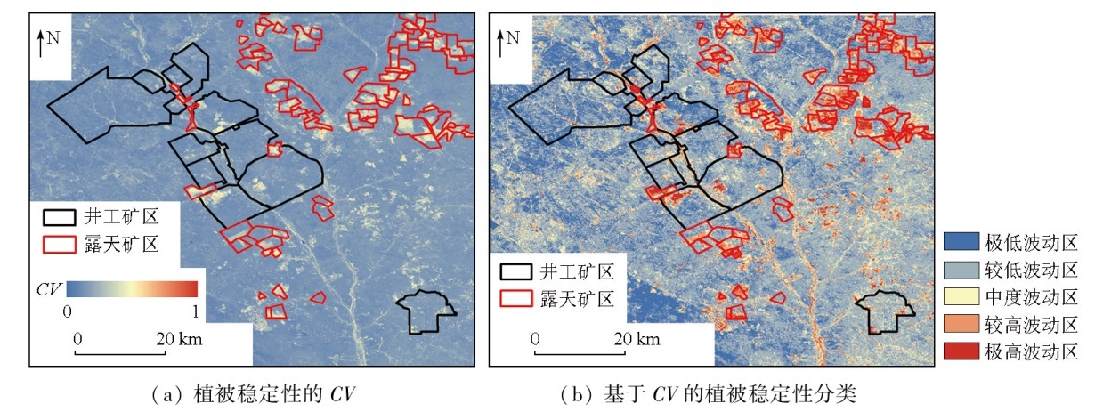
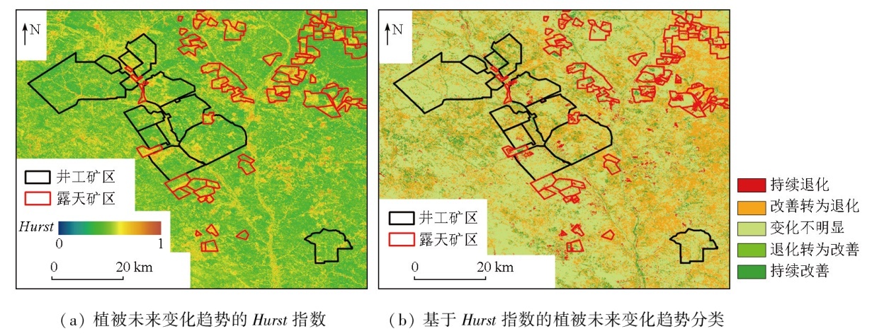
The Shendong mining area is a significant coal-producing area in China. Against the backdrop of climatic amelioration and large-scale coal mining, vegetation in the Shendong mining area has been influenced negatively by coal mining and positively by climatic amelioration and ecological restoration. Long time-series quantitative monitoring and assessment of vegetation cover in the mining area using remote sensing techniques play a significant role in local ecological quality management and ecological conservation. Based on Landsat satellite imagery data, this study conducted a long time-series monitoring of the normalized difference vegetation index (NDVI) in the Shendong mining area over a nearly 40-year period from 1986 to 2023. This monitoring focused on the interannual variations, variation trends, stability, and future variations of vegetation cover in the mining area. Moreover, this study performed a segmented quantitative analysis, taking 2008 (the onset of large-scale coal mining) as a demarcation point. The results indicate that climatic amelioration over the past nearly four decades has facilitated vegetation growth in the Shendong mining area. Despite the negative impacts of large-scale coal mining on surface vegetation, more favorable climatic conditions and ecological restoration efforts in the mining area have ensured a continuous improvement in vegetation cover, with a higher restoration rate observed locally. The Shendong mining area was characterized by improved vegetation cover across different stages,with the improved area exceeding 80 %. Large-scale coal mining caused limited vegetation deterioration, predominantly occurring in the open-pit mining area. In contrast, the vegetation restoration project in the underground mining area effectively ensured a favorable environment for vegetation growth. The vegetation cover in the Shendong mining area remained relatively stable at different stages. During large-scale coal mining, significant vegetation cover fluctuations occurred primarily in the stopes and waste dumps of the open-pit mining area. The underground mining area exhibited relatively stable vegetation cover overall, except for the land used for industrial and mining construction. Concerning future variations of vegetation cover, the Shendong mining area exhibited a relatively limited capability to maintain its current state. Due to large-scale mining activities, 3.92 % of the area underwent continuous degradation, which was primarily observed in the stopes of the open-pit mining area. This highlighted the urgent need for artificial ecological restoration in the stopes. The results of this study provide a reliable data reference for the supervision of ecological quality in the Shendong mining area, facilitating the more scientific and efficient establishment of a comprehensive ecological prevention and control system.
王义, 张艺藂, 程洋, 许联航, 郭俊廷, 王慧, 李军, 杜守航. 1986—2023年间神东矿区煤炭开采活动下植被覆盖遥感监测与时空变化分析[J]. 自然资源遥感, 2025, 37(3): 65-75.
WANG Yi, ZHANG Yicong, CHENG Yang, XU Lianhang, GUO Junting, WANG Hui, LI Jun, DU Shouhang. Remote sensing monitoring and spatiotemporal variation analysis of vegetation cover under coal mining activities in the Shendong mining area from 1986 to 2023. Remote Sensing for Natural Resources, 2025, 37(3): 65-75.
Li J, Peng S P, Zhang C Y, et al. Quantitative remote sensing-based monitoring and evaluation of the ecological environment in mining areas:Technology framework and application[J]. Journal of Mining Science and Technology, 2022, 7(1):9-25,88.
Zhang C Y, Li J, Lei S G, et al. Progress and prospect of the quantitative remote sensing for monitoring the eco-environment in mining area[J]. Metal Mine, 2022(3):1-27.
Yue H, Liu Y, Zhu R. Monitoring ecological environment change based on remote sensing ecological index in Shendong mining area[J]. Bulletin of Soil and Water Conservation, 2019, 39(2):101-107,114.
Liu Y, Lei S G, Chen X Y, et al. Temporal variation and driving factors of vegetation coverage in Shendong central mining area based on the perspective of guided restoration[J]. Journal of China Coal Society, 2021, 46(10):3319-3331.
Xu J, Wang L, Wang Y, et al. Spatiotemporal dynamic variation of vegetation NDVI in Shendong mining area from 2000 to 2017[J]. Research of Soil and Water Conservation, 2021, 28(1):153-158.
Li R, Chen G Q, Li W X, et al. Spatiotemporal analysis of eco-environmental benefits in Shenfu-Dongsheng mining area during 1995—2020 based on RSEI[J]. Bulletin of Soil and Water Conservation, 2021, 41(3):143-151.
Li J, Peng C Y, Zhang C Y, et al. General statistical rules of vegetation disturbance range by open-pit mining based on a large sample:A case study of Shendong coal base[J]. Journal of China Coal Society, 2023, 48(2):975-985.
Yang S, Ma C. Temporal and spatial changes and climate response of GIMMS NDVI3g+ (1982—2015) in Shendong mining area[C]// Proceedings of the 8th National Academic Conference on Land Reclamation and Ecological Restoration in Mining Areas of the Professional Committee of Land Reclamation and Ecological Restoration of the China Coal Society,Jiaozuo,Henan,China, 2019:345-350.
Liu Y, Hou E K, Yue H. Dynamic monitoring and trend analysis of vegetation change in Shendong mining area based on MODIS[J]. Remote Sensing for Land and Resources, 2017, 29(2):132-137.doi:10.6046/gtzyyg.2017.02.19.
Niu H B, Tian S G, Zu P J, et al. Effect of coal mining on net primary productivity of vegetation in Shendong mining area[J]. Coal Science and Technology, 2024, 52(7):267-277.
[12]
Xu Y L, Guo L, Li J, et al. Automatically identifying the vegetation destruction and restoration of various open-pit mines utilizing remotely sensed images:Auto-VDR[J]. Journal of Cleaner Production, 2023,414:137490.
Li X Q, Ma J F, Fu C C. Dataset of the 1∶50 000 hydrogeological map of the Huojitu mine area,Shendong coal base[J]. Geology in China, 2018, 45(s2):13-22,111-123.
Wang D D, Xiao L, Bi Y L, et al. Effects of AMF inoculation on plant-soil ecological stoichiometry and nutrient recovery in the Shendong mine[J]. Coal Science and Technology, 2024, 52(5):354-363.
[15]
Stow D, Daeschner S, Hope A, et al. Variability of the seasonally integrated normalized difference vegetation index across the north slope of Alaska in the 1990s[J]. International Journal of Remote Sensing, 2003, 24(5):1111-1117.
Li J, Yan X G, Yan X X, et al. Temporal and spatial variation characteristic of vegetation coverage in the Yellow River Basin based on GEE cloud platform[J]. Journal of China Coal Society, 2021, 46(5):1439-1450.
Chen H X, Zhong J S, Lan A J, et al. Analysis of temporal and spatial variation of NDVI in Guizhou Province based on landform factors[J]. Guizhou Science, 2019, 37(2):36-43.
Wang G F, Bi R T, Zhang W P, et al. Temporal and spatial distribution characteristics and influencing factors of vegetation coverage in typical mining areas[J]. Acta Ecologica Sinica, 2020, 40(17):6046-6056.
[19]
White J C, Hermosilla T, Wulder M A,, et al. Mapping,validating,and interpreting spatio-temporal trends in post-disturbance forest recovery[J]. Remote Sensing of Environment, 2022,271:112904.
Li J F, Li X B, Zhou Y. Spatiotemporal variation of NDVI and its affecting factors in Ulanqab City in growing season from 2000 to 2015[J]. Arid Zone Research, 2019, 36(5):1238-1249.
[21]
Zhang C Y, Li F Y, Li J, et al. Assessing the effect,attribution,and potential of vegetation restoration in open-pit coal mines’ dumping sites during 2003—2020 utilizing remote sensing[J]. Ecological Indicators, 2023,155:111003.
Dai Z J, Zhao X, Li G W, et al. Spatial-temporal variations in NDVI in vegetation-growing season in Qinghai based on GIMMS NDVI 3g.v1 in past 34 years[J]. Pratacultural Science, 2018, 35(4):713-725.
[23]
Oindo B O, Skidmore A K. Interannual variability of NDVI and species richness in Kenya[J]. International Journal of Remote Sensing, 2002, 23(2): 285-298.
Zhang H, An H M. Analysis of NDVl variation characteristics and trend of Minqin Oasis from 1987 to 2019 based on GEE[J]. Journal of Desert Research, 2021, 41(1): 28-36.
Zhong H P, Wang H Z. Temporal and spatial variation of norma-lized vegetation index in Hubei Province from 2007 to 2016[J]. Journal of Central China Normal University (Natural Sciences), 2018, 52(4):582-588.
Long S, Guo Z F, Xu L, et al. Spatiotemporal variations of fractional vegetation coverage in China based on Google Earth Engine[J]. Remote Sensing Technology and Application, 2020, 35(2):326-334.
Kang S Z, Mu Q, Zhao Y H, et al. Temporal and spatial pattern characteristics of ecological environmental quality in Shenfu mining area of Loess Plateau[J]. Acta Ecologica Sinica, 2023, 43(7):2781-2792.
[28]
Xiao W, Zhang W K, Ye Y M, et al. Is underground coal mining causing land degradation and significantly damaging ecosystems in semi-arid areas? A study from an ecological capital perspective[J]. Land Degradation & Development, 2020, 31(15):1969-1989.
Hu Z Q. The 30 years’ land reclamation and ecological restoration in China:Review,rethinking and prospect[J]. Coal Science and Technology, 2019, 47(1):25-35.
Li Q S, He A M, Cao Z G. Study on surface ecological self-repair under modern coal mining technology in Shendong mining area[J]. Coal Engineering, 2012, 44(12):120-122.
Gu H J. Development status and direction of green mining techno-logy in vulnerable mining areas in Western China[J]. Shaanxi Coal, 2022, 41(5):222-225.
[32]
徐清清. 神东矿区生态治理技术评价研究[D]. 徐州: 中国矿业大学, 2022.
Xu Q Q. Research on evaluation of ecological management techno-logy of Shendong mine area[D]. Xuzhou: China University of Mining and Technology, 2022.
Liu H P, Wang Y. Research and practices of countermeasures for resource and environment management in Shendong mining area[J]. China Coal, 2023, 49(s1):6-14.
 2025, Vol. 37
  ), 张艺藂2, 程洋1, 许联航1, 郭俊廷3, 王慧2, 李军2(